
The Orange River is a river in Southern Africa. It is the longest river in South Africa. With a total length of 2,432 km (1,511 mi), the Orange River Basin extends from Lesotho into South Africa and Namibia to the north. It rises in the Drakensberg mountains in Lesotho, flowing westwards through South Africa to the Atlantic Ocean. The river forms part of the international borders between South Africa and Lesotho and between South Africa and Namibia, as well as several provincial borders within South Africa. Except for Upington, it does not pass through any major cities. The Orange River plays an important role in the South African economy by providing water for irrigation and hydroelectric power. The river was named the Orange River in honour of the Dutch ruling family, the House of Orange, by the Dutch explorer Robert Jacob Gordon. Other names include simply the word for river, in Khoekhoegowab orthography written as !Garib, which is rendered in Afrikaans as Gariep River with the intrusion of a velar fricative in place of the alveolar click, Groote River or Senqu River, derived from ǂNū "Black". It is known in isiZulu as isAngqu.

The Vaal River is the largest tributary of the Orange River in South Africa. The river has its source near Breyten in Mpumalanga province, east of Johannesburg and about 30 kilometres (19 mi) north of Ermelo and only about 240 kilometres (150 mi) from the Indian Ocean. It then flows westwards to its confluence with the Orange River southwest of Kimberley in the Northern Cape. It is 1,458 kilometres (906 mi) long, and forms the border between Mpumalanga, Gauteng and North West Province on its north bank, and the Free State on its south.
Harrismith is a large town in the Free State province of South Africa. It was named for Sir Harry Smith, a 19th-century British governor and high commissioner of the Cape Colony. It is situated by the Wilge River, alongside the N3 highway, about midway between Johannesburg, about 275 km to the north-west, and Durban to the southeast. The town is located at the junction of the N5 highway, which continues westward towards the provincial capital Bloemfontein, some 340 km to the south-west. This important crossroads in South Africa's land trade routes is surrounded by mesas and buttes. It is located at the base of one of these called Platberg.

Petrus Steyn, is a small farming town between Tweeling and Kroonstad, 35 km north-east of Lindley in the Free State province of South Africa. It is at the centre of an agricultural area known for wheat, maize, sunflower, potato, cattle, hunting, sheep production and forms part of the breadbasket in the Free State. It is the highest town above sea level in the Free State. In 2012 the town's name was changed to Mamafubedu. Farming industries in Mamafubedu provide potatoes worldwide.
Oranjeville is a small town situated on the banks of the Wilge River in the Free State province of South Africa.

Rouxville is a small wool and cattle farming town in the Free State province of South Africa and is situated on the N6 national route. The town is at the centre of the wool producing area of the Transgariep.

Tzaneen is a large tropical garden town situated in the Mopani District Municipality of the Limpopo province in South Africa. It is situated in a high rainfall fertile region with tropical and subtropical agriculture taking place in a 20,000 square kilometres (7,700 sq mi) region. It is Limpopo's second largest town after Polokwane.

The Great Fish River is a river running 644 kilometres (400 mi) through the South African province of the Eastern Cape. The coastal area between Port Elizabeth and the Fish River mouth is known as the Sunshine Coast. The Great Fish River was originally named Rio do Infante, after João Infante, the captain of one of the caravels of Bartolomeu Dias. Infante visited the river in the late 1480s.

The Caledon River is a major river located in central South Africa. Its total length is 642 km (399 mi), rising in the Drakensberg Mountains on the Lesotho border, flowing southwestward and then westward before joining the Orange River near Bethulie in the southern Free State.

The Harts River is a northern tributary of the Vaal River, which in turn is the largest tributary of the Orange River. Its source is in the North West Province, but the greater part of its basin is located in the Northern Cape Province, which it enters a few kilometers downstream from the Taung Dam.

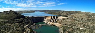
The Gariep Dam is located in South Africa, near the town of Norvalspont, bordering the Free State and Eastern Cape provinces. Its primary purpose is for irrigation, domestic and industrial use as well as for power generation.
The Vanderkloof Dam is situated approximately 130 km (81 mi) downstream from Gariep Dam and is fed by the Orange River, South Africa's largest river. Vanderkloof Dam is the second-largest dam in South Africa, having the highest dam wall in the country at 108 metres (354 ft). The dam was commissioned in 1977; it has a capacity of 3,187.557 million cubic metres (2,584,195 acre⋅ft) and a surface area of 133.43 square kilometres (51.52 sq mi) when full. Other rivers flowing into this dam are the Berg River, two unnamed streams coming in from the direction of Reebokrand, the Knapsak River, Paaiskloofspruit, Seekoei River, Kattegatspruit and the Hondeblaf River, in a clockwise direction.
The Orange–Fish Tunnel, constructed between 1966 and 1975, is an 82.8-kilometre (51.4-mile) long irrigation tunnel in central South Africa, built to divert water from the Orange River to the Fish River valley. It is the longest continuous enclosed aqueduct in the southern hemisphere.
Oviston is a settlement in Walter Sisulu Local Municipality in Joe Gqabi District Municipality in the Eastern Cape province of South Africa.

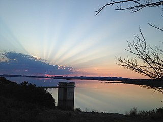
Oviston Nature Reserve is a protected area in the Eastern Cape Province, South Africa. The nature reserve is managed by Eastern Cape Parks. It is located on the southern shores of the Gariep Dam.

Prieska is a town on the south bank of the Orange River, in the province of the Northern Cape, in western South Africa. It is located on the southern bank of the Orange River, 130 km north-west of Britstown and 75 km south-east of Marydale.
Vanderkloof is a town in the Northern Cape province of South Africa. It is located on the Orange River and near the Rolfontein Nature Reserve.
Norvalspont is a small town in Pixley ka Seme District Municipality in the Northern Cape province of South Africa. The name is Afrikaans for Norval’s ferry, and named after an enterprising Scot who constructed a ferry here in 1848. The settlement lies some 40 km east-north-east of Colesberg and 43 km west-north-west of Venterstad, on the southern bank of the Orange River, just below the Gariep Dam.

Venterstad is a settlement in Walter Sisulu Local Municipality in Joe Gqabi District Municipality in the Eastern Cape province of South Africa.


