Related Research Articles

An altimeter or an altitude meter is an instrument used to measure the altitude of an object above a fixed level. The measurement of altitude is called altimetry, which is related to the term bathymetry, the measurement of depth under water.
Atmospheric pressure, also known as air pressure or barometric pressure, is the pressure within the atmosphere of Earth. The standard atmosphere is a unit of pressure defined as 101,325 Pa (1,013.25 hPa), which is equivalent to 1,013.25 millibars, 760 mm Hg, 29.9212 inches Hg, or 14.696 psi. The atm unit is roughly equivalent to the mean sea-level atmospheric pressure on Earth; that is, the Earth's atmospheric pressure at sea level is approximately 1 atm.
Altitude is a distance measurement, usually in the vertical or "up" direction, between a reference datum and a point or object. The exact definition and reference datum varies according to the context. Although the term altitude is commonly used to mean the height above sea level of a location, in geography the term elevation is often preferred for this usage.

Mean sea level is an average surface level of one or more among Earth's coastal bodies of water from which heights such as elevation may be measured. The global MSL is a type of vertical datum – a standardised geodetic datum – that is used, for example, as a chart datum in cartography and marine navigation, or, in aviation, as the standard sea level at which atmospheric pressure is measured to calibrate altitude and, consequently, aircraft flight levels. A common and relatively straightforward mean sea-level standard is instead a long-term average of tide gauge readings at a particular reference location.
Geopotential height or geopotential altitude is a vertical coordinate referenced to Earth's mean sea level that represents the work involved in lifting one unit of mass over one unit of length through a hypothetical space in which the acceleration of gravity is assumed constant. In SI units, a geopotential height difference of one meter implies the vertical transport of a parcel of one kilogram; adopting the standard gravity value, it corresponds to a constant work or potential energy difference of 9.80665 joules.

In aviation and aviation meteorology, a flight level (FL) is an aircraft's altitude at standard air pressure, expressed in hundreds of feet. The air pressure is computed assuming an International Standard Atmosphere pressure of 1013.25 hPa (29.92 inHg) at sea level, and therefore is not necessarily the same as the aircraft's actual altitude, either above sea level or above ground level.
Given an atmospheric pressure measurement, the pressure altitude is the imputed altitude that the International Standard Atmosphere (ISA) model predicts to have the same pressure as the observed value.

The density altitude is the altitude relative to standard atmospheric conditions at which the air density would be equal to the indicated air density at the place of observation. In other words, the density altitude is the air density given as a height above mean sea level. The density altitude can also be considered to be the pressure altitude adjusted for a non-standard temperature.
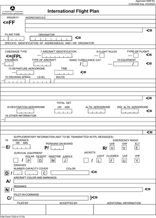
Flight plans are documents filed by a pilot or flight dispatcher with the local Air Navigation Service Provider prior to departure which indicate the plane's planned route or flight path. Flight plan format is specified in ICAO Doc 4444. They generally include basic information such as departure and arrival points, estimated time en route, alternate airports in case of bad weather, type of flight, the pilot's information, number of people on board, and information about the aircraft itself. In most countries, flight plans are required for flights under IFR, but may be optional for flying VFR unless crossing international borders. Flight plans are highly recommended, especially when flying over inhospitable areas such as water, as they provide a way of alerting rescuers if the flight is overdue. In the United States and Canada, when an aircraft is crossing the Air Defense Identification Zone (ADIZ), either an IFR or a special type of VFR flight plan called a DVFR flight plan must be filed. For IFR flights, flight plans are used by air traffic control to initiate tracking and routing services. For VFR flights, their only purpose is to provide needed information should search and rescue operations be required, or for use by air traffic control when flying in a "Special Flight Rules Area."

The elevation of a geographic location is its height above or below a fixed reference point, most commonly a reference geoid, a mathematical model of the Earth's sea level as an equipotential gravitational surface . The term elevation is mainly used when referring to points on the Earth's surface, while altitude or geopotential height is used for points above the surface, such as an aircraft in flight or a spacecraft in orbit, and depth is used for points below the surface.
In aviation, atmospheric sciences and broadcasting, a height above ground level is a height measured with respect to the underlying ground surface. This is as opposed to height above mean sea level, height above ellipsoid, or height above average terrain. In other words, these expressions indicate where the "zero level" or "reference altitude" – the vertical datum – is located.
Inch of mercury is a non-SI unit of measurement for pressure. It is used for barometric pressure in weather reports, refrigeration and aviation in the United States.

Altitude can be determined based on the measurement of atmospheric pressure. The greater the altitude, the lower the pressure. When a barometer is supplied with a nonlinear calibration so as to indicate altitude, the instrument is a type of altimeter called a pressure altimeter or barometric altimeter. A pressure altimeter is the altimeter found in most aircraft, and skydivers use wrist-mounted versions for similar purposes. Hikers and mountain climbers use wrist-mounted or hand-held altimeters, in addition to other navigational tools such as a map, magnetic compass, or GPS receiver.
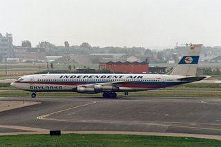
On 8 February 1989, Independent Air Flight 1851, a Boeing 707 on an American charter flight from Bergamo, Italy, to Punta Cana, Dominican Republic, struck Pico Alto while on approach to Santa Maria Airport in the Azores for a scheduled stopover. The aircraft was destroyed, with the loss of all 144 people on board, resulting in the deadliest plane crash in Portugal's history. All of the passengers on board were Italian and all of the crew were Americans. The crash is also known as "The disaster of the Azores".
QFF is an aeronautical code Q code. It is the MSL pressure derived from local meteorological station conditions in accordance with meteorological practice. This is the altimeter setting that is intended to produce correct altitude indication on an altimeter at the actual sea level elevation, while QNH is intended to have no error at the station elevation.

The 1948 Northwood mid-air collision took place on 4 July at 15:03 when a Douglas DC-6 of Scandinavian Airlines System (SAS) and an Avro York C.1 of the Royal Air Force (RAF) collided in mid-air over Northwood in London, UK. All thirty-nine people aboard both aircraft were killed. It was SAS's first fatal aviation accident and was at the time the deadliest civilian aviation accident in the UK. It is still the deadliest mid-air collision in British history.
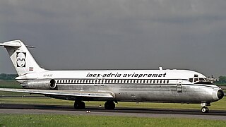
Inex-Adria Aviopromet Flight 450, JP 450, was an international charter flight from Tivat in the Socialist Federal Republic of Yugoslavia to Prague, Czechoslovakia which crashed in the Prague suburb of Suchdol on October 30, 1975, at 09:20 AM. The McDonnell Douglas DC-9-32 with 115 passengers and 5 crew on board descended, under Instrument Meteorological Conditions (IMC), below defined Minimum Descent Altitude (MDA) during the final approach to Prague Ruzyně Airport RWY 25, entered a gorge above Vltava river, and was unable to outclimb the rising terrain. 75 of the 120 occupants died during the crash itself while 4 others died later in hospital. The accident remains the worst aviation disaster on the Czech Republic soil.

Austrian Airlines Flight 901 was a flight from Vienna, Austria to Moscow, USSR via Warsaw, Poland. On the night of 26 September 1960 the aircraft operating the flight, a Vickers Viscount, crashed near Moscow while on its approach to land, killing 31 of the 37 passengers and crew on board.
This is a glossary of acronyms, initialisms and terms used for gliding and soaring. This is a specialized subset of broader aviation, aerospace, and aeronautical terminology. Additional definitions can be found in the FAA Glider Flying Handbook.
Height above mean sea level is a measure of a location's vertical distance in reference to a vertical datum based on a historic mean sea level. In geodesy, it is formalized as orthometric height. The zero level varies in different countries due to different reference points and historic measurement periods. Climate change and other forces can cause sea levels and elevations to vary over time.
References
- ↑ World Meteorological Organization. "Altimeter setting". Eumetcal. Archived from the original on 2016-03-04. Retrieved January 2, 2016.
- ↑ Croucher, Phil (13 December 2015). Avionics In Plain English. Lulu.com. pp. 2–13. ISBN 978-0-9780269-5-0 . Retrieved 28 January 2024.
- ↑ "VFR Manual - Czech Republic". aim.rlp.cz. Retrieved 2024-03-05.