Alto, Texas

Last updated

Alto, Texas
Alto, Texas
Alto, Texas
Alto, Texas
Alto, Texas
Coordinates: 31°39′0″N95°4′26″W / 31.65000°N 95.07389°W / 31.65000; -95.07389
Country United States
State Texas
County Cherokee
Government
  Type Mayor-Council
   City Council Mayor Jimmy Allen
Ell Thacker (Mayor Pro-Term)
Carey Palmer
Jerry Flowers
Steve Cox
Randy Selman
   Chief of Police Jeremy Jackson
Area
[1]
  Total1.71 sq mi (4.42 km2)
  Land1.71 sq mi (4.42 km2)
  Water0.00 sq mi (0.00 km2)
Elevation
436 ft (133 m)
Population
 (2020)
  Total1,027
  Density727.27/sq mi (280.83/km2)
Time zone UTC-6 (Central (CST))
  Summer (DST) UTC-5 (CDT)
ZIP code
75925
Area code 936
FIPS code 48-02188 [2]
GNIS feature ID1372283 [3]
Website cityofalto.com

Alto is a town in Cherokee County, Texas, United States. With a population of 1,027 at the 2020 U.S. census, [4] Alto is the closest municipality to the Caddo Mounds State Historic Site, an archaeological site dating back to 800 BC, featuring a prehistoric village and ceremonial center.

Contents

History

An early settler in the region was Martin Lacy, who built Lacy's Fort just to the west to the current site of Alto in around 1838. In 1838 and 1839, during the campaign to suppress the Córdova Rebellion, the fort served as an operations and supply base for the Third Militia brigade commanded by Maj. Gen. Thomas J. Rusk. [5]

The town of Alto was laid out in 1849 and named for the Spanish word meaning "high," on account of the site's elevation on a drainage divide between the Neches and Angelina Rivers. [6]

Geography

Caddo Mound Site near Alto Caddo Mound Site TX.jpg
Caddo Mound Site near Alto

Alto is located at 31°39′0″N95°4′26″W / 31.65000°N 95.07389°W / 31.65000; -95.07389 (31.650131, –95.073810). [7] According to the United States Census Bureau, the town has a total area of 1.7 square miles (4.4 km2), all land. Alto had a prisoner of war camp during World War II, which served the Cherokee County area.

The climate in this area is characterized by hot, humid summers and generally mild to cool winters. According to the Köppen Climate Classification system, Alto has a humid subtropical climate, abbreviated "Cfa" on climate maps. [8]

Demographics

Historical population
CensusPop.Note
1870 61
1880 8844.3%
1890 210138.6%
1910 672
1920 1,08160.9%
1930 1,053−2.6%
1940 1,1418.4%
1950 1,021−10.5%
1960 869−14.9%
1970 1,04520.3%
1980 1,20315.1%
1990 1,027−14.6%
2000 1,19015.9%
2010 1,2252.9%
2020 1,027−16.2%
U.S. Decennial Census [9]
Alto racial composition as of 2020 [10]
(NH = Non-Hispanic) [lower-alpha 1]
RaceNumberPercentage
White (NH)41640.51%
Black or African American (NH)26826.1%
Native American or Alaska Native (NH)20.19%
Asian (NH)10.1%
Mixed/Multi-Racial (NH)383.7%
Hispanic or Latino 30229.41%
Total1,027

As of the 2020 United States census, there were 1,027 people, 459 households, and 283 families residing in the town.

According to the 2000 U.S. census, there were 1,190 people, 452 households, and 282 families residing in the town. [2] The population density was 707.1 inhabitants per square mile (273.0/km2). There were 534 housing units at an average density of 317.3 per square mile (122.5/km2). The racial makeup of the town was 65.55% White, 24.79% African American, 0.50% Native American, 0.17% Asian, 6.81% from other races, and 2.18% from two or more races. Hispanic or Latino of any race were 10.25% of the population.

Education

Public schools are managed by the Alto Independent School District. These are Alto High School, Alto Middle School, and Alto Elementary School. [12]

Public safety

In 2011, the city eliminated its entire police force after the city council cut the police budget to zero, [13] causing residents to brace for increased crime. [14] A councilman is quoted as saying "The police department, being a non-money-making entity, was the easiest to get rid of." Meanwhile, police services are provided by the county sheriff and, assuming the town's finances improve, it will be opened up again in December. [15]

Notable people

Related Research Articles

<span class="mw-page-title-main">Frankston, Texas</span> Town in Texas, United States

Frankston is a town in Anderson County, Texas, United States. With a population of 1,126 at the 2020 United States census, it is one of the most populous communities of the county area.

<span class="mw-page-title-main">Jourdanton, Texas</span> City in Texas, United States

Jourdanton is a city in and the county seat of Atascosa County, Texas, United States. The population is 4,094. It is part of the San Antonio metropolitan statistical area. The mayor is Robert "Doc" Williams. The city manager is Bobby J. Martinez. The police chief is Eric Kaiser. The fire chief is Jay Fojtik.

<span class="mw-page-title-main">Santa Rosa, Texas</span> Town in Texas, United States

Santa Rosa is a town in Cameron County, Texas, United States. The population was 2,450 at the 2020 census. It is part of the Brownsville–Harlingen–Raymondville and the Matamoros–Brownsville metropolitan areas.

<span class="mw-page-title-main">New Summerfield, Texas</span> City in Texas, United States

New Summerfield is a city in Cherokee County, Texas, United States. The population was 843 at the 2020 U.S. census.

<span class="mw-page-title-main">Coleman, Texas</span> City in Texas, United States

Coleman is a town in and the county seat of Coleman County, Texas, United States. As of the 2010 census, its population was 4,709.

<span class="mw-page-title-main">Crockett, Texas</span> City in Texas, United States

Crockett is a city and the county seat of Houston County, Texas, United States. As of the 2020 census, the city population was 6,332. Houston County is the oldest county and Crockett the fifth-oldest city in Texas.

<span class="mw-page-title-main">Grapeland, Texas</span> City in Texas, United States

Grapeland is a city in Houston County, Texas, United States. Its population was 1,465 as of the 2020 census.

<span class="mw-page-title-main">Lovelady, Texas</span> City in Texas, United States

Lovelady is a town in Houston County, Texas, United States. The population was 570 at the 2020 census.

<span class="mw-page-title-main">Kaufman, Texas</span> Town in Texas, United States

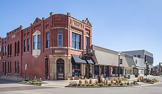
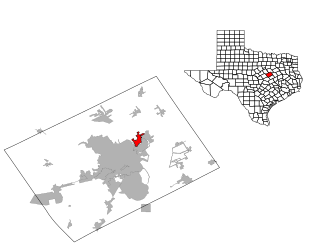
Kaufman is a town in and the county seat of Kaufman County, Texas, United States. Its population was 6,797 at the 2020 census.

<span class="mw-page-title-main">Post Oak Bend City, Texas</span> Town in Texas, United States

Post Oak Bend City is a town in Kaufman County, Texas, United States. Its population was 683 in 2020.

<span class="mw-page-title-main">Terrell, Texas</span> City in Texas, United States

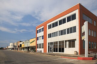
Terrell is a city in the U.S. state of Texas, located in Kaufman County. As of the 2020 census, its population was 17,465. Terrell is located about 32 miles (51 km) east of Dallas.

<span class="mw-page-title-main">Madisonville, Texas</span> City in Texas, United States

Madisonville is a city in Madison County, Texas, United States. The population was 4,420 at the 2020 census. It is the county seat of Madison County. Both the City of Madisonville and the County of Madison were named for U.S. President James Madison, the fourth chief executive.

<span class="mw-page-title-main">Lacy Lakeview, Texas</span> City in Texas, United States

Lacy Lakeview is a city in McLennan County, Texas, United States. It is part of the Waco Metropolitan Statistical Area. The population was 6,988 at the 2020 census. The city's name is sometimes spelled with a hyphen, but the official spelling omits the hyphen.

<span class="mw-page-title-main">Roman Forest, Texas</span> City in Texas, United States

Roman Forest is a city in Montgomery County, Texas, United States. The population was 1,781 at the 2020 census.

<span class="mw-page-title-main">Willow Park, Texas</span> City in Texas, United States

Willow Park is a city in Parker County, Texas, United States. The population was 4,936 in 2020.

<span class="mw-page-title-main">Emory, Texas</span> City in Texas, United States

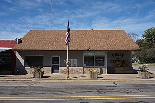
Emory is a city in Rains County, Texas, United States. The population was 1,239 at the 2010 census. It is the county seat of Rains County. Previously known as Springville, the city and county are named after Emory Rains, who was a legislator from the area. Rains was the author of the Homestead Law of Texas, which was later used as a model for the protection of homesteads throughout the United States. Special legislation passed to create Rains County called for the citizens to vote on the location of the county seat and for that selected town to be named Emory.

<span class="mw-page-title-main">Westworth Village, Texas</span> City in Texas, United States

Westworth Village is a city in Tarrant County, Texas, United States. The population was 2,585 at the 2020 census.

<span class="mw-page-title-main">Sanderson, Texas</span> CDP in Texas, United States

Sanderson is a census-designated place (CDP) in and the county seat of Terrell County, Texas, United States. The population was 837 at the 2010 census. Sanderson was created in 1882 as a part of neighboring Pecos County. It became the seat of Terrell County in 1905.

<span class="mw-page-title-main">Oakwood, Texas</span> Town in Texas, United States

Oakwood is a town in Leon and Freestone counties in the U.S. state of Texas. The population was 389 at the 2020 census. It was founded in 1872 as a stop on the International Railroad.

<span class="mw-page-title-main">Waller, Texas</span> City in Texas, United States

Waller is a city in Texas, United States, partly in Waller County and partly in Harris County within the Houston–Cypress metropolitan area. Its population was 2,682 at the 2020 U.S. census. The Waller area is located along U.S. Route 290 41 miles (66 km) northwest of downtown Houston.

References

  1. "2019 U.S. Gazetteer Files". United States Census Bureau. Retrieved August 7, 2020.
  2. 1 2 "U.S. Census website". United States Census Bureau . Retrieved January 31, 2008.
  3. "US Board on Geographic Names". United States Geological Survey. October 25, 2007. Retrieved January 31, 2008.
  4. "Explore Census Data". data.census.gov. Retrieved May 12, 2022.
  5. "Texas State Historical Association" . Retrieved September 16, 2015.
  6. Tarpley, Fred (July 5, 2010). 1001 Texas Place Names. University of Texas Press. p. 8. ISBN   978-0-292-78693-6.
  7. "US Gazetteer files: 2010, 2000, and 1990". United States Census Bureau. February 12, 2011. Retrieved April 23, 2011.
  8. Climate Summary for Alto, Texas
  9. "Census of Population and Housing". Census.gov. Retrieved June 4, 2015.
  10. "Explore Census Data". data.census.gov. Retrieved May 25, 2022.
  11. "About the Hispanic Population and its Origin". www.census.gov. Retrieved May 18, 2022.
  12. "Alto ISD Campuses" Archived December 12, 2008, at the Wayback Machine , Alto Independent School District
  13. "Tiny Texas city lays off entire police force". CBS News. July 5, 2011. Retrieved July 7, 2011.
  14. Ana Campoy (June 29, 2011). "The Day the Law Left Town". Wall Street Journal. Retrieved July 7, 2011.
  15. "Texas Town Dismisses Police Because of Budget Crisis".
  16. Miller, Thomas Lloyd (August 1, 1995). "Biography, George Butler Terrell (1862–1947)". TSHA Online. Austin, TX: Texas State Historical Association. Retrieved May 16, 2021.
  1. Note: the US Census treats Hispanic/Latino as an ethnic category. This table excludes Latinos from the racial categories and assigns them to a separate category. Hispanics/Latinos can be of any race. [11]