Related Research Articles

Van Nuys is a neighborhood in the central San Fernando Valley region of Los Angeles, California. Home to Van Nuys Airport and the Valley Municipal Building, it is the most populous neighborhood in the San Fernando Valley.
Van Nuys Airport is a public airport in the Van Nuys neighborhood of the City of Los Angeles. The airport is operated by Los Angeles World Airports (LAWA), a branch of the Los Angeles city government, that also operates Los Angeles International Airport (LAX). Unlike LAX, Van Nuys has no service from any major airlines, but instead is one of the busiest general aviation airports in the world. The airport's two parallel runways, average over 230,000 takeoffs and landings annually.
Alum Rock is a district of San Jose, California, located in East San Jose. Formerly an independent town, it is now a neighborhood of San Jose, though some portions are still unincorporated as a census-designated place. Alum Rock is one of San Jose's most notable and historic Chicano/Mexican-American districts. It is home to Alum Rock Park, the oldest municipal park in California and one of the largest in the country.

Norman Y. Mineta San Jose International Airport, commonly known simply as San Jose International Airport, is a city-owned public airport in San Jose, California, United States. It is named after San Jose native Norman Mineta, former U.S. Secretary of Transportation and U.S. Secretary of Commerce, who also served as Mayor of San Jose and as a San Jose City Councilman.

Hollywood Burbank Airport, legally and formerly marketed as Bob Hope Airport after entertainer Bob Hope, is a public airport 3 miles (4.8 km) northwest of downtown Burbank, in Los Angeles County, California, United States. The airport serves Downtown Los Angeles and the northern Greater Los Angeles area, which include Glendale, Pasadena, and the San Fernando Valley. It is closer to many popular attractions including Griffith Park, Universal Studios Hollywood, Hollywood, and Downtown Los Angeles than Los Angeles International Airport (LAX), and is the only airport in the area with a direct rail connection to Downtown Los Angeles, with service from two stations: Burbank Airport–North and Burbank Airport–South. Non-stop flights mostly serve cities in the western United States and short-haul international flights to western Canada, while JetBlue has daily flights to New York City.
San Diego International Airport, formerly known as Lindbergh Field, is an international airport three miles (4.8 km) northwest of Downtown San Diego, California, United States. It is owned and operated by the San Diego County Regional Airport Authority. The airport covers 663 acres (268 ha) of land. While primarily serving domestic traffic, San Diego has nonstop international flights to destinations in Canada, Germany, Japan, Mexico, Switzerland, and the United Kingdom.

San Carlos Airport is two miles northeast of San Carlos, California, in San Mateo County, California. The FAA's National Plan of Integrated Airport Systems (NPIAS) classifies San Carlos as a reliever airport for San Francisco International Airport.

Teterboro Airport is a general aviation relief airport in the boroughs of Teterboro, Moonachie, and Hasbrouck Heights in Bergen County, New Jersey. It is owned and managed by the Port Authority of New York and New Jersey and operated by AFCO AvPORTS Management. The airport is in the New Jersey Meadowlands, 12 miles (19 km) from Midtown Manhattan, which makes it popular for private and corporate aircraft. The airport has a weight limit of 100,000 pounds (45,000 kg) on aircraft, making it nonviable as an airline airport.

Alum Rock Park, in the Alum Rock district of San Jose, California, is California's oldest municipal park, established in 1872 but serving as public land since the pueblo was established in 1777. Located in a valley in the Diablo Range foothills on the east side of San Jose, the 720 acre (2.9 km2) park offers 13 miles (21 km) of trails, varying from fairly level along Penitencia Creek to sharp switchbacks climbing to the ridges to the South Rim Trail and the North Rim Trail. The narrow floor of the valley includes a visitor center, a small museum/animal rehab facility, picnic areas, playgrounds, lawns, sand volleyball pits, mineral springs, lush plant life, woodlands, creek play opportunities, and occasional group camping.

East San Jose, commonly called The East Side and less commonly as the East Valley, is the eastern region of the city of San Jose, California. The East Side is made up of numerous neighborhoods grouped into two larger districts: Alum Rock and Evergreen. East San Jose is bordered by the Diablo Range to the east and south, the Coyote Creek to the west, and Mabury Road to the North.

Juan Santamaría International Airport is the primary airport serving San José, the capital of Costa Rica. The airport is located in the city of Alajuela, 20 km west of downtown San José. It is named after Costa Rica's national hero, Juan Santamaría, a drummer boy who died in 1856 defending his country against forces led by US-American filibuster William Walker.

Reid–Hillview Airport of Santa Clara County is in the eastern part of San Jose, in Santa Clara County, California, United States. It is owned by Santa Clara County and is near the Evergreen district of San Jose where aviation pioneer John J. Montgomery experimented with gliders in 1911. Reid–Hillview Airport was also the official general aviation airport for the 2015 Super Bowl in Levi's Stadium.
The Airport/Facility Directory, now identified as Chart Supplement in the U.S., is a pilot's manual that provides comprehensive information on airports, large and small, and other aviation facilities and procedures.

Evergreen, also known as Evergreen Valley, is a large district of San Jose, California, located in East San Jose.

VTA Light Rail is a light rail system in San Jose and nearby cities in Santa Clara County, California. It is operated by the Santa Clara Valley Transportation Authority, or VTA, and consists of 42.2 miles (67.9 km) of network comprising three main lines on standard gauge tracks. Originally opened on December 11, 1987, the light rail system has gradually expanded since then, and currently has 60 light rail stations in operation. VTA operates a fleet of Kinki Sharyo Low Floor Light Rail Vehicles (LFLRV) to service its passengers. The system's average weekday daily ridership as of the end of 2019 is 26,700 passengers and a total annual ridership of 8,335,100 passengers.

Allentown Queen City Municipal Airport is a public airport in Lehigh County, Pennsylvania, on Lehigh Street two miles southwest of Allentown, Pennsylvania. It is owned by the Lehigh-Northampton Airport Authority. Also known as Queen City Airport, it is home to Civil Air Patrol Squadron 805 and Lehigh Valley Aviation Services, a fixed-base operator (FBO).
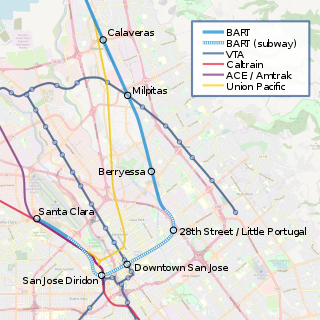
28th Street/Little Portugal station is a proposed underground Bay Area Rapid Transit station in the Little Portugal neighborhood of San Jose, California. It would be located north of East Santa Clara Street between North 28th Street and U.S. Route 101, behind Five Wounds Portuguese National Church. Preceded by the Berryessa/North San Jose BART station, it would be the first station of the Phase II portion of the Silicon Valley BART extension. The station would have direct service to Santa Clara, Richmond, and San Francisco/Daly City. In planning, the station was referred to as Alum Rock/28th Street, after the Alum Rock neighborhood to the northeast.

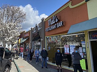
Little Portugal is a historic neighborhood of San Jose, California, and historically the center of the local Portuguese-American community. Little Portugal is home to numerous Portuguese businesses, including Adega, numerous Portuguese social clubs, and the Five Wounds Portuguese National Church.
References
- 1 2 3 Thompson, Judy (October 2006). "An Airport on Alum Rock Avenue? Really? You betcha! Avenue B marks the spot". New Neighborhood Voice. Retrieved 2009-08-10.
- 1 2 "1936 Airport Facility Directory" (JPEG). U.S. Government. 1936. Retrieved 2009-08-10.
- ↑ Thompson, Judy (2006-10-08). "Alum Rock Airport". New Neighborhood Voice. Retrieved 2009-08-10.