The Persians or Iranian Persians are an Iranian ethnic group who comprise over half of the population of Iran. They share a common cultural system and are native speakers of the Persian language as well as of the languages that are closely related to Persian.

Gorgan is a city in the Central District of Gorgan County, Golestan province, Iran, serving as capital of the province, the county, and the district. It lies approximately 400 km (250 mi) to the northeast of the national capital Tehran, and some 30 km (19 mi) away from the Caspian Sea.

Mazandaran Province is one of the 31 provinces of Iran. Its capital is the city of Sari. Located along the southern coast of the Caspian Sea and in the adjacent Central Alborz mountain range, the province is in the central-northern part of the country. Mazandaran, founded in 1937, covers an area of 23,842 km2.

Arash the Archer is a heroic archer-figure of Iranian mythology. According to Iranian folklore, the boundary between Iran and Turan was set by an arrow launched by Arash, after he put his own life in the arrow's launch. The arrow was traveling for days before finally landing on the other side of the Oxus on the bark of a walnut tree hundreds of miles away from the original launch site atop a mountain.

Pāpak Fort or Babak Castle, ″Ghal’eh-e Baz″ is a large citadel on the top of a mountain in the Arasbaran forests, 50 km from Ahar, one parasang from Ardabil, 6 km southwest of Kalibar City in northwestern Iran. According to Ibn al- Nadim, it was the stronghold of Javidhan and Babak Khorramdin, the leaders of the Khurramites in Iranian Azerbaijan who fought the Islamic caliphate of Abbassids. The fort was conquered and ruined by Afshin′s army in 837.

The Farvahar, also known as the Foruhar (فروهر) or the Farre Kiyâni, is one of the best-known symbols of Zoroastrianism. There are various interpretations of what the Faravahar symbolizes, and there is no concrete universal consensus on its meaning. However, it is commonly believed that the Faravahar serves as a Zoroastrian depiction of the fravashi, or personal spirit.

The Khurramites were an Iranian religious and political movement with its roots in the Zoroastrian movement of Mazdakism. An alternative name for the movement is the Muḥammira, a reference to their symbolic red dress.

Matiene was the name of a kingdom in northwestern Iran on the lands of the earlier kingdom of the Mannae. Ancient historians including Strabo, Ptolemy, Herodotus, Polybius, and Pliny mention names such as Mantiane, Martiane, Matiana, Matiani, Matiene, Martuni to designate a region located to the northwest of Media."

Chalus is a city in the Central District of Chalus County, Mazandaran province, Iran, serving as capital of both the county and the district.
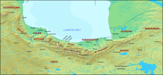
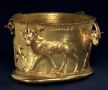
Tabaristan or Tabarestan, was a mountainous region located on the Caspian coast of northern Iran. It corresponded to the present-day province of Mazandaran, which became the predominant name of the area from the 11th-century onwards.

Padishkhwārgar was a Sasanian province in Late Antiquity, which almost corresponded to the present-day provinces of Mazandaran and Gilan. The province bordered Adurbadagan and Balasagan in the west, Gurgan in the east, and Spahan in south. The main cities of the province were Amol and Chalus.

The Twenty-seventh Dynasty of Egypt, also known as the First Egyptian Satrapy, was a province (Satrapy) of the Achaemenid Persian Empire between 525 BC and 404 BC. It was founded by Cambyses II, the King of Persia, after the Battle of Pelusium and the Achaemenid conquest of Egypt, and his subsequent crowning as Pharaoh of Egypt. It was disestablished upon the rebellion and crowning of Amyrtaeus as Pharaoh. A second period of Achaemenid rule in Egypt occurred under the Thirty-first Dynasty of Egypt.
Hamid Algar is a British-American Professor Emeritus of Persian studies at the Faculty of Near Eastern Studies, University of California, Berkeley. He writes on Persian and Arabic literature and contemporary history of Iran, Turkey, the Balkans and Afghanistan. He served on the UC Berkeley faculty for 45 years. Algar remains an active scholar and his research has concentrated on the Islamic history of the Perso-Turkish world, with particular emphasis on Iranian Shi'ism during the past two centuries and the Naqshbandi Sufi order. Algar is a Shia Muslim.

Gīlān is an Iranian province at the southwestern coast of the Caspian Sea. This articles discusses its history.
The Sasanian reconquest of Yemen took place in 575 or 578 after Aksumite men killed Sayf ibn Dhi Yazan after a reign of some four years and took control of Yemen. The rising took place when the protecting Persian garrison withdrew from Yemen. The Sasanians, this time with a force of 4,000 men, managed to reconquer Yemen and install Sayf’s son, Maʿdī Kareb as ruler.

Tapuri or Tapyri were a tribe in the Medes south of the Caspian Sea mentioned by Ptolemy and Arrian. Ctesias refers to the land of Tapuri between the two lands of Cadusii and Hyrcania.
Zangana is a Kurdish tribe in Kermanshah province and some parts of Iraqi Kurdistan. They speak a distinct dialect. However, in recent years they have linguistically assimilated into the language practice of Sorani speakers in the area in which they live.

The defense lines of the Sasanians were part of their military strategy and tactics. They were networks of fortifications, walls, and/or ditches built opposite the territory of the enemies. These defense lines are known from tradition and archaeological evidence.
The Uxii were a tribal confederation of non-Iranian semi-nomadic people who lived somewhere in the Zagros Mountains. They were classified by Nearchus as among the four predatory peoples of the southwest along with the Mardi, Sousii, and Elymaei. They raided the settled people of Iran and raised sheep. The Uxii also tolled passing armies until they were defeated by Alexander the Great at the Battle of the Uxian Defile. After some time, the Uxians regained independence. Some think that the tolling was a gift tradition from the Persian kings to local tribes, and wasn't forced. Greek authors may have misinterpreted the practice or spun it to make Darius look weak. Achaemenid policy on people such as the Uxii involved gift giving and condensing tribal confederations together and then setting up a loyal ruler for that tribe.