Amaroo, Queensland

Last updated

Amaroo
Queensland
Tropic of Capricorn monument, Diamantina Developmental Road, 2016.jpg
Tropic of Capricorn marker on the Diamantina Developmental Road, Amaroo, 2016
Australia Queensland location map.svg
Red pog.svg
Amaroo
Coordinates 23°13′47″S139°22′51″E / 23.2297°S 139.3808°E / -23.2297; 139.3808 Coordinates: 23°13′47″S139°22′51″E / 23.2297°S 139.3808°E / -23.2297; 139.3808
Population22 (2016 census) [1]
 • Density0.00236/km2 (0.00611/sq mi)
Postcode(s) 4829
Area9,325.5 km2 (3,600.6 sq mi)
LGA(s)
State electorate(s) Gregory
Federal division(s)
Suburbs around Amaroo:
Georgina Georgina Wills
Toko Amaroo Wills
Sturt Bedourie Bedourie

Amaroo is an outback locality split between the Shire of Boulia and the Shire of Diamantina, both in Central Western Queensland, Australia. [2] [3] In the 2016 census, Amaroo had a population of 22 people. [1]

Contents

Geography

Amaraoo is a large but largely uninhabited locality in the Channel Country. Rivers like the Georgina River, Burke River, Hamilton River and Sylvester Creek flow through the locality, all of them part of the Lake Eyre basin. [4] These rivers only flow intermittently and, even when they flow, the water usually evaporates before it reaches Lake Eyre. The land is relatively flat so there is no clear single course for these rivers but rather they flow along a series of channels in the same direction (that is, a braided river). [5]

The waterholes that result from the flooding of these rivers sustain both native fauna and support cattle grazing which is the principal land use. [5] [6]

The Boulia Bedourie Road passes through the locality from the north-east (Wills) to the south (Bedourie). The Donohue Highway passes through the locality from the west (Toko) to the north-east (Wills) [4]

The Tropic of Capricorn passes from east to west through the locality. [4]

The entire locality is within the Marian Downs cattle station, which being 12,870 square kilometres (4,970 sq mi) also extends into some neighbouring localities. [4] As at 2017, the property is the largest of 14 cattle stations owned by the North Australian Pastoral Company (NAPCO). [7] [8] The homestead is located at 23°22′00″S139°39′00″E / 23.3667°S 139.65°E / -23.3667; 139.65 (Marion Downs homestead) approx 2.7 kilometres (1.7 mi) west of the Boulia Bedourie Road. [9]

History

The locality takes its name from Lake Amaroo, which in turn derives its name from the Kogai word "Amu" meaning water. [2] [3] [10]

NAPCO purchased Marion Downs in 1934. [8]

In the 2016 census, Amaroo had a population of 22 people. [1]

Education

There are no schools in Amaroo. The nearest primary schools are in Boulia and Bedourie. [11] The nearest secondary schools are in Mount Isa, Winton and Longreach and too far for a daily commute. [11] The Spinifex State College in Mount Isa offers boarding facilities. [12] Furthermore, other boarding schools or distance education would also be options for students.

Related Research Articles

<span class="mw-page-title-main">Boulia, Queensland</span> Town in Queensland, Australia

Boulia is an outback town and locality in the Shire of Boulia, Queensland, Australia. In the 2016 census, Boulia had a population of 301 people.

<span class="mw-page-title-main">Bedourie, Queensland</span> Town in Queensland, Australia

Bedourie is a town and a locality in the Shire of Diamantina, Queensland, Australia. In the 2016 census, Bedourie had a population of 122 people.

<span class="mw-page-title-main">Birdsville</span> Town in Queensland, Australia

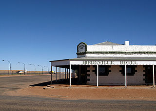
Birdsville is a rural town and locality in the Shire of Diamantina, Queensland, Australia. In the 2021 census the locality of Birdsville had a population of 110 people. It is a popular tourist destination with many people using it as a starting point across the Simpson Desert.

<span class="mw-page-title-main">Thargomindah</span> Town in Queensland, Australia

Thargomindah is a rural town and locality in the Shire of Bulloo, Queensland, Australia. The town of Thargomindah is the administrative centre for the Shire of Bulloo. In the 2016 census, Thargomindah had a population of 270 people. It was founded on Wongkumara and Kalali territory.

<span class="mw-page-title-main">Channel Country</span> Bioegion in Australia

The Channel Country is a region of outback Australia mostly in the state of Queensland but also in parts of South Australia, Northern Territory and New South Wales. The name comes from the numerous intertwined rivulets that cross the region, which cover 150,000 km². The Channel Country is over the Cooper and Eromanga geological basins and the Lake Eyre Basin drainage basin. Further to the east is the less arid Maranoa district.

<span class="mw-page-title-main">Gregory, Queensland</span> Town in Queensland, Australia

Gregory is an outback town and locality in the Shire of Burke, Queensland, Australia. In the 2016 census, the locality of Gregory had a population of 72 people.

<span class="mw-page-title-main">Central West Queensland</span> Region in Queensland, Australia

Central West Queensland is a remote region in the Australian state of Queensland which covers 396,650.2 km2. The region lies to the north of South West Queensland and south of the Gulf Country. It has a population of approximately 12,387 people.

Glenormiston Station, commonly known as Glenormiston, is a pastoral lease that operates as a cattle station in Queensland, Australia.

<span class="mw-page-title-main">Coorabulka</span> Rural Australian cattle station

Coorabulka Station most commonly known as Coorabulka is a pastoral lease that operates as a cattle station in Queensland, Australia.

For the former Cattle station in the Kimberley region of Western Australia, see Marion Downs Sanctuary

Diamantina Lakes Station most commonly known as Diamantina Lakes was a pastoral lease that once operated as a cattle station in central west Queensland, and is now Diamantina National Park a national park.

<span class="mw-page-title-main">Glengyle Station</span>

Glengyle Station most commonly known as Glengyle is a pastoral lease that operates as a cattle station in central west Queensland.

<span class="mw-page-title-main">Durrie Station</span>

Durrie Station most commonly referred to as Durrie is a pastoral lease that operates as a cattle station in Queensland.

<span class="mw-page-title-main">Kidman's Tree of Knowledge</span> Historic site in Queensland, Australia

Kidman's Tree of Knowledge is a heritage-listed tree at Glengyle Station, Bedourie, Shire of Diamantina, Queensland, Australia. It is also known as Tree of Knowledge. It was added to the Queensland Heritage Register on 21 October 1992.

Farrars Creek is a rural locality in the Shire of Barcoo, Queensland, Australia. In the 2016 census, Farrars Creek had a population of 0 people.

Carrandotta is a locality in the Shire of Boulia, Queensland, Australia. In the 2016 census, Carrandotta had a population of 0 people.

Piturie is an outback locality in the Shire of Boulia, Queensland, Australia. In the 2016 census, Piturie had a population of 59 people. The town of Urandangi is within the locality.

Sturt is an outback locality split between the Shire of Boulia and in the Shire of Diamantina, both in Queensland, Australia. In the 2016 census, Sturt had a population of 0 people.

Wills is an outback locality in the Shire of Boulia, Queensland, Australia. In the 2016 census, Wills had a population of 14 people.

Mantuan Downs is a rural locality in the Central Highlands Region, Queensland, Australia. In the 2016 census Mantuan Downs had a population of 31 people.

References

  1. 1 2 3 Australian Bureau of Statistics (27 June 2017). "Amaroo (SSC)". 2016 Census QuickStats. Retrieved 20 October 2018. OOjs UI icon edit-ltr-progressive.svg
  2. 1 2 "Amaroo – locality in Shire of Boulia (entry 42338)". Queensland Place Names. Queensland Government . Retrieved 14 December 2018.
  3. 1 2 "Amaroo – locality in Shire of Diamantina (entry 41497)". Queensland Place Names. Queensland Government . Retrieved 14 December 2018.
  4. 1 2 3 4 "Queensland Globe". State of Queensland . Retrieved 13 December 2018.
  5. 1 2 "Channel Country". Queensland Places. Centre for the Government of Queensland, University of Queensland. Archived from the original on 20 October 2018. Retrieved 13 December 2018.
  6. "Channel Country". Queensland Historical Atlas. University of Queensland. Archived from the original on 13 December 2018. Retrieved 14 December 2018.
  7. "Our stations". North Australian Pastoral Company. 2017. Archived from the original on 13 December 2018. Retrieved 14 December 2018.
  8. 1 2 "Marion Downs". North Australian Pastoral Company. 2017. Archived from the original on 13 December 2018. Retrieved 14 December 2018.
  9. "Marion Downs – homestead in Shire of Boulia (entry 20999)". Queensland Place Names. Queensland Government . Retrieved 14 December 2018.
  10. "Lake Amaroo – lake in Shire of Boulia (entry 501)". Queensland Place Names. Queensland Government . Retrieved 14 December 2018.
  11. 1 2 "Queensland Globe". State of Queensland . Retrieved 15 August 2019.
  12. "Residential Campus" (PDF). Spinifex State College . 2015. Archived (PDF) from the original on 15 August 2019. Retrieved 15 August 2019.

Commons-logo.svg Media related to Amaroo, Queensland at Wikimedia Commons