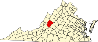
Rockbridge County is a county in the Shenandoah Valley on the western edge of the Commonwealth of Virginia. As of the 2020 census, the population was 22,650. Its county seat is the city of Lexington. Rockbridge County completely surrounds the independent cities of Buena Vista and Lexington. The Bureau of Economic Analysis combines the independent cities of Buena Vista and Lexington with Rockbridge County for statistical purposes.

Lexington is an independent city in Virginia, United States. At the 2020 census, the population was 7,320. It is the county seat of Rockbridge County, although the two are separate jurisdictions, and is combined with it for statistical purposes by the Bureau of Economic Analysis. Lexington is about 57 miles (92 km) east of the West Virginia border and is about 50 miles (80 km) north of Roanoke, Virginia. First settled in 1778, Lexington is best known as the home of the Virginia Military Institute and Washington and Lee University.

Buena Vista is an independent city located in the Blue Ridge Mountains region of Virginia in the United States. As of the 2020 census, the population was 6,641. The Bureau of Economic Analysis combines the independent cities of Buena Vista and Lexington, along with surrounding Rockbridge County, for statistical purposes.

Goshen is a town in Rockbridge County, Virginia, United States. The population was 361 in the 2010 census.

Natural Bridge is a geological formation in Rockbridge County, Virginia, comprising a 215-foot-high (66 m) natural arch with a span of 90 feet (27 m). It is situated within a gorge carved from the surrounding mountainous limestone terrain by Cedar Creek, a small tributary of the James River. Consisting of horizontal limestone strata, Natural Bridge is the remains of the roof of a cave or tunnel through which the Cedar Creek once flowed.
Natural Bridge is an unincorporated community in Rockbridge County, Virginia, United States. The community is the site of Natural Bridge, a natural arch which gives the town its name. Natural Bridge is located at the junction of U.S. Route 11 and State Route 130. Natural Bridge has a post office with ZIP code 24578, which opened on June 1, 1800.

Buildings, sites, districts, and objects in Virginia listed on the National Register of Historic Places:

The Cyrus McCormick Farm and Workshop is on the family farm of inventor Cyrus Hall McCormick known as Walnut Grove. Cyrus Hall McCormick improved and patented the mechanical reaper, which eventually led to the creation of the combine harvester. The farm is near Steele's Tavern and Raphine, close to the northern border of Rockbridge and Augusta counties in the U.S. state of Virginia, and is currently a museum run by the Virginia Agricultural Experimental Station of Virginia Tech. The museum has free admission and covers 5 acres (2.0 ha) of the initial 532-acre (215.3 ha) farm.
This is a list of the National Register of Historic Places listings in Rockbridge County, Virginia.

This is a list of the National Register of Historic Places listings in Lexington, Virginia.

This is a list of the National Register of Historic Places listings in Buena Vista, Virginia.
Hickory Hill is a historic estate in Rockbridge County, Virginia.

The Cedar Hill Church and Cemeteries are located in historic Rockbridge County, Virginia. The small log church, which also served as a schoolhouse, was built in 1874 evoking the history of Rockbridge County's African American community. The land was given by a white farmer named John Replogle and transferred to” Trustees for the Colored Baptist Congregation” A cemetery was established behind the church, marked today by a scattering of field stone memorials. Because of the rocky ground, a new cemetery was laid out at a separate location around 1890 and is still in use. The Cedar Hill congregation was formed shortly after the Civil War. It consisted of African Americans that basically worked and lived on white-owned farms. The meetings were held in a log dwelling southwest of the present church. Later, the congregation met under a large oak tree that stood approximately one and a half miles west of the present church. Cedar Hill's oak tree meeting-place was similar to the brush arbor churches that many freedman congregations established in Virginia following the Civil war as temporary shelter. It is said that many members were buried near that oak tree that was called as the "Gospel Tree". The tree was destroyed by lightning around 1890, but the stump is still visible and a limb from it is kept at the present church as a historic memento.

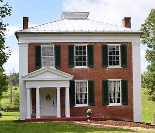
Mulberry Grove is a historic home located near Brownsburg, Rockbridge County, Virginia. The original section was built about 1790, and later expanded in the 1820s to a two-story, three bay, brick and frame Federal style dwelling. It has a side gable roof and two chimneys at the northeast end and one brick chimney near the southwest end. A frame stair hall was added about 1828 and brick wings were added at each end about 1840. The property includes a contributing log meat house and a double-pen log barn. The house was built for William Houston, a relative of the Texas pioneer and Rockbridge County native, Sam Houston.

Rockbridge Alum Springs Historic District, also known as Jordan Alum Springs, and now known as Rockbridge Alum Springs - A Young Life Camp, is a historic 19th-century resort complex and national historic district near California, Rockbridge County, Virginia, United States. The district encompasses 16 contributing buildings, 10 contributing sites, and 4 contributing structures dating primarily to the 1850s, and associated with the operations of the Rockbridge Alum Springs, a popular 19th- and early-20th century mountain resort. The buildings are the barroom, store/post office, Montgomery Hall, the Gothic Building, the Alum Springs Pavilion, two cottages of Baltimore Row, the Ladies Hotel, four cottages of Kentucky Row, Jordan's House, a servant's quarters, a slave quarters, and a storehouse. The remaining structures are a well and the stone spring chambers and gazebo and bandstand of the Jordan Alum Springs. The sites are primarily those of demolished cottages. It is one of the best-preserved antebellum springs resort complexes in Virginia. The resort remained in operation until 1941. It is currently owned and operated by Young Life, a non-denominational Christian youth organization, and has been operated as a year-round campground since 1992.

The Liberty Hall Site, near Lexington, Virginia, contains the remains of the early predecessor of Washington and Lee University. The Liberty Hall Academy was chartered as a degree-granting institution by the Virginia legislature in 1782, and was located in a wood-frame building. This building burned down in 1783, as did its replacement in 1790. In 1793 a new three-story stone building was constructed, as was a steward's house, and these buildings were followed in subsequent years by additional buildings. The roof of the main school building caught fire in 1802, and the ensuing blaze gutted the building's interior. It was declared unfit to restore, and the institution relocated into Lexington.

Haines Chapel, together with the South Mountain Cemetery, is a historic property located near the Blue Ridge Parkway in Rockbridge and Nelson Counties in the U.S. state of Virginia. The site is located just west of the parkway and north of Virginia Route 56. The cemetery apparently began as a family cemetery in the 18th century; its oldest dated grave marker is a modern one dated 1793, although the oldest legible stone gives a date of 1857. The chapel, a simple wood-frame building constructed in 1914, stands on the Nelson County side of the property. Its interior contains well-preserved period woodwork, and is largely in original condition, including a period piano and organ. It is still used occasionally for services and special occasions, and the cemetery is also open to new burials.

The Scott-Hutton Farm is a historic farm property at 1892 Turnpike Road in rural Rockbridge County, Virginia, west of Lexington. The farm property includes an early 19th-century farmhouse, to which an older log structure is appended, an early 19th-century springhouse, and several late 19th and 20th-century outbuildings. The house features fine Greek Revival styling, part of an 1843 enlargement. The early settlers were William and Ann Scott, who came to the area in 1802, and the Greek Revival alterations were made by James Hutton after he purchased the property.
Collierstown is an unincorporated community in Rockbridge County, Virginia, United States. Collierstown is located in the 540 area code. As of 2023, there are 654 registered voters in the area.


