Angoche

Last updated

Angoche is a district, city and municipality located in Nampula Province in north-eastern Mozambique. The district has limits in the North with Mogincual District, in the South with Larde District, to the east with the Indian Ocean and to the west with Mogovolas District. The principal town is Angoche. It is located 185 km from the provincial capital, Nampula City.

Contents

Angoche
Parapatho
City, Municipality and District
Angoche District in Mozambique 2018.svg
Location in Mozambique
Coordinates: 15°52′09″S39°55′00″E / 15.86917°S 39.91667°E / -15.86917; 39.91667
CountryFlag of Mozambique.svg  Mozambique
Province Nampula
CapitalAngoche
Government
  BodyDistrict Administration
Area
  Total3,056 km2 (1,180 sq mi)
Elevation
12 m (39 ft)
Population
 (2017)
  Total347,175
  Density101.8/km2 (264/sq mi)
Ethnic Groups
  Makhuwa40%
   Koti 60%
Languages
   EMakhuwa 40 %
   Koti 60%
Time zone UTC+2 (Central Africa Time)

History

Arab Explorers

Before the arrival of Vasco de Gama in 1498, and according to local oral tradition, the Archipelago of Angoche, made up of several islands, was inhabited by a community that was part of the Swahili, on the East African coast. The dominant groups in the region, the Anhapakhos, were members of the Shiraz family, which allegedly reached the islands of Angoche and Quiloa Island (in present-day Tanzania) whose sultans were also Shirazis, originating from the port of Shiraz, located on the Persian side of the Persian Gulf. One of the founders of the reigning family of the Sultanate of Angoche was Hasani, who died at sea and was buried on the island that was later named after him, Kisiwa Sultani Hasani (known as Ilha de Mafamede by the Portuguese). According to Duarte Barbosa, who wrote in 1508, the habits, customs and language of the inhabitants of the islands of Angoche were similar to those of the Ilha de Moçambique.

At the time of the arrival of the first islamic explorers, whom the Portuguese called “Moors”, the Marundos peoples, descendants of the Amacúas, already inhabited the lands of Angoche. According to oral accounts, this people had already been constituted before the first Bantu incursion. The story goes that two important men with the names Mussa and Hassan, accompanied by their relatives and slaves, left Zanzibar following religious differences and headed for and settled in Ilha de Moçambique. One day, Hassan, intending to reach the mainland of Mozambique, in the Angoche Bay region, was surprised by a strong storm, ending up losing his life when he fell into the sea. Hassan was buried in the nearest place which was the Mafamede island. Notifying Mussa of Hassan's death, he went to the site to see Hassan's tomb, having boarded the village of Mialule, now Melule. Arrived at Mafamede where Hassan had been buried and, having Mussa liked the place, there he left his son Xosa who chose Muchelele, a place close to Hassan's tomb, to establish his residence and where he started to govern with the title of Sultan. (See Angoche Sultanate for more information.) They are some of Xosa's children who give rise to the population of Catamoio which, in turn, gives rise to the Village of Angoche.

Portuguese Colonial and Occupation Resistance

In 1863, the land was conquered from the Portuguese by Sultan Mussa, supported by slave traders. Until the mid-19th century, the Portuguese were unable to control or settle on the islands or mainland of Angoche. The situation changed when one of the members of the royal family of the Angoche Islands, Mussa Mohammad Sahib Quanto (d. 1879), decided to attack the deadlines of Macanja da Costa, belonging to the Silva brothers, because of the dispute over the control of the roads of flow of slaves from the interior to the coast.

The Portuguese went to support the da Silvas and a small military detachment of about twenty elements came to occupy the island in 1861, together with João Bonifácio da Silva, one of the Silva brothers. The pleasure people, after taking revenge on the Anhapakhos, had no interest in settling on the islands and returned to their land. Consequently, Mussa Quanto recovered the island, where he was installed as sultan and the few Portuguese present were expelled. From the beginning of the "effective occupation" of Africa, which had a decisive start in 1895, the islands of Angoche suffered repeated assaults by the Portuguese. Then the other member of the Angoche royal family, Omar bin Nacogo Farallahi (known as Farelay by the Portuguese), along with Sultan Ibrahim and his allies, the mainland Macuas, led the resistance that lasted until 1910, when Massano de Amorim and other Portuguese officers managed to conquer the region militarily.

After taking the island in 1861, the Portuguese created the modern settlement (decree dated 05.07.1865), whose charter was approved in the mid-twentieth century (Ordinance No. 11.585 of 04.08.1956, when the town was supplied with water). The evolution of the administrative process of Angoche then went through the following stages throughout the 19th century: seat of circumscription on July 30, 1921, and county seat on October 31, 1934; it elevated the village on December 19, 1934 and the city on September 26, 1970. Although the Portuguese continued to administer the region from one of the islands of Angoche (Quiloa), there was already a small Portuguese population in Parapato, in part mainland.

From the beginning of the 1930s, at the time of the Estado Novo, the mainland Angoche region became one of the centers of cashew and rice production, in addition to traditional fishing, which already existed on the coast. The Portuguese identified the Puli area, where the Africans lived, as the best continental part of Parapato. Consequently, the Africans were resettled in the Bairro de Inguri, created at this time, and in Puli the European masonry village called + was built. The urban evolution can be followed through the municipal edition Planta da Vila de António Enes (esc. 1/5,000), dated 1958, in which the elementary grid that makes up the town on the coast is drawn. The 20th century urbanization plans or studies date from 1924, 1932 and 1965 (the latter being authored by the architect Bernardino Ramalhete and revised by Hidrotécnica Portuguesa in 1972). In 1968 and 1972, the colonial government, concerned about the spread of liberation movements in northern Mozambique, carried out several measures aimed at winning Muslims to its side, although many of them were also related to the policies of decentralization of the Portuguese government from 1971, which allowed the channeling of new funds to the colonies. This resulted in an improvement in the quality of life of the African population, including basic sanitation and the construction of masonry neighborhoods for Africans, including the Bairro de Inguri, in the city of Angoche. At the same time, the Portuguese government restored some important historic mosques and built new ones, such as the Mosque of Catamoio, on one of the islands of Angoche, inaugurated by General Kaúlza de Arriaga in 1971. Monuments and Statues The Monument to António is highlighted Enes, simple bust on a pedestal, in front of the City Hall (built before 1954). It was built as a "homage to the population of the county", as one could read in the inscription on its base, which consists of a prismatic stone volume with two buttresses, also in stone, on each side.

Angoche was one of the most important socio-economic centers in the region. With the proclamation of National Independence, in February 1976, the city of António Enes was renamed Angoche. In 1997 the city is elevated to the category of City Municipality, under Law 10/97 of 31 May.

Geography

Neighboring Districts

Angoche District is limited by:

Climate and Geomorphology

The south eastern Nampula towards the northern coastal region of Zambézia, including the coastal districts of Angoche, Larde, Moma and Pebane, the average annual rainfall returns to values between 800 and 1,000 mm, although the potential evapotranspiration is higher than the 1,500 mm. The temperature is generally above 20 °C.

Climate data for Angoche
MonthJanFebMarAprMayJunJulAugSepOctNovDecYear
Mean daily maximum °F (°C)86
(30)
86
(30)
84
(29)
82
(28)
81
(27)
79
(26)
79
(26)
81
(27)
86
(30)
90
(32)
90
(32)
90
(32)
84
(29)
Mean daily minimum °F (°C)75
(24)
73
(23)
72
(22)
72
(22)
68
(20)
66
(19)
64
(18)
66
(19)
68
(20)
70
(21)
73
(23)
75
(24)
70
(21)
Average precipitation inches (mm)5.1
(130)
4.5
(114)
3.4
(86)
1.5
(38)
0.7
(17)
0.6
(15)
0.6
(14)
0.5
(12)
0.2
(5)
0.2
(6)
0.7
(17)
2.4
(60)
20.2
(514)
Source: Meteoblue [1]

The coastal plains in the region are dissected by some rivers that ascend from the coast to the interior, gradually passing to a more dissected relief with more steep slopes in between, from the transitional subplateau zone to the coastal zone. This zone corresponds to the coastal area of the province. It is characterized by its sandy soils, washed to moderately washed, predominantly yellow to greyish-brown, whether in the inland sandy cover (Ferralic Arenosols) or in the coastal sandy dunes (Haplic Arenosols), and also by the soils of the strip of coastal sandstone, from sandy to loam sandy clay loam with orange color (Ferralic Arenosols). The hydromorphic sandy soils of depressions and lows alternate with the higher ground parts (Gleyic Arenosols).

Demographics

The following statistics are from the 2017 census.

Population and Density

In the 2017 census [2] the population has increased to 341,176 with the rise of density to 101.8 inhabitants per km².

In 2007, the Census indicated total population of 276 471 residents. The population density was around 92.59 inhabitants per km². [3] According to the 1997 Census, the district had 228,526 inhabitants, resulting in a population density of 76.5 inhabitants per km².

Gender

GenderPopulation%
Female168,45251.50%
Male178,72448.50%

Administrative and political units

Subdivisions

The Angoche district is divided into four administrative posts: Angoche, Aube, Boila-Nametoria and Namaponda. These posts are, in turn, composed of the following localities.

Administrative PostLocalities
Angoche-SedeAngoche
AúbeAube

Catamoio

Boila-NamitoriaBoila

Nabruma

Malapa

NamapondaNamaponda

Political leadership / Government

The district government is represented by an Administrator, which is the highest local government rank. Since 1975, 9 District Administrators have been appointed by different Mozambique Presidents:

Economy

Agriculture, Livestock and Fishery

Agriculture is one of the most dominant activity in Angoche and involves almost all households. In general, agriculture is practiced manually on a small scale farms or family farms.

The farm plantation mechanism is based on the intercropping of local crops. Agricultural production is predominantly done under rainfed conditions, not always successful, as the risk of crop loss is high, given the low moisture storage capacity in the soil during the growing period of the crops. There are also small irrigation infrastructures with the capacity to carry out surface irrigation and dams with the potential to irrigate small agricultural areas. The coastal strip is dominated by the production system based on the cultivation of cassava, intercropped with grain legumes such as cowpea and peanut. Upland rice is the crop produced in the alluvial plains of the main rivers that drain the coast and estuarine plains, and is normally produced in floodplains prepared for this purpose.

It is also worth mentioning the importance of coconut and cashew trees in the coastal zone's production system, either as a product that guarantees food security or as a source of income for rural families. The cashew agroforestry system is the most representative, even becoming dominant. The most important intercropping of cashew, comprises crops such as cassava and corn, following the traditional pattern of rotation and fallow in the medium and long term, depending heavily on the age of the cashew trees and their productivity. A peculiarity of the area is that practically all the cassava is within the cashew tree area. The coconut palm in the province has a wide distribution towards the interior. It was only in 2003, after the period of drought and drought that followed and the rehabilitation of some infrastructures, that farming in the district was timidly restarted and production levels recovered. Livestock promotion in the district has been weak. However, given the tradition in raising cattle and some existing infrastructure, there was some growth in the livestock population.

Due to limited investing and financing mechanism the livestock is not well developed, although the existence of pasture areas. Lack of extension services is also one of the main obstacles to its development.

Mangrove trees are used for firewood and building material. The district is struggling with erosion problems. Wildlife is an important food supplement for local families. Among the most hunted species are rabbits, gazelles and guinea fowl. In addition to the species already mentioned, the wildlife in the district also includes antelopes and monkeys.

Fishing in the district is more focused on shrimp, to the detriment of other species and valuable resources consisting of lobster, squid, octopus and crab. There are two fishing companies in the district, Pesca Norte and Mawipi Pescas.

Commerce. Industries And Tourism

The Angoche district already had a very important agro-industry activity. Today, of the 12 companies in the district's industrial park, only 3 are operational. The small local industry (fishing, carpentry and handicraft) appears as an alternative to agricultural activity, or extension of its activity. The district has a total of 22 small industries. The district has access to an extensive network of markets, due to its road links with Nampula and the Nacala corridor, and the existence of the port in Angoche. Traders from Nampula, Cabo Delgado and Tanzania come to the district to buy local products. The district has excellent areas for tourism, including the following: Praia Nova, 7 km from the city of Angoche; Monte Parapato, Praia da Rocha, Quelelene Island, Mafamede Island, among others. Other local attractions to mention are the Municipal Cemetery, Campo do Sultão Hassane Yossufo, the Cadeia Civil Building, the Sangaje lighthouse and the Luís de Gonzaga Church in Malatane.

Mineral Resources

Like other districts in the country, Angoche has enormous potential in different types of mineral resources, among others. Since colonial times, Angoche has been the target of prospecting, research and geological mapping programs in order to identify its potential.

According to the geological studies, Angoche has huge quantities of heavy (Zircon, Ilmenite, Rutile , titanium) minerals deposits along of its coastal plain. This mineral are currently been explored by a consortium of companies from China, Ireland and the United States. And as per mining catalogue [8] (2021), except 1 for the limestone exploration license, most of them (16) are designated for heavy mineral exploration. Although there are many companies in exploration and licensing phase, its importante to mention one of the key players exploring and producing the heavy sands in Angoche district are Kenmare Resources (An Irish-American Enterprise), África Great Wall Mining Development Co [9] [10] [11] [12] (Chinese), a subsidiary of Hainan Haiyu Mining Co. Ltd.

Oil and Gas

Following the public tender launched by INP in October 2014, for the concession of areas for exploration and production of hydrocarbons, 2 offshore blocks was awarded in October 2018 to multinational oil companies. Area A5-A awarded to a consortium led by Eni 34.5%(Italy), in partnership with, Sasol 25.5%(South Africa), QatarEnergy 25.5% (Qatar) and National Oil Company ENH 15% (Mozambique); while the deeper Area A5-B was awarded to ExxonMobil 40% (USA), Roseneft 20%(Russia), QatarEnergy 10% (Qatar), Eni 10% (Italy), and National Oil Company ENH 20% (Mozambique). [13] [14] Along the 8 years of exploration period, the companies are obliged to implement exploration programs with consists of shooting 3D seismic surveys of 8,000 km2 from each area and undertake at least 1 exploration drilling activities in each area before any surrender and abandonment. [15] [16] According to local authorities, the preliminary studies indicate that the offshore Angoche is an oil-pron province, for this reason the local communities, provincial and central government is very positive about the project. [17] [18] [19]

In 2019, both Eni and ExxonMobil along with environmental consulting companies have visited the districts and neighboring regions in order to fulfil all the requirements for environmental permit [20] [21] for drilling activities to take place in Q1 2022. [22] [23]

Sustainability

Firewood and charcoal are the most used energy sources.

Further reading

Related Research Articles

<span class="mw-page-title-main">Mozambique</span> Country in Southeastern Africa

Mozambique, officially the Republic of Mozambique, is a country located in southeastern Africa bordered by the Indian Ocean to the east, Tanzania to the north, Malawi and Zambia to the northwest, Zimbabwe to the west, and Eswatini and South Africa to the southwest. The sovereign state is separated from the Comoros, Mayotte and Madagascar by the Mozambique Channel to the east. The capital and largest city is Maputo.

<span class="mw-page-title-main">Portuguese Mozambique</span> 1505–1975 Portuguese possession in East Africa

Portuguese Mozambique or Portuguese East Africa were the common terms by which Mozambique was designated during the period in which it was a Portuguese colony. Portuguese Mozambique originally constituted a string of Portuguese possessions along the south-east African coast, and later became a unified colony, which now forms the Republic of Mozambique.

<span class="mw-page-title-main">Zambezia Province</span> Province of Mozambique

Zambezia is the second most-populous province of Mozambique, located in the central coastal region south-west of Nampula Province and north-east of Sofala Province. It has a population of 5.11 million, according to the 2017 census. The provincial capital is Quelimane.

<span class="mw-page-title-main">Nampula Province</span> Province of Mozambique

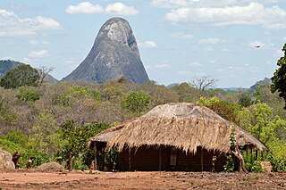
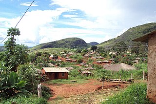
Nampula is a province of northern Mozambique. It has an area of 79,010 km2 (30,510 sq mi) and a population of 5,758,920, making it the most populous province in Mozambique. Nampula is the capital of the province.

<span class="mw-page-title-main">Nampula</span> City in Nampula Province, Mozambique

Nampula is the capital city of Nampula Province in Northern Mozambique. With a population of 743,125, it is the third-largest city in Mozambique after Maputo and Matola. The city is located in the interior of Nampula Province, approximately 200 kilometers from the coast and is surrounded by plains and rocky outcrops. The city is a major regional centre for the entire Northern region of Mozambique, as well as parts of Central Mozambique and border areas of Malawi and Tanzania.

<span class="mw-page-title-main">Beira, Mozambique</span> Place in Sofala Province, Mozambique

Beira is the capital and largest city of Sofala Province, where the Pungwe River meets the Indian Ocean, in the central region of Mozambique. It is the fourth-largest city by population in Mozambique, after Maputo, Matola and Nampula. Beira had a population of 397,368 in 1997, which grew to 530,604 in 2019. A coastal city, it holds the regionally significant Port of Beira, which acts as a gateway for both the central interior portion of the country as well as the land-locked nations of Zimbabwe, Zambia and Malawi.

<span class="mw-page-title-main">Angoche Island</span>

Angoche Island is a small island in the district of same name in Mozambique. The island lies at the mouth of the Mluli River; the river enters the sea at the southernmost point of a large bay which contains a number of low, marshy islands. One of these islands was home to the ancient Islamic settlement of Angoche, and the island is thus known as Angoche Island.Being a coastal island its main source of income was the illegal shipment of slaves, which allowed for the enrichment of the aristocratic classes of the Nyapakho clan. It was not taken by the Portuguese until 1913, thanks to the brave resistance of the sultan, particularly Ibrahim Iussuf. His nephew, who was the commander-in-chief of a 30,000 men army took over power and opposed with tenacity the Portuguese until 1890. By then, Farlah, the last sultan resumed the war against the Portuguese until he was captured in a battle in 1910 and deported to East Timor where he died in prison. The small island is subject to cyclones; Cyclone Huda in particular is remembered, and so permanent habitation has not been possible. Angoche is the largest producer of cashew and shrimps in Mozambique.

<span class="mw-page-title-main">Island of Mozambique</span> Historically significant island off the northeastern coast of Mozambique

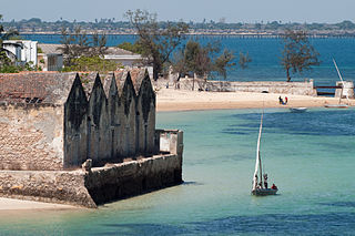
The Island of Mozambique lies off northern Mozambique, between the Mozambique Channel and Mossuril Bay, and is part of Nampula Province. Prior to 1898, it was the capital of colonial Portuguese East Africa. With its rich history and sandy beaches, the Island of Mozambique is a UNESCO World Heritage Site and one of Mozambique's fastest-growing tourist destinations. It has a permanent population of approximately 14,000 people and is served by nearby Lumbo Airport on the Nampula mainland. The name of the country, Mozambique, is derived from the name of this island.

<span class="mw-page-title-main">Angoche Sultanate</span>

The Angoche Sultanate was established in 1485 along an archipelago off the Northern Mozambique coastline. Centered on the cities of Angoche and Moma, the Sultanate also had a number of vassal territories surrounding them. They were finally removed from power by the Portuguese colonial government in 1910.

<span class="mw-page-title-main">Islam in Mozambique</span> Religion in Mozambique

Mozambique is a Christian majority country, with Islam being a minority faith practiced by around 17.5% of the population as of 2020. The faith was introduced by merchants visiting the Swahili coast, as the region was part of the trade network that spanned the Indian Ocean. This later led to the formation of several officially Muslim political entities in the region.

<span class="mw-page-title-main">Verónica Macamo</span> Mozambican politician

Verónica Nataniel Macamo Dlhovo is a Mozambican politician who has served as the Minister of Foreign Affairs since 2020. She served as the President of the Assembly of the Republic of Mozambique from 2010 to 2020. Dlhovo is a member of Frelimo.

<span class="mw-page-title-main">Angoche District</span> District of Nampula Province, Mozambique

Angoche District is a district of Nampula Province in north-eastern Mozambique, with limits in the north with Mogincual District, in the south with Larde District, to the east with the Indian Ocean and to the west with Mogovolas District. The principal town is Angoche. It is located 185 km from the provincial capital, Nampula City.

<span class="mw-page-title-main">Cyclone Jokwe</span> South-West Indian cyclone in 2008

Intense Tropical Cyclone Jokwe was the first tropical cyclone to make landfall in Mozambique since Cyclone Favio struck in the previous year, and was the most recent cyclone to make landfall on Mozambique until Cyclone Dineo in 2017. The tenth named storm of the 2007–08 South-West Indian Ocean cyclone season, Jokwe was first classified as a tropical depression on 2 March over the open Southwest Indian Ocean. It tracked west-southwest, crossing northern Madagascar as a tropical storm on 5 March before intensifying into a tropical cyclone on 6 March. Jokwe rapidly intensified to reach peak winds of 195 km/h (121 mph), before weakening slightly and striking Nampula Province in northeastern Mozambique. It quickly weakened while paralleling the coastline, though the storm restrengthened as it turned southward in the Mozambique Channel. Late in its duration, it remained nearly stationary for several days, and steadily weakened due to wind shear before dissipating on 16 March.

<span class="mw-page-title-main">Filipe Nyusi</span> President of Mozambique since 2015

Filipe Jacinto Nyusi is a Mozambican politician serving since 2015 as the fourth President of Mozambique. He is the current leader of FRELIMO, the party that has governed Mozambique since its independence from Portugal in 1975. Additionally, he has served as the Chairman of the Southern African Development Community since August 2020. During his time in office, President Nyusi has promoted peace and security, and signed multiple agreements with the main opposition parties, RENAMO, to bring a definitive and lasting peace to Mozambique.

Nyungwe is a Bantu language of Mozambique. It is used as a trade language throughout Tete Province.

The following is a timeline of the history of the city of Beira, Mozambique.

<span class="mw-page-title-main">Goa Island</span> Island in Nampula, Mozambique

Goa Island, locally known as Watólofu, also known as Saint George Island, is a small archetypal desert peninsula, with a flat rocky brown coral reef, outcrop with dense borderline vegetation, white sand beach and a lighthouse. It is surrounded by crystal clear water, home to a variety of tropical fishes. The island is uninhabited and located within Nampula Province in Mozambique. It is situated in the Indian Ocean near Mozambique Channel about 5 km (3.1 mi) east of Mozambique Island and is part of the archipelago with Island of Sena and Island of Mozambique.

<span class="mw-page-title-main">Cristóvão Artur Chume</span> Mozambican military general

Cristóvão Artur Chume is a Mozambican military general who has been the Minister of National Defense since his appointment in November 2021. He had previously served as the Commander of the Army Branch of the Mozambique Defence Armed Forces from March to November 2021.

<span class="mw-page-title-main">Cervejas de Moçambique</span> Brewery group from Mozambique

Cervejas de Moçambique (CDM) is a Mozambican beer brewing group, subsidiary of Anheuser-Busch InBev, that holds all the major Mozambican beer brands and controls approximately 94% of the Mozambican beer market.

The 2023 Mozambican local elections were held on 11 October 2023 to elect mayors and municipal councils across the country. FRELIMO won 64 of the 65 municipalities contested, with the only city won by another party being Beira, which was won by the Democratic Movement of Mozambique. Tensions rose prior to the elections, with the police arresting members of the opposition in several cities. On October 27, after the election results came out, protests broke out in several major cities such as Nampula and Maputo in reaction to alleged fraud in the election.

References

  1. "Climate Angoche".
  2. "Nampula — Instituto Nacional de Estatistica". www.ine.gov.mz. Retrieved 2021-09-01.
  3. ASSUMPÇÃO, GEORGIA DE SOUZA; CAMPOS, HUGO SOUSA; DE ALBUQUERQUE, ANA PAULA DONIZETTI LINS; DOS SANTOS, ALINE MIRILLI MARTINS (2017-09-21). "EDUCAÇÃO A DISTÂNCIA NO IBGE: O USO DE VÍDEO AULAS NO TREINAMENTO DA PESQUISA DE ORÇAMENTOS FAMILIARES 2017/2018". Apresentações Trabalhos Científicos. Associação Brasileira de Educação a Distância ABED. doi:10.17143/ciaed/xxiilciaed.2017.00322.
  4. "Nampula: Secretário de Estado exorta novos administradores a trabalharem em prol das comunidades". www.rm.co.mz (in European Portuguese). Retrieved 2021-09-01.
  5. "Nova fábrica processa sinal em Angoche". Jornal Notícias (in European Portuguese). Retrieved 2021-09-01.
  6. Queface, Por Tomás (2015-10-26). "Mineradora chinesa em Angoche não paga impostos ao Estado". CIVILINFO (in European Portuguese). Retrieved 2021-09-01.
  7. Reflectindo (December 28, 2009). "Reflectindo sobre Moçambique: Que aprendizagem com o caso ex-administrador de Angoche?". Reflectindo sobre Moçambique. Retrieved 2021-09-01.
  8. "Mozambique EITI Compliant Mining Cadastre Map Portal - Trimble Landfolio". portals.landfolio.com. Retrieved 2021-09-02.
  9. Welle (www.dw.com), Deutsche. "Nampula: População de Angoche insatisfeita com contributos de mineradora chinesa | DW | 18.01.2019". DW.COM. Retrieved 2021-09-02.
  10. Wamphula Fax (2021-07-11). "ANGOCHE JÁ PROCESSA AREIAS PESADAS". Facebook. Retrieved 2021-09-02.
  11. "Areias pesadas em Angoche: Jazigos de Sangage entram em prospecção" (in Brazilian Portuguese). Retrieved 2021-09-02.
  12. "Crónica do Dia – NÓS COMEMOS POEIRA DIARIAMENTE" (in European Portuguese). Retrieved 2021-09-02.
  13. "Cresce pressão sobre áreas com potencial de Petróleo e gás natural / Notícias / Imprensa / Início - Portal do Governo de Moçambique". portaldogoverno.gov.mz. Retrieved 2021-09-02.
  14. "MIREME - Àrea de Hidrocarbonetos - Contratos de Pesquisa e Produção de Hidrocarbonetos". www.mireme.gov.mz. Retrieved 2021-09-02.
  15. "Área A5-A / Áreas de Pesquisa e Produção Actuais / Pesquisa & Produção / Home - INP". www.inp.gov.mz. Retrieved 2021-09-02.
  16. "Área A5-B / Áreas de Pesquisa e Produção Actuais / Pesquisa & Produção / Home - INP". www.inp.gov.mz. Retrieved 2021-09-02.
  17. Welle (www.dw.com), Deutsche. "Governo acusado de secretismo na prospeção de petróleo em Angoche | DW | 18.08.2021". DW.COM. Retrieved 2021-09-02.
  18. "Descoberta de petróleo assusta comunidades costeiras em Moçambique". VOA (in Portuguese). Retrieved 2021-09-02.
  19. Ikweli, Jornal (2021-08-19). "Pesquisa de hidrocarbonetos em Angoche divide governo e sociedade civil". Jornal Ikweli (in European Portuguese). Retrieved 2021-09-02.
  20. "Gás e petróleo em Angoche: Consulta pública agendada para Outubro - O País - A verdade como notícia". www.opais.co.mz (in European Portuguese). 2019-04-22. Retrieved 2021-09-02.
  21. "AMBIENTALISTAS TENTAM IMPEDIR EXPLORAÇÃO DE PETRÓLEO NA BACIA DE ANGOCHE, EM MOÇAMBIQUE | PetroNotícias" . Retrieved 2021-09-02.
  22. "Abertos até finais deste ano primeiros furos de pesquisa de petróleo e gás nas bacias de Angoche e Zambeze - O País - A verdade como notícia". www.opais.co.mz (in European Portuguese). 2021-06-29. Retrieved 2021-09-02.
  23. "Petrolífera Eni Mantém Planos de Perfuração em Angoche". Diário Económico (in European Portuguese). 2021-05-10. Retrieved 2021-09-02.

16°14′S39°55′E / 16.233°S 39.917°E / -16.233; 39.917