Anniston Air Force Base

Last updated
Anniston Air Force Base
Anniston Army Air Field
Annistonafb-al-12feb1949.jpg
Archive photo of the former Anniston AFB, 12 February 1949
Summary
Airport typeMilitary
OperatorUnited States Air Force
Location Lincoln, Alabama
Elevation  AMSL 522 ft / 159 m
Coordinates 33°34′5″N86°3′43″W / 33.56806°N 86.06194°W / 33.56806; -86.06194 Coordinates: 33°34′5″N86°3′43″W / 33.56806°N 86.06194°W / 33.56806; -86.06194
Map
USA Alabama location map.svg
Airplane silhouette.svg
Location of Anniston Air Force Base
Runways
Direction LengthSurface
ftm
18/365,3001,615Concrete
4/225,3001,615Concrete
13/315,3001,615Concrete

Anniston Air Force Base is a former United States Air Force airfield located approximately 10 miles north-northeast of Talladega, Alabama. It was active from 1942 to 1945 and 1949 to 1952. It is currently the site of the Talladega Superspeedway and Talladega Municipal Airport.

Contents

History

Anniston was opened on 19 October 1942 as a flying school as part of Army Air Forces Training Command (AAFTC). The field was built with three hard-surfaced concrete runways. The main runway was 5,300 feet long. [1] The base also featured a parking ramp and one hangar, constructed of wood and metal. The ground station consisted of many uniform buildings constructed of wood, tar paper, and non-masonry siding. The use of concrete and steel was limited because of the critical need elsewhere. Most buildings were hot and dusty in the summer and very cold in the winter. Besides offices, barracks and training classrooms, there was a library, a social club for officers, and enlisted men, and a store to buy living necessities.

The airfield was initially assigned as an auxiliary to Courtland Army Airfield, Alabama and was assigned to the Southeast Training Center of the Army Air Force Training Command. It was used as a Basic Flying school, and was equipped with Vultee BT-13 Valiants for the cadets assigned to the base. AAFTC also located a transition school at Anniston in early 1945 for pilot upgrade training from B-17/B-24 heavy bombers to B-29 Superfortress very heavy bombers. [1] The airfield was also used by the Army Airways Communication System with a detachment of the 108th AACS Squadron being assigned to the airfield. [2]

The control tower closed and the field became inactive on 16 August 1945 and placed on standby status [1] [2] It was reassigned to Craig Field, Alabama in September 1945, then to Maxwell Field, Alabama as Auxiliary Field #3.

It was reopened by the United States Air Force Air Training Command on 1 July 1949 as Anniston Air Force Base and conducted contract flying training until 1 August 1950 when it was transferred to Air Materiel Command as a support airfield to support the Anniston Army Depot. On 30 June 1952, Anniston AFB was closed for the final time, [1] with the land being sold to the city of Talladega.

The facility was vacant for little over a decade, when the city of Talladega began leasing the Hangar and adjacent land to a government contracting company named Quality Overhaul to overhaul Fire Fighting Vehicles for the US Air Force. [3]

Anniston Insurance executive Bill Ward assisted NASCAR and International Speedway Corporation founder William H.G. (Bill) France to acquire the land to the west of the hangar, which contained much of the old runways; this was used to develop what would become Alabama International Motor Speedway, now known as Talladega Superspeedway, which opened in 1969.

Today the hangar on the former AFB still exists and is in use by another government contractor, ATAP, Inc, [4] along with the aircraft parking ramp. The foundations of some of the station buildings northeast of the hangar can still be seen. [1] The area has numerous taxiways and parts of former runways in various states of deterioration that are being used as access roads, one of which connects to the adjacent Talladega Municipal Airport.

While Talladega Municipal Airport sits next to the former base, it does not utilize any of the runways or taxiways of the former military airfield, and there is no shared history between the two facilities. [1]

See also

Related Research Articles

Pyote Air Force Base Former World War II US Army Air Forces training airbase

Pyote Air Force Base was a World War II United States Army Air Forces training airbase. It was on 2,745 acres (1,111 ha) a mile from the town of Pyote, Texas on Interstate 20, 20 miles west of Monahans and just south of U.S. Highway 80, 230 miles (370 km) east of El Paso.

Sequoia Field Airport Airport

Sequoia Field Airport is a county-owned, public-use airport located eight nautical miles (15 km) north of the central business district of Visalia, a city in Tulare County, California, United States.

Sharpe Field Airport in Tuskegee, Alabama

Sharpe Field is a closed private use airport located six nautical miles northwest of the central business district of Tuskegee, a city in Macon County, Alabama, United States. This airport is privately owned by the Bradbury Family Partnership.

Daniel Field Airport

Daniel Field is a public use airport located one nautical mile (2 km) west of the central business district of Augusta, a city in Richmond County, Georgia, United States. It is owned by the City of Augusta and operated by the General Aviation Commission. This airport is included in the National Plan of Integrated Airport Systems for 2021–2025, which categorized it as a general aviation facility.

During World War II, the United States Army Air Forces (USAAF) established numerous airfields in Wyoming for training pilots and aircrews of USAAF fighters and bombers.

Garner Field Airport

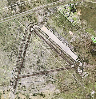
Garner Field is an airport in Uvalde County, Texas, three miles east of the city of Uvalde, which owns it. It is named for John Nance Garner, 32nd Vice President of the United States.

Cross City Air Force Station Former United States Air Force facility

Cross City Air Force Station is a former United States Air Force facility, located 1.6 miles (2.6 km) east of Cross City, Florida.

Stuttgart Army Air Field (Arkansas) Former airfield in Arkansas, United States

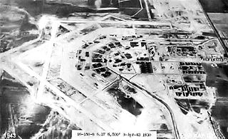
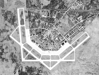
Stuttgart Army Airfield is a former World War II military airfield, located 7 miles north of Stuttgart, Arkansas. It operated as an advanced pilot training school for the United States Army Air Forces from 1942 until 1945.

Dole–Jura Airport Airport in Jura, France

Dole–Jura Airport, also known as Dole–Besançon–Dijon Airport, is an airport serving Dole, a commune in the Jura department in the Bourgogne-Franche-Comté region in eastern France. The airport is located 7 km (4 NM) southwest of Dole, and southeast of Tavaux. It was formerly known as Dole–Tavaux Airport. The airport is used for general aviation, and for a few commercial airline services.

Chartres – Champhol Aerodrome Airport

Chartres – Champhol Aerodrome is an airport serving Chartres and Champhol, in the Eure-et-Loir department in north-central France. The airport is located 2.5 km (1.3 NM) east-northeast of Chartres and it is southeast of Champhol. It supports general aviation with no commercial airline service scheduled.

Valenciennes-Denain Airport is a regional airport in France, located southwest of Valenciennes ; 115 miles (185 km) north-northeast of Paris

Echeverria Field Abandoned WWII-era USAAF airfield near Wickenburg, Arizona

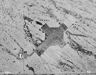
Echeverria Field is an abandoned airfield, located approximately 15 miles (24 km) west of Wickenburg, Arizona.

Thompson–Robbins Airport Airport

Thompson–Robbins Airport is 6 miles (9.7 km) northwest of the center of Helena-West Helena, in unincorporated Phillips County, Arkansas, United States. It is owned by the City of Helena-West Helena.

Taylor Field (Florida) Airport

Taylor Field, now an industrial park, was an airport and military airfield located near Ocala, Florida. It was closed in 1962 and replaced by Ocala International Airport-Jim Taylor Field.

Cuero Municipal Airport Airport in Cuero, Texas

Cuero Municipal Airport is a public airport located approximately 1 mile (1.6 km) east-southeast of Cuero, Texas. It provides general aviation service.

Bruce Field Airport

Bruce Field is a city-owned public-use general aviation airport located five nautical miles southwest of the central business district of Ballinger, a city in Runnels County, Texas, United States.

W. R. Byron Airport Airport

W. R. Byron Airport is a privately owned, private use airport in Riverside County, California, United States. It is located four nautical miles northwest of the central business district of Blythe, California, within the city limits.

Arledge Field Airport in near Stamford, Texas

Arledge Field is a public general aviation airport located approximately 4 miles (6.4 km) east of Stamford, Texas. Owned by the city of Stamford, it provides general aviation service. Approximately 80 aircraft use the airport on a weekly basis.

Courtland Army Airfield Former US Army airfield in Alabama

Courtland Army Airfield is a former United States Army facility located two nautical miles northeast of the central business district of Courtland, a town in Lawrence County, Alabama, United States.

Eagle Pass Army Airfield Airport

Eagle Pass Army Airfield is a former World War II military airfield complex. It is located 10.6 miles (17.1 km) north of Eagle Pass, Texas. It operated as a training base for the United States Army Air Forces from 1943 until 1945.

References

Notes

  1. 1 2 3 4 5 6 Freeman, Paul. "Anniston AAF/Talladega Airport". Abandoned and Little-Known Airfields, The Birmingham, Alabama Area. Retrieved 25 September 2012.
  2. 1 2 Abstract, History of Detachment 108th AACS Squadron August 1945 (retrieved unknown)
  3. Anniston Star newspaper – June 20, 1963
  4. "ATAP, Inc. – Supporting the Warfighter since 1962".

Bibliography

PD-icon.svg This article incorporates  public domain material from the Air Force Historical Research Agency website http://www.afhra.af.mil/ .

Further Reading