Anomalous propagation (sometimes shortened to anaprop or anoprop)[1] includes different forms of radio propagation due to an unusual distribution of temperature and humidity with height in the atmosphere.[2] While this includes propagation with larger losses than in a standard atmosphere, in practical applications it is most often meant to refer to cases when signal propagates beyond normal radio horizon.
Anomalous propagation can cause interference to VHF and UHF radio communications if distant stations are using the same frequency as local services. Over-the-air analog television broadcasting, for example, may be disrupted by distant stations on the same channel, or experience distortion of transmitted signals ghosting). Radar systems may produce inaccurate ranges or bearings to distant targets if the radar "beam" is bent by propagation effects. However, radio hobbyists take advantage of these effects in TV and FM DX.
Causes
Air temperature profile
Super refraction in radar operation
The first assumption of the prediction of propagation of a radio wave is that it is moving through air with temperature that declines at a standard rate with height in the troposphere. This has the effect of slightly bending (refracting) the path toward the Earth, and accounts for an effective range that is slightly greater than the geometric distance to the horizon. Any variation to this stratification of temperatures will modify the path followed by the wave.[2] Changes to the path can be separated into super and under refraction:[3]
Super refraction
"Super refraction" redirects here. For the music album, see Super Refraction.
It is very common to have temperature inversions forming near the ground, for instance air cooling at night while remaining warm aloft. This happens equally aloft when a warm and dry airmass overrides a cooler one, like in the subsidence aloft cause by a high pressure intensifying. The index of refraction of air increases in both cases and the EM wave bends toward the ground instead of continuing upward.
On surface-base inversion, the beam will eventually hit the ground and a part of it can be reflected back toward the emitter. In upper air inversion, the bending will be limited to the layer involved but the bending will extend the path of the beam, possibly beyond the usual transmission horizon.
When the inversion is very strong and shallow, the EM wave is trapped within the inversion layer. The beam will bounce many times inside the layer as within a waveguide. In surface-based ducting, the beam will hit the ground many times, causing return echoes at regular distances toward the emitter. In elevated ducts, the transmission can be extended to very large distances.
Under refraction
Under refraction in radar operation
On the other hand, if the air is unstable and cools faster than the standard atmosphere with height, the wave is higher than expected and can miss the intended receiver.
Finally, multipath propagation near the Earth's surface has multiple causes, including atmospheric ducting, ionospheric reflection and refraction, and reflection from water bodies and terrestrial objects such as mountains and buildings.
In radio
Anomalous propagation can be a limiting factor for the propagation of radiowaves, especially the super refraction. However, reflection on the ionosphere is a common use of this phenomenon to extend the range of the signal. Other multiple reflections or refractions are more complex to predict but can be still useful.
Radar
The position of the radar echoes depend heavily on the standard decrease of temperature hypothesis. However, the real atmosphere can vary greatly from the norm. Anomalous Propagation (AP) refers to false radar echoes usually observed when calm, stable atmospheric conditions, often associated with super refraction in a temperature inversion, direct the radar beam toward the ground. The processing program will then wrongly place the return echoes at the height and distance it would have been in normal conditions.[4]
This type of false return is relatively easy to spot on a time loop if it is due to night cooling or marine inversion as one sees very strong echoes developing over an area, spreading in size laterally, not moving but varying greatly in intensity with time. After sunrise, the inversion disappears gradually and the area diminishes correspondingly. Inversion of temperature exists too ahead of warm fronts, and around thunderstorms' cold pool. Since precipitation exists in those circumstances, the abnormal propagation echoes are then mixed with real rain and/or targets of interest, which make them more difficult to separate.
Anomalous Propagation is different from ground clutter, ocean reflections (sea clutter), biological returns from birds and insects, debris, chaff, sand storms, volcanic eruption plumes, and other non-precipitation meteorological phenomena. Ground and sea clutters are permanent reflection from fixed areas on the surface with stable reflective characteristics. Biological scatterer gives weak echoes over a large surface. These can vary in size with time but not much in intensity. Debris and chaff are transient and move in height with time. They are all indicating something actually there and either relevant to the radar operator and/or readily explicable and theoretically able to be reproduced. AP in the sense of radar is colloquially known as "garbish" and ground clutter as "rubbage".[citation needed]
Doppler radars and Pulse-Doppler radars are extracting the velocities of the targets. Since AP comes from stable targets, it is possible to subtract the reflectivity data having a null speed and clean the radar images. Ground, sea clutter and the energy spike from the sun setting can be distinguished the same way but not other artifacts.[4][5] This method is used in most modern radars, including air traffic control and weather radars.
1 2 W.L.Patterson, C.P.Hattan, G.E.Lindem, R.A.Paulus, H.V.Hitney, K.D.Anderson, A.E.Barrios. Technical Document 2648. Engineer's Refractive Effects Prediction System (EREPS) Version 3.0. May 1994. San Diego, CA
The ionosphere is the ionized part of the upper atmosphere of Earth, from about 48 km (30 mi) to 965 km (600 mi) above sea level, a region that includes the thermosphere and parts of the mesosphere and exosphere. The ionosphere is ionized by solar radiation. It plays an important role in atmospheric electricity and forms the inner edge of the magnetosphere. It has practical importance because, among other functions, it influences radio propagation to distant places on Earth. It also affects GPS signals that travel through this layer.
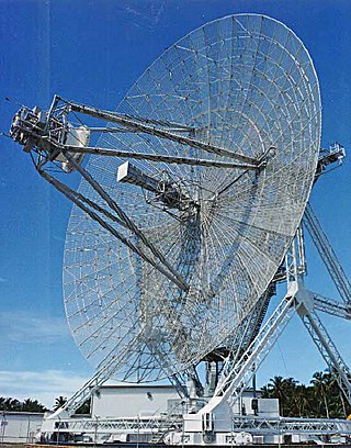
Radar is a radiolocation system that uses radio waves to determine the distance (ranging), angle (azimuth), and radial velocity of objects relative to the site. It is used to detect and track aircraft, ships, spacecraft, guided missiles, and motor vehicles, and map weather formations, and terrain. A radar system consists of a transmitter producing electromagnetic waves in the radio or microwaves domain, a transmitting antenna, a receiving antenna and a receiver and processor to determine properties of the objects. Radio waves from the transmitter reflect off the objects and return to the receiver, giving information about the objects' locations and speeds.
In telecommunications, an atmospheric duct is a horizontal layer in the lower atmosphere in which the vertical refractive index gradients are such that radio signals are guided or ducted, tend to follow the curvature of the Earth, and experience less attenuation in the ducts than they would if the ducts were not present. The duct acts as an atmospheric dielectric waveguide and limits the spread of the wavefront to only the horizontal dimension.
In meteorology, an inversion is a deviation from the normal change of an atmospheric property with altitude. It almost always refers to an inversion of the air temperature lapse rate, in which case it is called a temperature inversion. Normally, air temperature decreases with an increase in altitude, but during an inversion warmer air is held above cooler air.
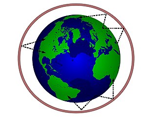
Line-of-sight propagation is a characteristic of electromagnetic radiation or acoustic wave propagation which means waves travel in a direct path from the source to the receiver. Electromagnetic transmission includes light emissions traveling in a straight line. The rays or waves may be diffracted, refracted, reflected, or absorbed by the atmosphere and obstructions with material and generally cannot travel over the horizon or behind obstacles.
The atmosphere of Earth is the layer of gases, known collectively as air, retained by Earth's gravity that surrounds the planet and forms its planetary atmosphere. The atmosphere of Earth creates pressure, absorbs most meteoroids and ultraviolet solar radiation, warms the surface through heat retention, allowing life and liquid water to exist on the Earth's surface, and reduces temperature extremes between day and night.
Wind shear, sometimes referred to as wind gradient, is a difference in wind speed and/or direction over a relatively short distance in the atmosphere. Atmospheric wind shear is normally described as either vertical or horizontal wind shear. Vertical wind shear is a change in wind speed or direction with a change in altitude. Horizontal wind shear is a change in wind speed with a change in lateral position for a given altitude.
TV DX and FM DX is the active search for distant radio or television stations received during unusual atmospheric conditions. The term DX is an old telegraphic term meaning "long distance."
Radio propagation is the behavior of radio waves as they travel, or are propagated, from one point to another in vacuum, or into various parts of the atmosphere. As a form of electromagnetic radiation, like light waves, radio waves are affected by the phenomena of reflection, refraction, diffraction, absorption, polarization, and scattering. Understanding the effects of varying conditions on radio propagation has many practical applications, from choosing frequencies for amateur radio communications, international shortwave broadcasters, to designing reliable mobile telephone systems, to radio navigation, to operation of radar systems.
In radio communication, skywave or skip refers to the propagation of radio waves reflected or refracted back toward Earth from the ionosphere, an electrically charged layer of the upper atmosphere. Since it is not limited by the curvature of the Earth, skywave propagation can be used to communicate beyond the horizon, at intercontinental distances. It is mostly used in the shortwave frequency bands.
Super high frequency (SHF) is the ITU designation for radio frequencies (RF) in the range between 3 and 30 gigahertz (GHz). This band of frequencies is also known as the centimetre band or centimetre wave as the wavelengths range from one to ten centimetres. These frequencies fall within the microwave band, so radio waves with these frequencies are called microwaves. The small wavelength of microwaves allows them to be directed in narrow beams by aperture antennas such as parabolic dishes and horn antennas, so they are used for point-to-point communication and data links and for radar. This frequency range is used for most radar transmitters, wireless LANs, satellite communication, microwave radio relay links, satellite phones, and numerous short range terrestrial data links. They are also used for heating in industrial microwave heating, medical diathermy, microwave hyperthermy to treat cancer, and to cook food in microwave ovens.
Weather radar, also called weather surveillance radar (WSR) and Doppler weather radar, is a type of radar used to locate precipitation, calculate its motion, and estimate its type. Modern weather radars are mostly pulse-Doppler radars, capable of detecting the motion of rain droplets in addition to the intensity of the precipitation. Both types of data can be analyzed to determine the structure of storms and their potential to cause severe weather.
A pulse-Doppler radar is a radar system that determines the range to a target using pulse-timing techniques, and uses the Doppler effect of the returned signal to determine the target object's velocity. It combines the features of pulse radars and continuous-wave radars, which were formerly separate due to the complexity of the electronics.
Over-the-horizon radar (OTH), sometimes called beyond the horizon radar (BTH), is a type of radar system with the ability to detect targets at very long ranges, typically hundreds to thousands of kilometres, beyond the radar horizon, which is the distance limit for ordinary radar. Several OTH radar systems were deployed starting in the 1950s and 1960s as part of early warning radar systems, but these have generally been replaced by airborne early warning systems. OTH radars have recently been making a comeback, as the need for accurate long-range tracking becomes less important with the ending of the Cold War, and less-expensive ground-based radars are once again being considered for roles such as maritime reconnaissance and drug enforcement.
Non-line-of-sight (NLOS) radio propagation occurs outside of the typical line-of-sight (LOS) between the transmitter and receiver, such as in ground reflections. Near-line-of-sight conditions refer to partial obstruction by a physical object present in the innermost Fresnel zone.
A wind profiler is a type of weather observing equipment that uses radar or sound waves (SODAR) to detect the wind speed and direction at various elevations above the ground. Readings are made at each kilometer above sea level, up to the extent of the troposphere. Above this level there is inadequate water vapor present to produce a radar "bounce." The data synthesized from wind direction and speed is very useful to meteorological forecasting and timely reporting for flight planning. A twelve-hour history of data is available through NOAA websites.
The Earth–ionosphere waveguide refers to the phenomenon in which certain radio waves can propagate in the space between the ground and the boundary of the ionosphere. Because the ionosphere contains charged particles, it can behave as a conductor. The earth operates as a ground plane, and the resulting cavity behaves as a large waveguide.
This is an index to articles about terms used in discussion of radio propagation.
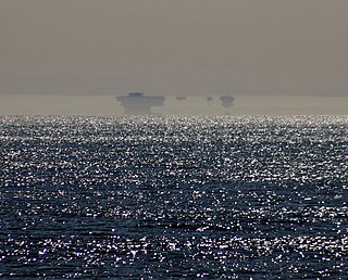
Tropospheric propagation describes electromagnetic propagation in relation to the troposphere. The service area from a VHF or UHF radio transmitter extends to just beyond the optical horizon, at which point signals start to rapidly reduce in strength. Viewers living in such a "deep fringe" reception area will notice that during certain conditions, weak signals normally masked by noise increase in signal strength to allow quality reception. Such conditions are related to the current state of the troposphere.
The radar horizon is a critical area of performance for aircraft detection systems that is defined by the distance at which the radar beam rises enough above the Earth's surface to make detection of a target at low level possible. It is associated with the low elevation region of performance, and its geometry depends on terrain, radar height, and signal processing. This is associated with the notions of radar shadow, the clutter zone, and the clear zone.
This page is based on this Wikipedia article Text is available under the CC BY-SA 4.0 license; additional terms may apply. Images, videos and audio are available under their respective licenses.