Hugo is a statutory town in and the county seat of Lincoln County, Colorado, United States. The town population was 787 at the 2020 census.

Moab is the largest city and county seat of Grand County in eastern Utah in the western United States, known for its dramatic scenery. The population was 5,366 at the 2020 census. Moab attracts many tourists annually, mostly visitors to the nearby Arches and Canyonlands National Parks. The town is a popular base for mountain bikers who ride the extensive network of trails including the Slickrock Trail, and for off-roaders who come for the annual Moab Jeep Safari.

Kanab is a city in and the county seat of Kane County, Utah, United States. It is located on Kanab Creek just north of the Arizona state line. This area was first settled in 1864, and the town was founded in 1870 when 10 Mormon families moved into the area. Named for a Paiute word meaning "place of the willows," Fort Kanab was built on the east bank of Kanab Creek in 1864 for offensive operations against the original inhabitants of the area and as a base for the exploration of the area. The population was 4,683 at the 2020 census.

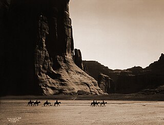
Canyon de Chelly National Monument was established on April 1, 1931, as a unit of the National Park Service. Located in northeastern Arizona, it is within the boundaries of the Navajo Nation and lies in the Four Corners region. Reflecting one of the longest continuously inhabited landscapes of North America, it preserves ruins of the indigenous tribes that lived in the area, from the Ancestral Puebloans to the Navajo. The monument covers 83,840 acres and encompasses the floors and rims of the three major canyons: de Chelly, del Muerto, and Monument. These canyons were cut by streams with headwaters in the Chuska Mountains just to the east of the monument. None of the land is federally owned. Canyon de Chelly is one of the most visited national monuments in the United States.

Navajo Bridge is the name of twin steel spandrel arch bridges that cross the Colorado River in the Grand Canyon National Park in northern Coconino County, Arizona, United States. The newer of the two spans carries vehicular traffic on U.S. Route 89A (US 89A) over Marble Canyon between Bitter Springs and Jacob Lake, allowing travel into a remote Arizona Strip region north of the Colorado River including the North Rim of Grand Canyon National Park.
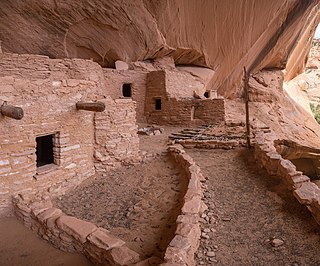
Navajo National Monument is a National Monument located within the northwest portion of the Navajo Nation territory in northern Arizona, which was established to preserve three well-preserved cliff dwellings of the Ancestral Puebloan people: Keet Seel, Betatakin, and Inscription House. The monument is high on the Shonto plateau, overlooking the Tsegi Canyon system, west of Kayenta, Arizona. It features a visitor center with a museum, three short self-guided trails, two small campgrounds, and a picnic area.
America's 11 Most Endangered Places or America's 11 Most Endangered Historic Places is a list of places in the United States that the National Trust for Historic Preservation considers the most endangered. It aims to inspire Americans to preserve examples of architectural and cultural heritage that could be "relegated to the dustbins of history" without intervention.

Fort Yuma was a fort in California located in Imperial County, across the Colorado River from Yuma, Arizona. It was on the Butterfield Overland Mail route from 1858 until 1861 and was abandoned May 16, 1883, and transferred to the Department of the Interior. The Fort Yuma Indian School and the Saint Thomas Yuma Indian Mission now occupy the site. It is one of the "associated sites" listed as Yuma Crossing and Associated Sites on the National Register of Historic Places in the Yuma Crossing National Heritage Area. In addition, it is registered as California Historical Landmark #806.
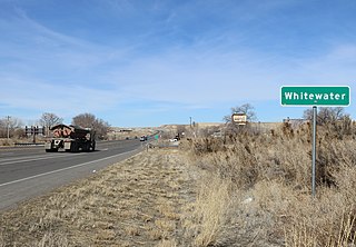
Whitewater is an unincorporated community with a U.S. Post Office in Mesa County, Colorado, United States, just south of Grand Junction. The Whitewater Post Office has the ZIP Code 81527. It is located on the banks of the Gunnison River near the confluences with Whitewater Creek and Kannah Creek to the south.

Danger Cave is a North American archaeological site located in the Bonneville Basin of western Utah around the Great Salt Lakes region, that features artifacts of the Desert Culture from c. 9000 BC until c. 500 AD. Through carbon-14 dating, it has been determined that there is very little evidence of human life in the Danger Cave area c. 11,000 BP [9000 BC], but there is much evidence of human life by 9000 BP [7000 BC].

This is an alphabetical list of articles related to the U.S. State of Colorado.

Yuma Quartermaster Depot State Historic Park, formerly Yuma Crossing State Historic Park, and now one of the Yuma Crossing and Associated Sites on the National Register of Historic Places in the Yuma Crossing National Heritage Area. It is an Arizona state park in the city of Yuma, Arizona, US.

The Trail of the Ancients is a collection of National Scenic Byways located in the U.S. Four Corners states of Utah, Colorado, New Mexico, and Arizona. These byways comprise:
The Trinchera Cave Archeological District (5LA9555) is an archaeological site in Las Animas County, Colorado with artifacts primarily dating from 1000 BC to AD 1749, although there were some Archaic period artifacts found. The site was added to the National Register of Historic Places in 2001 and is located on State Trust Lands.

The Cameron Suspension Bridge crosses the Little Colorado River at Cameron, Arizona, United States.

The Historic Pinal Cemetery, first known simply as "Pinal Cemetery", is a cemetery located on a hill in what once within the jurisdiction of the now ghost town of Pinal City, Arizona. The Pioneers' Cemetery Association (PCA) defines a "historic cemetery" as one which has been in existence for more than fifty years. In 2009, the Tonto National Forest made it its goal to develop and manage the cemetery as an interpretive site while preserving its historic context and integrity as an archaeological resource. Among those who are buried in the cemetery is Celia Ann “Mattie” Blaylock Earp who was Wyatt Earp's common law wife. The role of Mattie Earp was played by actress Dana Wheeler-Nicholson in the 1993 American Western film Tombstone.
