
The Ring of Fire is a major area in the basin of the Pacific Ocean where many earthquakes and volcanic eruptions occur. In a large 40,000 km (25,000 mi) horseshoe shape, it is associated with a nearly continuous series of oceanic trenches, volcanic arcs, and volcanic belts and plate movements. It has 452 volcanoes.
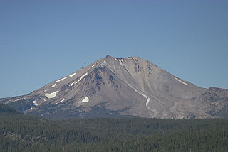
Lassen Peak, commonly referred to as Mount Lassen, is the southernmost active volcano in the Cascade Range of the Western United States. Located in the Shasta Cascade region of Northern California, it is part of the Cascade Volcanic Arc, which stretches from southwestern British Columbia to northern California. Lassen Peak reaches an elevation of 10,457 feet (3,187 m), standing above the northern Sacramento Valley. It supports many flora and fauna among its diverse habitats, which are subject to frequent snowfall and reach high elevations.

Mount Spurr is a stratovolcano in the Aleutian Arc of Alaska, named after United States Geological Survey geologist and explorer Josiah Edward Spurr, who led an expedition to the area in 1898. The Alaska Volcano Observatory (AVO) currently rates Mount Spurr as Level of Concern Color Code Green. The mountain is known aboriginally by the Dena'ina Athabascan name K'idazq'eni, literally 'that which is burning inside'.

Mount Shishaldin is a moderately active volcano on Unimak Island in the Aleutian Islands chain of Alaska. It is the highest mountain peak of the Aleutian Islands. The most symmetrical cone-shaped glacier-clad large mountain on Earth, the volcano's topographic contour lines are nearly perfect circles above 6,500 feet (2,000 m). The lower north and south slopes are somewhat steeper than the lower eastern and western slopes. The volcano is the westernmost of three large stratovolcanoes along an east–west line in the eastern half of Unimak Island.
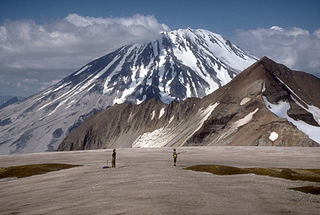
Mount Griggs, formerly known as Knife Peak Volcano, is a stratovolcano, which lies 10 km behind the volcanic arc defined by other Katmai group volcanoes. Although no historic eruptions have been reported from Mount Griggs, vigorously active fumaroles persist in a summit crater and along the upper southwest flank. The fumaroles on the southwest flank are the hottest, and some of the flank fumaroles can roar so loudly that they can be heard from the valley floor. The slopes of Mount Griggs are heavily mantled by fallout from the 1912 eruption of Novarupta volcano. The summit consists of three concentric craters, the lowest and largest of which contains a recent summit cone topped by two craters. The volume of the volcanic edifice is estimated at about 25 cubic kilometers (6.0 cu mi). Isotopic analysis indicates that the source of Griggs' magma is distinct from the other Katmai volcanoes.

Mount Emmons is a post-caldera stratovolcano within the Emmons Lake caldera on the Alaska Peninsula within the Lake and Peninsula Borough, Alaska, United States.

The Makushin Volcano is an ice-covered stratovolcano located on Unalaska Island in the Aleutian Islands of the U.S. state of Alaska. With an elevation of 2,036 meters (6,680 ft), its summit is the highest point on the island. Makushin is one of the most active among the 52 historically active volcanoes of Alaska. It has erupted at least two dozen times over the past several thousand years, with the last eruption occurring in 1995.

Mount Okmok is the highest point on the rim of Okmok Caldera on the northeastern part of Umnak Island in the eastern Aleutian Islands of Alaska. This 5.8 mile (9.3 km) wide circular caldera truncates the top of a large shield volcano. A crater lake once filled much of the caldera, but the lake ultimately drained through a notch eroded in the northeast rim. The prehistoric lake attained a maximum depth of about 150 m (500 ft) and the upper surface reached an elevation of about 475 m (1560 ft), at which point it overtopped the low point of the caldera rim. Small, shallow remnants of the lake remained north of Cone D at an altitude of about 1075 feet: a small shallow lake located between the caldera rim and Cone D; a smaller lake farther north near the caldera's gate. After the 2008 eruption, the hydrogeology of the caldera was greatly changed with five separate sizable lakes now emplaced. In addition to the caldera lakes, Cone A, Cone E, Cone G and the new 2008 vent on Cone D contain small crater lakes. The last major eruptions of Okmok—with a VEI strength of 6—occurred 8,300 and 2,400 years Before Present.

Mount Vsevidof is a stratovolcano in the U.S. state of Alaska. Its summit is the highest point on Umnak Island, one of the eastern Aleutian Islands. Its symmetrical cone rises abruptly from its surroundings. The base of the volcano is around 10km wide, steepening from about 15 degrees at 300m altitude to around 30 degrees near the summit. Some glacial tongues have cut through narrow canyons up to 120m deep, due to ice filling the crater and extending down the north and east flanks of the cone. Vsevidof's most recent eruption was caused by an earthquake on March 9, 1957. The mountain erupted on March 11, 1957, and the eruption ended the next day.

Mount Cleveland is a nearly symmetrical stratovolcano on the western end of Chuginadak Island, which is part of the Islands of Four Mountains just west of Umnak Island in the Fox Islands of the Aleutian Islands of Alaska. Mt. Cleveland is 5,675 ft (1,730 m) high, and one of the most active of the 75 or more volcanoes in the larger Aleutian Arc. Aleutian natives named the island after their fire goddess, Chuginadak, who they believed inhabited the volcano. In 1894 a team from the U.S. Coast and Geodetic Survey visited the island and gave Mount Cleveland its current name, after then-president Grover Cleveland.

Frosty Peak Volcano, also known as Mt. Frosty, Frosty Volcano, or Cold Bay Volcano, is a 6,299 ft (1,920 m) stratovolcano at the southwest end of the Alaska Peninsula in the U.S. state of Alaska.
The undissected stratovolcano of Amukta volcano makes up most of nearly circular, 7.7-km-wide Amukta Island. It is the westernmost of the Islands of Four Mountains chain. The cone, about 5.8 km in basal diameter and topped by a 0.4 km wide summit crater, appears on synthetic-aperture radar imagery to be built upon a 300+ meter high, east-west trending arcuate ridge. Extensions of that ridge on the southwest and east sides of the island indicate an older caldera approximately 6 km in diameter and open to the sea on the south side. No hot springs or fumaroles have been reported from Amukta. Sekora reports the presence of a cinder cone near the northeastern shore of the island.
Mount Iliamna is a glacier-covered stratovolcano in the largely volcanic Aleutian Range in southwest Alaska. Located in the Chigmit Mountain subrange in Lake Clark National Park and Preserve, the 10,016-foot (3,053 m) volcano lies approximately 134 miles (215 km) southwest of Anchorage on the west side of lower Cook Inlet. It is the 25th most prominent peak in the United States.

Semisopochnoi Island or Unyak Island is part of the Rat Islands group in the western Aleutian Islands of Alaska. The island is uninhabited and provides an important nesting area for maritime birds. The island is of volcanic origin, containing several volcanoes including Mount Cerberus. It has a land area of 85.558 square miles, measuring 11 miles in length and 12 miles in width.

The Gareloi Volcano is a stratovolcano in the Aleutian Islands of Alaska, United States, about 1,259 miles (2,026 km) from Anchorage. Gareloi is located on Gareloi Island, and comprises most of its land mass. The island also has two small glaciers which protrude to the northwest and southeast.

Amak Volcano is a basaltic andesite stratovolcano in the Aleutian Islands of Alaska, USA, 618 miles (995 km) from Anchorage. It is located on the eponymous island, 31 miles (50 km) from Frosty Volcano and near the edge of the Alaskan Peninsula's western flank. Only boats are allowed to access the island with a certain permit.
Segula Volcano lies 1,228 miles (1,976 km) westward of Anchorage on the Segula Island in the Aleutian Islands of Alaska. An inactive stratovolcano, it has not produced any historical eruptions, while barely eroded deposits on the flanks suggest that activity took place at the volcano as late as a couple of hundred years ago.

The volcanic history of the Northern Cordilleran Volcanic Province presents a record of volcanic activity in northwestern British Columbia, central Yukon and the U.S. state of easternmost Alaska. The volcanic activity lies in the northern part of the Western Cordillera of the Pacific Northwest region of North America. Extensional cracking of the North American Plate in this part of North America has existed for millions of years. Continuation of this continental rifting has fed scores of volcanoes throughout the Northern Cordilleran Volcanic Province over at least the past 20 million years and occasionally continued into geologically recent times.
