Aptos was traditionally inhabited by the Awaswas tribe of Ohlone people. The name is one of only three native words that have survived (in Hispanicized form) as place names in Santa Cruz County (the others are Soquel and Zayante).
The first European land exploration of Alta California, the Spanish Portolá expedition, passed through the area on its way north, camping at one of the creeks on October 16, 1769. The expedition diaries don't provide enough information to be sure which creek it was, but the direction of travel was northwest, parallel to the coast. Franciscan missionary Juan Crespi, traveling with the expedition, noted in his diary that, "We stopped on the bank of a small stream, which has about four varas of deep running water. It has on its banks a good growth of cottonwoods and alders; on account of the depth at which it runs it may be that it cannot be utilized to water some plains through which it runs."[5] Crespi diary translator Herbert Bolton speculated that the location was Soquel Creek, but it could have been Aptos Creek.
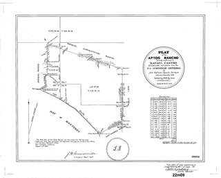
In 1833 the government of Mexico granted Rafael Castro the 6,656-acre (26.94km2)Rancho Aptos. Initially Castro raised cattle for their hides, but after California became a state in 1850, Castro leased his land to Americans who built a wharf, general store, and lumber mill. The original town was located where Aptos Village Square is now. In 1853 a leather tannery was built, and the main building is a bed & breakfast inn [citation needed].
In 1875, Frederick A. Hihn and Claus Spreckels partnered to build the Santa Cruz Railroad, and routed it through Aptos where they both had development interests - Hihn with the Loma Prieta Lumber Company, and Spreckels with his Aptos Hotel resort. The railroad tracks ran directly adjacent to the Santa Cruz Watsonville road, whose route was originally established by the 1769 Spanish exploratory expedition led by Gaspar de Portolá.
Bayview Hotel in Aptos
In 1878 Augustia Castro, daughter of Rafael Castro, and her husband José Arano built the Victorian, Bayview Hotel in Aptos village. The hotel is a Santa Cruz County landmark. It is Santa Cruz county's oldest operating hotel. It has been a State Historic Monument since 1974 and listed on the National Register of Historic Places since 1993.[6][7] Since being originally built, the hotel was moved to its current location.[8][9]
In the mid to late 1800s, a series of major epidemics hit the area. A particularly bad one occurred in the early winter of 1868. Cases of smallpox were reported among the poor of San Juan Bautista. Efforts were made to localize the rapidly spreading disease, such as, barricading the roads leading in and out of San Juan Bautista. These efforts failed however, and when cases appeared in Watsonville, Santa Cruz citizens attempted to again quarantine the disease by destroying the Aptos Bridge. These efforts again failed and only created a rift between the two cities. The death toll of the smallpox epidemic lead to the local press publishing of the latest remedies available for home use as well as methods to prevent the spread of smallpox and inoculations.[10][11]
By 1872, Claus Spreckels, a sugar millionaire, began buying the land from Castro. He built a hotel near the beach and a summer mansion and ranch with a racetrack for his horses. A large area was fenced and stocked with deer for hunting, and became known as "the Deer Park," home of today's Deer Park Center.
From 1880 to 1920 redwood timber harvesting became the major industry, and Aptos became a boom town. The Loma Prieta Lumber Company logged all of what is now The Forest of Nisene Marks State Park. The Valencia Mill logged everything to the east. Within 40 years the hills were bare, and apples became the next industry. The Hihn Apple Barn is a historic building from that era; in 2016-2017, the building had been relocated nearby to be used as a grocery store and make way for a shopping complex.
On March 16–20, 1905, the Leonard Ranch near La Selva was the site of experiments with a new tandem-wing glider designed and built by John J. Montgomery. Hoisted aloft by hot-air balloon to considerable heights, over a series of test flights pilot Daniel J. Maloney was able to demonstrate the control and flight of the Montgomery glider design. These flights, with starting altitudes over 3,000 feet above the ground, were the first high-altitude flights in the world.[12] A marker was placed at this location in 2005 honoring the centennial of these accomplishments.[13]
After Spreckels' death, Seacliff Park and Rio Del Mar Country Club (today's Seacliff State Beach) were developed in the late 1920s. Rio Del Mar Country Club included a clubhouse, a grand hotel on the bluffs, a beach club, a polo field, and a golf course. The estuary was filled in (now Rio Beach Flats) and the SS Palo Alto cement ship was moored and converted into an amusement pier with restaurants, swimming pool, and a dance pavilion. Both Rio Del Mar and Seacliff were popular during Prohibition as drinking and gambling were discreetly available. These amusements were interrupted by the Great Depression and World War II.
In the early 1960s Aptos began a period of rapid development, including Cabrillo College, Rancho Del Mar Shopping Center, the Seascape Resort development, and many residential developments.
In 2020s, Microsoft named a new Windows font after this community.[14][15]
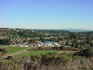
For statistical purposes, the United States Census Bureau has defined Aptos as a census-designated place (CDP). The census definition of the area is limited in contrast to the local understanding of the area with the same name. The population of the CDP was 6,220 at the 2010 census.[16] The CDP has a total area of 6.4 square miles (17km2), all land. The southwestern geographical boundary is Monterey Bay, while the northeast boundary is the Santa Cruz Mountains.
Aptos is bisected northwest-to-southeast by the State Route 1 freeway and includes the ZIP codes 95001 and 95003.
The census reported that 98.7% of the population lived in households and 1.3% lived in non-institutionalized group quarters.
There were 2,549 households, out of which 686 (26.9%) had children under the age of 18 living, 1,353 (53.1%) were married couples living together, 192 (7.5%) had a female householder with no husband present, 95 (3.7%) had a male householder with no wife present. There were 142 (5.6%) unmarried. 665 households (26.1%) were made up of individuals, and 268 (10.5%) had someone living alone who was 65 years of age or older. The average household size was 2.41. There were 1,640 families (64.3% of all households); the average family size was 2.86.
The population was spread out, with 1,150 people (18.5%) under the age of 18, 436 people (7.0%) aged 18 to 24, 1,342 people (21.6%) aged 25 to 44, 2,189 people (35.2%) aged 45 to 64, and 1,103 people (17.7%) who were 65 years of age or older. The median age was 46.9 years. For every 100 females, there were 97.8 males. For every 100 females age 18 and over, there were 96.8 males.[20]
There were 2,711 housing units at an average density of 426.7 per square mile (164.7/km2), of which 75.6% were owner-occupied and 24.4% were occupied by renters. The homeowner vacancy rate was 1.5%; the rental vacancy rate was 0.8%. 75.2% of the population lived in owner-occupied housing units and 23.5% lived in rental housing units.[20]
2000
As of the census[21] of 2000, there were 9,396 people, 4,055 households, and 2,428 families residing in the CDP. The population density was 1,339.6 inhabitants per square mile (517.2/km2). There were 4,486 housing units at an average density of 639.6 per square mile (247.0/km2). The racial makeup of the CDP was 90.38% White, 0.56% African American, 0.65% Native American, 2.39% Asian, 0.11% Pacific Islander, 2.49% from other races, and 3.42% from two or more races. Hispanic or Latino of any race were 6.97% of the population.
There were 4,055 households, out of which 25.8% had children under the age of 18 living with them, 48.1% were married couples living together, 8.1% had a female householder with no husband present, and 40.1% were non-families. 27.5% of all households were made up of individuals, and 8.2% had someone living alone who was 65 years of age or older. The average household size was 2.29 and the average family size was 2.78.
In the CDP, the population was spread out, with 19.3% under the age of 18, 6.5% from 18 to 24, 30.9% from 25 to 44, 29.4% from 45 to 64, and 14.0% who were 65 years of age or older. The median age was 41 years. For every 100 females, there were 94.7 males. For every 100 females age 18 and over, there were 92.0 males.[22]
The median income for a household in the CDP was $61,843, and the median income for a family was $73,515. Males had a median income of $51,848 versus $40,050 for females. The per capita income for the CDP was $33,210. About 2.5% of families and 7.1% of the population were below the poverty line, including 3.4% of those under age 18 and 6.2% of those age 65 or over.[20]
Aptos has three public elementary schools: Valencia Elementary, Rio Del Mar Elementary, and Mar Vista Elementary.[31][citation needed][32] It also has one junior high school, Aptos Junior High School,[33] and one high school, Aptos High School.[34] Private schools include Santa Cruz Montessori School,[35] Orchard School,[36] and Twin Lakes Christian School.[37] Aptos Academy, a pre-school through eighth grade private school, closed in 2013.[38]
Sports
The Aptos Little League baseball team made it to the Little League World Series in 2002, and was the subject of a documentary film on PBS, Small Ball: A Little League Story.[39]
Harry Hooper, Major League Baseball player and member of the Hall of Fame, lived in Capitola, California and is buried in Aptos. Harry Hooper was one of two players traded by the Boston Red Sox, along with Babe Ruth, that created the Curse of the Bambino.
Edmund Kemper, also known as the Co-ed Butcher or the Co-ed Killer, an American serial killer, necrophile, and cannibal
Santa Cruz is the largest city and the county seat of Santa Cruz County, in Northern California. As of the 2020 census, the city population was 62,956. Situated on the northern edge of Monterey Bay, Santa Cruz is a popular tourist destination, owing to its beaches, surf culture, and historic landmarks.
Santa Cruz County, officially the County of Santa Cruz, is a county on the Pacific coast of the U.S. state of California. As of the 2020 census, the population was 270,861. The county seat is Santa Cruz. Santa Cruz County comprises the Santa Cruz–Watsonville, CA Metropolitan Statistical Area, which is also included in the San Jose–San Francisco–Oakland, CA Combined Statistical Area. The county is on the California Central Coast, south of the San Francisco Bay Area region. The county forms the northern coast of the Monterey Bay, with Monterey County forming the southern coast.
Montara is a census-designated place (CDP) in San Mateo County, California, United States. The population was 2,833 at the 2020 census. Nearby communities include Moss Beach and Princeton-by-the-Sea.
Lexington Hills is a census-designated place and an unincorporated area in Santa Clara County, California, United States. The population was 2,492 at the 2020 census. The area is located in the Santa Cruz Mountains, about five miles south of Los Gatos and about 14 miles (23 km) north of Santa Cruz. Lexington Hills is the name assigned by the United States Census Bureau to the area, which actually comprises several small communities, including Redwood Estates, Holy City, Chemeketa Park, and Aldercroft Heights.
Aptos Hills-Larkin Valley is an unincorporated community in Santa Cruz County, California, United States. It is identified as one of several small communities with a combined population of 24,402 forming the unincorporated town of Aptos by the local Chamber of Commerce along with:
Felton is a census-designated place (CDP) in Santa Cruz County, California, United States. The population was 4,489 as of 2020 census and according to the United States Census Bureau, the CDP has a total area of 4.6 square miles (12 km2), all of it land.
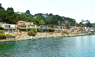
Rio del Mar is an unincorporated village in Santa Cruz County, California. Rio del Mar is one of several small villages that form the unincorporated community of Aptos, California. Its population was 9,128 as of the 2020 United States census. For statistical purposes, the United States Census Bureau has defined Rio del Mar as a census-designated place (CDP).
Soquel is an unincorporated town and census-designated place (CDP) in Santa Cruz County, California, located on the northern coast of Monterey Bay. The population was 9,980 at the 2020 census.
Adolph Claus J. Spreckels was a major industrialist in Hawai'i during the kingdom, republican, and territorial periods of the islands' history. He also involved himself in several California enterprises, most notably the company that bears his name, Spreckels Sugar Company.
Loma Mar is a census-designated place (CDP) in San Mateo County, California. It is near San Mateo County Memorial Park on Pescadero Creek Road and is in area code 650. Loma Mar is between the towns of Pescadero and La Honda, situated in the Santa Cruz Mountains in the western part of the San Francisco Peninsula. The United States Postal Service has assigned it ZIP Code 94021. As of the census of 2020, there were 134 residents in the CDP. Loma Mar is home to the YMCA's Camp Loma Mar, Redwood Glen Camp and Conference Center as well as a small number of businesses and services including the Loma Mar Store, a post office, and a fire station run by volunteers.
Seacliff State Beach is a state beach park on Monterey Bay, in the town of Aptos, Santa Cruz County, California. It is located off Highway 1 on State Park Drive, about 5 miles (8 km) south of Santa Cruz. The beach is most known for the concrete ship SS Palo Alto lying in the water. North of Seacliff State Beach is New Brighton State Beach.
Mount Hermon is an unincorporated community and census-designated place (CDP) in Santa Cruz County, California.
The Forest of Nisene Marks State Park is a state park of California, United States, protecting a secondary forest in the watershed of Aptos Creek and Soquel Creek within the Santa Cruz Mountains. It is located outside Aptos, California, and contains over 40 miles (64 km) of hiking trails and fire roads through 10,223 acres (4,137 ha) of variable terrain.
La Selva Beach is a census-designated place (CDP) in Santa Cruz County, California. La Selva Beach sits at an elevation of 151 feet (46 m). The 2020 United States census reported La Selva Beach's population was 2,531.
Pajaro Valley Unified School District is a school district based in Watsonville, California, USA. The Superintendent is Michelle Rodriguez. The District is overseen by a seven members of the board of trustees that meets an average of twice a month.
Seacliff is an unincorporated community in Santa Cruz County, California, United States that includes Seacliff State Beach. It is identified as one of several small communities with a combined population of 24,402 forming the unincorporated town of Aptos by the local Chamber of Commerce along with:
Rancho Aptos was a 6,686-acre (27.06 km2) Mexican land grant in present day Santa Cruz County, California given in 1833 by Governor José Figueroa to Rafael Castro. The grant on the Monterey Bay was immediately downcoast of his sister, Martina Castro's Rancho Soquel, and upcoast of his father, José Joaquín Castro's Rancho San Andrés. Rancho Aptos stretched from the area just to the west of Aptos Creek to parts of Nisene Marks and Day Valley in the north, and Rio del Mar to the east, including present day Aptos.
Pleasure Point is a census-designated place (CDP) in Santa Cruz County, California. Pleasure Point sits at an elevation of 33 feet (10 m). The 2020 United States census reported Pleasure Point's population was 5,821. Prior to the 2010 census, this CDP was called Opal Cliffs.
The Santa Cruz Railroad was a narrow gauge railroad that ran 21 miles from Santa Cruz to Pajaro, California. It started operation in 1874, running from the east bank of the San Lorenzo River to Soquel, California. With completion of a bridge over the San Lorenzo, it began operation over its full length in 1876 and was sold in foreclosure in 1881.
Aptos Creek is a southward flowing 9.5 miles (15.3 km) creek that begins on Santa Rosalia Mountain on the southwestern slope of the Santa Cruz Mountains in Santa Cruz County, California and enters Monterey Bay, at Seacliff State Beach in Aptos, California.
↑ Reader, Phil. "Voices of the Heart: Introduction". Santa Cruz County History - Disasters & Calamities. Santa Cruz Public Libraries. Archived from the original on May 18, 2015. Retrieved July 14, 2015.
↑ Harwood C.S., Fogel G.B. Quest for Flight: John J. Montgomery and the Dawn of Aviation in the West University of Oklahoma Press, 2012.
↑ "Cabrillo College". June 6, 2017. Archived from the original on June 6, 2017. Retrieved June 8, 2017.{{cite web}}: CS1 maint: bot: original URL status unknown (link)
↑ "Aptos Junior High School". October 19, 2016. Archived from the original on October 19, 2016. Retrieved June 8, 2017.{{cite web}}: CS1 maint: bot: original URL status unknown (link)
↑ "Santa Cruz Montessori". November 4, 2016. Archived from the original on November 4, 2016. Retrieved July 19, 2017.{{cite web}}: CS1 maint: bot: original URL status unknown (link)
↑ "Orchard School". November 14, 2016. Archived from the original on November 14, 2016. Retrieved June 8, 2017.{{cite web}}: CS1 maint: bot: original URL status unknown (link)
This page is based on this Wikipedia article Text is available under the CC BY-SA 4.0 license; additional terms may apply. Images, videos and audio are available under their respective licenses.