The age of the Hawthorne Group is not very clear. Much of the formation has been reworked, and there are few fossils that are diagnostic for a particular age. Some fossil evidence and correlations with neighboring formations indicate that the age of the Arcadian Formation ranges from the earliest Miocene to late Early Miocene (mid-Burdigalian faunal stage). More abundant planktonic, mollusc, and vertebrate fossils in the overlying Peace River Formation indicate that it began in the early Middle Miocene (early Langhian faunal stage.[3]
Extent
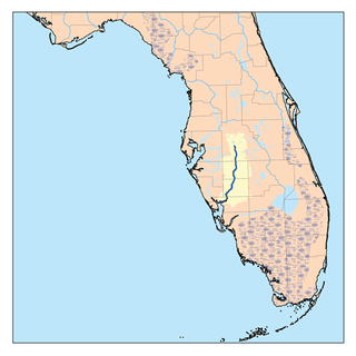
Extent of surface exposure of the Arcadia Formation.
The Arcadia Formation extends from at least Pasco and Polk counties in central Florida to Miami-Dade and Monroe counties at the southern end of the Florida peninsula, and possibly to the upper Florida Keys. It is thin or absent along the east coast of the Florida peninsula north of Indian River County. It is buried beneath later formations over most of its extent, with the exception of surface exposures in the area around Tampa Bay (in Hillsborough, Manatee, and Pasco counties). The top of the formation slopes downward from north to south, from more than 100 feet (30m) above mean sea level (MSL) in Polk County to 440 feet (130m) below MSL in Monroe County, and perhaps to more than 750 feet (230m) below MSL in Miami-Dade and Palm Beach counties. Although there is some variability in the slope of the top of the formation at the northern end, the general slope from north to south is about 5 feet per mile (95cm/km). The thickness of the formation also generally increases from north to south, to 593 feet (181m) in Charlotte County, and more than 650 feet (200m) in southern Miami-Dade County.[4]
Parts of the Arcadia Formation are designated the Nocatee and Tampa Members.[5] The Arcadia Formation has two distinct levels. The basal unit includes the Nocatee and Tampa Members and other unnamed Arcadia members, and an upper unit they call " Type Arcadia".[6]
Composition
The Arcadia Formation is composed of limestones and dolomites which are yellowish gray to light olive gray to light brown in color. The texture is micro to finely crystalline with varying sandy, clayey limestones and dolomites containing phosphate. The clays are yellowish gray to light olive gray in color. They are moderately hard as well as sandy, silty, phosphatic and dolomitic. Silicified carbonates and opalizedclaystone have also been found.[7]
Origin
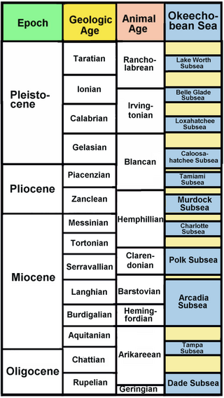
The Arcadia Formation developed when sea levels rose to flood much of the Florida Platform late in the Oligocene epoch. While part of central Florida remained above sea level as Orange Island, southern Florida was covered by the Okeechobean Sea, which extended over the Everglades basin, and was bound on the south by oyster banks, the Collier Bank curving up on the western side, and the Dade Bank curving up on the eastern side. What is now the central Gulf Coast of the Florida peninsula was covered by the Tampa Subsea, a large lagoon system separated from the open Gulf of Mexico by the Tampa Reef Tract and Tampa Archipelago. During the Aquitanian faunal stage (early in the Miocene), extensive upwelling around the Florida Platform carried plankton into the Okeechobean Sea and Tampa Subsea, depositing phosphorus-rich carbonate layers in the basins. The deposits in the Okeechobean Sea became the Nocatee Member of the Arcadia Formation, and the deposits in the Tampa Subsea became the Tampa Member.[8]
Nocatee Member
The Nocatee Member is the only part of the Arcadia Formation that is primarily siliciclastic. The member has a limited extent compared to the Arcadia Formation, occurring throughout Charlotte, DeSoto, and Hardee counties, in southwestern Polk County, in westernmost Highlands and Glades counties, in easternmost Manatee and Sarasota counties, and in northernmost Lee County.[9]
Tampa Member
The Tampa Member consists predominantly of limestone with subordinate dolomite, sand and clay very similar to that of the subsurface limestone part of the Arcadia Formation. There is considerably less phosphate. The color is white to yellowish gray. It is fossil bearing and variably sandy and clayey mudstone, wackestone, and packstone with little to no phosphate grains. Sand and clay beds are like those in the undifferentiated sediments of the Arcadia Formation.[10]
Invertebrate fossils from the Tampa Member were first collected in 1842 by Timothy Abbott Conrad. The fossil beds of the Tampa Member have since been studied by William Healey Dall, Gilbert Dennison Harris, and Angelo Heilprin, as well as others. The Fauna represented by the fossils is primarily marine, but including some land snails. The marine fauna is dominated by molluscs, but includes corals, barnacles, and foraminifera. Over 300 species of molluscs have been reported from the Tampa Member beds. The fossils suggest a late Oligocene to early Miocene age for the Tampa Member, but are not entirely diagnostic of age.[11]
In 1892 Dall divided the Tampa fossil bearing beds into two divisions, the "Orthaulax bed" (later called the "Orthaulax pugnax zone"), and the "Tampa Limestone". The two divisions were later united as the "Tampa Formation".[12] In 1945, C. W. Cooke classified the early Miocene strata throughout Florida as the "Tampa Limestone". In 1964, H. S. Puri and R. O. Vernon classified the Early Miocene strata in Florida as the "Tampa Stage", consisting of the Chattahoochee and St. Marks formations.[13] Scott demoted the "Tampa Formation" to "Tampa Member" and combined it with other previously unnamed Hawthorn Group strata in the "Arcadia Formation" in 1988.[14]
The Tampa Member is located in DeSoto, Hardee, Hillsborough, Manatee, Pinellas, and Sarasota counties, and the northern portion of Charlotte County. It consists of carbonate sediments deposited in the Early Miocene Hillsborough Lagoon System and the Tampa Reef Track and Tampa Archipelago, which bordered the lagoon system. The top of the Tampa Member is 23 m above mean sea level in northeastern Hillsborough County, dipping to more than 100 m below mean sea level in Manatee County and 98.5 m below mean sea level in Sarasota County. It has an average thickness of 30.5 m, reach 82 m thick in Sarasota County.[15] The Tampa Member lies above the Nocatee Member in some areas. It overlies undifferentiated Arcadia sediments in other areas, and is overlain by other undifferentiated Arcadia deposits.[16] Erosion has removed the Tampa Member north of Hillsborough County leaving only a few isolated remnants. Beds of Tampa sediments interleave with bed of undifferentiated Arcadia sediments throughout the lower part of the Arcadia Formation. Areas were the Tampa beds are thick and predominate are designated the Tampa Member, but thin, isolated Tampa beds are found elsewhere in the lower Arcadia Formation.[17]
Aquifers
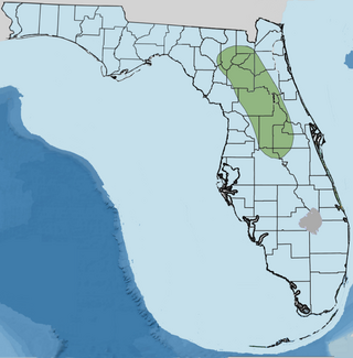
Two aquifers include parts of the Arcadia Formation. The Floridan Aquifer extends throughout Florida and most of the coastal plain in Georgia, as well as small adjacent areas in Alabama and South Carolina. The Florida Aquifer in general lies below the Arcadia Formation, with only the lower part of the Tampa Member included in the aquifer. The Florida Aquifer is the main source of fresh water for many cities and smaller communities throughout Florida. In 1985, more than 2.5billion US gallons (9.5Gl) per day were pumped from the aquifer.[18]
The Intermediate Aquifer System lies under southwestern Florida, from southern Hillsborough and southwestern Polk counties to Collier County. The aquifer includes the upper part of the Tampa Member, undifferentiated Arcadia Formation strata above the Tampa Member, the Peace River Formation, and the lower part of the Tamiami Formation, which lies above the Peace River Formation. As does the Arcadia Formation, the aquifer slopes and becomes thicker from north and northeast to south and southwest. The aquifer is the main source of fresh water for Sarasota, Charlotte and Lee counties.[19]
Paleofauna
The Arcadia Formation proper contains molds and casts in dolomite containing mollusks. The Tampa Member contains mollusks and corals in molds and casts with silicified pseudomorphs and shell material.
Related Research Articles
Manatee County is a county in the U.S. state of Florida. As of the 2020 US Census, the population was 399,710. Manatee County is part of the North Port-Bradenton-Sarasota, Florida Metropolitan Statistical Area. Its county seat and largest city is Bradenton. The county was created in 1855 and named for the Florida manatee, Florida's official marine mammal. Features of Manatee County include access to the southern part of the Tampa Bay estuary, the Sunshine Skyway Bridge, and the Manatee River.
The Floridan aquifer system, composed of the Upper and Lower Floridan aquifers, is a sequence of Paleogene carbonate rock which spans an area of about 100,000 square miles (260,000 km2) in the southeastern United States. It underlies the entire state of Florida and parts of Alabama, Georgia, Mississippi, and South Carolina.
The Bone Valley is a region of central Florida, encompassing portions of present-day Hardee, Hillsborough, Manatee, and Polk counties, in which phosphate is mined for use in the production of agricultural fertilizer. Florida currently contains the largest known deposits of phosphate in the United States.
The Peace River is a river in the southwestern part of the Florida peninsula, in the U.S.A. It originates at the juncture of Saddle Creek and Peace Creek northeast of Bartow in Polk County and flows south through Fort Meade Hardee County to Arcadia in DeSoto County and then southwest into the Charlotte Harbor estuary at Punta Gorda in Charlotte County. It is 106 miles (171 km) long and has a drainage basin of 1,367 square miles (3,540 km2). U.S. Highway 17 runs near and somewhat parallel to the river for much of its course. The river was called Rio de la Paz on 16th century Spanish charts. It appeared as Peas Creek or Pease Creek on later maps. The Creek Indians call it Talakchopcohatchee, River of Long Peas. Other cities along the Peace River include Fort Meade, Wauchula and Zolfo Springs.
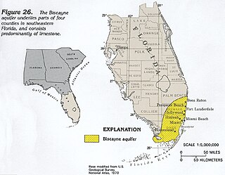
The Biscayne Aquifer, named after Biscayne Bay, is a surficial aquifer. It is a shallow layer of highly permeable limestone under a portion of South Florida. The area it underlies includes Broward County, Miami-Dade County, Monroe County, and Palm Beach County, a total of about 4,000 square miles (10,000 km2).
The Episcopal Diocese of Southwest Florida is a diocese of the Episcopal Church in the United States of America (ECUSA) in Florida which extends from Marco Island on the south, to Brooksville on the north, and inland to Plant City, Arcadia and LaBelle on the east. As part of the ECUSA, the diocese is a constituent member of the worldwide Anglican Communion.
The Torreya Formation is a Miocene geologic formation with an outcrop in North Florida. It is within the Hawthorn Group.
The Coosawhatchie Formation is a Miocene geologic formation with an outcrop in North Florida. It is within the Hawthorn Group.
The Hawthorn Group is a stratigraphic unit of Miocene age in South Carolina, Georgia, and Florida, in the United States. It is known for its phosphate rock resources, and for its rich assemblages of Neogene vertebrate fossils.
The St. Marks Formation is a Miocene geologic formation in the eastern Florida Panhandle.
The Chipola Formation is a Late Oligocene to Early Miocene geologic formation in the Florida Panhandle and member of the Alum Bluff Group.
The Peace River Formation is a Late Oligocene to Early Miocene geologic formation in the west-central Florida peninsula.
The Choctaw Sea was a Cenozoic eutropical subsea, which along with the Okeechobean Sea, occupied the eastern Gulf of Mexico basin system bounding Florida.
Orange Island is the earliest emergent landmass of Florida dating from the middle Rupelian ~33.9—28.4 Ma. geologic stage of the Early Oligocene epoch and named for Orange County, Florida, United States of America.
The Okeechobean Sea was a Cenozoic eutropical subsea, which along with the Choctaw Sea, occupied the eastern Gulf of Mexico basin system bounding Florida.
The Tamiami Formation is a Late Miocene to Pliocene geologic formation in the southwest Florida peninsula.
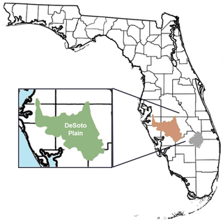
The DeSoto Plain is a major geologic feature of Florida formed during the Miocene epoch and named for DeSoto County, Florida, United States.
The Alum Bluff Group is a geologic group in the states of Georgia, Florida, and Alabama. It preserves fossils dating back to the Neogene period.
The Parachucla Formation is a geologic formation in the southeastern United States. It preserves fossils from the Aquitanian stage of the early Miocene period. The formation is included in the Hawthorn Group. An exposure at the northern end of the formation has produced fossils estimated to be 19.4 to 20.5 Million years ago (Ma). Another exposure at the southern end of the formation has produced fossils estimated to be 23.9 to 24.7 Ma.
The geology of Bahrain is poorly studied before the Cenozoic. Extensive sedimentary formations from the Eocene through recent times cover much of the island.
Compton, John S. (1997). "Origin and Paleoceanographic Significance of Florida's Phosphorite Deposits". In Randazzo, Anthony F.; Jones, Douglas S. (eds.). The Geology of Florida. Gainesville, Florida: University Press of Florida. pp.195–216. ISBN0-8130-1496-4.
Miller, James A. (1997). "Hydrogeology of Florida". In Randazzo, Anthony F.; Jones, Douglas S. (eds.). The Geology of Florida. Gainesville, Florida: University Press of Florida. pp.69–88. ISBN0-8130-1496-4.
Jones, Douglas S. (1997). "The Marine Invertebrate Fossil Record of Florida". In Randazzo, Anthony F.; Jones, Douglas S. (eds.). The Geology of Florida. Gainesville, Florida: University Press of Florida. pp.89–117. ISBN0-8130-1496-4.
Scott, Thomas M. (1997). "Miocene to Holocene History of Florida". In Randazzo, Anthony F.; Jones, Douglas S. (eds.). The Geology of Florida. Gainesville, Florida: University Press of Florida. pp.57–67. ISBN0-8130-1496-4.
This page is based on this Wikipedia article Text is available under the CC BY-SA 4.0 license; additional terms may apply. Images, videos and audio are available under their respective licenses.