
U.S. Route 66 or U.S. Highway 66 was one of the original highways in the United States Numbered Highway System. It was established on November 11, 1926, with road signs erected the following year. The highway, which became one of the most famous roads in the United States, ran from Chicago, Illinois, through Missouri, Kansas, Oklahoma, Texas, New Mexico, and Arizona before terminating in Santa Monica in Los Angeles County, California, covering a total of 2,448 miles (3,940 km).

Ash Fork is a census-designated place in Yavapai County, Arizona, United States. Its population was 396 at the 2010 U.S. Census, down from 457 in 2000.

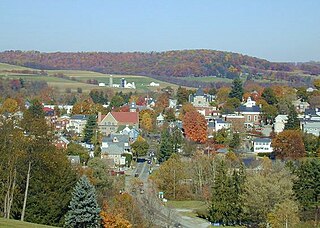
Seligman is a census-designated place (CDP) on the northern border of Yavapai County, in northwestern Arizona, United States. The population was 456 at the 2020 census. It is one of the stops on historic U.S. Route 66.
Ligonier is a borough in Westmoreland County, Pennsylvania, United States. The population was 1,513 at the 2020 census. Ligonier was settled in the 1760s. The borough is well known for nearby Idlewild Park, one of the oldest amusement parks in the country; and nearby Seven Springs Mountain Resort. Another tourist attraction is Fort Ligonier Days, a parade and craft market that takes place every fall over the course of three days, and the Ligonier Country Market in the summer months. Ligonier is part of the Pittsburgh Metropolitan Statistical Area.
U.S. Route 66 in the state of Texas extended across the Texas Panhandle from its designation in 1926 to its decommissioning in 1985.
The historic U.S. Route 66, sometimes known as the Will Rogers Highway after Oklahoma native Will Rogers, ran from west to northeast across the state of Oklahoma, along the path now taken by Interstate 40 (I-40) and State Highway 66 (SH-66). It passed through Oklahoma City, Tulsa, and many smaller communities. West of the Oklahoma City area, it has been largely replaced by I-40; the few independent portions that are still state-maintained are now I-40 Business. However, from Oklahoma City northeast to Kansas, the bypassing I-44 is mostly a toll road, and SH-66 remains as a free alternate.
U.S. Route 66 was a United States Numbered Highway in Illinois that connected St. Louis, Missouri, and Chicago, Illinois. The historic Route 66, the Mother Road or Main Street of America, took long distance automobile travelers from Chicago to Southern California. The highway had previously been Illinois Route 4 and the road has now been largely replaced with Interstate 55 (I-55). Parts of the road still carry traffic and six separate portions of the roadbed have been listed on the National Register of Historic Places.

The Franklin Pierce Homestead is a historic house museum and state park located in Hillsborough, New Hampshire. It was the childhood home of the 14th president of the United States, Franklin Pierce.

Ron George Round Barn is a round barn northeast of the U.S. village of Romeoville, Illinois. It was originally constructed for Frank Eaton c. 1912–13 in Bolingbrook, Illinois.

The Robert Weber Round Barn is a round barn located east of Durand, Illinois, United States along Illinois Route 75 in Harrison Township. The Weber barn was constructed in 1917 and features a roof designed and built by the Haas Brothers, who worked on other area round barns. The barn is 55 feet (17 m) in diameter and features a 24-foot (7.3 m) diameter central silo. The design of the Weber Round Barn stands out from other area round barns in its vitrified tile walls, a development used in later period American round barns. The Robert Weber Round Barn was added to the U.S. National Register of Historic Places in 1984.

Kymulga Mill & Covered Bridge are two locally owned historic landmarks located at Kymulga Park in Talladega County, Alabama, United States. The park is on Grist Mill Road off State Route 76 about 4 miles northeast of the city of Childersburg.

The Ríos-Caledonia Adobe is a historic adobe house in San Miguel, California. Built in 1835 by Petronilo Ríos, the adobe is a California Historical Landmark. Today, the Ríos-Caledonia Adobe is open to the public as a house museum and library.

The Boots Motel, a historic U.S. Route 66 motor hotel in Carthage, Missouri, opened in 1939 as the Boots Court at 107 S. Garrison Avenue.

The Johns Hotel (20IR64) is a complex of buildings, of which but two remain, located near Washington Harbor, on Barnum Island, Isle Royale National Park, Michigan. It was listed on the National Register of Historic Places in 1997.

The former Yonkers Trolley Barn is located on Main Street in Yonkers, New York, United States. It is a massive steel frame brick building in the Renaissance Revival style built at the beginning of the 20th century. In 2002 it was listed on the National Register of Historic Places as the last remaining trolley barn in Westchester County and the only remnant of Yonkers' trolley system.

Laurel Hall and the Laurel Glen Mausoleum form a historic estate property on Vermont Route 103 in Shrewsbury, Vermont. Built between 1880 and 1882, the estate includes examples of high style Queen Anne architecture in the main house and some outbuildings, and includes a distinctive Egyptian Revival mausoleum, all built by John Porter Bowman, a prominent local businessman. The properties were listed on the National Register of Historic Places in 1998.

The M.S. Whitcomb Farm is a historic farm property on United States Route 2 in Richmond, Vermont. Established in the 1850s as a horse farm, it has seen agricultural use in some form since then. Its most distinguishing feature is a large bank barn with a monitor roof, built in 1901. The property, now 170 acres (69 ha), was listed on the National Register of Historic Places in 1993.

The West View Farm is a historic farm property on Hastings Road in Waterford, Vermont. The farm is unique for its distinctive round barn, built in 1903 to a design by St. Johnsbury architect Lambert Packard, and surviving 19th-century corn crib and smokehouse. The property was listed on the National Register of Historic Places in 1995. It includes a round barn.


