
The Konkan, also Concan or Kokan, is a stretch of land by the western coast of India, running from Damaon in the north to Anjediva in the south; with the Arabian Sea to the west and the Deccan plateau in the east. The hinterland east of the coast has numerous river valleys and riverine islands among the hilly slopes leading up into the tablelands of the Deccan. The region has been recognised by name, since at least the time of Strabo in the third century C.E., and was a thriving mercantile port with Arab tradesmen from the 10th century. The best-known islands of Konkan are Ilhas de Goa, the site of the Goa state's capital at Panjim, and the seven islands of Bombay, on which lies the capital of the state of Maharashtra.main kokan starts from Alibag and ends with goa. There is most sacred place in kokan of goddess padmakshi renuka temple in Alibag, this goddess is shaktipeeth among 108 peethas where sati goddess brain part is fallen. some people also recommend that devi sati's nails fallen but this goddess is also called goddess of kokan.
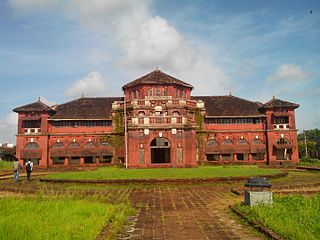
Ratnagiri is a port city on the Arabian Sea coast in Ratnagiri District in the southwestern part of Maharashtra, India. The district is a part of Konkan division of Maharashtra. The city is known for the Hapus or Alphonso mangoes. Ratnagiri is the birthplace of Indian independence activist Lokmanya Tilak. Thibaw, the last king of Burma, alongside his consort Supayalat and two infant daughters were exiled to a two-storied brick mansion in Ratnagiri. The building is now known as Thibaw Palace.

Ganpatipule is a costal town in Ratnagiri district of Maharashtra. Due to its Ganpati mandir the town is popular Hindu pilgrimage and tourists destination.
Sindhudurg district is an administrative district of the Konkan division in India, which was carved out of the erstwhile Ratnagiri district. The district headquarters are located at Oros and the district occupies an area of approximately 5,207 km2 and has a population of 849,651, of which 12.59% were urban. As of 2011, it's the least populous district of Maharashtra.

Khed is a municipal council in the Ratnagiri district of the state of Maharashtra, India. Khed town is situated on the Mumbai - Ratnagiri Highway.
Malvanpronunciation (help·info) is a town and taluka in Sindhudurg District, the southernmost district of Maharashtra State, India, well known for the historically important Sindhudurg Fort. Malvan taluka consists of villages such as Angane Wadi, Masure, Achra, Khalchi Devli, Jamdul, Juva, Pankhol, Talasheel and Sarjekot. The main occupation here is fishing and agriculture. The staple diet of the local people is fish curry and rice. The town produces Alphonso mangoes and is also known for sweets such as Malvani Khaja made from gram-besan flour and coated jaggery as well as Malvani Ladoos. Other sweets that attract tourists are Konkani Meva, Aambawadi, Fanaspoli, Kajuwadi, and Naralachya Wadya.

Dapoli is a town in Ratnagiri district, Maharashtra which is also a coastal hill station. It lies 215 km (134 mi) south of the state capital of Mumbai. the town is also known as Camp Dapoli, as the British had set their camps here. Many high-ranking British officers' graves are found in this town. There is also an abandoned church from the time of the British Raj. Dapoli is administered by a Municipal Council.

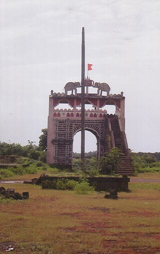
Mahad is a city in Raigad district situated in the North Konkan region of Maharashtra state, India. It is located 108.5 km (67.4 mi) from District's headquarter Alibag, and 167 km (104 mi) from Mumbai. Mahad is known for Raigad Fort, the capital of the Maratha Empire in Shivaji's era and the revolutionary Mahad Satyagraha launched by at Chavdar Tale in the wake of modern India.
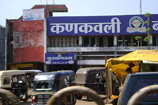
Kankavli is a city in Sindhudurg district in the Indian state of Maharashtra. It is an important city due to its central location in the Sindhudurg district. All talukas are at an equal distance from Kankavli city. There is a temple of Shri Bhalchandra Maharaj and Swyambhu Ravalnath. The Kankavli city is situated in between two west flowing rivers which carry roaring gushing waters on their rockbed to Arabian sea in monsoon. It is a culturally, educationally and socially rich and vibrant major city. A veteran Gandhian Shri Appasaheb Patwardhan founded Gopuri Ashram near Kankavli city with principles of Swadeshi, Swatchhata, Swawlamban and Sarvodaya in 1948. Kankavli is equally located from Kolhapur and Ratnagiri. This is one of the important railway stations on Konkan railway route and major towns on NH 66. Cabinet Minister Shri. Narayan Rane also hails from this area.

Kurang is a small village]in the Ratnagiri district of Maharashtra in India. Ratnagiri is a coastal district on the Arabian Seafront.
Mandangad is the headquarters of Mandangad taluka the northmost taluka in Ratnagiri district of Maharashtra, India.
Sangameshwar Taluka is a taluka in Ratnagiri subdivision of Ratnagiri district in the Indian state of Maharashtra. The headquarters for the taluka is the town of Devrukh. In Sangameshwar the two rivers Sonavi and Shastri flow together. The meaning of Sangama in Marathi is confluence, and so the name "Sangameshwar". It is historically important as the place where Chhatrapati Sambhaji, son of Chhatrapati Shivaji was captured by Mughal Emperor Aurangzeb. Chhatrapati Sambhaji was tortured and executed in Tulapur.
Devhare is in Mandangad taluka about 210 km from Mumbai by road. All state transport buses go through the Devhare. Devhare is scenic and surrounded with hills. The normal temperature of Devhare is around 26 °C. In month of April and may go around 42 degrees. Devhare is relatively undiscovered as a tourist destination. The Scenic beach of Kelshi is about 15 km from Devhare. A ferry from Bankot can take you to Harihareshwar and Shriwardhan, the ferry ride is very scenic.
Saitavde, or Saitawada, is a small village on the Jaigad creek in Ratnagiri district. It is about 390 km southwest of Mumbai, and about 58 km to the north of Ratnagiri city.
Satawali is a census town in Lanja-Taluka Ratnagiri district in the Indian state of Maharashtra.
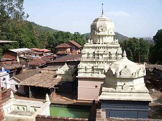
Parshuram Temple is a temple of Lord Parshurama, the sixth avatar of Vishnu in Hinduism located near Chiplun in Ratnagiri district of Maharashtra, India.
Rameshwar also known as Rameshwar Wadi is a small town located on the coast of Sindhudurg District of Maharashtra on the west coast of India. A very old Shri Dev Rameshwar Temple is located in this town which is dedicated to the Hindu deity Shiva.

Ratnagiri Fort, also called Ratnadurg Fort or Bhagawati Fort, is a fort located 2 km from Ratnagiri, in Ratnagiri district, of Maharashtra. This fort is an important fort in Ratnagiri district. The fort is a main tourist attraction due to the Bhagawati Temple inside the fort.
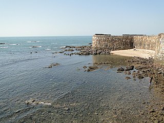
Sarjekot Fort is an old military fortification in India. it is situated very close to the Malvan..It is located in the Arabian Sea close to the Malvan town in Sindhudurg District of Maharashtra state.
Padargad is a small fort used for vigilance in the past. is situated to the east of Karjat in the Indian state of Maharashtra. It is on the Bhimashanker trek route in the Karjat area, because of its height and difficult climbing, it is not visited by most of the trekkers.

