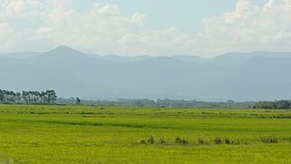
The Argentine Monte (NT0802), or Low Monte, is an ecoregion of dry thorn scrub and grasslands in Argentina. It is one of the driest regions in the country. Human settlements are mainly near water supplies such as rivers or oases. Deforestation and over-grazing around these settlements have caused desertification.
The Argentine Monte is in north-central Argentina, and has an area of 354,192 square kilometres (136,800sqmi).[1] It is to the east of the Andes and extends from Salta Province in the north to Chubut Province in the south.[2] It extends from the eastern foothills of the Andes to the Atlantic Ocean. The ecoregion merges into the Patagonian steppe in the south and southwest. The Dry Chaco lies to the northeast, and the Espinal is to the east.[1]
In the northwest it borders the High Monte. Some consider the High Monte a separate ecoregion,[1] while others consider it a part of the Argentine Monte.[3]
The ecoregion is by far the driest part of Argentina.[4] The Köppen climate classification is "BSk": arid, steppe, cold arid.[6] Annual precipitation is 80 to 250 millimetres (3.1 to 9.8in).[2] In the north and central regions there is more rain in summer. In the colder south the monthly rainfall is more evenly distributed.[2] At a sample location at coordinates 38°15′S67°15′W / 38.25°S 67.25°W / -38.25; -67.25 the mean temperature ranges from 6.3°C (43.3°F) in July to 23.1°C (73.6°F) in January. The yearly average mean temperature is 15°C (59°F). Annual precipitation is about 175 millimetres (6.9in). Monthly precipitation ranges from 5.4 millimetres (0.21in) in July to 25.7 millimetres (1.01in) in October.[6]
Flora are typically thorn scrub and dry grassland, with relatively low plant diversity. There are thin gallery forests along the rivers.[4] There are areas of cactus scrub, xerophilous open woodland, and vegetation adapted to rocky, sandy and salty conditions.[2] In some areas the scrub is very open. The steppe contains resinous evergreen bushes, mainly from the family Zygophyllaceae and the genera Larrea, Bulnesia and Plectocarpa. Other species are Monttea aphylla, Bougainvillea spinosa and Prosopis species.[2]
The World Wildlife Fund gives the ecoregion the status of "Vulnerable".[3] The region has mostly been settled by people only in oases or areas near rivers where irrigation-based agriculture is possible. This process began in the late 19th century and continues today. The habitat in the settled areas has been greatly changed, with trees cleared for use as fuel and lumber and to make way for agriculture and mineral exploitation. 580,000 square kilometres (220,000sqmi) of the ecoregion has been affected by erosion caused by deforestation and excessive grazing by sheep, goats and cattle. There is marked increase in desert areas, affecting the habitats of many native species. Many species are affected by fragmentation of their habitats.[2]
The Guanacache, Desaguadero y Bebedero system has been affected by various natural and man-made changes that have caused the area of lagoons and marshes to shrink significantly. Some efforts are being made to rehabilitate them.[5]
"Low Monte", Global Species, Myers Enterprise II, retrieved 2017-04-12
Related Research Articles
The Pampas are fertile South American low grasslands that cover more than 1,200,000 square kilometres (460,000 sq mi) and include the Argentine provinces of Buenos Aires, La Pampa, Santa Fe, Entre Ríos, and Córdoba; all of Uruguay; and Brazil's southernmost state, Rio Grande do Sul. The vast plains are a natural region, interrupted only by the low Ventana and Tandil hills, near Bahía Blanca and Tandil (Argentina), with a height of 1,300 m (4,265 ft) and 500 m (1,640 ft), respectively.
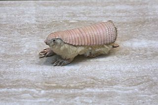
The pink fairy armadillo is the smallest species of armadillo, first described by Richard Harlan in 1825. This solitary, desert-adapted animal is endemic to central Argentina and can be found inhabiting sandy plains, dunes, and scrubby grasslands.
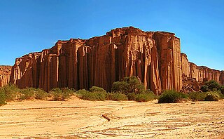
Talampaya National Park is a national park located in the east/centre of La Rioja Province, Argentina. It was designated a provincial reserve in 1975, a national park in 1997, and a UNESCO World Heritage Site in 2000.
The Monte Desert is a South American desert, lying entirely within Argentina and covering approximately the submontane areas of Catamarca, La Rioja, San Juan, San Luis and Mendoza Provinces, plus the western half of La Pampa Province and the extreme north of Río Negro Province. The desert lies southeast of the Atacama Desert in Chile and Peru, north of the larger Patagonian Desert, east of the Andes and west of the Sierra de Córdoba.
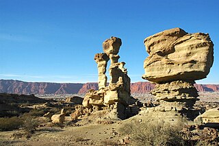
The Sierra de las Quijadas National Park is a national park located in the northwestern part of the Argentine province of San Luis. It was established on December 10, 1991, to protect the natural features, representative of the Semiarid Chaco and the High Monte ecoregions.
The Southern Andean Yungas is a tropical and subtropical moist broadleaf forest ecoregion in the Yungas of southwestern Bolivia and northwestern Argentina.
The Marajó várzea (NT0138) is an ecoregion of seasonally and tidally flooded várzea forest in the Amazon biome. It covers a region of sedimentary islands and floodplains at the mouth of the Amazon that is flooded twice daily as the ocean tides push the river waters onto the land. The flooded forests provide food for a wide variety of fruit-eating fish, aquatic mammals, birds and other fauna. It has no protected areas and is threatened by cattle and water-buffalo ranching, logging and fruit plantations.
The Monte Alegre várzea (NT0141) is an ecoregion of seasonally flooded várzea forest along the Amazon River in the Amazon biome.
The Purus-Madeira moist forests (NT0157) is an ecoregion in the central Amazon basin. It is part of the Amazon biome. The ecoregion covers a stretch of flat and relatively infertile land between the Purus and Madeira rivers, extending to the Solimões River in the north. It is isolated from other regions by the seasonally flooded várzea forest along these rivers, and has a high degree of endemism among its flora and fauna. The natural environment is relatively intact. The BR-319 highway was built along the length of the ecoregion in the early 1970s, but rapidly deteriorated and is now closed.
The Xingu–Tocantins–Araguaia moist forests (NT0180) is an ecoregion in the eastern Amazon basin. It is part of the Amazon biome. The ecoregion is one of the most severely degraded of the Amazon region, suffering from large-scale deforestation and selective extraction of timber, particularly along the Trans-Amazonian Highway and in the higher and more populated southern portions.
The Tocantins–Araguaia–Maranhão moist forests (NT0170), also called the Tocantins/Pindaré moist forests, is an ecoregion in the north of Brazil to the south of the mouth of the Amazon River. It is part of the Amazon biome. The ecoregion contains the city of Belém, capital of the state of Pará. It is the most developed part of the Amazon region, and is one of the most severely degraded natural habitats of the region.
The Solimões-Japurá moist forests (NT0163) is an ecoregion in northwest Brazil and eastern Peru and Colombia in the Amazon biome. It has a hot climate with high rainfall throughout the year, and holds one of the most diverse collections of fauna and flora in the world. The ecoregion is relatively intact.
The Paraná flooded savanna (NT0908) is an ecoregion that borders the southern Paraná River in Argentina. It has largely been converted to agriculture or occupied by urban development, but scattered patches of the original habitat remain along the river.
The Espinal (NT0801) is an ecoregion of dry, thorny forest, savanna and steppe in Argentina. It has been extensively modified by large scale cattle ranching, but remnants of the original flora remain. It is threatened by the advance of the irrigation-based agricultural frontier.
The Patagonian grasslands (NT0804) is an ecoregion in the south of Argentina and Chile. The grasslands are home to diverse fauna, including several rare or endemic species of birds. There are few protected areas. The grasslands are threatened by overgrazing by sheep, which supply high-quality merino wool. Efforts are being made to develop sustainable grazing practices to avoid desertification.
The Cordillera Central páramo (NT1004) is an ecoregion containing páramo vegetation above the treeline in the Andes mountain range of northern Peru and southern Ecuador. Due to its isolation there are high levels of endemism. Despite many human settlements and some destruction of habitat by agriculture and mining, the ecoregion is relatively intact.
The Paraguana xeric scrub (NT1313) is an ecoregion in Venezuela to the north and east of Lake Maracaibo and along the coast of Aruba, Bonaire, and Curaçao. The region holds flora and fauna adapted to the very dry conditions of the coastal dunes and inland areas of bush, scrub, briars and cacti. There are several endangered species of animals and birds. Efforts at protecting the environment have been ineffective. Most of the original trees have been cut down, dunes are being destabilized by loss of vegetation, scrub is replaced by farmland and vegetation is destroyed by grazing goats.
The Araya and Paria xeric scrub (NT1301) is an ecoregion in Venezuela that stretches along the Caribbean coast to the west of Trinidad, and that includes Margarita Island and some smaller islands. The ecoregion includes dune herbs, dry thorn scrubs and deciduous forests. The mountains on Margarita Island hold montane forests similar to those in the mainland coastal range. The beaches are used for breeding by sea turtles. Some endemic bird species are threatened with extinction by illegal capture for the pet trade. Deforestation and over-grazing by goats are also problems.
The Bolivian montane dry forests (NT0206) is an ecoregion in Bolivia on the eastern side of the Andes. It is a transitional habitat between the puna grasslands higher up to the west and the Chaco scrub to the east. The habitat is under severe stress from a growing human population.
The High Monte is a montane grasslands and shrublands ecoregion in Argentina.
This page is based on this Wikipedia article Text is available under the CC BY-SA 4.0 license; additional terms may apply. Images, videos and audio are available under their respective licenses.