Inyo County is a county in the eastern central part of the U.S. state of California, located between the Sierra Nevada and the state of Nevada. In the 2020 census, the population was 19,016. The county seat is Independence. Inyo County is on the east side of the Sierra Nevada and southeast of Yosemite National Park in Central California. It contains the Owens River Valley; it is flanked to the west by the Sierra Nevada and to the east by the White Mountains and the Inyo Mountains. With an area of 10,192 square miles (26,400 km2), Inyo is the second-largest county by area in California, after San Bernardino County. Almost one-half of that area is within Death Valley National Park. However, with a population density of 1.8 people per square mile, it also has the second-lowest population density in California, after Alpine County.

The Panamint Range is a short rugged fault-block mountain range in the northern Mojave Desert, within Death Valley National Park in Inyo County, eastern California. Dr. Darwin French is credited as applying the term Panamint in 1860 during his search for the fabled Gunsight Lode. The orographic identity has been liberally applied for decades to include other ranges.

The Spring Mountains are a mountain range of Southern Nevada in the United States, running generally northwest–southeast along the west side of Las Vegas and south to the border with California. Most land in the mountains is owned by the United States Forest Service and the Bureau of Land Management and managed as the Spring Mountains National Recreation Area within the Humboldt-Toiyabe National Forest and the Red Rock Canyon National Conservation Area.
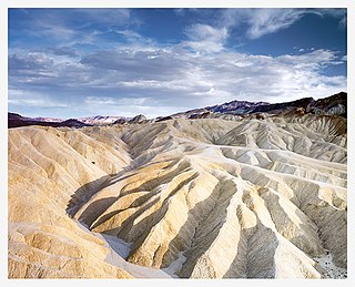
Places of interest in the Death Valley area are mostly located within Death Valley National Park in eastern California.

Searles Lake is an endorheic dry lake in the Searles Valley of the Mojave Desert, in northwestern San Bernardino County, California. The lake in the past was also called Slate Range Lake and Borax Lake.
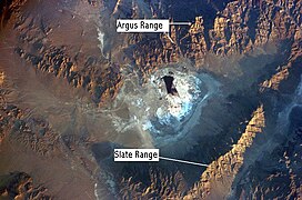
The Coso Range of eastern California is located immediately south of Owens Lake, east of the Sierra Nevada, and west of the Argus Range. The southern part of the range lies in the restricted Naval Air Weapons Station China Lake and the northern part of the range is designated as the Coso Range Wilderness. The mountains include Coso Peak, at 8,160 feet (2,487 m) above sea level, as well as Silver Peak and Silver Mountain, both more than 7,400 ft (2,300 m) in height.

Panamint City is a ghost town in the Panamint Range, near Death Valley, in Inyo County, California, US. It is also known by the official Board of Geographic Names as Panamint. Panamint was a boom town founded after silver and copper were found there in 1872. By 1874, the town had a population of about 2,000. Its main street was one mile (1.6 km) long. Panamint had its own newspaper, the Panamint News. Silver was the principal product mined in the area. The town is located about three miles northwest of Sentinel Peak. According to the National Geographic Names Database, NAD27 latitude and longitude for the locale are 36°07′06″N117°05′43″W, and the feature ID number is 1661185. The elevation of this location is identified as being 6,280 feet AMSL. The similar-sounding Panamint Springs, California, is located about 25.8 miles at 306.4 degrees off true north near Panamint Junction.
The Timbisha are a Native American tribe federally recognized as the Death Valley Timbisha Shoshone Band of California. They are known as the Timbisha Shoshone Tribe and are located in south central California, near the Nevada border. As of the 2010 Census the population of the Village was 124. The older members still speak the ancestral language, also called Timbisha.

The Hualapai Mountains are a mountain range located in Mohave County, east of Kingman, Arizona. Rising up to 8,417 feet at its highest peak, the higher elevations of the Hualapai Mountains support Madrean Sky Island habitats, and are host to a plethora of unique flora and fauna in a wide range of microclimates, high above the surrounding Mojave Desert.
The Big Maria Mountains are located in the southeastern part of the U.S. state of California, near the Colorado River and Arizona. The range lies between Blythe and Vidal, and west of U.S. Route 95 in California and east of Midland. The mountains are home to the Eagle Nest Mine and reach an elevation of 1,030 meters, (3,379 ft). A power line that runs from Parker Dam to Yuma, Arizona runs through the range. A smaller range, the Little Maria Mountains, lie to the west of the Big Marias.
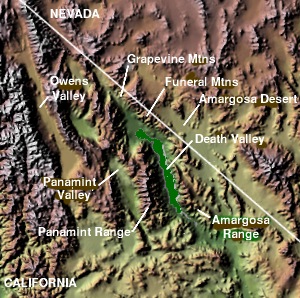
The Panamint Valley is a long basin located east of the Argus and Slate ranges, and west of the Panamint Range in the northeastern reach of the Mojave Desert, in eastern California, United States.

The Darwin Falls Wilderness is a protected area in the northern Mojave Desert adjacent to Death Valley National Park. The 8,189-acre (3,314 ha) wilderness area was created by the California Desert Protection Act of 1994 and is managed by the Bureau of Land Management as part of the National Wilderness Preservation System.

Coso Rock Art District is a rock art site containing over 100,000 Petroglyphs by Paleo-Indians and/or Native Americans. The district is located near the towns of China Lake and Ridgecrest, California. Big and Little Petroglyph Canyons were declared a National Historic Landmark in 1964. In 2001, they were incorporated into this larger National Historic Landmark District. There are several other distinct canyons in the Coso Rock Art District besides the Big and Little Petroglyph Canyons. Also known as Little Petroglyph Canyon and Sand Tanks, Renegade Canyon is but one of several major canyons in the Coso Range, each hosting thousands of petroglyphs. The majority of the Coso Range images fall into one of six categories: bighorn sheep, entopic images, anthropomorphic or human-like figures, other animals, weapons & tools, and "medicine bag" images. Scholars have proposed a few potential interpretations of this rock art. The most prevalent of these interpretations is that they could have been used for rituals associated with hunting.

The Kiavah Wilderness is a federally designated wilderness area located in the Mojave Desert, Scodie Mountains, and southern Sierra Nevada in Kern County, California, United States. California State Route 178 connects the town of Lake Isabella to State Highway 14 in the east, crossing Walker Pass at the north boundary of the wilderness.

The Sacatar Trail Wilderness is a federally designated wilderness area located 20 miles (32 km) northwest of Ridgecrest, California USA. It was created in 1994 with the passage of the California Desert Protection Act - Public Law 103-433 - and is managed by the Bureau of Land Management (BLM). The wilderness is 51,900 acres (210 km2) in size and protects portions of the southern Sierra Nevada Mountain Range.
The Piper Mountain Wilderness is a federally designated wilderness area located in the White Mountains 20 miles (32 km) northeast of Big Pine, California in Inyo County, California.
The Sylvania Mountains Wilderness is a federally designated wilderness area located 30 miles (48 km) east of Bishop in the state of California. The wilderness is 18,677acres in size and is managed by the Bureau of Land Management (BLM). The California Desert Protection Act of 1994 created the Sylvania Mountains Wilderness and was added to the National Wilderness Preservation System. The wilderness is bordered by Nevada stateline on the east, Piper Mountain Wilderness on the west and Death Valley National Park to the south.
The Whipple Mountains Wilderness is a 76,122-acre (30,805 ha) wilderness administered by the Bureau of Land Management (BLM). Most of the Whipple Mountains are within the wilderness area. It is located in the northeastern Colorado Desert near the Colorado River. Lake Havasu and Lake Havasu City are 25 miles (40 km) to the North. Earp, California and Parker, Arizona are 20 miles (32 km) to the South. The Parker Dam is 8 miles (13 km) due east.

The Colorado River is a major river of the western United States and northwest Mexico in North America. Its headwaters are in the Rocky Mountains where La Poudre Pass Lake is its source. Located in north central Colorado it flows southwest through the Colorado Plateau country of western Colorado, southeastern Utah and northwestern Arizona where it flows through the Grand Canyon. It turns south near Las Vegas, Nevada, forming the Arizona–Nevada border in Lake Mead and the Arizona–California border a few miles below Davis Dam between Laughlin, Nevada and Needles, California before entering Mexico in the Colorado Desert. Most of its waters are diverted into the Imperial Valley of Southern California. In Mexico its course forms the boundary between Sonora and Baja California before entering the Gulf of California. This article describes most of the major features along the river.

Coso Peak is the highest summit in the Coso Range, a small mountain range east of the Sierra Nevada, in Inyo County in the U.S. state of California. The peak has an elevation of 8,157 feet and a topographic prominence of 2,489 ft (759 m), making it the 88th most prominent mountain in California.