Arizona State Route 88

Last updated

Arizona 88.svg

State Route 88

Arizona State Route 88
SR 88 highlighted in red
Route information
Maintained by ADOT
Length45.67 mi [1]  (73.50 km)
Existed1927–present
Tourist
routes
Arizona Scenic Road Marker.svg Apache Trail Historic Road
Major junctions
West endUS 60.svg US 60 in Apache Junction
East endArizona 188.svg SR 188 near Theodore Roosevelt Lake
Location
Country United States
State Arizona
Counties Pinal, Maricopa
Highway system
  • Arizona State Highway System
Arizona 87.svg SR 87 US 89.svg US 89

State Route 88 is a long state highway in the U.S. state of Arizona. It runs from U.S. Route 60 (US 60) in Apache Junction through desert terrain to SR 188 near Roosevelt Dam. Following the Salt River for much of its length, the section east of Tortilla Flat is known as the Apache Trail and is part of the National Forest Scenic Byway system. The Apache Trail was built in the mid-1920s, and the number 88 was assigned in 1927. An eastern extension of State Route 88 to Globe, Arizona was redesignated as State Route 188 on August 20, 1999.

Contents

Route description

State Route 88 at Tortilla Flat Tortilla Flat 02.jpg
State Route 88 at Tortilla Flat

SR 88 begins at a diamond interchange with US 60, the Superstition Freeway, in southern Apache Junction. The route follows Idaho Road northward through a residential area with four lanes. Following a junction with Old West Highway, SR 88 turns northeast onto Apache Trail and narrows to two lanes. The route exits the city limits of Apache Junction, entering desert terrain. Passing a ghost town known as Goldfield, Apache Trail enters Tonto National Forest just northwest of Lost Dutchman State Park. SR 88 nears Canyon Lake south of the Mormon Flat Dam and follows a part of the southern shore of Canyon Lake. Apache Trail heads away from the Salt River. It passes through the town of Tortilla Flat, becoming an unpaved dirt trail winding eastward through the Superstition Mountains. SR 88 again turns northeast and nears Apache Lake. The route follows the Salt River northeast to the Theodore Roosevelt Dam, near which the route is again paved. SR 88 intersects with SR 188 along the coast of Theodore Roosevelt Lake. [2]

The highway is maintained by the Arizona Department of Transportation (ADOT), which is responsible for maintaining highways in the state, including SR 88. As part of this role, ADOT periodically surveys traffic along its routes. These surveys are presented in the form of average annual daily traffic, which is the number of vehicles who use the route on any average day during the year. In 2009, ADOT calculated that around as few as 400 vehicles used the route daily near the Roosevelt Dam and as many as 16,000 daily at the US 60 interchange in Apache Junction. [3] The section east of Canyon Lake is part of the Apache Trail National Forest Scenic Byway system. [4] No part of the highway has been listed in the National Highway System, [5] a system of roads in the United States important to the nation's economy, defense, and mobility. [6] Part of SR 88, known as the Apache Trail Historic Road, is one of only four state designated Historic Roads under the Arizona Parkways, Historic and Scenic Roads program. [7] [8]

Following the 2019 Woodbury Fire and subsequent damage to the unpaved portion of the route, the road is closed indefinitely from milepost 222 to 229 (Roughly midway from Tortilla Flat to Roosevelt Dam) [9] until a plan to revamp the seven-mile closure is implemented. SR 88 is not a major route between Apache Junction and Roosevelt Lake and has a very low traffic count, so it is likely it is not a priority project for the Arizona Department of Transportation. There is access to all the Salt River lakes impacted by the closure. Canyon Lake can be accessed from Apache Junction while Roosevelt and Apache Lakes are accessed through Globe or via State Highway 87, south of Rye, Arizona.

History

SR 88 highway shield upon designation in 1927. Arizona 88 1927.svg
SR 88 highway shield upon designation in 1927.
SR 88 near Fish Creek Hill Apache Trail 06.jpg
SR 88 near Fish Creek Hill

The Apache Trail connected the Old Spanish Trail where Apache Junction is today and Roosevelt Lake with an unpaved road as early as 1925, following much of the modern route. [10] [11] By the next year, SR 66 followed the Apache Trail and the Old Spanish Trail was numbered as US 80. [12] The number 88 was given to the route by 1927, but continued past its current terminus east to US 180 west of Globe. [13] US 60 and US 89 became concurrent with US 80 at the western terminus by 1935, [14] and the US 70 designation was added to the road by 1939. [15] The section of the route from Apache Junction to Canyon Lake was paved in the late 1940s. [16] [17] By 1958, the section east of Roosevelt Dam was paved. [18] The extra designations at SR 88's western terminus were removed by 1971, leaving only the US 60 designation. [19] August 20, 1999, the section east of Roosevelt Dam was renumbered as SR 188, cutting SR 88 back to its current terminus. [20]

Junction list

CountyLocationmi [1] kmDestinationsNotes
Pinal Apache Junction 0.000.00US 60.svg US 60 (Superstition Freeway) Phoenix, Globe Interchange; western terminus; exit 196 on US 60; continues south as Idaho Road
1.842.96Old West Highway (Historic US 80)
Maricopa 45.6773.50Arizona 188.svg SR 188  Payson, Globe Eastern terminus; former southern terminus of SR 188; Apache Trail continues east as SR 188 south (former SR 88 east)
1.000 mi = 1.609 km; 1.000 km = 0.621 mi

See also

Related Research Articles

<span class="mw-page-title-main">Interstate 17</span> Interstate Highway in central Arizona

Interstate 17 (I-17) is a north–south Interstate Highway entirely within the US state of Arizona. I-17's southern terminus lies in Phoenix, at I-10/US 60 and its northern terminus is in Flagstaff, at Milton Road north of I-40.

<span class="mw-page-title-main">Arizona State Route 89A</span> State highway in Arizona, United States

State Route 89A is an 83.85-mile (134.94 km) state highway that runs from Prescott north to Flagstaff in the U.S. state of Arizona. The highway begins at SR 89 in Yavapai County and heads northward from Prescott Valley, entering Jerome. From Jerome, the route then heads to Cottonwood and Clarkdale. The road then continues out to Sedona. The highway is notable for its scenic value as it winds over and through Mingus Mountain as well as passing through Sedona and the Oak Creek Canyon. The route then enters Coconino County soon after leaving Sedona. The highway proceeds to Flagstaff, where it crosses Interstate 17 (I-17) and I-40. The highway ends at I-40 Business in Flagstaff. What is now SR 89A became a state highway in the late 1920s as SR 79. The highway was extended and improved several times through 1938. SR 79 was renumbered to U.S. Route 89A in 1941 and then to SR 89A in the early 1990s.

<span class="mw-page-title-main">Apache Trail</span> Historic stagecoach trail in Arizona

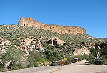
The Apache Trail in Arizona was a stagecoach trail that ran through the Superstition Mountains. It was named the Apache Trail after the Apache Indians who originally used this trail to move through the Superstition Mountains.

<span class="mw-page-title-main">Canyon Lake (Arizona)</span> Waterbody in Maricopa County, Arizona

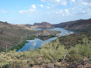
Canyon Lake is one of four reservoirs that were formed by the damming of the Salt River in the U.S. state of Arizona as part of the Salt River Project. It was formed by the Mormon Flat Dam, which was completed in 1925 after two years of construction. Canyon Lake, with a surface area of 950 acres (380 ha), is the third and smallest of the four lakes created along the river. Two others, Apache Lake and Roosevelt Lake, are upstream. The fourth, Saguaro Lake, is downstream.

<span class="mw-page-title-main">U.S. Route 89A</span> Highway in Arizona and Utah

U.S. Route 89A is a 91.74-mile (147.64 km) north–south auxiliary U.S. highway in southwestern Kane County, Utah and northeastern Coconino County, Arizona in the southwestern United States. The highway is an old routing of U.S. Route 89 from Bitter Springs, Arizona to Kanab, Utah. The state of Arizona has designated this highway the Fredonia-Vermilion Cliffs Scenic Road. The highway is used to access the North Rim of Grand Canyon National Park and is known for the Navajo Bridge. Until 2008, the Utah portion was signed State Route 11. The route provides the only direct road connection between the Arizona Strip and the rest of Arizona.

<span class="mw-page-title-main">Arizona State Route 67</span> State highway in Arizona, United States

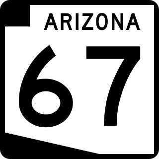
State Route 67 is a 43.4 mi (69.8 km) long, north–south state highway in northern Arizona. Also called the Kaibab Plateau – North Rim Parkway, SR 67 is the sole road that links U.S. Route 89A at Jacob Lake to the North Rim of Grand Canyon National Park. Along the route, the road heads through the national park as well as Kaibab National Forest and traverses extensive coniferous forests. The section inside the national park is maintained by the National Park Service (NPS), whereas the section north of the entrance, completely within Kaibab National Forest, is owned by the Arizona Department of Transportation (ADOT). The road was built in the late 1920s and improved through the 1930s. In 1941, the road received its number, and was given its designation as the parkway in the 1980s. The parkway has received designations as a National Forest Scenic Byway as well as a National Scenic Byway.

<span class="mw-page-title-main">Arizona State Route 83</span> State highway in Arizona, United States

State Route 83 is a scenic state highway in southern Arizona, stretching from its junction with Interstate 10 near Vail south to Parker Canyon Lake. It passes through sparsely populated areas of Pima, Cochise and Santa Cruz Counties, passing through the wine towns of Sonoita and Elgin.

<span class="mw-page-title-main">Arizona State Route 473</span> State highway in Arizona, United States

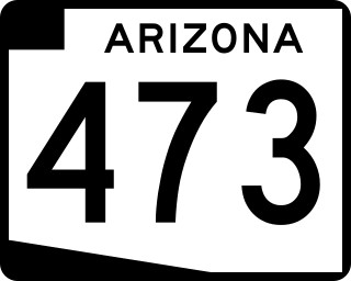
State Route 473, also known as SR 473, is a state highway in east-central Arizona, United States, that travels from State Route 260 to Hawley Lake. Hawley Lake is almost always the coldest place in Arizona.

<span class="mw-page-title-main">Arizona State Route 188</span> State highway in Arizona, United States

State Route 188 is a 60.85-mile (97.93 km) state highway located primarily in Gila County in the U.S. state of Arizona.

<span class="mw-page-title-main">Arizona State Route 98</span> State highway in Arizona, United States

State Route 98 is a state highway in Coconino County in the U.S. state of Arizona.

<span class="mw-page-title-main">Arizona State Route 261</span> State highway in Arizona, United States

State Route 261 is a highway in Apache County, Arizona that runs from its junction with SR 260 west of Eagar to its junction with SR 273 north of Big Lake. It winds through the forest but is overall a north–south route.

<span class="mw-page-title-main">Arizona State Route 289</span> State highway in Arizona, United States

State Route 289 is a highway in Santa Cruz County, Arizona that runs from its junction with Interstate 19 to the north of Nogales, to Peña Blanca Lake. It is an east–west route.

<span class="mw-page-title-main">U.S. Route 60 in Arizona</span> Section of U.S. Highway in Arizona, United States

U.S. Route 60 (US 60) is an east–west United States Highway within Arizona. The highway runs for 369 miles (594 km) from a junction with Interstate 10 near Quartzsite to the New Mexico state line near Springerville. As it crosses the state, US 60 overlaps at various points: I-17, I-10, SR 77, SR 260, US 191, and US 180. Between Wickenburg and Phoenix, the route is known as Grand Avenue. From Tempe to Apache Junction, it is known as the Superstition Freeway.

<span class="mw-page-title-main">U.S. Route 191 in Arizona</span> Section of U.S. Highway in Arizona, United States

U.S. Route 191 (US 191) is a north–south U.S. Highway in eastern Arizona. The highway runs for 516.50 miles (831.23 km), making it Arizona's longest numbered highway. The highway begins at State Route 80 near Douglas and crosses over the Utah state line near Mexican Water in the Navajo Nation. Between Douglas and Utah, US 191 shares multiple concurrencies with I-10, US 70, US 180, US 60, SR 61, I-40, SR 264, and US 160.

<span class="mw-page-title-main">U.S. Route 93 in Arizona</span> Highway in Arizona

U.S. Route 93 (US 93) is a United States Numbered Highway in the state of Arizona that begins in Wickenburg and heads north to the Nevada state line at the Mike O'Callaghan–Pat Tillman Memorial Bridge. The total length of US 93 in Arizona is 199.38 miles. Between Wickenburg and Interstate 40 (I-40), part of US 93 is designated as the Joshua Forest Scenic Byway. While most of US 93 is a four-lane divided highway, sections of the highway between Wickenburg and I-40 are still narrow two-lane roads, gradually being upgraded to match the rest of the route. As part of a proposal by municipal leaders in Nevada and Arizona, the highway could be replaced by Interstate 11 (I-11).

<span class="mw-page-title-main">U.S. Route 89 in Arizona</span> Section of U.S. Highway in Coconino County, Arizona, United States

U.S. Route 89 (US 89) is a U.S. Highway in the U.S. state of Arizona that begins in Flagstaff and heads north to the Utah border northwest of Page. US 89 is among the first U.S. Highways established in Arizona between November 11, 1926 and September 9, 1927. Until 1992, US 89 started at the international border in Nogales and was routed through Tucson, Phoenix and Prescott between Nogales and Flagstaff. State Route 79 and State Route 89 are both former sections of US 89.

<span class="mw-page-title-main">U.S. Route 70 in Arizona</span> Highway in Arizona

U.S. Route 70 (US 70), also known as the Old West Highway, is an east–west U.S. Highway in the U.S. state of Arizona. The current route starts at US 60 in Globe and runs through the San Carlos Indian Reservation, Safford and Duncan into New Mexico near Virden. In Arizona, US 70 passes through mostly isolated hilly and mountainous terrain largely paralleling the course of the Gila River and the Arizona Eastern Railway.

Below is a list and summary of the former state routes in Arizona, including mileage tables and maps. Between the establishment of Arizona's numbered state highway system in 1927 and the present date, several state routes have been decommissioned. Some state routes were retired as a result of the state relinquishing ownership to local authorities, while others were made extensions of or redesignated as other highways, with some former state routes being upgraded to U.S. Highway or Interstate status.

References

  1. 1 2 Multimodal Planning Division (September 5, 2003). "2008 ADOT Highway Log" (PDF). Arizona Department of Transportation. p. 228229. Archived from the original (PDF) on December 28, 2010. Retrieved April 9, 2008.
  2. Google (March 25, 2012). "SR 88" (Map). Google Maps . Google. Retrieved March 25, 2012.
  3. Arizona Department of Transportation. "State Highway Traffic Log" (PDF). Arizona Department of Transportation. p. 25. Archived from the original (PDF) on April 13, 2011. Retrieved March 25, 2012.
  4. Federal Highway Administration. "Apache Trail Historic Road". Archived from the original on April 1, 2007. Retrieved March 26, 2012.
  5. Multimodal Planning Division (September 2009). National Highway System (PDF) (Map). Arizona Department of Transportation. Retrieved March 25, 2012.
  6. "The National Highway System". Federal Highway Administration. August 26, 2010. Retrieved March 25, 2012.
  7. Arizona Department of Transportation (2014). "Arizona Parkways, Historic and Scenic Roads" (PDF). Phoenix: Arizona Department of Transportation. Archived from the original (PDF) on September 11, 2018. Retrieved September 11, 2018.
  8. Davis, Shaq (2018-09-21). "Arizona's portion of U.S. Route 80, opened in 1926, wins 'Historic Road' status". Arizona Daily Star. Tucson, Arizona: Tucson.com. Retrieved 2018-09-21.
  9. "State Route 88 (Apache Trail) | ADOT".
  10. Arizona and New Mexico (Map). Rand McNally. 1924. § K13. Retrieved March 26, 2012.
  11. Auto Trails Map of Arizona and New Mexico (Map). Rand McNally. 1925. § H5. Retrieved March 26, 2012.
  12. Map of Arizona (Map). Arizona Highway Department. 1926. Retrieved March 26, 2012.
  13. Official State Routes and State Highways of the State of Arizona (Map). Arizona Highway Department. 1927. Retrieved March 26, 2012.
  14. Road Map of Arizona (Map). Arizona State Highway Department. 1935. Retrieved April 3, 2012.
  15. Road Map of Arizona (Map). Arizona State Highway Department. 1939. Retrieved April 3, 2012.
  16. Road Map of Arizona (Map). Arizona State Highway Department. 1946. § H5. Retrieved March 26, 2012.
  17. Highway Map of Arizona and New Mexico (Map). H.M. Gousha. 1951. § E5. Retrieved March 26, 2012.
  18. Road Map of Arizona (Map). Cartography by Rand McNally. Arizona State Highway Department. 1958. § G6. Retrieved March 26, 2012.
  19. Arizona (Map). Cartography by Photogrammetry and Mapping Division. Arizona Highway Department. 1971. Retrieved April 3, 2012.
  20. Intermodal Transportation Division (August 20, 1999). "Right-of-Way Resolution 1999-08-A-034" (PDF). Arizona Department of Transportation. Retrieved March 26, 2012.
Template:Attached KML/Arizona State Route 88
KML is from Wikidata