Armory Square

Last updated

The Shot Clock Monument at Armory Square Syracuse Shot Clock Monument.jpg
The Shot Clock Monument at Armory Square
Armory Square Historic District
USA New York location map.svg
Red pog.svg
Usa edcp location map.svg
Red pog.svg
LocationS. Clinton, S. Franklin, Walton, W. Fayette, and W. Jefferson Sts., Syracuse, New York
Coordinates 43°2′49″N76°9′18″W / 43.04694°N 76.15500°W / 43.04694; -76.15500
Built1870
Architectural styleModerne, Late Victorian
NRHP reference No. 84002816 [1]
Added to NRHPSeptember 7, 1984

Armory Square is a small neighborhood on the west side of Downtown Syracuse, New York. It began life as a busy commercial and industrial area just to the west of the central city. After World War II, Syracuse's central city became less and less populated as more housing and business facilities were built in the suburbs. In the 1980s, plans were first made to transform the languishing district into a small shopping/arts/nightlife district surrounding the former Syracuse Armory. These plans came to fruition during the 1990s, when new stores and restaurants opened, and several new buildings were constructed in a compatible style to the middle and late 1800s and early 1900s architecture dominating the district.

Contents

Current day

Today, Armory Square is the home of some of Syracuse's better restaurants, at least two coffeehouses, a radio station company, dozens of small shops selling everything from band instruments to used records to women's clothing, several bars and nightclubs, Urban Outfitters, Armory Massage Therapy, a newly restored upscale hotel and two tattoo parlors. A number of professional firms are also located in Armory Square, including Eric Mower and Associates, O'Brien & Gere, and the Sugarman Law Firm. The area is popular with students from Syracuse University and Le Moyne College.

Its borders are generally considered to be the circular road around the armory (Jefferson Street) to the south, Onondaga Creek to the west, Washington Street to the north, and Clinton Street to the east.

Armory Square is also home to the Shot Clock Monument, which includes a 24-second shot clock whose invention, here, was crucial to the successful development of basketball as a major sport.

A paved multi-use trail, the Onondaga Creekwalk, connects the neighborhood with Onondaga Lake. [2]

Vintage postcard of the Armory Armorypostcard.jpg
Vintage postcard of the Armory

Armory Square Historic District

Forty-six industrial and commercial buildings make up the Armory Square Historic District. West Fayette Street is the northern boundary of the district, the rear property lines of the buildings on South Clinton Street the eastern boundary. The southern boundary is a raised railroad track, while the western boundary includes the buildings on Walton Street. The buildings in the district include the Armory, a former Lackawanna Railroad passenger station (1941), hotels, warehouses and commercial buildings. The district was added to the National Register of Historic Places in 1984. [3]

Contributing properties

Landmark nameImageDate BuiltStyleLocationDescription
11874307-09 South Clinton Street5 stories; brick commercial building; segmental window arches; fifth story added 1885
21874311-13 South Clinton Street4 stories; brick commercial building; recessed windows; fancy cornice
3Donohue Building (portion)c. 1885Queen Anne312-16 South Clinton Street4 stories; red brick; decorative sandstone, granite and terra cotta elements
4Butler Block Armory Square Historic District, Syracuse, New York.jpg 1893Romanesque317-21 South Clinton Street5 stories; red brick; broad arches; cast-iron columns
5Neal and Hyde Block (portion) Armory Square.jpg c. 1887Queen Anne-Romanesque318-22 South Clinton Street5 stories; brick warehouse; limestone trim; architect Asa Merrick
6Clinton Building1876400-08 South Clinton Street3 stories; brick; 1920s alterations
7Onondaga Music Building1914410-416 South Clinton Street4 stories; buff brick commercial building
81874415-17 South Clinton Street4 stories; patterned brick commercial building;
9 Loew Building LoewsStateTheatre 16december2007.jpg 1928423-31 South Clinton Street2 stories on S. Clinton St.; 8 stories on S. Salina St.; large theater, also known as Loews State Theater or the Landmark Theatre; individually listed on the National Register of Historic Places in 1977
10 Delaware, Lackawanna, and Western Passenger Station 1941Art Moderne500 South Clinton Street2 stories; buff brick; arched windows
11c. 1874306 South Franklin Street2 stories; brick; arched windows
12c. 1880s308-10 South Franklin Street3 stories; brick; original storefront
13c. 1887309-15 South Franklin Street4 stories; brick; granite piers
14c. 1900317-21 South Franklin Street2 stories; brick; originally carriage makers; 1940 became garage; 1983 offices
15Hall & McChesney Buildingc. 1892/1906402-10 South Franklin Street4 stories; brick; warehouse
16Bentley & Settle Warehouse Armory Square Historic District, Syracuse, New York,.jpg c. 1894-5120-24 Walton Street6 stories; brick; intact loading dock
17c. 1885128 Walton Street2 stories; yellow brick; second floor loading door
18c. 1890s134 Walton Street2 stories; brick; plate glass windows
19c. 1890s136 Walton Street2 stories; brick; paired windows
20Gray Brothers Shoe Factory1873200-02 Walton Street4 stories; brick walls and window hoods
21c. 1930204-10 Walton Street2 stories; factory; brick
22c. 1872215-19 Walton Street3 stories; brick; arched windows
23c. 1870s-1880s216 Walton Street2 stories; ornamental brick
24c. 1902221-23 Walton Street3 stories; commercial building; brick piers
25c. 1910Renaissance113-17 West Fayette Street5 stories; brick
26Kirk Blockc. 1869127-29 West Fayette Street4 stories; brick; commercial building
27c. 1871215-17 West Fayette Street4 stories; brick; commercial building; 1930s modern facade
28Tallman Blockc. 1871Italianate219-25 West Fayette Street3 stories; brick; commercial building; rear entrance on Walton Street; architect Archimedes Russell
29Piper-Phillips Blockc. 1872Italianate227-37 West Fayette Street3 stories; brick; commercial building; original storefronts
30Seubert & Warner Buildingc. 1875Romanesque239-41 West Fayette Street3 stories; brick; commercial building; rear entrance on Walton Street; architect Charles Colton
31c. 1895Italianate227-37 West Fayette Street3 stories; brick with stone trim; commercial building; prism glass in storefronts
32Hogan Blockc. 1892Romanesque247-59 West Fayette Street5 stories; brick with limestone trim; factory building; prism panels in storefronts
33Crown Hotelc. 1876Italianate301-27 West Fayette Street3 stories; brick; commercial building
34c. 1872309-11 West Fayette Street3 stories; brick; commercial building
35c. 1873313-17 West Fayette Street2 stories; brick; commercial building; molded keystones
36Stag Hotel1869321 West Fayette Street3 stories; brick; intact storefront
371875329-31 West Fayette Street4 stories; brick; warehouse; rear entrance on Walton Street
38 Jefferson Clinton Hotel 1927227-37 West Jefferson Street10 stories; brick; stone facade first two floors; architect Gustavas A. Young
39New York State Armory1907/1932West Jefferson StreetHoused Army National Guard; brick and limestone; central drill hall added in 1932

Related Research Articles

<span class="mw-page-title-main">Syracuse, New York</span> City in Central New York

Syracuse is a city and the county seat of Onondaga County, New York, United States. With a population of 148,620 and a metropolitan area of 662,057, it is the fifth-most populated city and 13th-most populated municipality in the state of New York.

<span class="mw-page-title-main">Downtown New Haven</span> Neighborhood of New Haven in Connecticut, United States

Downtown New Haven is the neighborhood located in the heart of the city of New Haven, Connecticut. It is made up of the original nine squares laid out in 1638 to form New Haven, including the New Haven Green, and the immediate surrounding central business district, as well as a significant portion of the Yale University campus. The area includes many restaurants, cafes, theaters and stores. Downtown is bordered by Wooster Square to the east, Long Wharf to the southeast, the Hill neighborhood to the south, the Dwight neighborhood to the west, the Dixwell neighborhood to the northwest, the Prospect Hill area to the north, and East Rock to the northeast.

<span class="mw-page-title-main">Downtown Syracuse</span>

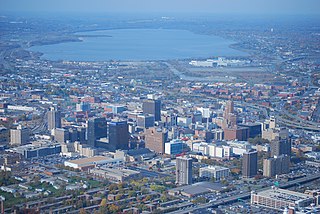
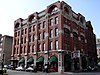
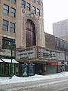
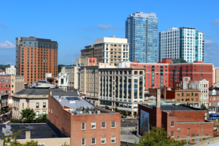
Downtown Syracuse is the economic center of Syracuse, New York, and Central New York, employing over 30,000 people, and housing over 4,300.

The Greater Richmond, Virginia area has many neighborhoods and districts.

<span class="mw-page-title-main">Westside, Syracuse</span>

Westside is a Syracuse, New York neighborhood, directly west of Downtown Syracuse. It corresponds to Onondaga County Census Tracts 21 and 22. It is made up of three parts, near West side, far west side and the West side

<span class="mw-page-title-main">Penn Quarter</span> Neighborhood of Washington, D.C., United States

Penn Quarter, often referred to as Old Downtown, is a historic neighborhood of Downtown Washington, D.C., located north of Pennsylvania Avenue, in Northwest D.C. Penn Quarter is roughly equivalent to the city's early downtown core near Pennsylvania Avenue and 7th Street NW, Penn Quarter is an entertainment and commercial hub, home to many museums, theaters, cinemas, restaurants, bars, art galleries and retail shops. Landmarks include the Capital One Arena, the National Portrait Gallery, and the Harman Center for the Arts, among others. The area is also home to a popular farmers market and several food, wine, art, and culture focused festivals.

<span class="mw-page-title-main">Downtown Stamford</span> United States historic place

Downtown Stamford, or Stamford Downtown, is the central business district of the city of Stamford, Connecticut, United States. It includes major retail establishments, a shopping mall, a university campus, the headquarters of major corporations and Fortune 500 companies, as well as other retail businesses, hotels, restaurants, offices, entertainment venues and high-rise apartment buildings.

<span class="mw-page-title-main">Inner Harbor, Syracuse</span>

The Inner Harbor is a former industrial quarter of Syracuse, New York, situated at the center of a larger district long colloquially known as Oil City, and since 1989 rebranded as the Lakefront. The waterfront zone was originally considered to be limited to just that area bounded by West Kirkpatrick, Solar, West Bear, and Van Rensselaer streets, but it has been gradually enlarged by the process of familiarity and promotion to include the opposite sides of some of those streets.

<span class="mw-page-title-main">Downtown (Washington, D.C.)</span> United States historic place

Downtown is the central business district of Washington, D.C., located in Northwest D.C. It is the fourth largest central business district in the United States. The "Traditional Downtown" has been defined as an area roughly between Union Station in the east and 16th Street NW in the west, and between the National Mall on the south and Massachusetts Avenue on the north, including Penn Quarter. However, nowadays, Downtown D.C. usually refers to a larger area, as the DC Office of Planning states:

…most residents, workers, and visitors think of Downtown in a broader sense — including areas as far north as Dupont Circle, as far west as Foggy Bottom, and as far east as Capitol Hill. Only about half of the central city workforce is located within the city’s traditional Downtown.

<span class="mw-page-title-main">Downtown Paterson</span> Commercial district in Passaic County, New Jersey, US

Downtown Paterson is the main commercial district of Paterson, Passaic County, in the U.S. state of New Jersey. The area is the oldest part of the city, along the banks of the Passaic River and its Great Falls. It is roughly bounded by Interstate 80, Garret Mountain Reservation, Route 19, Oliver Street, and Spruce Street on the south; the Passaic River, West Broadway, Cliff Street, North 3rd Street, Haledon Avenue, and the borough of Prospect Park on the west; and the Passaic River also to the north.

<span class="mw-page-title-main">Norwichtown</span> United States historic place

Norwichtown is a historic neighborhood in the city of Norwich, Connecticut. It is generally the area immediately north of the Yantic River between I-395 and Route 169.

<span class="mw-page-title-main">Hinton Historic District</span> Historic district in West Virginia, United States

The Hinton Historic District is a national historic district located at Hinton, Summers County, West Virginia. The original Hinton Historic District is bordered roughly by the Chesapeake and Ohio Railroad line, James Street, 5th Avenue, and Roundhouse. The boundary increase extended the district to include Mill Street. It was listed on the National Register of Historic Places in 1984 and revised in 2005.

<span class="mw-page-title-main">NoMad, Manhattan</span> Neighborhood in Manhattan, New York City

NoMad, also known as Madison Square North, is a neighborhood centered on the Madison Square North Historic District in the borough of Manhattan in New York City.

<span class="mw-page-title-main">Clinton Downtown Historic District (Clinton, Michigan)</span> Historic district in Michigan, United States

The Clinton Downtown Historic District is a historic district located in the village of Clinton in Clinton Township in the northernmost portion of Lenawee County, Michigan. It consists of most of the 100 block of U.S. Route 12, known locally as West Michigan Avenue, plus Memorial Park at 200 West Michigan. The district was added to the National Register of Historic Places on April 27, 2010.

<span class="mw-page-title-main">University Hill, Syracuse</span> Neighborhood and business district in Syracuse, New York

University Hill is a neighborhood and business district in Syracuse, New York, located east and southeast of Downtown Syracuse, on one of the larger hills in Syracuse. The neighborhood is bounded on the west by Almond Street and Interstate 81. It continues east to Ostrom Avenue and Thornden Park, where it borders the Westcott and University neighborhoods. Interstate 690 currently serves as the neighborhood's northern boundary.

<span class="mw-page-title-main">Onondaga Creekwalk</span>

The Onondaga Creekwalk is a mostly paved, partly bricked, multi-use trail running 4.8 miles (7.7 km) in Syracuse, New York, which has so far seen more than three decades of planning, construction, and delays, starting in 1988. The trail is designed for bicyclists, skaters, and pedestrians to approximately parallel any desired portion of Onondaga Creek's run connecting Kirk Park on Syracuse's South Side, downstream through downtown at Armory Square, and then on to Onondaga Lake at the creek's ultimate mouth.

The Jefferson Clinton Hotel, formerly known as the Dome Hotel, in the Armory Square area of Syracuse, New York, is a hotel dating from 1927.

<span class="mw-page-title-main">Syracuse station (Delaware, Lackawanna and Western Railroad)</span>

Syracuse station was the Delaware, Lackawanna and Western's railroad station in Syracuse, New York. It was housed in different buildings in succession. It hosted trains going north to Oswego, New York on the Lake Ontario coast by way of the DLW's acquisition, the former Oswego and Syracuse Railroad; and it also hosted trains going south to Binghamton on the route of the former Syracuse and Binghamton Railroad, and further to Hoboken, New Jersey.

References

  1. "National Register Information System". National Register of Historic Places . National Park Service. April 15, 2008.
  2. "Onondaga Creekwalk opens, connecting Armory Square and Onondaga Lake". October 25, 2011.
  3. Harwood, John F. (July 25, 1984). National Register of Historic Places Inventory/Nomination: Armory Square Historic District. File Unit: National Register of Historic Places and National Historic Landmarks Program Records: New York, 1964 - 2013. Retrieved April 21, 2021. Includes accompanying 36 photos from 1983.