Artemus, Kentucky

Last updated

Artemus, Kentucky
USA Kentucky location map.svg
Red pog.svg
Artemus
Usa edcp location map.svg
Red pog.svg
Artemus
Coordinates: 36°50′06″N83°50′29″W / 36.83500°N 83.84139°W / 36.83500; -83.84139
Country United States
State Kentucky
County Knox
Area
[1]
  Total1.35 sq mi (3.51 km2)
  Land1.35 sq mi (3.50 km2)
  Water0.01 sq mi (0.01 km2)
Elevation
[2]
1,079 ft (329 m)
Population
 (2020)
  Total453
  Density335.56/sq mi (129.55/km2)
Time zone UTC-5 (Eastern (EST))
  Summer (DST) UTC-4 (EDT)
ZIP code
40903
Area code 606
FIPS code 21-02188
GNIS feature ID2629567 [2]

Artemus is an unincorporated community and census-designated place in Knox County, Kentucky, United States. As of the 2010 United States Census the population was 590. [3]

Contents

Geography

The community is in central Knox County, 4 miles (6 km) southeast of Barbourville, the county seat. It sits on the north side of the Cumberland River. Kentucky Route 225 passes through the center of town, leading northwest to Barbourville and south 13 miles (21 km) to Kentucky Route 92 in Bell County.

According to the U.S. Census Bureau, the Artemus CDP has a total area of 1.4 square miles (3.5 km2), of which 0.004 square miles (0.01 km2), or 0.36%, are water. [3]

Climate

The climate in this area is characterized by hot, humid summers and generally mild to cool winters. According to the Köppen Climate Classification system, Artemus has a humid subtropical climate, abbreviated "Cfa" on climate maps. [4]

Demographics

Historical population
CensusPop.Note
2020 453
U.S. Decennial Census [5]

As of the 2010 census, there were 590 people, 233 households, and 163 families residing in the CDP. There were 282 housing units, of which 49, or 17.4%, were vacant. The racial makeup of the CDP was 96.9% white, 0.8% African American, 0.2% Native American, 0.2% Asian, 1.2% some other race, and 0.7% from two or more races. 1.5% of the population were Hispanic or Latino of any race. [6]

Of the 233 households in the CDP, 34.8% had children under the age of 18 living with them, 46.8% were headed by married couples living together, 16.7% had a female householder with no husband present, and 30.0% were non-families. 28.3% of all households were made up of individuals, and 12.4% were someone living alone who was 65 years of age or older. The average household size was 2.53, and the average family size was 3.10. [6]

24.4% of residents in the CDP were under the age of 18, 10.9% were from age 18 to 24, 23.6% were from 25 to 44, 24.6% were from 45 to 64, and 16.4% were 65 years of age or older. The median age was 38.8 years. For every 100 females, there were 96.0 males. For every 100 females age 18 and over, there were 90.6 males. [6]

For the period 2013–17, the estimated median annual income for a household was $55,057, and the median income for a family was $55,922. The per capita income for the CDP was $20,829. [7]

Related Research Articles

<span class="mw-page-title-main">Burlington, Kentucky</span> Census-designated place in Boone County, Kentucky, United States

Burlington is a census-designated place (CDP) in and the county seat of Boone County, Kentucky, United States. The population was 17,318 at the 2020 census.

<span class="mw-page-title-main">Ghent, Kentucky</span> City in Kentucky, United States

Ghent is a home rule-class city along the south bank of the Ohio River in Carroll County, Kentucky, in the United States. The population was 323 at the 2010 census.

Fort Campbell North is a census-designated place (CDP) in Christian County, Kentucky, United States. It contains most of the housing for the Fort Campbell Army base within the Kentucky portion of the base. The population was 13,685 at the 2010 census, down from 14,338 in 2000.

<span class="mw-page-title-main">Barbourville, Kentucky</span> City in Kentucky, United States

Barbourville is a home rule-class city in Knox County, Kentucky, in the United States. The population was 3,165 at the 2010 census, down from 3,589 at the 2000 census. It is the county seat of Knox County. The city was formally established by the state assembly in 1812. It was incorporated in 1854 and then reincorporated in 1856.

<span class="mw-page-title-main">Stearns, Kentucky</span> Census-designated place in Kentucky, United States

Stearns is an unincorporated community and census-designated place (CDP) in McCreary County, Kentucky, United States. The population was 1,365 at the 2020 census. It was founded by Justus Smith Stearns.

Lake Arrowhead is a census-designated place (CDP) in the towns of Waterboro and Limerick in York County, Maine, United States. The population was 3,071 at the 2010 census. The CDP corresponds to the area covered by the Lake Arrowhead Community, a large subdivision begun in the 1960s which surrounds Lake Arrowhead, an artificial lake on the Little Ossipee River. The community is part of the Portland–South Portland–Biddeford, Maine Metropolitan Statistical Area.

<span class="mw-page-title-main">Springvale, Maine</span> Place in Maine, United States

Springvale is a village and former census-designated place in the city of Sanford in York County, Maine, United States. The population was 3,292 at the 2010 census. It is part of the Portland–South Portland–Biddeford, Maine metropolitan statistical area. The CDP was abolished when the town of Sanford reincorporated as a city.

<span class="mw-page-title-main">Ferndale, Maryland</span> Census-designated place in Maryland, United States

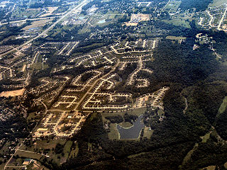
Ferndale is a census-designated place (CDP) in Anne Arundel County, Maryland, United States. At the 2010 census, the population was 16,746.

<span class="mw-page-title-main">Dunkirk, Maryland</span> Census-designated place in Maryland, United States

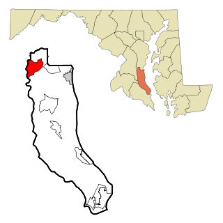
Dunkirk is a census-designated place (CDP) in Calvert County, Maryland, United States. The population was 2,521 at the 2010 census.

<span class="mw-page-title-main">Perryman, Maryland</span> Census-designated place in Maryland, United States

Perryman is an unincorporated community and census-designated place (CDP) in Harford County, Maryland, United States. The population was 2,342 at the 2010 census.

<span class="mw-page-title-main">Hubbell, Michigan</span> Census-designated place & unincorporated community in Michigan, United States

Hubbell is an unincorporated community and census-designated place (CDP) in Houghton County in the U.S. state of Michigan. As of the 2010 census, the CDP population was 946, down from 1,105 at the 2000 census. The community is partially within Torch Lake Township and partially within Osceola Township.

<span class="mw-page-title-main">Aquebogue, New York</span> Hamlet and census-designated place in New York, United States

Aquebogue is a census-designated place (CDP) roughly corresponding to the hamlet by the same name in the Town of Riverhead in Suffolk County, on Long Island, in New York, United States. The CDP's population was 2,438 at the 2010 census.

<span class="mw-page-title-main">Normanna, Texas</span> Census-designated place in Texas, United States

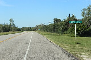
Normanna is a census-designated place in Bee County, Texas, United States. The population was 113 at the 2010 census.

<span class="mw-page-title-main">Olmito, Texas</span> Census-designated place in Texas, United States

Olmito is a census-designated place (CDP) in Cameron County, Texas, United States. Olmito is Spanish for "little elm". The population was 1,210 at the 2010 census. It is part of the Brownsville–Harlingen Metropolitan Statistical Area. Olmito is the self-described "mesquite capital of the world."

<span class="mw-page-title-main">Stonewall, Texas</span> Census-designated place in Texas, United States

Stonewall is an unincorporated community and census-designated place (CDP) in Gillespie County, Texas, United States. The population was 525 at the 2010 census. It was named for Confederate General Thomas J. (Stonewall) Jackson, by Israel P. Nunez who established a stage station near the site in 1870.

<span class="mw-page-title-main">Jolivue, Virginia</span> Census-designated place in Virginia, United States

Jolivue is a census-designated place (CDP) in Augusta County, Virginia, United States. The population was 1,129 at the 2010 census. It is part of the Staunton–Waynesboro Micropolitan Statistical Area.

<span class="mw-page-title-main">Rushmere, Virginia</span> Census-designated place in Virginia, United States

Rushmere is a census-designated place (CDP) in Isle of Wight County, Virginia, United States. The population was 1,018 at the 2010 census.

<span class="mw-page-title-main">North Corbin, Kentucky</span> Census-designated place in Kentucky, United States

North Corbin is a census-designated place (CDP) in Laurel and Knox counties in the U.S. state of Kentucky. The population was 1,727 at the 2020 census down from 1,773 at the 2010 census. The census bureau also lists the Laurel County portion of North Corbin as a CCD with a population of 10,729.

<span class="mw-page-title-main">Horseshoe Bay, Texas</span> City in Texas, United States

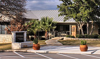
Horseshoe Bay is a city in Llano and Burnet counties in the U.S. state of Texas.

<span class="mw-page-title-main">Knox County, Kentucky</span> County in Kentucky, United States

Knox County is a county located in Appalachia near the southeastern corner of the U.S. state of Kentucky. As of the 2020 census, the population was 30,193. Its county seat is Barbourville. The county is named for General Henry Knox. It is one of the few coal-producing counties in Kentucky that has not suffered massive population loss. Knox County is included in the London, KY Micropolitan Statistical Area.

References

  1. "2020 U.S. Gazetteer Files". United States Census Bureau. Retrieved March 18, 2022.
  2. 1 2 "Artemus Census Designated Place". Geographic Names Information System . United States Geological Survey, United States Department of the Interior . Retrieved September 30, 2023.
  3. 1 2 "Geographic Identifiers: 2010 Demographic Profile Data (G001): Artemus CDP, Kentucky". American Factfinder. U.S. Census Bureau. Retrieved March 7, 2019.[ dead link ]
  4. Climate Summary for Artemus, Kentucky
  5. "Census of Population and Housing". Census.gov. Retrieved June 4, 2016.
  6. 1 2 3 "Profile of General Population and Housing Characteristics: 2010 Census Summary File 1 (DP-1): Artemus CDP, Kentucky". U.S. Census Bureau, American Factfinder. Archived from the original on February 13, 2020. Retrieved March 7, 2019.
  7. "Selected Economic Characteristics: 2013-2017 American Community Survey 5-Year Estimates (DP03): Artemus CDP, Kentucky". U.S. Census Bureau, American Factfinder. Archived from the original on February 13, 2020. Retrieved March 7, 2019.