Ashburton District

Last updated

Ashburton District
Ashburton Territorial Authority.png
Country New Zealand
Region Canterbury
Wards
  • Western
  • Eastern
  • Ashburton
Formed1989
Seat Ashburton
Government
  Mayor Neil Brown
   Territorial authority Ashburton District Council
Area
[1]
  Total6,181.59 km2 (2,386.73 sq mi)
Population
 (June 2022) [2]
  Total36,300
  Density5.9/km2 (15/sq mi)
Time zone UTC+12 (NZST)
  Summer (DST) UTC+13 (NZDT)
Postcode(s)
Website Ashburton District Council

Ashburton District is a territorial authority district in the Canterbury Region of the South Island of New Zealand. It encompasses the town of Ashburton, a number of small towns and settlements and the surrounding rural area, roughly coterminous with Mid Canterbury. The district had a population of 36,300 as of June 2022. [2]

Contents

Geography

Ashburton District extends from the Pacific Ocean to the Southern Alps, and from the Rangitata River to the Rakaia River, including the towns of Methven, Mount Somers, and Rakaia. The Hakatere Conservation Park covers a large area of the lower mountains, including Mount Hutt skifield, popular tramping area Mount Somers / Te Kiekie and the Ashburton Lakes.

Demographics

Ashburton District covers 6,181.69 km2 (2,386.76 sq mi) [1] and had an estimated population of 36,300 as of June 2022, [2] with a population density of 5.9 people per km2.

Historical population
YearPop.±% p.a.
200627,372    
201331,041+1.81%
201833,423+1.49%
Source: [3]

Ashburton District had a population of 33,423 at the 2018 New Zealand census, an increase of 2,382 people (7.7%) since the 2013 census, and an increase of 6,051 people (22.1%) since the 2006 census. There were 12,996 households. There were 17,016 males and 16,407 females, giving a sex ratio of 1.04 males per female. The median age was 39.1 years (compared with 37.4 years nationally), with 6,810 people (20.4%) aged under 15 years, 5,937 (17.8%) aged 15 to 29, 14,697 (44.0%) aged 30 to 64, and 5,982 (17.9%) aged 65 or older.

Ethnicities were 83.8% European/Pākehā, 8.2% Māori, 5.1% Pacific peoples, 7.4% Asian, and 2.3% other ethnicities. People may identify with more than one ethnicity.

The percentage of people born overseas was 18.6, compared with 27.1% nationally.

Although some people objected to giving their religion, 44.7% had no religion, 45.4% were Christian, 0.8% were Hindu, 0.2% were Muslim, 0.4% were Buddhist and 1.8% had other religions.

Of those at least 15 years old, 3,477 (13.1%) people had a bachelor or higher degree, and 6,243 (23.5%) people had no formal qualifications. The median income was $35,900, compared with $31,800 nationally. 4,071 people (15.3%) earned over $70,000 compared to 17.2% nationally. The employment status of those at least 15 was that 14,211 (53.4%) people were employed full-time, 4,281 (16.1%) were part-time, and 633 (2.4%) were unemployed. [3]

Individual wards (2018 boundaries)
NameArea (km2)PopulationDensity (per km2)HouseholdsMedian ageMedian income
Western Ward4,745.235,5321.172,16635.2 years$41,300
Eastern Ward1,385.889,0486.533,34536.6 years$41,100
Ashburton Ward50.5818,846372.607,48542.0 years$31,700
New Zealand37.4 years$31,800

Government

Ashburton District Council administers the district. The council consists of a mayor and nine councillors. The councillors are elected from three wards: five from the Ashburton ward, and two each from the Eastern and Western wards.

Related Research Articles

<span class="mw-page-title-main">Waipa District</span> Place in Waikato, New Zealand

Waipa District is a municipality in the Waikato region of New Zealand that is administered by the Waipa District Council. Its most populous town is Cambridge. The seat of the council is at the second most populous town, Te Awamutu. The district is south and south-east of the city of Hamilton. It has five wards: Te Awamutu, Cambridge, Pirongia, Maungatautari and Kakepuku.

<span class="mw-page-title-main">Western Bay of Plenty District</span> Territorial authority in Bay of Plenty, New Zealand

Western Bay of Plenty District is a territorial authority within the Bay of Plenty Region of New Zealand. The district envelops Tauranga City by land, and includes Matakana Island, at the entrance to Tauranga Harbour.

<span class="mw-page-title-main">Central Hawke's Bay District</span> Territorial authority in Hawkes Bay, New Zealand

Central Hawke's Bay District is part of the Hawke's Bay Region in the North Island of New Zealand. Formed in 1989, it has an area of 3,333 square kilometres with a population of 15,950. It had a population of 12,717 people as of the 2013 census. This is a decrease of 237 people, or 1.8 percent, since the 2006 census. It covers the area from Pukehou in the north to Takapau in the south, and from the western Ruahine Range to the Pacific coast in the east.

<span class="mw-page-title-main">Rakaia</span> Town in Canterbury, New Zealand

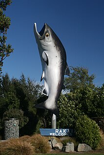
Rakaia is a town seated close to the southern banks of the Rakaia River on the Canterbury Plains in New Zealand's South Island, approximately 57 km south of Christchurch on State Highway 1 and the Main South Line. Immediately north of the township are New Zealand's longest road bridge and longest rail bridge, both of which cross the wide shingle beds of the braided river at this point. Both bridges are approximately 1750 metres in length.

<span class="mw-page-title-main">Selwyn District</span> Territorial authority in Canterbury, New Zealand

Selwyn District is a predominantly rural area in central Canterbury, on the east coast of New Zealand's South Island. It is named after the Selwyn River / Waikirikiri, which is in turn named after Bishop George Selwyn, the first Anglican bishop of New Zealand who, in 1843 and 1844, travelled the length of the country by horse, foot, boat and canoe, leaving in his wake a sprinkling of locations that now bear his name.

<span class="mw-page-title-main">Buller District</span> Territorial authority in West Coast Region, New Zealand

Buller District is one of 53 districts of New Zealand, and is within the West Coast Region. It covers Westport, Karamea, Reefton and Inangahua Junction.

<span class="mw-page-title-main">Grey District</span> Territorial authority in West Coast Regional Council, New Zealand

Grey District in the West Coast Region of New Zealand is a municipality that covers Greymouth, Runanga, Blackball, Cobden and settlements along the Grey River. It has a land area of 3,474.44 square kilometres (1,341.49 sq mi). The seat of the Grey District Council, the local government authority that administers the district, is at Greymouth, where 58.6% of the district's population live.

<span class="mw-page-title-main">South Taranaki District</span> Territorial authority in Taranaki, New Zealand

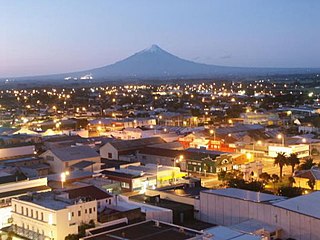
South Taranaki is a territorial authority on the west coast of New Zealand's North Island that contains the towns of Hāwera, Manaia, Ōpunake, Patea, Eltham, and Waverley. The District has a land area of 3,575.46 km2 and a population of 29,600. It is part of the greater Taranaki Region.

<span class="mw-page-title-main">Ruapehu District</span> Territorial authority of New Zealand in North Island

Ruapehu District is a territorial authority in the centre of New Zealand's North Island.

<span class="mw-page-title-main">Hurunui District</span> Territorial authority in Canterbury, New Zealand

Hurunui District is a territorial local government district within the Canterbury Region on the east coast of New Zealand's South Island, north of Christchurch. It stretches from the east coast to the Main Divide. Its land area is 8,640.96 square kilometres (3,336.29 sq mi).

<span class="mw-page-title-main">Taupō District</span> District in New Zealand

Taupō District is a territorial authority district in New Zealand. It covers 6,333 km² of land, and a further 610 km² of lake area, including Lake Taupō, New Zealand's largest lake, and Lake Rotoaira. The district stretches from the small town of Mangakino in the northwest to the Tongariro National Park in the south, and east into the Kaingaroa Forest. The district's population is largely located in the two main centres, Taupō and Tūrangi.

<span class="mw-page-title-main">Whangarei District</span> Territorial authority in Northland, New Zealand

Whangarei District is a territorial authority district in the Northland Region of New Zealand that is governed by the Whangarei District Council. The district is made up in area largely by rural land, and includes a fifth of the Northland Region. It extends southwards to the southern end of Bream Bay, northwards to Whangaruru and almost to the Bay of Islands, and westwards up the Mangakahia River valley past Pakotai and almost to Waipoua Forest. It includes the Hen and Chicken Islands and the Poor Knights Islands.

<span class="mw-page-title-main">Waitākere ward</span> Ward of Auckland in New Zealand

Waitākere Ward is a district of Auckland Council in New Zealand. It consists of the part of the old Waitakere City lying west of a line from Te Atatū Peninsula to Titirangi.

<span class="mw-page-title-main">Ōrākei ward</span> Ward of Auckland in New Zealand

Ōrākei Ward is one of thirteen wards of Auckland Council in Auckland, New Zealand. It encompasses the neighbourhoods of Saint Heliers, Glendowie, Kohimarama, Mission Bay, Saint Johns and Meadowbank. It elects one councillor to represent the ward on the council. The councillor has oversight over the Orakei Local Board. The current councillor is Desley Simpson.

<span class="mw-page-title-main">Franklin ward</span> Ward of Auckland in New Zealand

The Franklin Ward is the southernmost ward on the Auckland Council. The Franklin ward has one local board, also called Franklin; the Franklin Local Board has three subdivisions - Wairoa, Pukekohe and Waiuku. Franklin is currently represented by Andy Baker.

<span class="mw-page-title-main">North Shore ward</span> Ward of Auckland in New Zealand

North Shore Ward is an Auckland Council ward that elects two councillors and covers the Devonport-Takapuna and Kaipātiki Local Boards. The two councillors are currently Richard Hills and Chris Darby.

<span class="mw-page-title-main">Albany ward (local government)</span> Ward of Auckland in New Zealand

Albany Ward is an Auckland Council ward which elects two councillors and covers the Hibiscus and Bays and Upper Harbour Local Boards. The two councillors are currently John Watson and Wayne Walker.

<span class="mw-page-title-main">Manukau ward</span> Ward of Auckland in New Zealand

Manukau Ward is an Auckland Council ward that elects two councillors and covers the Māngere-Ōtāhuhu and Ōtara-Papatoetoe Local Boards. The two councillors are currently Alf Filipaina and Lotu Fuli.

<span class="mw-page-title-main">Waitematā and Gulf ward</span> Ward of Auckland in New Zealand

Waitematā and Gulf Ward is an Auckland Council ward which elects one councillor and covers the Great Barrier, Waiheke, and Waitematā Local Boards. The current councillor is Mike Lee.

<span class="mw-page-title-main">Whau ward</span> Ward of Auckland in New Zealand

Whau Ward is an Auckland Council ward which elects one councillor and covers the Whau Local Board. The current councillor is Kerrin Leoni.

References

  1. 1 2 "ArcGIS Web Application". statsnz.maps.arcgis.com. Retrieved 13 March 2022.
  2. 1 2 3 "Subnational population estimates (RC, SA2), by age and sex, at 30 June 1996-2022 (2022 boundaries)". Statistics New Zealand . Retrieved 25 October 2022. (regional councils); "Subnational population estimates (TA, SA2), by age and sex, at 30 June 1996-2022 (2022 boundaries)". Statistics New Zealand . Retrieved 25 October 2022. (territorial authorities); "Subnational population estimates (urban rural), by age and sex, at 30 June 1996-2022 (2022 boundaries)". Statistics New Zealand . Retrieved 25 October 2022. (urban areas)
  3. 1 2 "Statistical area 1 dataset for 2018 Census". Statistics New Zealand. March 2020. Ashburton District (063). 2018 Census place summary: Ashburton District

Coordinates: 43°32′44″S171°14′21″E / 43.5456°S 171.2393°E / -43.5456; 171.2393