Asherton, Texas

Last updated

Asherton, Texas
Bel-Asher House, Asherton, TX IMG 4212.JPG
Bel-Asher House in Asherton
TXMap-doton-Asherton.PNG
Location of Asherton, Texas
Dimmit County Asherton.svg
Coordinates: 28°26′50″N99°45′41″W / 28.44722°N 99.76139°W / 28.44722; -99.76139
Country United States
State Texas
County Dimmit
Area
[1]
  Total0.82 sq mi (2.11 km2)
  Land0.82 sq mi (2.11 km2)
  Water0.00 sq mi (0.00 km2)
Elevation
[2]
532 ft (162 m)
Population
 (2010)
  Total1,084
  Estimate 
(2019) [3]
1,039
  Density1,271.73/sq mi (491.31/km2)
Time zone UTC-6 (Central (CST))
  Summer (DST) UTC-5 (CDT)
ZIP code
78827
Area code 830
FIPS code 48-04300 [4]
GNIS feature ID2409739 [2]

Asherton is a city in Dimmit County, Texas, United States. [2] The population was 1,084 at the 2010 census, [5] down from 1,342 at the 2000 census. The estimated population in 2018 was 1,064. U.S. Highway 83 passes through Asherton.

Contents

Geography

Asherton is located at the center of Dimmit County at 28°26′50″N99°45′41″W / 28.44722°N 99.76139°W / 28.44722; -99.76139 (28.447159, –99.761504). [6] It is on the east side of El Moro Creek, a northeastward-flowing tributary of the Nueces River. U.S. Highway 83 leads northwest 8 miles (13 km) to Carrizo Springs, the county seat, and south 72 miles (116 km) to Laredo.

According to the United States Census Bureau, Asherton has a total area of 0.81 square miles (2.1 km2), all land. [5]

Demographics

Historical population
CensusPop.Note
1930 1,858
1940 1,538−17.2%
1950 2,42557.7%
1960 1,890−22.1%
1970 1,645−13.0%
1980 1,574−4.3%
1990 1,6082.2%
2000 1,342−16.5%
2010 1,084−19.2%
2019 (est.)1,039 [3] −4.2%
U.S. Decennial Census [7]

2020 census

Asherton racial composition [8]
(NH = Non-Hispanic) [lower-alpha 1]
RaceNumberPercentage
White (NH)212.91%
Black or African American (NH)10.14%
Pacific Islander (NH)20.28%
Mixed/Multi-Racial (NH)30.42%
Hispanic or Latino 69596.26%
Total722

As of the 2020 United States census, there were 722 people, 353 households, and 199 families residing in the city.

2000 census

As of the census [4] of 2000, there were 1,342 people, 428 households, and 341 families residing in the city. The population density was 1,609.6 inhabitants per square mile (621.5/km2). There were 535 housing units at an average density of 641.7 per square mile (247.8/km2). The racial makeup of the city was 75.56% White, 0.15% African American, 0.15% Native American, 0.07% Asian, 21.39% from other races, and 2.68% from two or more races. Hispanic or Latino of any race were 94.78% of the population.

There were 428 households, out of which 42.8% had children under the age of 18 living with them, 56.8% were married couples living together, 18.5% had a female householder with no husband present, and 20.3% were non-families. 18.9% of all households were made up of individuals, and 11.2% had someone living alone who was 65 years of age or older. The average household size was 3.13 and the average family size was 3.62.

In the city, the population was spread out, with 35.2% under the age of 18, 7.6% from 18 to 24, 23.6% from 25 to 44, 20.8% from 45 to 64, and 12.8% who were 65 years of age or older. The median age was 31 years. For every 100 females, there were 87.7 males. For every 100 females age 18 and over, there were 83.2 males.

The median income for a household in the city was $20,417, and the median income for a family was $24,107. Males had a median income of $23,281 versus $17,500 for females. The per capita income for the city was $7,746. About 29.9% of families and 35.8% of the population were below the poverty line, including 40.8% of those under age 18 and 41.8% of those age 65 or over.

Asherton Elementary School; older students attend high school in Carrizo Springs. Asherton Elementary School, Asherton, TX IMG 4196.JPG
Asherton Elementary School; older students attend high school in Carrizo Springs.

Education

Public education in Asherton is provided by the Carrizo Springs Consolidated Independent School District. [10]

Schools that serve Asherton include:

Prior to July 1, 1999, [11] the Asherton Independent School District served Asherton. AISD was forced to close because of concerns about taxation. [12]

Related Research Articles

<span class="mw-page-title-main">Webb County, Texas</span> County in Texas, United States

Webb County is a county located in the U.S. state of Texas. As of the 2020 census, its population was 267,114. Its county seat is Laredo. The county was named after James Webb (1792–1856), who served as secretary of the treasury, secretary of state, and attorney general of the Republic of Texas, and later judge of the United States District Court following the admission of Texas to statehood. By area, Webb County is the largest county in South Texas and the sixth-largest in the state. Webb County comprises the Laredo metropolitan area. Webb County is the only county in the United States to border three foreign states or provinces, sharing borders with Coahuila, Nuevo Leon, and Tamaulipas.

<span class="mw-page-title-main">Howard County, Texas</span> County in Texas, United States

Howard County is a county located in the U.S. state of Texas. At the 2020 census, its population was 34,860. Its county seat is Big Spring. The county was created in 1876 and organized in 1882. It is named for Volney E. Howard, a U.S. Congressman from Texas.

<span class="mw-page-title-main">Hopkins County, Texas</span> County in Texas, United States

Hopkins County is a county located in the U.S. state of Texas. As of the 2020 census, its population was 36,787. Its county seat is Sulphur Springs. Hopkins County is named for the family of David Hopkins, an early settler in the area. Hopkins County comprises the Sulphur Springs, TX Micropolitan Statistical Area. Hopkins County was once known as the Dairy Capital of Texas. Although dairy farms declined in the area in the late 1990s there are still a number of these located there. The Southwest Dairy Museum is located in Sulphur Springs.

<span class="mw-page-title-main">Haskell County, Texas</span> County in Texas, United States

Haskell County is a county located in the U.S. state of Texas. As of the 2020 census, its population was 5,416. The county seat is Haskell. The county was created in 1858 and later organized in 1885. It is named for Charles Ready Haskell, who was killed in the Goliad massacre.

<span class="mw-page-title-main">Frio County, Texas</span> County in Texas, United States

Frio County is a county located in the U.S. state of Texas. As of the 2020 census, its population was 18,385. The county seat is Pearsall. The county was created in 1858 and later organized in 1871. Frio is named for the Frio River, whose name is Spanish for "cold".

<span class="mw-page-title-main">Dimmit County, Texas</span> County in Texas, United States

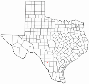
Dimmit County is a county located in the U.S. state of Texas. As of the 2020 census, its population was 8,615. The county seat is Carrizo Springs. The county was founded in 1858 and later organized in 1880. It is named after Philip Dimmitt, a major figure in the Texas Revolution. The spelling of the county name and the individual's name differ because of a spelling error in the bill creating the county name.

<span class="mw-page-title-main">Cooke County, Texas</span> County in Texas, United States

Cooke County is a county in the U.S. state of Texas. At the 2020 census, its population was 41,668. The county seat is Gainesville. The county was founded in 1848 and organized the next year. It is named for William Gordon Cooke, a soldier during the Texas Revolution. It is a part of the Texoma region.

<span class="mw-page-title-main">Belleview, Florida</span> City in Florida, United States

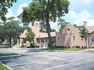
Belleview is a city in Marion County, Florida, United States. The population was 5,413 at the 2020 census, up from 4,492 in 2010. It is part of the Ocala Metropolitan Statistical Area. The city's name comes from the French words belle and vue, meaning "beautiful view". "City with Small Town Charm" is the city's motto.

Pistakee Highlands is a census-designated place (CDP) in McHenry County, Illinois, United States. It consists primarily of an unincorporated area of McHenry County adjoining Pistakee Bay, within the McHenry post office, and is located just northeast of Johnsburg. Per the 2020 census, the population was 3,237.

<span class="mw-page-title-main">Strandquist, Minnesota</span> City in Minnesota, United States

Strandquist is a city in Lincoln Township of Marshall County, Minnesota, United States. The population was 70 at the 2020 census.

<span class="mw-page-title-main">Dimmitt, Texas</span> City in Texas, United States

Dimmitt is a city and county seat in Castro County, Texas, United States. Its population was 4,393 at the 2010 census.

<span class="mw-page-title-main">Big Wells, Texas</span> City in Texas, United States

Big Wells is a city in Dimmit County, Texas, United States. The population was 697 at the 2010 census, with an estimated population of 712 in 2018.

<span class="mw-page-title-main">Brundage, Texas</span> Census-designated place in Texas, United States

Brundage is an unincorporated community and census-designated place (CDP) in Dimmit County, Texas, United States. The population was 27 at the 2010 census.

<span class="mw-page-title-main">Carrizo Hill, Texas</span> CDP in Texas, United States

Carrizo Hill is a census-designated place (CDP) in Dimmit County, in the U.S. state of Texas, United States. The population was 582 at the 2010 census.

<span class="mw-page-title-main">Carrizo Springs, Texas</span> City in Texas, United States

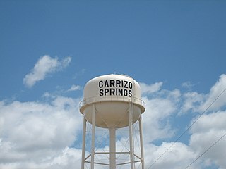
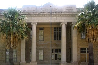
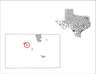
Carrizo Springs is the largest city in and the county seat of Dimmit County, Texas, United States. The population was 5,368 at the 2010 census..

<span class="mw-page-title-main">Catarina, Texas</span> CDP in Texas, United States

Catarina is a census-designated place (CDP) in Dimmit County, Texas, United States. The population was 118 at the 2010 census. The community has no U.S. Post Office.

<span class="mw-page-title-main">Dilley, Texas</span> City in Texas, United States

Dilley is a city in Frio County, Texas, United States. The population was 3,894 at the 2010 census. It is located off Interstate 35, south of the county seat in Pearsall.

<span class="mw-page-title-main">Merkel, Texas</span> Town in Texas, United States

Merkel is a city in Taylor County, Texas, United States. Its population was 2,590 at the 2010 census. It is part of the Abilene metropolitan area.

<span class="mw-page-title-main">San Diego, Texas</span> City in Texas, United States

San Diego is a city in Duval and Jim Wells counties, Texas, United States. The population was 3,748 at the 2020 census and 4,488 at the 2010 census. It is located primarily in Duval County, of which it is the county seat.

<span class="mw-page-title-main">Tatum, Texas</span> City in Texas

Tatum is a city in Panola and Rusk Counties in the U.S. state of Texas. Its population was 1,342 at the 2020 census.

References

  1. "2019 U.S. Gazetteer Files". United States Census Bureau. Retrieved August 7, 2020.
  2. 1 2 3 U.S. Geological Survey Geographic Names Information System: Asherton, Texas
  3. 1 2 "Population and Housing Unit Estimates". United States Census Bureau. May 24, 2020. Retrieved May 27, 2020.
  4. 1 2 "U.S. Census website". United States Census Bureau . Retrieved January 31, 2008.
  5. 1 2 "Geographic Identifiers: 2010 Demographic Profile Data (G001): Asherton city, Texas". American Factfinder. U.S. Census Bureau. Archived from the original on February 13, 2020. Retrieved January 8, 2016.
  6. "US Gazetteer files: 2010, 2000, and 1990". United States Census Bureau. February 12, 2011. Retrieved April 23, 2011.
  7. "Census of Population and Housing". Census.gov. Retrieved June 4, 2015.
  8. "Explore Census Data". data.census.gov. Retrieved May 20, 2022.
  9. "About the Hispanic Population and its Origin". www.census.gov. Retrieved May 18, 2022.
  10. "2020 CENSUS - SCHOOL DISTRICT REFERENCE MAP: Dimmit County, TX" (PDF). U.S. Census Bureau . Retrieved June 30, 2022. - Text list - All of Dimmit County is in Carrizo Springs ISD.
  11. "CONSOLIDATIONS, ANNEXATIONS AND NAME CHANGES FOR TEXAS PUBLIC SCHOOLS" (PDF). Texas Education Agency. September 10, 2018. Retrieved October 30, 2019.
  12. "A Case Study of Carrizo Springs Consolidated Independent School District and its role as a partner in the NSF-supported Texas Rural Systemic Initiative". Prepared by Kenneth H. McKinley. The Evaluation Center, Western Michigan University. Archived from the original on July 13, 2007. Retrieved May 11, 2009.
  1. Note: the US Census treats Hispanic/Latino as an ethnic category. This table excludes Latinos from the racial categories and assigns them to a separate category. Hispanics/Latinos can be of any race. [9]