Related Research Articles

The Chicago "L" is the rapid transit system serving the city of Chicago and some of its surrounding suburbs in the U.S. state of Illinois. Operated by the Chicago Transit Authority (CTA), it is the fourth-largest rapid transit system in the United States in terms of total route length, at 102.8 miles (165.4 km) long as of 2014, and the third busiest rapid transit system in the United States, after the Washington Metro and New York City Subway. In 2016, the "L" had 1,492 rail cars, eight different routes, and 145 train stations. In 2022, the system had 103,524,900 rides, or about 322,200 per weekday in the first quarter of 2023.
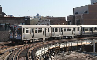
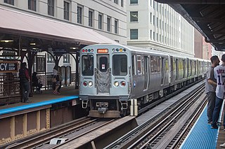
The Red Line is a rapid transit line in Chicago, run by the Chicago Transit Authority (CTA) as part of the Chicago "L" system. It is the busiest line on the "L" system, with an average of 73,273 passengers boarding each weekday in 2021. The route is 26 miles (42 km) long with a total of 33 stations. It runs elevated from the Howard station in the Rogers Park neighborhood on the North Side, through a subway on the Near North Side, Downtown, and the South Loop, and then through the Dan Ryan Expressway median to 95th/Dan Ryan in the Roseland neighborhood on the South Side.
The Orange Line is a rapid transit line in Chicago, Illinois, operated by the Chicago Transit Authority as part of the Chicago "L" system. It is approximately 13 miles (21 km) long and runs on elevated and at grade tracks and serves the Southwest Side, running from the Loop to Midway International Airport. As of 2021, an average of 11,006 riders board Orange Line trains on weekdays.

The Silver Line is a system of bus routes in Boston and Chelsea, Massachusetts, operated by the Massachusetts Bay Transportation Authority (MBTA). It is operated as part of the MBTA bus system, but branded as bus rapid transit (BRT) as part of the MBTA subway system. Six routes are operated as part of two disconnected corridors. As of 2019, weekday ridership on the Silver Line was 39,000.
The Urban Ring was a proposed project of the Massachusetts Bay Transportation Authority and the Massachusetts Department of Transportation, to develop new public transportation routes that would provide improved circumferential connections among many existing transit lines that project radially from downtown Boston. The Urban Ring Corridor is located roughly one to two miles from downtown Boston, passing through the Massachusetts cities of Boston, Chelsea, Everett, Medford, Somerville, Cambridge, and Brookline. The project was expected to convert 41,500 car trips to transit trips daily.
The Chicago Central Area Transit Plan, generally referred to as the Chicago Central Area Transit Project (CCATP) in the 1970s, was an extensive study of the rapid transit system in downtown Chicago; the study had begun in 1965.

The Geary Bus Rapid Transit project added bus rapid transit features to San Francisco Municipal Railway bus lines along Geary Boulevard. The corridor serves routes 38, 38R, 38AX, 38BX which combined to serve 52,900 daily riders in 2019, the most of any corridor in the city. The project added transit-only lanes, painted red, along many sections of Geary between the Transbay Transit Center and 33rd Avenue. After the project’s completion, over 75% of Geary corridor now has transit lanes.

Van Ness Bus Rapid Transit is a bus rapid transit (BRT) corridor on Van Ness Avenue in San Francisco, California, United States. The 1.96-mile (3.15 km) line, which runs between Mission Street and Lombard Street, has dedicated center bus lanes and nine stations. It was built as part of the $346 million Van Ness Improvement Project, which also included utility replacement and pedestrian safety features. Van Ness Bus Rapid Transit is used by several San Francisco Municipal Railway (Muni) lines including the 49 Van Ness–Mission, as well as three Golden Gate Transit routes.
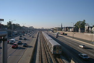
The Dan Ryan branch is a 9.4 mi (15.1 km) long section of the Chicago "L" system located on the South Side of Chicago, Illinois. It is operated by the Chicago Transit Authority, as part of its Red Line service and is normally through-routed downtown towards the North Side via the State Street subway. As of February 2013, the branch serves 45,355 passengers per weekday. As part of the CTA's busiest rapid transit line, it is operated 24 hours a day, 365 days a year. The branch serves the Chinatown, Armour Square, Fuller Park, Englewood, Greater Grand Crossing, Chatham and Roseland neighborhoods.

Bus rapid transit in New Jersey comprises limited-stop bus service, exclusive bus lanes (XBL) and bus bypass shoulders (BBS). Under the banner Next Generation Bus New Jersey Transit (NJT), the New Jersey Department of Transportation (NJDOT), and the metropolitan planning organizations of New Jersey (MPO) which recommend and authorize transportation projects are undertaking the creation of several additional bus rapid transit systems (BRT) in the state.
In the spring of 2012, Chicago Transit Authority started a station and track rehabilitation program dubbed "Red Ahead", beginning on the North Side Main Line, which is called the "Red North" project. The program monitors the full route of the Red Line, which does not include the stations of Loyola, Bryn Mawr, Sheridan, or Wilson. Stations between Wilson through Fullerton, and the State Street subway, are also not included. In May 2012, the CTA started to work on the North Side Main Line stations which includes Jarvis, Morse, Granville, Thorndale, Berwyn, Argyle, and Lawrence. The stations are listed in order, starting at Granville, then Morse, Thorndale, Argyle, Berwyn, Lawrence, and finally Jarvis. This project started in June 2012 and completed in December 2012. This project is also part of the Red Ahead's "Red & Purple Modernization" project.

The BRT Standard is an evaluation tool for bus rapid transit (BRT) corridors around the world, based on international best practices. The Standard establishes a common definition for BRT and identifies BRT best practices, as well as functioning as a scoring system to allow BRT corridors to be evaluated and recognized for their superior design and management aspects.

Utah Valley Express, also known as UVX, is a bus rapid transit (BRT) line in central Utah County, Utah, United States. The line is operated by the Utah Transit Authority (UTA) and runs between southwest Orem to south central Provo by way of Utah Valley University (UVU) and Brigham Young University (BYU). It began service with a soft opening on August 13, 2018 while the station platforms were being finished and was formally opened on January 9, 2019. It is the second of several BRT lines that UTA has or is planning in Utah County and the Salt Lake Valley.
The Little Village Environmental Justice Organization (LVEJO) is a non-profit organization based in Chicago, Illinois. Originally founded in 1994, LVEJO's mission is to achieve environmental justice in the Little Village area of Chicago. LVEJO's work is centered around working with the community and aims to address the root of environmental issues.

The Metro C Line is a bus rapid transit line in Brooklyn Center and Minneapolis, Minnesota operated by Metro Transit. The line is part of Metro Transit's Metro network of light rail and bus rapid transit lines. The route operates from the Brooklyn Center Transit Center along Penn Avenue and Olson Memorial Highway, terminating in downtown Minneapolis. The route is analogous to the existing Route 19 and is projected to increase ridership on this corridor from 7,000 to 9,000 by 2030. Eventually, part of its route will shift south to Glenwood Avenue from Olson Memorial Highway.

The Metro D Line is a bus rapid transit line in Minneapolis-Saint Paul, Minnesota. The 18.5-mile (29.8 km) route primarily operates on Fremont and Chicago Avenues from Brooklyn Center through Minneapolis to the Mall of America in Bloomington. As part of BRT service, the D Line features "train-like amenities" including improved station facilities, off-board fare payment, modern vehicles, fewer stops, and higher frequency. The current alignment would substantially replace the existing Route 5, the highest ridership bus route in Minnesota.
The North Hollywood to Pasadena Transit Corridor is a proposed 18-mile (29 km) bus rapid transit line in the Los Angeles Metro Busway system in Los Angeles, California. It is planned to operate between Pasadena and the North Hollywood station in the San Fernando Valley, where it will connect with the B Line in the Los Angeles Metro Rail system and the G Line in the Los Angeles Metro Busway system. The project completed its scoping phase in 2019, was approved by the Metro board on April 28, 2022 and is estimated to be completed by 2027. It is part of Metro's Twenty-eight by '28 initiative.
Ogden Express (OGX), is an under construction 5.3-mile (8.5 km) bus rapid transit (BRT) line in southern Ogden, Utah, United States. The line will be operated by the Utah Transit Authority (UTA) and will run between the Ogden Intermodal Transit Center to the McKay-Dee Hospital, by way of Weber State University (WSU). It is anticipated to be completed by 2023. It is the third of UTA's BRT lines along the Wasatch Front. The line partially opened on August 29, 2022 between Weber State Central station and Dee Events Center station as line 602.

Tempo is a bus rapid transit (BRT) service in Oakland and San Leandro in California. It is operated by AC Transit as Line 1T. The route has dedicated lanes and center-boarding stations along much of the corridor, prepaid fares, signal preemption, and all-door boarding.
References
- ↑ BRT Chicago — Ashland Corridor BRT Archived April 7, 2014, at the Wayback Machine
- ↑ Chicago to Pursue Center-Running Bus Rapid Transit on Ashland Avenue | Streetsblog Chicago
- 1 2 Ashland Bus Rapid Transit Project Website
- ↑ Study predicts no environmental impact from dedicated bus lanes down Ashland - Chicago Sun-Times
- ↑ Not so fast on bus rapid transit, drivers and businesses tell city - redeyechicago.com Archived April 7, 2014, at the Wayback Machine
- ↑ "New transportation boss: City may alter Ashland bus rapid transit - Chicago Sun-Times". 2014-03-06. Archived from the original on 2014-03-06. Retrieved 2021-10-03.
- ↑ Greenfield, John (September 3, 2013). "Deconstructing the Misleading Info in an Ashland-Western Coalition Flyer". Streetsblog Chicago. Retrieved March 6, 2022.
- ↑ Greenfield, John (December 7, 2021). "No, concerns about equity didn't kill the Ashland BRT plan. A car-centric backlash did". Streetsblog Chicago. Retrieved March 6, 2022.
- ↑ Murphy, Matthew (7 April 2023). "The Past and Future of Chicago Bus Rapid Transit Lives on Ashland Avenue". South Side Weekly. Retrieved 7 July 2023.
- ↑ Rynell, Amy (26 January 2022). "Op-ed: Revitalizing Chicago's bus rapid transit system should start with Ashland Avenue". Chicago Tribune. Retrieved 7 July 2023.