
Captain Cook is a census-designated place (CDP) in Hawaiʻi County, Hawaiʻi, in the United States, located in the District of South Kona. The community, within the land division of Kealakekua, is so named because the post office for the area was located in the Captain Cook Coffee Co. during the early 1900s. As of the 2010 census the CDP population was 3,429, up from 3,206 at the 2000 census. As of March 2022, a resolution was under consideration to rename the town to "Kaʻawaloa", meaning "long landing place".

Kealakekua is a census-designated place (CDP) in Hawaiʻi County, Hawaiʻi, United States. The population was 2,019 at the 2010 census, up from 1,645 at the 2000 census.

ʻAiea is a census-designated place (CDP) located in the City and County of Honolulu, Hawaii, United States. As of the 2010 Census, the CDP had a total population of 9,338.

Kailua is a census-designated place (CDP) in Honolulu County, Hawaii, United States. It lies in the Koʻolaupoko District of the island of Oʻahu on the windward coast at Kailua Bay. It is in the judicial district and the ahupua'a named Ko'olaupoko. It is 12 miles (19 km) northeast of Honolulu – over Nu‘uanu Pali.
Kāneʻohe is a census-designated place (CDP) included in the City and County of Honolulu and in Hawaiʻi state District of Koʻolaupoko on the island of Oʻahu. In the Hawaiian language, kāne ʻohe means "bamboo man". According to an ancient Hawaiian story, a local woman compared her husband's cruelty to the sharp edge of cutting bamboo; thus the place was named Kāneʻohe or "bamboo man".
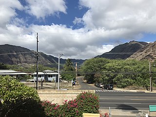
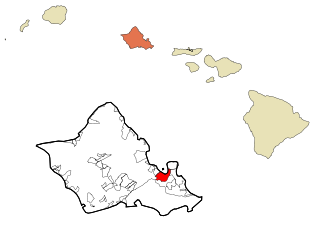
Mākaha is a census-designated place (CDP) in Honolulu County, Hawaiʻi, United States. It is a town located along the Pacific coast, west of the Mākaha Valley, and at the foot of Mt. Ka'ala in the Wai’anae Mountain Range. It is the last of the leeward towns on O'ahu. North of Mākaha there is no development, i.e. no towns, no gas stations, or restaurants. The population of Mākaha was 8,278 at the 2010 census. It is located 35 miles northwest of Honolulu, but is a part of Honolulu County.

Mililani is a city located near the center of the island of Oʻahu in Honolulu County, Hawaiʻi, United States. It consists of two census-designated places, Mililani Town, with a population of 28,121 at the 2020 census, and Mililani Mauka, with a 2020 census population of 21,075.

Schofield Barracks is a United States Army installation and census-designated place (CDP) located in the City and County of Honolulu and in the Wahiawa District of the Hawaiian island of Oʻahu, Hawaiʻi. Schofield Barracks lies adjacent to the town of Wahiawā, separated from most of it by Lake Wilson. Schofield Barracks is named after Lieutenant General John McAllister Schofield, who was the Commanding General of the United States Army from August 1888 to September 1895. He had been sent to Hawaiʻi in 1872 and had recommended the establishment of a naval base at Pearl Harbor.
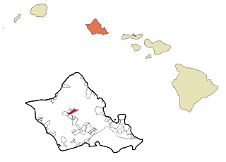
Wahiawa is a census-designated place (CDP) in Honolulu County, Hawaii, United States, on the island of Oahu. It is in the Wahiawā District, on the plateau or "central valley" between the two volcanic mountains that bookend the island. In Hawaiian, wahi a wā means "place of the wa people". The population was 18,658 at the 2020 census.

Waimalu is a census-designated place (CDP) in Honolulu County, Hawaiʻi, United States. The population was 13,817 at the 2020 census.

Hickam Housing is a census-designated place comprising part of Joint Base Pearl Harbor–Hickam in the City & County of Honolulu, Hawaii, United States. The population was 7,581 at the 2020 census. The CDP occupies the area is also referred to as Hickam Air Force Base.

Kapolei is a planned community in Honolulu County, Hawaiʻi, United States, on the island of Oʻahu. It is colloquially known as the "second city" of Oʻahu, in relation to Honolulu. For statistical purposes, the United States Census Bureau has defined Kapolei as a census-designated place (CDP) within the consolidated city-county of Honolulu.
Konawaena High School is a public school located in Kona District, Hawaii County, Hawaii, United States. Konawaena means "the center of the leeward side" in the Hawaiian Language.
Le Jardin Academy is located on the Windward Side of Oʻahu in City and County of Honolulu, Hawaiʻi. It offers private education from Pre-K to grade 12.
Honolulu Waldorf School, established in 1961, is a coeducational, independent school serving more than 300 children from early childhood through middle school located on the island of Oahu in the State of Hawaii. It previously included high school levels.
Academy of the Pacific was a private, nonsectarian co-educational high school in Honolulu CDP, Honolulu County of Hawai’i, United States. It had grades 6-12. The school closed in 2013.
Lanakila Baptist School is a college-preparatory K-12 private school located in Honolulu County, Hawaii. It serves grades sixth through twelve and has a current enrollment of about 70 students. The student population is ethnically diverse and includes Filipinos, Caucasians, part-Hawaiians, Japanese, Hispanics, Indo-Chinese, Chinese, Samoans, and African-Americans.

East Honolulu is a census-designated place (CDP) located in Honolulu County, Hawaii, United States. As of the 2020 Census, the CDP had a population of 50,922, making it the 2nd most populated CDP in Hawaii, behind Honolulu.
