
Alcester is a market town and civil parish in the Stratford-on-Avon District in Warwickshire, England. It is 8 mi (13 km) west of Stratford-upon-Avon, and 7 miles south of Redditch. The town dates back to the times of Roman Britain and is located at the junction of the River Alne and River Arrow.

Redditch is a town and borough in Worcestershire, England. It is located south of Birmingham, east of Bromsgrove, northwest of Alcester and northeast of Worcester. The borough had a population of 87,037 in 2021. In the 19th century, it became a centre for the needle and fishing tackle industry.
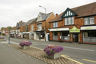
Studley is a large village and civil parish in the Stratford-on-Avon district of Warwickshire, England. Situated on the western edge of Warwickshire near the border with Worcestershire, it is 3.5 miles (6 km) southeast of Redditch and 13 miles (21 km) northwest of Stratford-upon-Avon. The Roman road of Ryknild Street, now the A435, passes through the village on its eastern edge, parallel to the River Arrow. The name derives from the Old English leah, being a meadow or pasture, where horses, stod, are kept.

A441 is an A-road in England which runs from central Birmingham to Cookhill, Worcestershire.
Feckenham is a village and civil parish in the Borough of Redditch in Worcestershire, England. It lies some 4 miles (6 km) south-west of the town of Redditch and some 11 miles (18 km) east of the city of Worcester. It had a population of 670 in the 2001 census and its immediate area is the location of notable royal manors that cover over 1,000 years of English history documented in many royal charters and Acts of Parliament. At its greatest, the historic Forest of Feckenham stretched to the River Avon in the south and to Worcester in the west. In 1389 Geoffrey Chaucer was as Clerk of Works and Keeper of the Lodge.

Ashchurch is a village and former civil parish, now in the parish of Ashchurch Rural, in the Tewkesbury district, in the county of Gloucestershire, England, 2 miles (3.2 km) east of the town of Tewkesbury, 11 mi (18 km) southwest of Evesham, 10 mi (16 km) north of Cheltenham, 13 mi (21 km) north-north-east of Gloucester and 10 mi (16 km) south of Pershore.

Sambourne, formerly spelled Sambourn, is a village and civil parish 1.5 miles (2.4 km) north-west of Coughton, 4.5 miles (7.2 km) south of Redditch, 12 miles (19 km) north-west of Stratford-upon-Avon and 20 miles (32 km) west of Warwick in the county of Warwickshire, England. It is situated on sloping ground rising westwards to about 500 feet near the ancient Ridge Way, and forms part of the county boundary with Worcestershire. The village itself is centred round a small triangular green at the junction of four roads and contains several timber-framed buildings of 17th century date. By a designation of 22 July 1991 much of the central area became a conservation area.

Redditch railway station serves the town of Redditch, North Worcestershire, England. It is the southern terminus of the Cross-City Line 14.5 miles (23 km) south of Birmingham New Street. The station, and all trains serving it, are operated by West Midlands Trains. Redditch station sits at the end of a single track branch line from Barnt Green which forms part of the Cross-City Line. The line used to continue south to Ashchurch and also Evesham but this was closed in the 1960s.
The Worcestershire County Cricket League (WCL) is an English club cricket league, and consists of club teams primarily from Worcestershire and Herefordshire, several other clubs from bordering counties Shropshire, Staffordshire and Warwickshire, and Wales.

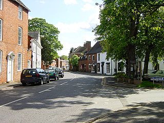
Coughton is a small village located between Studley 2.4 miles (4 km) to the North and Alcester, 2 miles (3 km) to the South, in the county of Warwickshire, England. The village lies 19.3 miles (31 km) from Birmingham on the Birmingham–Alcester A435 road, which here follows the line of the Roman road Icknield Street. The village mainly consists of a number of houses on Sambourne Lane, Coughton Lane and farms and is primarily noted as being the location of the National Trust property, Coughton Court, which lies 400 yards to the east of the A435. The population according to the 2001 Census was 139, increasing to 157 in the 2011 Census.

Callow Hill is an area of Redditch, in Worcestershire, England. Other villages nearby include Astwood Bank, Feckenham, Cookhill, and Webheath.

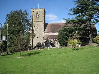
Harvington is a village near Evesham in Worcestershire, England. Bounded by the River Avon to the south and the Lench Hills to the north, three miles northeast of Evesham and now on the Worcestershire/Warwickshire border. The village today is an amalgamation of two smaller villages, Harvington and Harvington Cross, and has a population of around 1,750.

Webheath is a district of Redditch, in Worcestershire, England. The district neighbours Batchley, Headless Cross and the village of Callow Hill. It is also near Feckenham and Astwood Bank.
Redditch is a town and local government district in Worcestershire, England. The town is divided into separate districts. All street-name signs in Redditch have the street name in white lettering on a blue background and the district name in black lettering on a white background at the bottom of the sign. In the New Town areas the roads are usually named in alphabetical order and house numbering in the cul-de-sac closes is consecutive, starting with number 1 as the first house on the left as you enter, and the highest house number will be on the opposite side of the road as you leave.

The A448 is a main road in England running between Studley in Warwickshire and Kidderminster in Worcestershire.
Elcocks Brook is a hamlet in Feckenham parish, southwest of the town of Redditch, in Worcestershire, England.
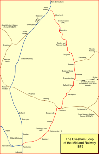
The Evesham branch line is a mostly disused English railway line running from Barnt Green via Redditch, Alcester and Evesham to Ashchurch. It was sometimes known as the Gloucester loop line of the Midland Railway.
Mappleborough Green is a small village and civil parish in Warwickshire, in the non-metropolitan district of Stratford-on-Avon. The village has a population of 540 and the civil parish 857.
Studley & Astwood Bank railway station was a station in Studley, Warwickshire, England. The station was opened on 4 May 1868, passenger train service withdrawn in 1962 officially closed to passengers on 17 June 1963 and closed completely on 6 July 1964.


