
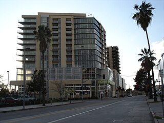
Glendale is a city in the San Fernando Valley and Verdugo Mountains regions of Los Angeles County, California, United States. At the 2020 U.S. Census the population was 196,543, up from 191,719 at the 2010 census, making it the fourth-largest city in Los Angeles County and the 24th-largest city in California. It is located about 10 miles (16 km) north of downtown Los Angeles.

The Los Angeles River, historically known as Paayme Paxaayt by the Tongva and the Río Porciúncula by the Spanish, is a major river in Los Angeles County, California. Its headwaters are in the Simi Hills and Santa Susana Mountains, and it flows nearly 51 miles (82 km) from Canoga Park through the San Fernando Valley, Downtown Los Angeles, and the Gateway Cities to its mouth in Long Beach, where it flows into San Pedro Bay. While the river was once free-flowing and frequently flooding, forming alluvial flood plains along its banks, it is currently notable for flowing through a concrete channel on a fixed course, which was built after a series of devastating floods in the early 20th century.

Atwater Village is a neighborhood in the 13th district of Los Angeles, California. Much of Atwater Village lies in the fertile Los Angeles River flood plain. Located in the northeast region of the city, Atwater borders Griffith Park and Silver Lake to the west, Glendale to the north and east and Glassell Park to the south. The eastern boundary is essentially the railroad tracks. The area has three elementary schools—two public and one private. Almost half the residents were born abroad, a high percentage for the city of Los Angeles.

Sawtelle is a neighborhood in West Los Angeles, on the Westside of Los Angeles, California. The short-lived City of Sawtelle grew around the Pacific Branch of the National Home for Disabled Volunteer Soldiers, later the Sawtelle Veterans Home, and was incorporated as a city in 1899. Developed by the Pacific Land Company, and named for its manager W. E. Sawtelle, the City of Sawtelle was independent for fewer than 30 years before it was annexed by the City of Los Angeles.

Warner Center is a master-planned neighborhood and business district development in the Canoga Park and Woodland Hills neighborhoods of the San Fernando Valley in Los Angeles, California.
The NoHo Arts District is a community in North Hollywood, Los Angeles, California, that is home to contemporary theaters, art galleries, cafes, and shops. The community is generally bounded by Hatteras Street to the north, Cahuenga Blvd to the east, Tujunga Ave to the west, and Camarillo Street to the south. The area features more than twenty professional theaters, producing new work and classics, diverse art galleries, public art, and professional dance studios. The district also features the largest concentration of music recording venues west of the Mississippi. A Metro Rail station is located here, the North Hollywood station of the B Line and serves as the terminus of the Metro G Line busway.

Glassell Park is a neighborhood of Northeast Los Angeles, California, in the San Rafael Hills.

The Verdugo Mountains, also known as the Verdugo Hills or simply The Verdugos, are a small, rugged mountain range of the Transverse Ranges system in Los Angeles County, California. Located just south of the western San Gabriel Mountains, the Verdugo Mountains region incorporates the cities of Burbank, Glendale, Pasadena, and La Cañada Flintridge; the unincorporated communities of Altadena and La Crescenta-Montrose; as well as the City of Los Angeles neighborhood of Sunland-Tujunga.
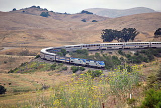
The Coast Line is a railroad line between Burbank, California and the San Francisco Bay Area, roughly along the Pacific Coast. It is the shortest rail route between Los Angeles and the Bay Area. Though not as busy as the Surf Line, the continuation of the Coast Line southbound to San Diego, it still sees freight movements and lots of passenger trains. The Pacific Surfliner, which runs from the San Diego Santa Fe Depot to San Luis Obispo via Union Station in Los Angeles, is the third busiest Amtrak route outside of the Northeast Corridor between Washington D.C. and Boston, which in turn hosts two of Amtrak's busiest routes being the Acela and the Northeast Regional.

San Fernando Road is a major street in the City of Los Angeles and Los Angeles County. Within the Burbank city limits it is signed as San Fernando Boulevard, and north of Newhall Pass it is signed as The Old Road. It was previously designated as Business Loop 5 in the 1970s.
Edendale is a historical name for a district in Los Angeles, California, northwest of Downtown Los Angeles, in what is known today as Echo Park, Los Feliz and Silver Lake. In the opening decades of the 20th century, in the era of silent movies, Edendale was known as the home of most major movie studios on the West Coast. Among its many claims, it was home to the Keystone Cops, and the site of many movie firsts, including Charlie Chaplin's first movie, the first feature-length comedy, and the first pie-in-the-face. The Edendale movie studios were mostly concentrated in a four-block stretch of Allesandro Street, between Berkeley Avenue and Duane Street. Allesandro Street was later renamed Glendale Boulevard.

The Glendale Transportation Center is an Amtrak and Metrolink train station in the city of Glendale, California. It is served by the Amtrak Pacific Surfliner intercity rail route and the Metrolink Ventura County Line and Antelope Valley Line commuter rail routes.

The historic Subway Terminal, now Metro 417, opened in 1925 at 417 South Hill Street near Pershing Square, in the core of Los Angeles as the second, main train station of the Pacific Electric Railway; it served passengers boarding trains for the west and north of Southern California through a mile-long shortcut under Bunker Hill popularly called the "Hollywood Subway," but officially known as the Belmont Tunnel. The station served alongside the Pacific Electric Building at 6th & Main, which opened in 1905 to serve lines to the south and east. The Subway Terminal was designed by Schultze and Weaver in an Italian Renaissance Revival style, and the station itself lay underground below offices of the upper floors, since repurposed into the Metro 417 luxury apartments. When the underground Red Line was built, the new Pershing Square station was cut north under Hill Street alongside the Terminal building, divided from the Subway's east end by just a retaining wall. At its peak in the 20th century, the Subway Terminal served upwards of 20 million passengers a year.

Rancho San Rafael was a 36,403-acre (147.32 km2) Spanish land grant in the San Rafael Hills, bordering the Los Angeles River and the Arroyo Seco in present-day Los Angeles County, southern California, given in 1784 to Jose Maria Verdugo.

Glendale–Burbank is a defunct Pacific Electric railway line that was operational from 1904 to 1955 in Southern California, running from Downtown Los Angeles to Burbank via Glendale. Short lines terminated Downtown and in North Glendale, including the popular Edendale Local.

Los Feliz Boulevard is a street in Glendale and Los Angeles, California, United States.

Glenoaks Boulevard is a major thoroughfare in Los Angeles County, which stretches some 22.4 miles as a north-south thoroughfare in Sylmar at its intersection with Foothill Boulevard to a west-east thoroughfare in Glendale before ending in the Scholl Canyon area as a minor street. It passes through much of the San Fernando Valley including San Fernando, Pacoima, and Sun Valley. It is also a north-south thoroughfare in Burbank. Glenoaks Boulevard runs east of and parallel to Interstate 5 in San Fernando and Burbank, and north of and parallel to State Route 134 in Glendale.

The Glendale-Hyperion Bridge is a concrete arch bridge viaduct in Atwater Village that spans the Los Angeles River and Interstate 5. The Hyperion Bridge was constructed in 1927 by vote of the citizens that lived in Atwater Village at the time and was completed in February 1929. The bridge spans 400 feet over the Atwater section of the Los Angeles River and has four car lanes. The bridge has become more widely known since the building of a small-scale replica at Disney California Adventure in Anaheim, California.

The Glendale Narrows is a scenic 11 mile section of the Los Angeles River in the Northeast Los Angeles region of Los Angeles County, California.

Owensmouth was a town founded in 1912 in the western part of the San Fernando Valley in Los Angeles County, California. Owensmouth joined the city of Los Angeles in 1917, and was renamed Canoga Park on March 1, 1931. Owensmouth was named for the 1913 Owens River aqueduct's terminus in current Canoga Park.