Avery, Texas

Last updated

Avery, Texas
Downtown Avery Wiki.jpg
Downtown Avery
TXMap-doton-Avery.PNG
Location of Avery, Texas
RedRiver County Avery.svg
Coordinates: 33°33′13″N94°46′49″W / 33.55361°N 94.78028°W / 33.55361; -94.78028
Country United States
State Texas
County Red River
Area
[1]
  Total0.97 sq mi (2.52 km2)
  Land0.95 sq mi (2.46 km2)
  Water0.03 sq mi (0.06 km2)
Elevation
472 ft (144 m)
Population
 (2010)
  Total482
  Estimate 
(2019) [2]
444
  Density467.37/sq mi (180.52/km2)
Time zone UTC-6 (Central (CST))
  Summer (DST) UTC-5 (CDT)
ZIP code
75554
Area code 903
FIPS code 48-05072 [3]
GNIS feature ID1351351 [4]

Avery is a town in Red River County, in the U.S. state of Texas. The population was 421 at the 2020 census. [5] From the 1920s through the early 1960s Avery was one of the largest tomato producing and shipping cities in northeastern Texas.

Contents

History

The town was established in the 1870s. [6] Avery is located on U.S. Highway 82, sixteen miles southeast of Clarksville in eastern Red River County. When the Texas and Pacific railroad was being constructed through the county in the 1870s, the managers of the railroad planned a station at the site and named it Douglass. Settlement in the community was slow because the surrounding area was so sparsely populated. When a correspondent of the Clarksville Standard newspaper visited Douglass in early 1881, he found a collection of families living in tents. Later that year, when Isaac Bradford and his partner opened their general store, a post office was established there, and the name of the town was changed to Isaca. In 1902 the name was changed to Avery, in honor of Ed Avery, the first railway station agent. In 1884, the population was estimated at thirty, and by 1896 it had increased to forty-eight. By 1900 Avery had three churches, a school, and a population of 176. During the first decade of the twentieth century, cotton ginning was an important local industry. By 1914, the town had two banks; a weekly newspaper, the Avery News, published by H. H. Morgan; and a population estimated at 500. The population reached its highest point in the late 1920s with a reported 800 residents, before declining sharply to a low of 300 in the early 1930s. Avery was incorporated before the 1940 census, when it reported 477 residents. The population subsequently remained relatively stable. The 1980 census recorded 520 residents, and in 1986 nine businesses were reported. In 1990 the population was 430. By 2000, the population increased to 462. [6]

Geography

Avery is located at 33°33′13″N94°46′49″W / 33.55361°N 94.78028°W / 33.55361; -94.78028 (33.553519, –94.780308). [7]

According to the United States Census Bureau, the town has a total area of 1.0 square mile (2.6 km2), of which 0.9 square miles (2.3 km2) is land and 0.04 square miles (0.10 km2) (3.06%) is water.

Demographics

Historical population
CensusPop.Note
1940 477
1950 442−7.3%
1960 343−22.4%
1970 49143.1%
1980 5205.9%
1990 430−17.3%
2000 4627.4%
2010 4824.3%
2019 (est.)444 [2] −7.9%
U.S. Decennial Census [8]

As of the census [3] of 2000, there were 462 people, 210 households, and 136 families residing in the town. The population density was 487.9 inhabitants per square mile (188.4/km2). There were 241 housing units at an average density of 254.5 per square mile (98.3/km2). The racial makeup of the town was 96.54% White, 1.30% African American, 0.22% Native American, and 1.95% from two or more races. Hispanic or Latino of any race were 0.43% of the population.

There were 210 households, out of which 26.7% had children under the age of 18 living with them, 43.8% were married couples living together, 13.8% had a female householder with no husband present, and 34.8% were non-families. 34.8% of all households were made up of individuals, and 21.4% had someone living alone who was 65 years of age or older. The average household size was 2.20 and the average family size was 2.75.

In the town, the population was spread out, with 22.7% under the age of 18, 8.9% from 18 to 24, 22.7% from 25 to 44, 25.1% from 45 to 64, and 20.6% who were 65 years of age or older. The median age was 43 years. For every 100 females, there were 88.6 males. For every 100 females age 18 and over, there were 76.7 males.

The median income for a household in the town was $21,146, and the median income for a family was $27,917. Males had a median income of $23,333 versus $16,346 for females. The per capita income for the town was $13,180. About 14.3% of families and 21.5% of the population were below the poverty line, including 22.3% of those under age 18 and 30.5% of those age 65 or over.

See also

Related Research Articles

<span class="mw-page-title-main">Red River County, Texas</span> County in Texas, United States

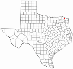
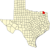
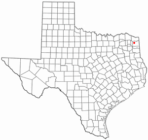
Red River County is a county in the U.S. state of Texas. As of the 2020 census, its population was 11,587. Its county seat is Clarksville. The county was created in 1835 and organized in 1837. It is named for the Red River, which forms its northern boundary. Red River County was the birthplace of John Nance Garner, 32nd Vice President of the United States.

<span class="mw-page-title-main">Maytown, Alabama</span> Town in Alabama, United States

Maytown is a town in Jefferson County, Alabama, United States. It is northwest from the Birmingham suburb of Pleasant Grove. It incorporated in October 1956. At the 2010 census the population was 385, down from 435 in 2000. This area was damaged by an F5 tornado on April 8, 1998.

<span class="mw-page-title-main">Clarksville, Indiana</span> Town in Indiana, United States

Clarksville is a town in Clark County, Indiana, United States, along the Ohio River and is a part of the Louisville Metropolitan area. The population was 22,333 at the 2020 census. The town was founded in 1783 by early resident George Rogers Clark at the only seasonal rapids on the entire Ohio River, it is the oldest American town in the former Northwest Territory. The town is home to the Colgate clock, one of the largest clocks in the world and the Falls of the Ohio State Park, home to the world's largest exposed Devonian period fossil bed.

<span class="mw-page-title-main">Fairfax, Iowa</span> City in Iowa, United States

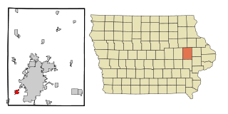
Fairfax is a city in Linn County, Iowa, United States. The population was 2,828 at the time of the 2020 census. It is part of the Cedar Rapids Metropolitan Statistical Area.

<span class="mw-page-title-main">Converse, Louisiana</span> Village in Louisiana, United States

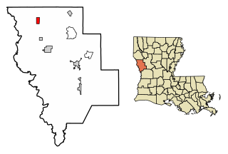
Converse is a village in Sabine Parish, Louisiana, United States. The population was 440 at the 2010 census.

<span class="mw-page-title-main">Renova, Mississippi</span> Town in Mississippi, United States

Renova is a town in Bolivar County, Mississippi, United States.Per the 2020 census, the population was 676. The community was founded by African Americans and remains predominantly African American.

<span class="mw-page-title-main">Clarksville, Missouri</span> City in Missouri, United States

Clarksville is a city in Calumet Township, Pike County, Missouri, United States. The population was 442 at the 2010 census.

<span class="mw-page-title-main">Clarksville, New Hampshire</span> Town in New Hampshire, United States

Clarksville is a town in northern Coös County, New Hampshire, United States. The population was 294 at the 2020 census. It is part of the Berlin, NH-VT Micropolitan Statistical Area.

<span class="mw-page-title-main">Clarksville, New York</span> Town in New York, United States

Clarksville is a town located in Allegany County, New York, United States. As of the 2020 census, the town had a total population of 982. The town is named after S.N. Clark, an agent of the Holland Land Company.

<span class="mw-page-title-main">Barker, Niagara County, New York</span> Village in New York, United States

Barker is a village in Niagara County, New York. The population was 533 at the time of the 2010 census. The mail ZIP code is 14012. It is part of the Buffalo–Niagara Falls Metropolitan Statistical Area.

<span class="mw-page-title-main">Clarksville, Ohio</span> Village in Ohio, United States

Clarksville is a village in Clinton County, Ohio, United States. The population was 534 at the 2020 census. It is served by the Clinton Massie branch of the Wilmington Public Library of Clinton County.

<span class="mw-page-title-main">Clarksville, Pennsylvania</span> Borough in Pennsylvania, United States

Clarksville is a borough in Greene County, Pennsylvania, United States. The population was 194 at the 2020 census.

<span class="mw-page-title-main">Livingston, South Carolina</span> Town in South Carolina, United States

Livingston is a town in Orangeburg County, South Carolina, United States. The population was 136 at the 2010 census.

<span class="mw-page-title-main">Marietta, Texas</span> Town in Texas, United States

Marietta is a town in Cass County, Texas, United States, incorporated in 1963. The population was 134 at the 2010 census, up from 112 at the 2000 census; in 2020, its population was 115.

<span class="mw-page-title-main">Neylandville, Texas</span> Town in Texas, United States

Neylandville is a town in Hunt County, Texas, United States. The population was 97 at the 2010 census, up from 56 at the 2000 census.

<span class="mw-page-title-main">Gary City, Texas</span> Town in Texas, United States

Gary City is a town in Panola County, Texas, United States. The population was 336 as of the 2020 census.

<span class="mw-page-title-main">Annona, Texas</span> Town in Texas, United States

Annona is a town in Red River County, Texas, United States. The population was 315 at the 2010 census.

<span class="mw-page-title-main">Clarksville, Texas</span> City in Texas, United States

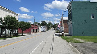
Clarksville is a city and county seat of Red River County, Texas, United States, in the northernmost part of the Piney Woods region of East Texas. As of the 2020 census, the city population was 2,857.

<span class="mw-page-title-main">Warren City, Texas</span> City in Texas, United States

Warren City is a city in Gregg and Upshur counties in the U.S. state of Texas. The population was 319 at the 2020 U.S. census.

<span class="mw-page-title-main">Grantsburg, Wisconsin</span> Village in Wisconsin, United States

Grantsburg is a village in Burnett County, Wisconsin, United States. The population was 1,341 at the 2010 census. The village is located within the Town of Grantsburg. It was established by Canute Anderson.

References

  1. "2019 U.S. Gazetteer Files". United States Census Bureau. Retrieved August 7, 2020.
  2. 1 2 "Population and Housing Unit Estimates". United States Census Bureau. May 24, 2020. Retrieved May 27, 2020.
  3. 1 2 "U.S. Census website". United States Census Bureau . Retrieved January 31, 2008.
  4. "US Board on Geographic Names". United States Geological Survey. October 25, 2007. Retrieved January 31, 2008.
  5. "Explore Census Data". data.census.gov. Retrieved May 2, 2024.
  6. 1 2 Harper, Cecil Jr (June 9, 2010). "Avery, Texas". Handbook of Texas (online ed.). Texas State Historical Association.
  7. "US Gazetteer files: 2010, 2000, and 1990". United States Census Bureau. February 12, 2011. Retrieved April 23, 2011.
  8. "Census of Population and Housing". Census.gov. Retrieved June 4, 2015.