Bainbridge, Indiana

Last updated

Bainbridge, Indiana
Bainbridge, Indiana.jpg
Ice cream stand in Bainbridge
Putnam County Indiana Incorporated and Unincorporated areas Bainbridge Highlighted 1803142.svg
Location of Bainbridge in Putnam County, Indiana.
Coordinates: 39°45′41″N86°48′41″W / 39.76139°N 86.81139°W / 39.76139; -86.81139
Country United States
State Indiana
County Putnam
Township Monroe
Area
[1]
  Total0.40 sq mi (1.04 km2)
  Land0.40 sq mi (1.04 km2)
  Water0.00 sq mi (0.00 km2)
Elevation
[2]
925 ft (282 m)
Population
 (2020)
  Total684
  Density1,705.74/sq mi (659.31/km2)
Time zone UTC-5 (EST)
  Summer (DST) UTC-5 (EST)
ZIP code
46105
Area code 765
FIPS code 18-03142
GNIS ID2396584 [2]
Website www.townofbainbridge.com

Bainbridge is a town in Monroe Township, Putnam County, in the U.S. state of Indiana. [2] The population was 746 at the 2010 census.

Contents

History

Bainbridge was laid out in 1831. [3] This town was named after the prominent war hero of the time, William Bainbridge. [4] A post office has been in operation at Bainbridge since 1835. [5] The town was incorporated in 1847. [6] The nearby National Natural Landmark of Big Walnut Creek was designated in 1985. [7]

Geography

According to the 2010 census, Bainbridge has a total area of 0.4 square miles (1.04 km2), all land. [8]

Demographics

Historical population
CensusPop.Note
1880 420
1890 47312.6%
1900 431−8.9%
1910 4494.2%
1920 4755.8%
1930 406−14.5%
1940 4142.0%
1950 4559.9%
1960 60332.5%
1970 70316.6%
1980 644−8.4%
1990 6825.9%
2000 7438.9%
2010 7460.4%
2020 684−8.3%
U.S. Decennial Census [9]

2010 census

As of the 2010 census, [10] there were 746 people, 289 households, and 198 families living in the town. The population density was 1,865.0 inhabitants per square mile (720.1/km2). There were 324 housing units at an average density of 810.0 per square mile (312.7/km2). The racial makeup of the town was 98.1% White, 0.1% Native American, 0.4% Asian, 0.3% from other races, and 1.1% from two or more races. Hispanic or Latino of any race were 0.1% of the population.

There were 289 households, of which 36.7% had children under the age of 18 living with them, 50.9% were married couples living together, 11.4% had a female householder with no husband present, 6.2% had a male householder with no wife present, and 31.5% were non-families. 26.6% of all households were made up of individuals, and 11.1% had someone living alone who was 65 years of age or older. The average household size was 2.58 and the average family size was 3.07.

The median age in the town was 37.5 years. 28.7% of residents were under the age of 18; 6.4% were between the ages of 18 and 24; 26.6% were from 25 to 44; 26.7% were from 45 to 64; and 11.7% were 65 years of age or older. The gender makeup of the town was 49.5% male and 50.5% female.

2000 census

As of the 2000 census, [11] there were 743 people, 284 households, and 218 families living in the town. The population density was 1,964.9 inhabitants per square mile (758.7/km2). There were 305 housing units at an average density of 806.6 per square mile (311.4/km2). The racial makeup of the town was 99.06% White, 0.27% African American, 0.27% Native American and 0.40% Asian. Hispanic or Latino of any race were 0.81% of the population.

There were 284 households, out of which 39.8% had children under the age of 18 living with them, 59.2% were married couples living together, 13.7% had a female householder with no husband present, and 22.9% were non-families. 20.4% of all households were made up of individuals, and 8.1% had someone living alone who was 65 years of age or older. The average household size was 2.62 and the average family size was 3.00.

In the town, the population was spread out, with 28.0% under the age of 18, 10.0% from 18 to 24, 30.7% from 25 to 44, 19.7% from 45 to 64, and 11.7% who were 65 years of age or older. The median age was 34 years. For every 100 females, there were 92.5 males. For every 100 females age 18 and over, there were 88.4 males.

The median income for a household in the town was $36,852, and the median income for a family was $37,222. Males had a median income of $27,917 versus $21,172 for females. The per capita income for the town was $14,231. About 4.8% of families and 5.5% of the population were below the poverty line, including 7.1% of those under age 18 and 4.1% of those age 65 or over.

Related Research Articles

<span class="mw-page-title-main">Milltown, Indiana</span> Town in Indiana, United States

Milltown is a town in Whiskey Run Township in Crawford County, Indiana and in Blue River and Spencer townships in Harrison County. The population was 818 at the time of the 2010 census.

<span class="mw-page-title-main">St. Paul, Indiana</span> Town in Indiana, United States

St. Paul or Saint Paul is a small town on the border of Decatur and Shelby counties in the U.S. state of Indiana. The population was 1,031 at the 2010 census.

<span class="mw-page-title-main">Ashley, Indiana</span> Town in Indiana, United States

Ashley is a town in Indiana located on the border of Smithfield Township, DeKalb County and Steuben Township, Steuben County. The population was 983 at the 2010 census.

<span class="mw-page-title-main">Albany, Indiana</span> Town in Indiana, United States

Albany is a town in Delaware and Randolph counties in the U.S. state of Indiana, along the Mississinewa River. The population was 2,295 at the 2020 census. It is part of the Muncie, IN Metropolitan Statistical Area.

<span class="mw-page-title-main">Stilesville, Indiana</span> Town in Indiana, United States

Stilesville is a town in Franklin Township, Hendricks County, Indiana, United States. The population was 316 at the 2010 Census.

<span class="mw-page-title-main">Andrews, Indiana</span> Town in Indiana, United States

Andrews is a town in Dallas Township, Huntington County, Indiana, United States. The population was 1,048 at the 2020 census.

<span class="mw-page-title-main">Kingsbury, Indiana</span> Town in Indiana, United States

Kingsbury is a town in Washington Township, LaPorte County, Indiana, just northwest of the intersection of U.S. Route 35 and U.S. Route 6. The town was founded in 1835 and incorporated on March 3, 1941. During 1940 - 1941, the Kingsbury Ordnance Plant (KOP) was built for use during World War II. The plant closed after the war but reopened during the Korean War, closing permanently in 1959. The population was 242 at the 2010 census. It is included in the Michigan City, Indiana-La Porte, Indiana Metropolitan Statistical Area. The town has its own fire department, KVFD, and a Greek revival style First Baptist church built in 1851 with its own graveyard and Winchell Cemetery.

<span class="mw-page-title-main">Woodlawn Heights, Indiana</span> Town in Indiana, United States

Woodlawn Heights is a town in Anderson Township, Madison County, Indiana, United States. It is part of the Indianapolis–Carmel–Anderson metropolitan statistical area. The population was 91 at the 2020 census.

<span class="mw-page-title-main">Bethany, Indiana</span> Town in Indiana, United States

Bethany is a town in Clay Township, Morgan County, in the U.S. state of Indiana. The population was 95 at the 2020 census.

<span class="mw-page-title-main">Paragon, Indiana</span> Town in Indiana, United States

Paragon is a town in Ray Township, Morgan County, in the U.S. state of Indiana. The population was 556 at the 2020 census, down from 659 in 2010.

<span class="mw-page-title-main">Cloverdale, Indiana</span> Town in Indiana, United States

Cloverdale is a town in Cloverdale and Warren townships, Putnam County, in the U.S. state of Indiana. The population was 2,172 at the 2010 census.

<span class="mw-page-title-main">Fillmore, Indiana</span> Town in Indiana, United States

Fillmore is a town in Marion Township, Putnam County, in the U.S. state of Indiana. The population was 532 at the 2020 census.

<span class="mw-page-title-main">Greencastle, Indiana</span> City in Indiana, United States

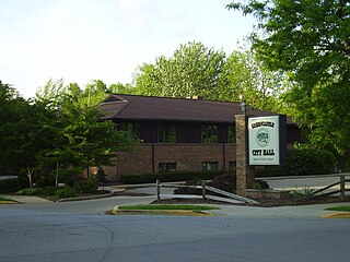
Greencastle is a city in Greencastle Township, Putnam County, Indiana, United States, and the county seat of Putnam County. It is located near Interstate 70 approximately halfway between Terre Haute and Indianapolis in the west-central portion of the state. The city is the home of DePauw University. The population was 9,820 at the 2020 census.

<span class="mw-page-title-main">Roachdale, Indiana</span> Town in Indiana, United States

Roachdale is a town in Franklin and Jackson townships, Putnam County, in the U.S. state of Indiana. The population was 926 at the 2010 census.

<span class="mw-page-title-main">Russellville, Indiana</span> Town in Indiana, United States

Russellville is a town in Russell Township, Putnam County, in the U.S. state of Indiana. The population was 358 at the 2010 census.

<span class="mw-page-title-main">Clear Lake, Indiana</span> Town in Indiana, United States

Clear Lake is a town located in the northeast corner of Steuben County, Indiana, in Clear Lake Township. As such, is the northeasternmost community in the State of Indiana. The population was 339 at the 2010 census.

<span class="mw-page-title-main">Hudson, Indiana</span> Town in Indiana, United States

Hudson is a town in Salem and Steuben townships, Steuben County, in the U.S. state of Indiana. The population was 518 at the 2010 census.

<span class="mw-page-title-main">Bainbridge, Ross County, Ohio</span> Village in Ohio, United States

Bainbridge is a village in Ross County, Ohio, United States, along Paint Creek. The population was 765 at the 2020 census.

<span class="mw-page-title-main">Bancroft, West Virginia</span> Town in West Virginia, United States

Bancroft is a town in Putnam County, West Virginia, United States, along the Kanawha River. The population was 389 at the 2020 census. It is part of the Huntington–Ashland metropolitan area.

<span class="mw-page-title-main">Spring Hill, Indiana</span> Town in Indiana, United States

Spring Hill is a town in Marion County, Indiana, United States. The population was 95 at the 2020 census. It has existed as an "included town" since 1970, when it was incorporated into Indianapolis as part of Unigov. It is part of Indianapolis, but retains town governmental powers under IC 36-3-1-11.

References

  1. "2020 U.S. Gazetteer Files". United States Census Bureau. Retrieved March 16, 2022.
  2. 1 2 3 U.S. Geological Survey Geographic Names Information System: Bainbridge, Indiana
  3. Weik, Jesse William (1910). Weik's History of Putnam County, Indiana. B.F. Bowen. p.  164.
  4. Werner, Nick (April 3, 2012). Best Hikes Near Indianapolis. FalconGuides. p. 213. ISBN   978-0-7627-7355-8.
  5. "Putnam County". Jim Forte Postal History. Retrieved November 1, 2015.
  6. Weik, Jesse William (1910). Weik's History of Putnam County, Indiana. B.F. Bowen. p.  165.
  7. "Places We Protect: Big Walnut, Indiana". Nature Conservancy . Retrieved May 22, 2023.
  8. "G001 - Geographic Identifiers - 2010 Census Summary File 1". United States Census Bureau. Archived from the original on February 13, 2020. Retrieved July 13, 2015.
  9. "Census of Population and Housing". Census.gov. Retrieved June 4, 2015.
  10. "U.S. Census website". United States Census Bureau . Retrieved December 11, 2012.
  11. "U.S. Census website". United States Census Bureau . Retrieved January 31, 2008.