Baltica

Last updated
Baltica (in white, at the centre of the image, with outline of present-day Europe for reference) Baltica outline.png
Baltica (in white, at the centre of the image, with outline of present-day Europe for reference)

Baltica is a paleocontinent that formed in the Paleoproterozoic and now constitutes northwestern Eurasia, or Europe north of the Trans-European Suture Zone and west of the Ural Mountains. The thick core of Baltica, the East European Craton, is more than three billion years old and formed part of the Rodinia supercontinent at c. 1 Ga. [1]

Contents

Tectonic history

1.1 Ga Baltica was located in what is now the South Pacific. (Current location of Australia added for reference.) Baltica 1100 Ma.png
1.1 Ga Baltica was located in what is now the South Pacific. (Current location of Australia added for reference.)
550 million years ago Baltica (green) was an isolated continent located near the South Pole. Positions of ancient continents, 550 million years ago.jpg
550 million years ago Baltica (green) was an isolated continent located near the South Pole.
Baltica in the Ordovician Period Map showing the paleogeography of the Middle Ordovician (approximately 458 million years ago). Most researchers place western (2de3cd16-15cc-4d0c-b553-71cbbeb4c7e3).jpg
Baltica in the Ordovician Period

Baltica formed at c. 2.0–1.7 Ga by the collision of three Archaean-Proterozoic continental blocks: Fennoscandia (including the exposed Baltic Shield), Sarmatia (Ukrainian Shield and Voronezh Massif), and Volgo-Uralia (covered by younger deposits). Sarmatia and Volgo-Uralia formed a proto-craton (sometimes called "Proto-Baltica") [2] at c. 2.0 Ga which collided with Fennoscandia c. 1.8–1.7 Ga. The sutures between these three blocks were reactivated during the Mesoproterozoic and Neoproterozoic. [3]

750–600 million years ago, Baltica and Laurentia rotated clockwise together and drifted away from the Equator towards the South Pole where they were affected by the Cryogenian Varanger glaciations. Initial rifting between the two continents is marked by the c. 650 Ma Egersund dike swarm in southern Norway and from 600 Ma they began to rotate up to 180° relative to each other, thus opening the Iapetus Ocean between the two landmasses. Laurentia quickly moved northward into low latitudes but Baltica remained an isolated continent in the temperate mid-latitudes of the Southern Hemisphere, closer to Gondwana, on which endemic trilobites evolved in the Early and Middle Ordovician. [4] [5]

During the Ordovician, Baltica moved northward, approaching Laurentia, which again allowed trilobites and brachiopods to cross the Iapetus Ocean. In the Silurian, c. 425 Ma, the final collision between Scotland-Greenland and Norway resulted in the closure of the Iapetus and the Scandian Orogeny. [4]

Margins

Baltica is a very old continent and its core is a very well-preserved and thick craton. Its current margins, however, are the sutures that are the result of mergers with other, much younger continental blocks. These often deformed sutures do not represent the original, Precambrian–early Palaeozoic extent of Baltica; for example, the curved margin north of the Urals running parallel to Novaya Zemlya was probably deformed during the eruption of the Siberian Traps in the Late Permian and Early Triassic. [6]

Baltica's western margin is the Caledonide orogen, which stretches northward from the Scandinavian Mountains across Barents Sea to Svalbard. Its eastern margin is the Timanide orogen which stretches north to the Novaya Zemlya archipelago. [7] The extent of the Proterozoic continent are defined by the Iapetus Suture to the west; the Trollfjorden-Komagelva Fault Zone in the north; the Variscan-Hercynian suture to the south; the Tornquist Zone to the southwest; and the Ural Mountains to the east. [8]

Northern margin

At c. 555 Ma during the Timanian Orogeny the northern margin became an active margin and Baltica expanded northward with the accretion of a series of continental blocks: the Timan-Pechora Basin, the northernmost Ural Mountains, and the Novaya Zemlya islands. This expansion coincided with the Marinoan or Varanger glaciations, also known as Snowball Earth. [9]

Terranes of the North American Cordillera, including Alaska-Chukotka, Alexander, Northern Sierra, and Eastern Klamath, share a rift history with Baltica and most likely were part of Baltica from the Caledonian orogeny until the formation of the Ural Mountains. [10] These terranes can be linked to either northeastern Laurentia, Baltica, or Siberia because of a similar sequence of fossils; detrital zircon from 2–1 Ga-old sources and evidence of Grenvillian magmatism; and magmatism and island arcs from the Late Neoproterozoic and Ordovician-Silurian. [11]

Southern margin

From at least 1.8 Ga to at least 0.8 Ga the southwestern margin of Baltica was connected to Amazonia while the southeast margin was connected to the West African Craton. Baltica, Amazonia, and West Africa rotated 75° clockwise relative to Laurentia until Baltica and Amazonia collided with Laurentia in the 1.1–0.9 Ga Grenville-Sveconorwegian-Sunsás orogenies to form the supercontinent Rodinia. When the break-up of Rodinia was complete c. 0.6 Ga Baltica became an isolated continent — a 200 million year period when Baltica was truly a separate continent. [12] Laurentia and Baltica formed a single continent until 1.265 Ga which broke up some time before 0.99 Ga. After the subsequent closure of the Mirovoi Ocean Laurentia, Baltica and Amazonia remained merged until the opening of the Iapetus Ocean in the Neoproterozoic. [13]

Western margin

The Western Gneiss Region in western Norway is composed of 1650–950 Ma-old gneisses overlain by continental and oceanic allochthons that were transferred from Laurentia to Baltica during the Scandian orogeny. The allochthons were accreted to Baltica during the closure of the Iapetus Ocean c. 430–410 Ma; Baltica's basement and the allochthons were then subducted to UHP depth c. 425–400 Ma; and they were finally exhumed to their present location c. 400–385 Ma. [14] The presence of micro-diamonds in two islands in western Norway, Otrøya and Flemsøya, indicate that this margin of Baltica was buried c. 120 km (75 mi) for at least 25 million years around 429 Ma shortly after the Baltica-Laurentia collision. [15]

The Baltica-Laurentia-Avalonia triple junction in the North Sea is the southwest corner of Baltica. The Baltica-Laurentia suture stretching northeast from the triple junction was deformed in the Late Cambrian in the Scandinavian Caledonides as well as in the Scandian Orogeny during the Silurian. Some Norwegian terranes have faunas distinct from those of either Baltica or Laurentia as a result of being island arcs that originated in the Iapetus Ocean and were later accreted to Baltica. The Baltica craton most likely underlies these terranes and the continent-ocean boundary passes several kilometres off Norway, but, since the North Atlantic opened c. 54 Ma where the Iapetus Ocean closed, it is unlikely the craton also reached into Laurentia. The margin stretches north to Novaya Zemlya where early Palaeozoic Baltica faunas have been found, but the sparsity of data makes it difficult to locate the margin in the Arctic. Ordovician faunas indicate that most of Svalbard, including Bjørnøya, was part of Laurentia, but Franz Josef Land and Kvitøya (an eastern island of the Svalbard archipelago) most likely became part of Baltica in the Timanide Orogeny. The Taymyr Peninsula, in contrast, never was part of Baltica: southern Taymyr was part of Siberia whilst northern Taymyr and the Severnaya Zemlya archipelago were part of the independent Kara Terrane in the early Palaeozoic. [16]

Eastern margin

The eastern margin, the Uralide orogen, extends 2,500 km (1,600 mi) from the Arctic Novaya Zemlya archipelago to the Aral Sea. The orogen contains the record of at least two collisions between Baltica and intra-oceanic island arcs before the final collision between Baltica and Kazakhstania-Siberia during the formation of Pangaea. The Silurian-Devonian island arcs were accreted to Baltica along the Main Uralian Fault, east of which are metamorphosed fragments of volcanic arc mixed with small amounts of Precambrian and Paleozoic continental rocks. However, no rocks unambiguously originating from either Kazakhstania or Siberia have been found in the Urals. [17] The basement of the eastern margin is composed of an Archaean craton, metamorphosed rocks at least 1.6 Ga old, which is surrounded by the fold belt of the Timanide orogeny and overlain by Mesoproterozoic sediments. The margin became a passive margin facing the Ural Ocean in the Cambrian–Ordovician. [18]

The eastern margin stretches south through the Ural Mountains from the northern end of the Novaya Zemlya archipelago. The margin follows the bent shape of Novaya Zemlya which was caused in the Late Permian by the Siberian Traps. It is clear from Baltic endemic fossils in Novaya Zemlya that the islands have been part of Baltica since the Early Palaeozoic, whereas the Taymyr Peninsula farther east was part of the passive margin of Siberia in the Early Palaeozoic. Northern Taymyr, together with Severnaya Zemlya and parts of the crust of the Arctic Ocean, formed the Kara Terrane. [19]

The Urals Mountains formed in the mid and late Palaeozoic when Laurussia collided with Kazakhstania, a series of terranes. The eastern margin, however, originally extended farther east to an active margin bordered by island arcs, but those parts have been compressed, fractured, and distorted especially in the eastern Urals. The early Palaeozoic eastern margin is better preserved south of the polar region (65 °N) where shallow-water sediments can be found in the western Urals whilst the eastern Urals are characterised by deep-water deposits. The oldest known mid-ocean hydrothermal vent in the south-central part of the Urals clearly delimits the eastern extent. The straightness of the mountain chain is the result of continuous strike-slip movements during the Late Carboniferous to Early Permian (300–290 Ma). [19]

Baltic endemic faunas from the Early Ordovician have been found in Kazakhstan near the southern end of the eastern margin, or the triple junction between Baltica, the Mangyshlak Terrane, and the accretionary Altaids. Here the Early Palaeozoic rocks are buried under the Caspian Depression. [19]

See also

Related Research Articles

<span class="mw-page-title-main">Rodinia</span> Hypothetical Neoproterozoic supercontinent

Rodinia was a Mesoproterozoic and Neoproterozoic supercontinent that assembled 1.26–0.90 billion years ago and broke up 750–633 million years ago. Valentine & Moores 1970 were probably the first to recognise a Precambrian supercontinent, which they named 'Pangaea I'. It was renamed 'Rodinia' by McMenamin & McMenamin 1990 who also were the first to produce a reconstruction and propose a temporal framework for the supercontinent.

<span class="mw-page-title-main">Laurasia</span> Northern landmass that formed part of the Pangaea supercontinent

Laurasia was the more northern of two large landmasses that formed part of the Pangaea supercontinent from around 335 to 175 million years ago (Mya), the other being Gondwana. It separated from Gondwana 215 to 175 Mya during the breakup of Pangaea, drifting farther north after the split and finally broke apart with the opening of the North Atlantic Ocean c. 56 Mya. The name is a portmanteau of Laurentia and Asia.

<span class="mw-page-title-main">Iapetus Ocean</span> Ocean that existed in the late Neoproterozoic and early Paleozoic eras

The Iapetus Ocean was an ocean that existed in the late Neoproterozoic and early Paleozoic eras of the geologic timescale. The Iapetus Ocean was situated in the southern hemisphere, between the paleocontinents of Laurentia, Baltica and Avalonia. The ocean disappeared with the Acadian, Caledonian and Taconic orogenies, when these three continents joined to form one big landmass called Euramerica. The "southern" Iapetus Ocean has been proposed to have closed with the Famatinian and Taconic orogenies, meaning a collision between Western Gondwana and Laurentia.

<span class="mw-page-title-main">Columbia (supercontinent)</span> Ancient supercontinent of approximately 2,500 to 1,500 million years ago

Columbia, also known as Nuna or Hudsonland, was one of Earth's ancient supercontinents. It was first proposed by John J.W. Rogers and M. Santosh in 2002 and is thought to have existed approximately 2,500 to 1,500 million years ago, in the Paleoproterozoic Era. The assembly of the supercontinent was likely completed during global-scale collisional events from 2100 to 1800 million years ago.

<span class="mw-page-title-main">Arctica</span> Ancient continent in the Neoarchean era

Arctica, or Arctida was an ancient continent which formed approximately 2.565 billion years ago in the Neoarchean era. It was made of Archaean cratons, including the Siberian Craton, with its Anabar/Aldan shields in Siberia, and the Slave, Wyoming, Superior, and North Atlantic cratons in North America. Arctica was named by Rogers 1996 because the Arctic Ocean formed by the separation of the North American and Siberian cratons. Russian geologists writing in English call the continent "Arctida" since it was given that name in 1987, alternatively the Hyperborean craton, in reference to the hyperboreans in Greek mythology.

<span class="mw-page-title-main">Pannotia</span> Hypothesized Neoproterozoic supercontinent from the end of the Precambrian

Pannotia, also known as the Vendian supercontinent, Greater Gondwana, and the Pan-African supercontinent, was a relatively short-lived Neoproterozoic supercontinent that formed at the end of the Precambrian during the Pan-African orogeny, during the Cryogenian period and broke apart 560 Ma with the opening of the Iapetus Ocean, in the late Ediacaran and early Cambrian. Pannotia formed when Laurentia was located adjacent to the two major South American cratons, Amazonia and Río de la Plata. The opening of the Iapetus Ocean separated Laurentia from Baltica, Amazonia, and Río de la Plata. In 2022 the whole concept of Pannotia has been put into question by scientists who argue its existence is not supported by geochronology, "the supposed landmass had begun to break up well before it was fully assembled".

<span class="mw-page-title-main">Avalonia</span> Microcontinent in the Paleozoic era named for the Avalon Peninsula in Newfoundland

Avalonia was a microcontinent in the Paleozoic era. Crustal fragments of this former microcontinent underlie south-west Great Britain, southern Ireland, and the eastern coast of North America. It is the source of many of the older rocks of Western Europe, Atlantic Canada, and parts of the coastal United States. Avalonia is named for the Avalon Peninsula in Newfoundland.

<span class="mw-page-title-main">Congo Craton</span> Precambrian craton that with four others makes up the modern continent of Africa

The Congo Craton, covered by the Palaeozoic-to-recent Congo Basin, is an ancient Precambrian craton that with four others makes up the modern continent of Africa. These cratons were formed between about 3.6 and 2.0 billion years ago and have been tectonically stable since that time. All of these cratons are bounded by younger fold belts formed between 2.0 billion and 300 million years ago.

<span class="mw-page-title-main">Acadian orogeny</span> North American orogeny

The Acadian orogeny is a long-lasting mountain building event which began in the Middle Devonian, reaching a climax in the early Late Devonian. It was active for approximately 50 million years, beginning roughly around 375 million years ago, with deformational, plutonic, and metamorphic events extending into the Early Mississippian. The Acadian orogeny is the third of the four orogenies that formed the Appalachian orogen and subsequent basin. The preceding orogenies consisted of the Potomac and Taconic orogeny, which followed a rift/drift stage in the Late Neoproterozoic. The Acadian orogeny involved the collision of a series of Avalonian continental fragments with the Laurasian continent. Geographically, the Acadian orogeny extended from the Canadian Maritime provinces migrating in a southwesterly direction toward Alabama. However, the Northern Appalachian region, from New England northeastward into Gaspé region of Canada, was the most greatly affected region by the collision.

<span class="mw-page-title-main">Caledonian orogeny</span> Mountain building event caused by the collision of Laurentia, Baltica and Avalonia

The Caledonian orogeny was a mountain-building era recorded in the northern parts of the British Isles, the Scandinavian Mountains, Svalbard, eastern Greenland and parts of north-central Europe. The Caledonian orogeny encompasses events that occurred from the Ordovician to Early Devonian, roughly 490–390 million years ago (Ma). It was caused by the closure of the Iapetus Ocean when the continents and terranes of Laurentia, Baltica and Avalonia collided.

The Uralian orogeny refers to the long series of linear deformation and mountain building events that raised the Ural Mountains, starting in the Late Carboniferous and Permian periods of the Palaeozoic Era, c. 323–299 and 299–251 million years ago (Mya) respectively, and ending with the last series of continental collisions in Triassic to early Jurassic times.

The Rheic Ocean was an ocean which separated two major palaeocontinents, Gondwana and Laurussia (Laurentia-Baltica-Avalonia). One of the principal oceans of the Palaeozoic, its sutures today stretch 10,000 km (6,200 mi) from Mexico to Turkey and its closure resulted in the assembly of the supercontinent Pangaea and the formation of the Variscan–Alleghenian–Ouachita orogenies.

<span class="mw-page-title-main">Wyoming Craton</span> Craton in the west-central United States and western Canada

The Wyoming Craton is a craton in the west-central United States and western Canada – more specifically, in Montana, Wyoming, southern Alberta, southern Saskatchewan, and parts of northern Utah. Also called the Wyoming Province, it is the initial core of the continental crust of North America.

<span class="mw-page-title-main">Laurentia</span> A large continental craton that forms the ancient geological core of the North American continent

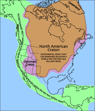
Laurentia or the North American Craton is a large continental craton that forms the ancient geological core of North America. Many times in its past, Laurentia has been a separate continent, as it is now in the form of North America, although originally it also included the cratonic areas of Greenland and also the northwestern part of Scotland, known as the Hebridean Terrane. During other times in its past, Laurentia has been part of larger continents and supercontinents and itself consists of many smaller terranes assembled on a network of Early Proterozoic orogenic belts. Small microcontinents and oceanic islands collided with and sutured onto the ever-growing Laurentia, and together formed the stable Precambrian craton seen today.

<span class="mw-page-title-main">Carolina terrane</span> Exotic terrane from central Georgia to central Virginia in the United States

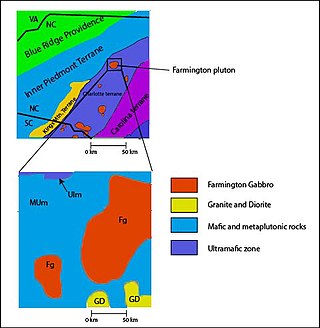
The Carolina Terrane, also called the Carolina Superterrane or Carolinia, is an exotic terrane running ~370 miles (600 km) approximately North-South from central Georgia to central Virginia in the United States. It constitutes a major part of the eastern Piedmont Province.

<span class="mw-page-title-main">East Antarctic Shield</span> Cratonic rock body which makes up most of the continent Antarctica

The East Antarctic Shield or Craton is a cratonic rock body that covers 10.2 million square kilometers or roughly 73% of the continent of Antarctica. The shield is almost entirely buried by the East Antarctic Ice Sheet that has an average thickness of 2200 meters but reaches up to 4700 meters in some locations. East Antarctica is separated from West Antarctica by the 100–300 kilometer wide Transantarctic Mountains, which span nearly 3,500 kilometers from the Weddell Sea to the Ross Sea. The East Antarctic Shield is then divided into an extensive central craton that occupies most of the continental interior and various other marginal cratons that are exposed along the coast.

<span class="mw-page-title-main">Terra Australis Orogen</span>

The Terra Australis Orogen (TAO) was the oceanic southern margin of Gondwana which stretched from South America to Eastern Australia and encompassed South Africa, West Antarctica, New Zealand and Victoria Land in East Antarctica.

<span class="mw-page-title-main">Scandinavian Caledonides</span> Remains of an orogenic belt formed during the Silurian–Devonian period

The Scandinavian Caledonides are the vestiges of an ancient, today deeply eroded orogenic belt formed during the Silurian–Devonian continental collision of Baltica and Laurentia, which is referred to as the Scandian phase of the Caledonian orogeny. The size of the Scandinavian Caledonides at the time of their formation can be compared with the size of the Himalayas. The area east of the Scandinavian Caledonides, including parts of Finland, developed into a foreland basin where old rocks and surfaces were covered by sediments. Today, the Scandinavian Caledonides underlay most of the western and northern Scandinavian Peninsula, whereas other parts of the Caledonides can be traced into West and Central Europe as well as parts of Greenland and eastern North America.

The Albany-Fraser orogeny was an orogenic event which created the Albany-Fraser Orogen in what is now Australia between 2.63 and 1.16 billion years ago, during the late Archean and Proterozoic. Tectonic history developed from isotope dating suggests that the orogeny occurred as the combined North Australia Craton-West Australia Craton collided with the East Antarctic-South Australian Craton. The Kepa Kurl Booya Province, including its component zones, the Fraser Zone, Nornalup Zone and Biranup Zone represents the crystalline basement of the orogen. Numerous theories and hypotheses have been presented about the orogeny. For example, in 2011 geochronology dating of 1.71 to 1.65 billion year old granite and gabbro intrusions in the Biranup Zone suggested craton margin rocks rather than a previously interrupted small terrane wedged against the Yilgarn Craton. In other cases, researchers attempting to reconstruct the supercontinent Rodinia suggested a possible connection between Australia-Antarctica and the proto-North American continent Laurentia, but in 2003 paleomagnetic data from the Albany-Fraser orogeny suggested that Australia and Laurentia were at different latitudes.

<span class="mw-page-title-main">Yavapai orogeny</span> Mountain building event 1.7 billion years ago in the southwestern United States

The Yavapai orogeny was an orogenic (mountain-building) event in what is now the Southwestern United States that occurred between 1710 and 1680 million years ago (Mya), in the Statherian Period of the Paleoproterozoic. Recorded in the rocks of New Mexico and Arizona, it is interpreted as the collision of the 1800-1700 Mya age Yavapai island arc terrane with the proto-North American continent. This was the first in a series of orogenies within a long-lived convergent boundary along southern Laurentia that ended with the ca. 1200–1000 Mya Grenville orogeny during the final assembly of the supercontinent Rodinia, which ended an 800-million-year episode of convergent boundary tectonism.

References

Notes

  1. Cocks & Torsvik 2005 , Abstract
  2. E.g. Torsvik & Cocks 2005 , Norway's earliest times, pp. 74–75
  3. Bogdanova et al. 2008 , The crustal segments of the East European Craton, pp. 2–3
  4. 1 2 Torsvik et al. 1996 , Abstract
  5. Pärnaste, Helje; Bergström, Jan (1 November 2013). "The asaphid trilobite fauna: Its rise and fall in Baltica". Palaeogeography, Palaeoclimatology, Palaeoecology . 389: 64–77. Bibcode:2013PPP...389...64P. doi:10.1016/j.palaeo.2013.06.007.
  6. Cocks & Torsvik 2005 , The margins of Baltica, p. 41
  7. Gee, Bogolepova & Lorenz 2006 , p. 507
  8. Torsvik et al. 1992 , Introduction, pp. 133–137
  9. Walderhaug, Torsvik & Halvorsen 2007 , Baltica and Varangian Glaciations, pp. 946–947; Fig. 12, p. 946
  10. Miller et al. 2011 , Abstract
  11. Colpron & Nelson 2009 , Terranes of Siberian, Baltican and Caledonian affinities, pp. 280–281
  12. Johansson 2009 , Abstract
  13. Cawood & Pisarevsky 2017 , Abstract
  14. Hacker et al. 2010 , Western Gneiss Region, pp. 150–151
  15. Spengler et al. 2009 , Abstract; Conclusion and implications, pp. 33–34
  16. Cocks & Torsvik 2005 , The margins of Baltica, p. 42–44
  17. Brown et al. 2006 , Geological framework of the Uralides, p. 262; For a model of the arc-continent collision see Puchkov 2009 , Fig. 12, p. 178; Fig. 14, p. 180
  18. Brown et al. 2006 , The Paleozoic continental margin of Baltica in the Southern Urals, pp. 262–266
  19. 1 2 3 Cocks & Torsvik 2005 , The margins of Baltica, p. 44–45

Sources