
The Senegal River is a 1086 km (675 mi) long river in West Africa; much of its length marks part of the border between Senegal and Mauritania. It has a drainage basin of 270000 km2, a mean flow of 680 m3/s (24,000 cu ft/s), and an annual discharge of 21.5 km3 (5.2 cu mi). Important tributaries are the Falémé River, Karakoro River, and the Gorgol River. The river divides into two branches once it passes Kaédi The left branch, called the Doué, runs parallel to the main river to the north. After 200 km (120 mi) the two branches rejoin a few kilometers downstream of Podor.

The Mali Empire was an empire in West Africa from c. 1226 to 1670. The empire was founded by Sundiata Keita and became renowned for the wealth of its rulers, especially Mansa Musa. At its peak, Mali was the largest empire in West Africa, widely influencing the culture of the region through the spread of its language, laws and customs.
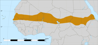
The Sahelian kingdoms were a series of centralized kingdoms or empires that were centered on the Sahel, the area of grasslands south of the Sahara, from the 8th century to the 19th. The wealth of the states came from controlling the trade routes across the desert. Their power came from having large pack animals like camels and horses that were fast enough to keep a large empire under central control and were also useful in such kind of battle. All of these empires were also quite decentralized with member cities having a great deal of autonomy.
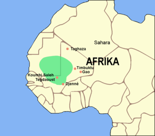
Koumbi Saleh, or Kumbi Saleh, is the site of a ruined ancient and medieval city in south east Mauritania that may have been the capital of the Ghana Empire.

Bundu was a state in West Africa existing from the late 17th century until it became a French protectorate dependent on the colony of Senegal. It lay between the Falémé River and the upper course of the Gambia River, that is between 13 and 15 N., and 12 and 13 W.

Siguiri is a city in northeastern Guinea on the River Niger. It is a sub-prefecture and capital of Siguiri Prefecture in the Kankan Region. Its population was estimated at 28,319 in 2008.
Upper Guinea is a geographical term used in several contexts:
- Upper Guinea is one of the four geographic regions of the Republic of Guinea, being east of Futa Jalon, north of Forest Guinea, and bordering Mali. The population of this region is mainly Malinke.
- In a larger sense, it refers to a large plain covering eastern Guinea, Sierra Leone, Liberia and extending into north western Côte d'Ivoire. Mostly forming the upper watershed of the River Niger, it is sparsely populated and is home to the Haut Niger National Park.
- Upper Guinea can also refer to the interior part of the wider Guinea region, bordering the Sahel. The interior regions are largely defined by the watersheds of rivers that arise from Fouta Djallon, including the Niger, Senegal, Faleme and others. The term was widely applied during the sixteenth to nineteenth centuries to describe a coastal region and its related hinterland with which Europeans traded.
- In biogeography, Upper Guinea refers the region of tropical rainforest extending from southwestern Guinea through Sierra Leone, Liberia, southeastern Guinea, Côte d'Ivoire, and southwestern Ghana. The Dahomey Gap, a drier region of Ghana, Togo, and Benin where the Guinean forest-savanna mosaic extends to the Gulf of Guinea, separates Upper Guinea from the tropical rainforests of Lower Guinea further east. The Upper Guinea forests are also recognized as an endemic bird area.

Kayes Region is one of ten first level national subdivisions in Mali called Regions. It is the first administrative area of Mali and covers an area of 120,760 square kilometres or 46,630 square miles. Its capital is the town of Kayes. The province was historically part of the Ghana Empire and the Mali Empire.

The Soninke people are a West African Mande-speaking ethnic group found in Mali, southern Mauritania, eastern Senegal, The Gambia, and Guinea. They speak the Soninke language, also called the Serakhulle or Azer language, which is one of the Mande languages. Soninke people were the founders of the ancient empire of Ghana or Wagadou c. 200–1240 CE, Subgroups of Soninke include the Jakhanke, Maraka and Wangara. When the Ghana empire was destroyed, the resulting diaspora brought Soninkes to Mali, Mauritania, Senegal, Gambia, Burkina Faso, Côte d'Ivoire, Guinée-Conakry, modern-day Republic of Ghana, Kano in Nigeria, and Guinea-Bissau where some of this trading diaspora was called Wangara.
The Wangara are a subgroup of the Soninke who later became assimilated merchant classes that specialized in both Trans Saharan and Secret Trade of Gold Dust. Their diaspora operated all throughout West Africa Sahel-Sudan. Fostering regionally organized trade networks and Architecture projects. But based in the many Sahelian and Niger-Volta-Sene-Gambia river city-states. Particularly Dia, Timbuktu, Agadez, Kano, Gao, Koumbi Saleh, Guidimaka, Salaga, Kong, Bussa, Bissa, Kankan, Jallon, Djenné as well as Bambouk, Bure, Lobi, and Bono State goldfields and Borgu. They also were practicing Muslims with a clerical social class (Karamogo), Timbuktu Alumni political advisors, Sufi Mystic healers and individual leaders (Marabout). Living by a philosophy of mercantile pacifism called the Suwarian Tradition. Teaching peaceful coexistence with non-Muslims, reserving Jihad for self-defence only and even serving as Soothsayers or a "priesthood" of literate messengers for non-Muslim Chiefdoms/Kingdoms. This gave them a degree of control and immense wealth in lands where they were the minority. Creating contacts with almost all West African religious denominations. A group of Mande traders, loosely associated with the Kingdoms of the Sahel region and other West African Empires. Such as Ghana, Mali, Songhai, Bono State, Kong, Borgu, Dendi, Macina, Hausa Kingdoms & the Pashalik of Timbuktu. Wangara also describes any land south of Timbuktu and Agadez. The Bilad-Al-Sudan or Bilad-Al-Tibr, "Land of Black" or "Gold."
Pre-imperial Mali refers to the period of history before the establishment of the Mali Empire, an African empire located mostly in present-day Mali, in c. 1235.

Kéniéba Cercle is a subdivision of the Kayes Region of Mali. The administrative center (chef-lieu) is the town of Kéniéba.
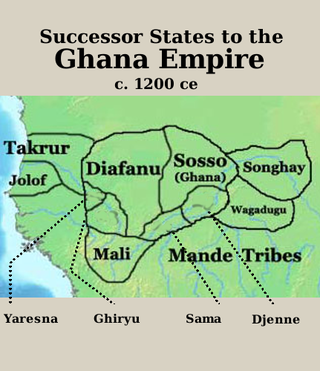
The Ghana Empire, also known as simply Ghana, Ghanata, or Wagadou, was a West African classical to post-classical era western-Sahelian empire based in the modern-day southeast of Mauritania and western Mali. With the collapse of the Dhar Tichitt culture circa 400 B.C.E, The Ghana Empire's latency phase is hypothesized to have spanned from the 4th century B.C.E to approximately the 1st century C.E. with the eventual imperial state materializing between the 1st and 3rd centuries C.E. ultimately dissolving in the 1300s.

The Birimian rocks are major sources of gold and diamonds that extend through Ghana, Côte d'Ivoire, Guinea, Mali and Burkina Faso. They are named after the Birim River, one of the main tributaries of the Pra River in Ghana and the country's most important diamond-producing area. Ghana and Mali are the second and third largest producers of gold in Africa, respectively.
The Jakhanke -- also spelled Jahanka, Jahanke, Jahanque, Jahonque, Diakkanke, Diakhanga, Diakhango, Dyakanke, Diakhanké, Diakanké, or Diakhankesare -- are a Manding-speaking ethnic group in the Senegambia region, often classified as a subgroup of the larger Soninke. The Jakhanke have historically constituted a specialized caste of professional Muslim clerics (ulema) and educators. They are centered on one larger group in Guinea, with smaller populations in the eastern region of The Gambia, Senegal, and in Mali near the Guinean border. Although generally considered a branch of the Soninke, their language is closer to Western Manding languages such as Mandinka.
The Gao Empire preceded the Songhai Empire in the region of the Middle Niger. It owes its name to the town of Gao located at the eastern Niger bend.

Starting out as a seasonal settlement, Timbuktu was in the kingdom of Mali when it became a permanent settlement early in the 12th century. After a shift in trading routes, the town flourished from the trade in salt, gold, ivory and slaves from several towns and states such as Begho of Bonoman, Sijilmassa, and other Saharan cities. It became part of the Mali Empire early in the 14th century. By this time it had become a major centre of learning in the area. In the first half of the 15th century the Tuareg tribes took control of the city for a short period until the expanding Songhai Empire absorbed the city in 1468. The Moroccan army defeated the Songhai in 1591, and made Timbuktu, rather than Gao, their capital.
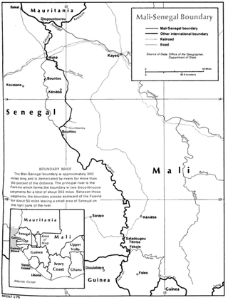
The Mali–Senegal border is 489 km in length and runs from the tripoint with Mauritania in the north to the tripoint with Guinea in the south.

The Burkina Faso–Ghana border is 602 km in length and runs from the tripoint with Ivory Coast in the west to the tripoint with Togo in the east.

Manding, Manden or even Mandé is a region located in West Africa, a space between southern Mali and eastern Guinea. It is the historic home of the Mandinka community.
