Anambas Islands Regency is a small archipelago of Indonesia, located 150 nautical miles northeast of Batam Island in the North Natuna Sea between the Malaysian mainland to the west and the island of Borneo to the east. Geographically part of the Tudjuh Archipelago, it is administratively a regency within the Riau Islands Province. It covers a land area of 590.14 square kilometres (227.85 sq mi) and had a population of 37,411 at the 2010 Census and 47,402 at the 2020 Census; the official estimate as at mid 2022 was 50,296. The administrative centre is at Tarempa on Siantan Island.

Nunukan Regency is a regency of North Kalimantan Province in Indonesia. It was created on 4 October 1999 from the northern districts of Bulungan Regency. Nunukan Regency shares international borders with the Malaysian states of Sabah to the north and Sarawak to the west, and inter-regency borders with Tana Tidung Regency and Malinau Regency to the south, as well as the coastal city of Tarakan in the east. The regency covers an area of 14,247.50 km2 and it had a population of 140,841 at the 2010 census and 199,090 at the 2020 census; the official estimate as at mid 2023 was 217,923.

North Bengkulu is a regency of Bengkulu Province, Indonesia, on the island of Sumatra. It originally covered much of the northern part of Bengkulu Province, but on 25 February 2003 the most northwesterly districts were split off to form a separate Mukomuko Regency, and on 24 June 2008 the most southeastern districts were likewise split off to create a new Central Bengkulu Regency. The residual regency now covers an area of 4,424.59 km2, and it had a population of 257,675 at the 2010 Census and 296,523 at the 2020 Census; the official estimate as at mid 2022 was 302,833. The administrative centre is at the town of Arga Makmur.

Bone Bolango is a regency of Gorontalo Province, Indonesia, on the island of Sulawesi. It was established in 2003 under Law Number 6/2003from the former eastern districts of Gorontalo Regency. It has an area of 1,915.44 km2 and had a population of 141,915 at the 2010 Census and 162,778 at the 2020 Census; the official estimate as at mid 2023 was 172,301. The administrative centre of the regency is the town of Suwawa.

North Gorontalo is a regency of Gorontalo Province, Indonesia, stretching along the entire northern coast of the province. It is located on the northern peninsula of the island of Sulawesi. It was established on 2 January 2007 under Law Number 11/2007 from the former northern districts of Gorontalo Regency. The new regency has an area of 1,777.02 km2, and it had a population of 104,133 at the 2010 Census and 124,957 at the 2020 Census; the official estimate as at mid 2023 was 130,400. Its regency seat is the town of Moluo in Kwandang District.

Manggarai Regency is a regency in East Nusa Tenggara province of Indonesia, situated on the island of Flores. Established in 1958 the regency was reduced in size and population by the separation of the more western districts to form West Manggarai Regency in 2003 and of the more eastern districts to form East Manggarai Regency in 2007. The area of the residual Manggarai Regency is 1,343.83 km2 and its population was 292,037 at the 2010 census and 312,855 at the 2020 census; the official estimate as at mid 2023 was 328,758. The capital of the regency is the town of Ruteng.

North Barito Regency is one of the thirteen regencies which divide the Central Kalimantan Province on the island of Kalimantan, Indonesia. It originally included much more of the northern part of the province, but on 10 April 2002 the larger northwestern part of the regency was split off to create a new Murung Raya Regency. Muara Teweh is the capital of North Barito Regency, which covers an area of 10,152.25 km2. The population of North Barito Regency was 121,573 at the 2010 Census and 154,812 at the 2020 Census; the official estimate as at mid 2023 was 160,605.

North Luwu Regency is a regency of South Sulawesi Province of Indonesia. It was created on 20 April 1999 by separation of the province's northern districts formerly within the Luwu Regency; however on 25 February 2003 it was reduced when the easternmost of these same districts were split off to create the East Luwu Regency. It now covers 7,502.58 km2 and had a population of 287,606 at the 2010 census and 322,919 at the 2020 census; the official estimate as at mid 2023 was 333,127. The principal town lies at Masamba.

The Pangkajene and Islands Regency, is a regency of South Sulawesi province of Indonesia. The regency lies primarily on the mainland of Sulawesi's southern peninsula, but also includes the Spermonde Islands off the west coast of that peninsula, as well as other small islands further west and southwest. The principal town lies at Pangkajene on Sulawesi, but there are a series of further small towns like Lejang, Labakkang, Bonto-Bonto and Segeri proceeding northwards from Pangkajene along the Trans-Sulawesi Highway. The total land area is 1,112.29 km2, and the population was 305,737 at the 2010 Census and 345,775 at the 2020 Census; the official population estimate as of mid-2023 was 357,846.

Takalar Regency is a regency of South Sulawesi Province, Indonesia. It covers an area of 566.51 km2 and had a population of 269,603 at the 2010 census and 300,853 at the 2020 census; the official estimate for mid 2023 was 326,044. The entire regency lies within the official metropolitan area of the city of Makassar. The principal towns are at Galesong and Takalar, but the administrative centre is at Pattallassang.

North Konawe Regency is a regency of Southeast Sulawesi Province, Indonesia. It was formed on 2 January 2007 by splitting off seven of the northern districts of Konawe Regency to form a new North Konawe Regency. It is surrounded on all landward sides by the remaining area of the Konawe Regency, except in the northeast, where it borders on Sulawesi Tengah Province. It covers a land area of 5,101.76 km2. It had a population of 51,447 at the 2010 Census and 67,871 at the 2020 Census; the official estimate as at mid 2023 was 77,391 - comprising 39,823 males and 37,568 females. The principal town lies at Asera.

The Banggai Archipelago is a group of islands located at the far eastern end of Central Sulawesi, Indonesia. It makes up a regency (kabupaten) of Central Sulawesi Province of Indonesia, created on 4 October 1999 by splitting the existing Banggai Regency into a residual Banggai Regency situated on the mainland of Sulawesi and a new Banggai Islands Regency then comprising the entire archipelago. On 14 December 2012 a splitting of the Banggai Islands archipelago took place with the removal of the more southerly seven districts from the 13-year-old regency to form a separate Banggai Laut Regency.

Poso Regency is a regency of Central Sulawesi Province of Indonesia. It covers an area of 7,438.55 km2, and had a population of 209,228 at the 2010 Census and 244,875 at the 2020 Census; the official estimate as at mid 2023 was 251,654. The principal town lies at Poso.
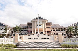
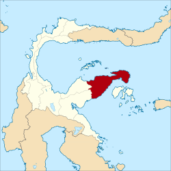
Tojo Una-Una Regency is a regency of Central Sulawesi, Indonesia. The administrative centre is at Ampana town, on the Sulawesi 'mainland'. While the Regency includes a considerable area on the eastern peninsula of Sulawesi, it also includes the Togian Islands in the Gulf of Tomini. The total area covers 5,721.51 km2 and the population was 134,945 at the 2010 Census and 163,829 at the 2020 Census; the official estimate as at mid 2023 was 169,002.

Minahasa Regency is a regency in North Sulawesi, Indonesia. Its capital is Tondano. It covers an area of 1,141.64 km2 and had a population of 310,384 at the 2010 Census; this rose to 347,290 at the 2020 Census, and the official estimate as at mid 2023 was 351,920.

Southwest Maluku Regency is a regency of Maluku Province, Indonesia. Geographically it forms the most eastern portion of the Lesser Sunda Islands, although it has never been administratively included with them, and politically has always comprised a part of the Maluku Province. It comprises a number of islands and island groups in the south of the province, including Lirang Island, Wetar Island, Kisar Island, Romang Island, the Letti Islands, the Damer Islands, the Sermata Islands and the Babar Islands. The total land area is 4,581.06 km2, and the population was 70,714 at the 2010 Census and 81,928 at the 2020 Census; the official estimate as at mid 2023 was 93,766.

North Toraja is a landlocked regency (kabupaten) of South Sulawesi Province of Indonesia, and the home of the Toraja ethnic group. The local government seat is in Rantepao which is also the center of Toraja culture. Formerly this regency was the northern part of Tana Toraja Regency, but on 24 June 2008 the northeastern 36% of the latter's area was split off to form this separate North Toraja Regency. It covers an area of 1,289.13 km2 and had a population of 216,762 at the 2010 census and 261,086 at the 2020 census; the official estimate as at mid 2023 was 261,652, comprising 133,529 males and 128,123 females.

The East Kolaka Regency is a new and the only landlocked regency of Southeast Sulawesi, Indonesia, established on 11 January 2013 from the former eastern nine districts of the Kolaka Regency. The administrative centre lies at Tirawuta; its current Regent is Abdul Aziz. The area is 3,991.78 km2, and the population at the 2020 census was 120,699; the official estimate as at mid 2023 was 126,754 - comprising 65,337 males and 61,417 females.

Banggai Sea Regency is a regency in the province of Central Sulawesi, Indonesia. The regency was established on 14 December 2012, partitioned from the Banggai Islands Regency. It comprises the southern part of the Banggai Islands archipelago, including the main island of Banggai itself, the islands of Labobo and Bangkurung to the southwest of Banggai Island, and the numerous small Bokan Islands to the southeast; it does not include the larger island of Peleng to the north which forms the Banggai Islands Regency. The new Banggai Sea Regency covers a land area of 725.67 km2, and the districts now comprising the new Regency had a population of 62,183 at the 2010 Census and 70,435 at the 2020 Census; the official population estimate at mid-2023 was 73,100.

North Morowali Regency is a regency in the province of Central Sulawesi, Indonesia. The regency was established on 12 April 2013, partitioned from the northwestern districts of Morowali Regency. It covers an area of 10,004.28 km2 and the component districts which were then in Morowali Regency had a combined population of 104,094 at the 2010 Census. The new regency had 120,789 inhabitants at the 2020 Census; the official estimate as at mid 2023 was 126,049. The principal town lies at Kolonodale.