Barkeyville, Pennsylvania

Last updated
Barkeyville, Pennsylvania
2022-06-06 12 25 56 View north along Pennsylvania State Route 8 (Pittsburgh Road) at Pennsylvania State Route 208 (Barkeyville Road-Clintonville Road) in Barkeyville, Venango County, Pennsylvania.jpg
PA 8 in Barkeyville
Venango County Pennsylvania Incorporated and Unincorporated areas Barkeyville Highlighted.svg
Location of Barkeyville in Venango County, Pennsylvania.
USA Pennsylvania location map.svg
Red pog.svg
Barkeyville
Coordinates: 41°12′01″N79°58′58″W / 41.20028°N 79.98278°W / 41.20028; -79.98278
Country United States
State Pennsylvania
County Venango
Settled1796
Government
  TypeBorough Council
Area
[1]
  Total3.32 sq mi (8.60 km2)
  Land3.32 sq mi (8.60 km2)
  Water0.00 sq mi (0.00 km2)
Population
 (2020) [2]
  Total188
  Density56.59/sq mi (21.85/km2)
Time zone UTC-5 (Eastern (EST))
  Summer (DST) UTC-4 (EDT)
Zip code
16038
Area code 814
FIPS code 42-04136

Barkeyville is a borough in Venango County, Pennsylvania, United States. The population was 186 at the 2020 census. [3]

Contents

Geography

Barkeyville is located at 41°12′1″N79°58′58″W / 41.20028°N 79.98278°W / 41.20028; -79.98278 (41.200251, -79.982891). [4]

According to the United States Census Bureau, the borough has a total area of 3.5 square miles (9.1 km2), all land.

Demographics

Historical population
CensusPop.Note
1880 95
1970 302
1980 266−11.9%
1990 2743.0%
2000 237−13.5%
2010 207−12.7%
2020 186−10.1%
2021 (est.)184 [3] −1.1%
Sources: [5] [6] [7] [8] [2]

As of the census [6] of 2000, there were 237 people, 91 households, and 71 families residing in the borough. The population density was 67.8 inhabitants per square mile (26.2/km2). There were 106 housing units at an average density of 30.3 per square mile (11.7/km2). The racial makeup of the borough was 97.05% White, and 2.95% Asian.

There were 91 households, out of which 24.2% had children under the age of 18 living with them, 65.9% were married couples living together, 6.6% had a female householder with no husband present, and 20.9% were non-families. 17.6% of all households were made up of individuals, and 8.8% had someone living alone who was 65 years of age or older. The average household size was 2.60 and the average family size was 2.85.

In the borough the population was spread out, with 21.5% under the age of 18, 5.5% from 18 to 24, 30.4% from 25 to 44, 24.9% from 45 to 64, and 17.7% who were 65 years of age or older. The median age was 42 years. For every 100 females there were 99.2 males. For every 100 females age 18 and over, there were 100.0 males.

The median income for a household in the borough was $41,500, and the median income for a family was $42,500. Males had a median income of $33,750 versus $20,682 for females. The per capita income for the borough was $16,161. About 8.8% of families and 12.7% of the population were below the poverty line, including 28.1% of those under the age of eighteen and 10.3% of those 65 or over.

Related Research Articles

<span class="mw-page-title-main">North Apollo, Pennsylvania</span> Borough in Pennsylvania, United States

North Apollo is a borough in Armstrong County, Pennsylvania, United States. The population was 1,252 at the 2020 census.

<span class="mw-page-title-main">Eau Claire, Pennsylvania</span> Borough in Pennsylvania, United States

Eau Claire is a borough in Butler County, Pennsylvania, United States. The population was 316 at the 2010 census. The name means "Clear Water" in French, and the name is pronounced as though it were spelled "U'Clare".

<span class="mw-page-title-main">Fairview, Butler County, Pennsylvania</span> Borough in Pennsylvania, United States

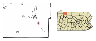
Fairview is a borough in Butler County, Pennsylvania, United States. The population was 198 at the 2010 census. It should not be confused with Fairview in Erie County, which carries the ZIP code 16415.

<span class="mw-page-title-main">Petrolia, Pennsylvania</span> Borough in Pennsylvania, United States

Petrolia is a borough in Butler County, Pennsylvania, United States. The population was 212 at the 2010 census.

<span class="mw-page-title-main">Brady Township, Clarion County, Pennsylvania</span> Township in Pennsylvania, United States

Brady Township is a township in Clarion County, Pennsylvania, United States. The population was 75 at the 2020 census, an increase from the figure of 55 tabulated in 2010.

<span class="mw-page-title-main">Clarion Township, Clarion County, Pennsylvania</span> Township in Pennsylvania, United States

Clarion Township is a township in Clarion County, Pennsylvania, United States. The population was 3,645 at the 2020 census, a decrease from the figure of 4,116 tabulated in 2010, which was, in turn, an increase over the total of 3,273 at the 2000 census.

<span class="mw-page-title-main">Hawthorn, Pennsylvania</span> Borough in Pennsylvania, United States

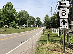
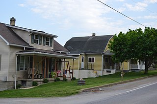
Hawthorn is a borough in Clarion County, Pennsylvania, United States. The population was 482 at the 2020 census.

<span class="mw-page-title-main">Wheatland, Pennsylvania</span> Borough in Pennsylvania, United States

Wheatland is a borough in Mercer County, Pennsylvania, United States, along the Shenango River. The population was 583 at the 2020 census. It is part of the Youngstown-Warren metropolitan area.

<span class="mw-page-title-main">Lanesboro, Pennsylvania</span> Borough in Pennsylvania, United States

Lanesboro is a borough in Susquehanna County, Pennsylvania, United States. The population was 485 at the 2020 census.

<span class="mw-page-title-main">Clintonville, Pennsylvania</span> Borough in Pennsylvania, United States

Clintonville is a borough in Venango County, Pennsylvania, United States. The population was 437 at the 2020 census.

<span class="mw-page-title-main">Rouseville, Pennsylvania</span> Borough in Pennsylvania, United States

Rouseville is a borough in Venango County, Pennsylvania, United States. The population was 456 at the 2020 census.

<span class="mw-page-title-main">Sugarcreek, Pennsylvania</span> Borough in Pennsylvania, United States

Sugarcreek is a borough in Venango County, Pennsylvania, United States. The population was 4,824 at the 2020 census. It is the largest borough by total area in all Venango County.

<span class="mw-page-title-main">Utica, Pennsylvania</span> Borough in Pennsylvania, United States

Utica is a borough that is located in Venango County, Pennsylvania, United States. The population was 184 at the time of the 2020 census.

<span class="mw-page-title-main">Clarendon, Pennsylvania</span> Borough in Pennsylvania, United States

Clarendon is a borough in Warren County, Pennsylvania, United States. The population was 450 at the 2010 census.

<span class="mw-page-title-main">Sugar Grove, Pennsylvania</span> Borough in Pennsylvania, United States

Sugar Grove is a borough in Warren County, Pennsylvania, United States. The population was 614 at the 2010 census.

<span class="mw-page-title-main">Youngsville, Pennsylvania</span> Borough in Pennsylvania, United States

Youngsville is a borough in Warren County, Pennsylvania, United States. The population was 1,729 at the 2010 census.

<span class="mw-page-title-main">Twilight, Pennsylvania</span> Borough in Pennsylvania, United States

Twilight is a borough in Washington County, Pennsylvania, United States. The population was 216 at the 2020 census.

<span class="mw-page-title-main">Madison, Pennsylvania</span> Borough in Pennsylvania, United States

Madison is a borough in Westmoreland County, Pennsylvania, United States. The population was 397 at the 2010 census. The borough was named for James Madison, fourth President of the United States.

<span class="mw-page-title-main">Sutersville, Pennsylvania</span> Borough in Pennsylvania, United States

Sutersville is a borough in Westmoreland County, Pennsylvania, United States. The population was 605 at the 2010 census.

<span class="mw-page-title-main">Tiverton (CDP), Rhode Island</span> CDP in Rhode Island, United States

Tiverton is a census-designated place (CDP) in Newport County, Rhode Island, United States. The CDP encompasses the town center of Tiverton and the adjacent village of North Tiverton. The population of the CDP was 7,557 at the 2010 census.

References

  1. "ArcGIS REST Services Directory". United States Census Bureau. Retrieved October 12, 2022.
  2. 1 2 "Census Population API". United States Census Bureau. Retrieved Oct 12, 2022.
  3. 1 2 Bureau, US Census. "City and Town Population Totals: 2020-2021". Census.gov. US Census Bureau. Retrieved 17 July 2022.
  4. "US Gazetteer files: 2010, 2000, and 1990". United States Census Bureau. 2011-02-12. Retrieved 2011-04-23.
  5. "Census of Population and Housing". U.S. Census Bureau. Retrieved 11 December 2013.
  6. 1 2 "U.S. Census website". United States Census Bureau . Retrieved 2008-01-31.
  7. "Incorporated Places and Minor Civil Divisions Datasets: Subcounty Resident Population Estimates: April 1, 2010 to July 1, 2012". Population Estimates. U.S. Census Bureau. Archived from the original on June 11, 2013. Retrieved 11 December 2013.
  8. "Census of Population and Housing". Census.gov. Retrieved June 4, 2016.