Bathythermograph

Last updated

A bathythermograph Bathythermograph.jpg
A bathythermograph

The bathythermograph, or BT, also known as the Mechanical Bathythermograph, or MBT; [1] is a device that holds a temperature sensor and a transducer to detect changes in water temperature versus depth down to a depth of approximately 285 meters (935 feet). Lowered by a small winch on the ship into the water, the BT records pressure and temperature changes on a coated glass slide as it is dropped nearly freely through the water. [2] While the instrument is being dropped, the wire is paid out until it reaches a predetermined depth, then a brake is applied and the BT is drawn back to the surface. [1] Because the pressure is a function of depth (see Pascal's law), temperature measurements can be correlated with the depth at which they are recorded.[ citation needed ]

Contents

History

The true origins of the BT began in 1935 when Carl-Gustaf Rossby started experimenting. He then forwarded the development of the BT to his graduate student Athelstan Spilhaus, who then fully developed the BT in 1938 [1] as a collaboration between MIT, Woods Hole Oceanographic Institution (WHOI), and the U.S. Navy. [3] The device was modified during World War II to gather information on the varying temperature of the ocean for the U.S. Navy. Originally the slides were prepared "by rubbing a bit of skunk oil on with a finger and then wiping off with the soft side of one's hand," followed by smoking the slide over the flame of a Bunsen burner. [4] Later on the skunk oil was replaced with an evaporated metal film. [1]

Since water temperature may vary by layer and may affect sonar by producing inaccurate location results, bathothermographs (U.S. World War II spelling) were installed on the outer hulls of U.S. submarines during World War II. [5]

By monitoring variances, or lack of variances, in underwater temperature or pressure layers, while submerged, the submarine commander could adjust and compensate for temperature layers that could affect sonar accuracy. This was especially important when firing torpedoes at a target based strictly on a sonar fix. [5]

More importantly, when the submarine was under attack by a surface vessel using sonar, the information from the bathothermograph allowed the submarine commander to seek thermoclines, which are colder layers of water, that would distort the pinging from the surface vessel's sonar, allowing the submarine under attack to "disguise" its actual position and to escape depth charge damage and eventually to escape from the surface vessel. [5]

Throughout the use of the bathythermograph various technicians, watchstanders, and oceanographers noted how dangerous the deployment and retrieval of the BT was. According to watchstander Edward S. Barr:

"… In any kind of rough weather, this BT position was frequently subject to waves making a clean sweep of the deck. In spite of breaking waves over the side, the operator had to hold his station, because the equipment was already over the side. One couldn't run for shelter as the brake and hoisting power were combined in a single hand lever. To let go of this lever would cause all the wire on the winch to unwind, sending the recording device and all its cable to the ocean bottom forever. It was not at all uncommon, from the protective position of the laboratory door, to look back and see your watchmate at the BT winch completely disappear from sight as a wave would come crashing over the side. … We also took turns taking BT readings. It wasn't fair for only one person to get wet consistently." [6]

Expendable bathythermograph

After witnessing firsthand the dangers of deploying and retrieving BTs, James M. Snodgrass began developing the expendable bathythermograph (XBT). Snodgrass' description of the XBT:

Briefly, the unit would break down in two components, as follows: the ship to surface unit, and surface to expendable unit. I have in mind a package which could be jettisoned, either by the "Armstrong" method, or some simple mechanical device, which would at all times be connected to the surface vessel. The wire would be paid out from the surface ship and not from the surface float unit. The surface float would require a minimum of flotation and a small, very simple sea anchor. From this simple platform the expendable BT unit would sink as outlined for the acoustic unit. However, it would unwind as it goes a very fine thread of probably neutrally buoyant conductor terminating at the float unit, thence connected to the wire leading to the ship. [7]

In the early 1960s the U.S. Navy contracted Sippican Corporation of Marion, Massachusetts to develop the XBT, who became the sole supplier. [1]

An XBT being launched via a handheld launcher. Launching-an-expendable-bathythermograph-XBT.jpg
An XBT being launched via a handheld launcher.
A rendering of an XBT probe. Rendering-of-XBT-Expendable-Bathythermograph.png
A rendering of an XBT probe.

The unit is composed of a probe; a wire link; and a shipboard canister. Inside of the probe is a thermistor which is connected electronically to a chart recorder. The probe falls freely at 20 feet per second and that determines its depth and provides a temperature-depth trace on the recorder. A pair of fine copper wires which pay out from both a spool retained on the ship and one dropped with the instrument, provide a data transfer line to the ship for shipboard recording. Eventually, the wire runs out and breaks, and the XBT sinks to the ocean floor. Since the deployment of an XBT does not require the ship to slow down or otherwise interfere with normal operations, XBT's are often deployed from vessels of opportunity , such as cargo ships or ferries, and also by dedicated research ships conducting underway operations when a CTD cast would require stopping the ship for several hours. Airborne versions (AXBT) are also used; these use radio frequencies to transmit the data to the aircraft during deployment. Today Lockheed Martin Sippican has manufactured over 5 million XBTs.

Types of XBTs

Source: [8]

ModelApplicationsMaximum DepthRated Ship SpeedVertical Resolution
T-4Standard probe used by the U.S. Navy for ASW operations460 m
1500 ft
30 knots65 cm
T-5Deep ocean scientific and military applications1830 m
6000 ft
6 knots65 cm
Fast DeepProvides maximum depth capabilities at the highest possible ship speed of any XBT1000 m
3280 ft
20 knots65 cm
T-6Oceanographic applications460 m
1500 ft
15 knots65 cm
T-7Increased depth for improved sonar prediction in ASW and other military applications760 m
2500 ft
15 knots65 cm
Deep BlueIncreased launch speed for oceanographic and naval applications760 m
2500 ft
20 knots65 cm
T-10Commercial fisheries applications200 m
600 ft
10 knots65 cm
T-11High resolution for U.S. Navy mine counter-measures and physical oceanographic applications.460 m
1500 ft
6 knots18 cm

Participation by Month of Country and Institutions deploying XBTs

Below is the list of XBT deployments for 2013: [9]

Cntry/MonthJANFEBMARAPRMAYJUNJULAUGSEPOCTNOVDECTotal
AUS2332922412773113972783133162082322623360
AUS/SIO97590055100052010555182705
BRA046035048046048540268
CAN165332387313014610510725440769
FRA2422589347713017620512061140
GER3821000000000059
ITA290543827300040162629289
JPN5825415781947411534679937782
USA/AOML47747777328123415596344564362353965598
USA/SIO788876072403505911723003825251044774623
ZA84144000000002684338
USA/Others00000012391000061
Total182212462006780175618021542161113101477887175317992

XBT Fall Rate Bias

Since XBTs do not measure depth (e.g. via pressure), fall-rate equations are used to derive depth profiles from what is essentially a time series. The fall rate equation takes the form:

where, z(t) is the depth of the XBT in meters; t is time; and a & b are coefficients determined using theoretical and empirical methods. The coefficient b can be thought of as the initial speed as the probe hits the water. The coefficient a can be thought of as the reduction in mass with time as the wire spools off.

For a considerable time, these equations were relatively well-established, however in 2007 Gouretski and Koltermann showed a bias between XBT temperature measurements and CTD temperature measurements. [10] They also showed that this varies over time and could be due to both errors in the calculation of depth and in measurement of the temperature. From that the 2008 NOAA XBT Fall Rate Workshop [11] began to address the problem, with no viable conclusion as to how to proceed with adjusting the measurements. In 2010 the second XBT Fall Rate Workshop was held in Hamburg, Germany to continue discussing the problem and forge a way forward. [12]

A major implication of this is that a depth-temperature profile can be integrated to estimate upper ocean heat content; the bias in these equations lead to a warm bias in the heat content estimations. The introduction of Argo floats has provided a much more reliable source of temperature profiles than XBTs, however the XBT record remains important for estimating decadal trends and variability and hence much effort has been put into resolving these systematic biases. XBT correction needs to include both a drop-rate correction and a temperature correction.

Uses

See also

Related Research Articles

<span class="mw-page-title-main">Challenger Deep</span> Deepest-known point of Earths seabed

The Challenger Deep is the deepest known point of the seabed of Earth, located in the western Pacific Ocean at the southern end of the Mariana Trench, in the ocean territory of the Federated States of Micronesia. According to the GEBCO Gazetteer of Undersea Feature Names the depression's depth is 10,920 ± 10 m (35,827 ± 33 ft) at 11°22.4′N142°35.5′E, although its exact geodetic location remains inconclusive and its depth has been measured at 10,902–10,929 m (35,768–35,856 ft) by deep-diving submersibles, remotely operated underwater vehicles, benthic landers, and sonar bathymetry. The differences in depth estimates and their geodetic positions are scientifically explainable by the difficulty of researching such deep locations.

<span class="mw-page-title-main">Echo sounding</span> Measuring the depth of water by transmitting sound waves into water and timing the return

Echo sounding or depth sounding is the use of sonar for ranging, normally to determine the depth of water (bathymetry). It involves transmitting acoustic waves into water and recording the time interval between emission and return of a pulse; the resulting time of flight, along with knowledge of the speed of sound in water, allows determining the distance between sonar and target. This information is then typically used for navigation purposes or in order to obtain depths for charting purposes.

<span class="mw-page-title-main">Thermocline</span> Thermal layer in a body of water

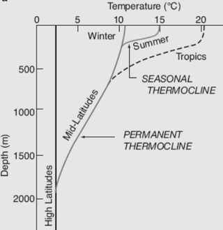
A thermocline is a distinct layer based on temperature within a large body of fluid with a high gradient of distinct temperature differences associated with depth. In the ocean, the thermocline divides the upper mixed layer from the calm deep water below.

<span class="mw-page-title-main">Sea surface temperature</span> Water temperature close to the oceans surface

Sea surface temperature (SST), or ocean surface temperature, is the ocean temperature close to the surface. The exact meaning of surface varies in the literature and in practice. It is usually between 1 millimetre (0.04 in) and 20 metres (70 ft) below the sea surface. Sea surface temperatures greatly modify air masses in the Earth's atmosphere within a short distance of the shore. Local areas of heavy snow can form in bands downwind of warm water bodies within an otherwise cold air mass. Warm sea surface temperatures can develop and strengthen cyclones over the Ocean. Experts call this process tropical cyclogenesis. Tropical cyclones can also cause a cool wake. This is due to turbulent mixing of the upper 30 metres (100 ft) of the ocean. Sea surface temperature changes during the day. This is like the air above it, but to a lesser degree. There is less variation in sea surface temperature on breezy days than on calm days. Ocean currents, such as the Atlantic Multidecadal Oscillation, can affect sea surface temperatures over several decades. Thermohaline circulation has a major impact on average sea surface temperature throughout most of the world's oceans.

The World Ocean Database Project, or WOD, is a project established by the Intergovernmental Oceanographic Commission (IOC). The project leader is Sydney Levitus who is director of the International Council for Science (ICSU) World Data Center (WDC) for Oceanography, Silver Spring. In recognition of the success of the IOC Global Oceanographic Data Archaeological and Rescue Project, a proposal was presented at the 16th Session of the Committee on International Oceanographic Data and Information Exchange (IODE), which was held in Lisbon, Portugal, in October–November 2000, to establish the World Ocean Database Project. This project is intended to stimulate international exchange of modern oceanographic data and encourage the development of regional oceanographic databases as well as the implementation of regional quality control procedures. This new Project was endorsed by the IODE at the conclusion of the Portugal meeting, and the IOC subsequently approved this project in June 2001.

<span class="mw-page-title-main">Sonobuoy</span> Expendable sonar system dropped/ejected from aircraft or ships

A sonobuoy is a small expendable sonar buoy dropped from aircraft or ships for anti-submarine warfare or underwater acoustic research. Sonobuoys are typically around 13 cm (5 in) in diameter and 91 cm (3 ft) long. When floating on the water, sonobuoys have both a radio transmitter above the surface and hydrophone sensors underwater.

<span class="mw-page-title-main">Survey vessel</span> Type of research vessel

A survey vessel is any type of ship or boat that is used for underwater surveys, usually to collect data for mapping or planning underwater construction or mineral extraction. It is a type of research vessel, and may be designed for the purpose, modified for the purpose or temporarily put into the service as a vessel of opportunity, and may be crewed, remotely operated, or autonomous. The size and equipment vary to suit the task and availability.

<span class="mw-page-title-main">Argo (oceanography)</span> International oceanographic observation program

Argo is an international programme for researching the ocean. It uses profiling floats to observe temperature, salinity and currents. Recently it has observed bio-optical properties in the Earth's oceans. It has been operating since the early 2000s. The real-time data it provides support climate and oceanographic research. A special research interest is to quantify the ocean heat content (OHC). The Argo fleet consists of almost 4000 drifting "Argo floats" deployed worldwide. Each float weighs 20–30 kg. In most cases probes drift at a depth of 1000 metres. Experts call this the parking depth. Every 10 days, by changing their buoyancy, they dive to a depth of 2000 metres and then move to the sea-surface. As they move they measure conductivity and temperature profiles as well as pressure. Scientists calculate salinity and density from these measurements. Seawater density is important in determining large-scale motions in the ocean.

RV <i>Roger Revelle</i>

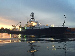
R/V Roger Revelle is a Thomas G. Thompson-class oceanographic research ship operated by Scripps Institution of Oceanography under charter agreement with Office of Naval Research as part of the University-National Oceanographic Laboratory System (UNOLS) fleet. The ship is named after Roger Randall Dougan Revelle, who was essential to the incorporation of Scripps into the University of California San Diego.

The World Ocean Circulation Experiment (WOCE) was a component of the international World Climate Research Program, and aimed to establish the role of the World Ocean in the Earth's climate system. WOCE's field phase ran between 1990 and 1998, and was followed by an analysis and modeling phase that ran until 2002. When the WOCE was conceived, there were three main motivations for its creation. The first of these is the inadequate coverage of the World Ocean, specifically in the Southern Hemisphere. Data was also much more sparse during the winter months than the summer months, and there was—and still is to some extent—a critical need for data covering all seasons. Secondly, the data that did exist was not initially collected for studying ocean circulation and was not well suited for model comparison. Lastly, there were concerns involving the accuracy and reliability of some measurements. The WOCE was meant to address these problems by providing new data collected in ways designed to "meet the needs of global circulation models for climate prediction."

<span class="mw-page-title-main">Underwater acoustics</span> Study of the propagation of sound in water

Underwater acoustics is the study of the propagation of sound in water and the interaction of the mechanical waves that constitute sound with the water, its contents and its boundaries. The water may be in the ocean, a lake, a river or a tank. Typical frequencies associated with underwater acoustics are between 10 Hz and 1 MHz. The propagation of sound in the ocean at frequencies lower than 10 Hz is usually not possible without penetrating deep into the seabed, whereas frequencies above 1 MHz are rarely used because they are absorbed very quickly.

Geophysical MASINT is a branch of Measurement and Signature Intelligence (MASINT) that involves phenomena transmitted through the earth and manmade structures including emitted or reflected sounds, pressure waves, vibrations, and magnetic field or ionosphere disturbances.

<span class="mw-page-title-main">CTD (instrument)</span> Device to measure seawater properties

CTD stands for conductivity, temperature, and depth. A CTD instrument is an oceanography sonde used to measure the electrical conductivity, temperature, and pressure of seawater. The pressure is closely related to depth. Conductivity is used to determine salinity.

<span class="mw-page-title-main">Sentry (AUV)</span> Autonomous underwater vehicle made by Woods Hole Oceanographic institution

The Sentry is an autonomous underwater vehicle (AUV) made by the Woods Hole Oceanographic Institution. Sentry is designed to descend to depths of 6,000 metres (20,000 ft) and to carry a range of devices for taking samples, pictures and readings from the deep sea.

A sound velocity probe is a device that is used for measuring the speed of sound, specifically in the water column, for oceanographic and hydrographic research purposes.

<span class="mw-page-title-main">Ocean temperature</span> Physical quantity that expresses hot and cold in ocean water

Several factors cause the ocean temperature to vary. These are depth, geographical location and season. Both the temperature and salinity of ocean water differ. Warm surface water is generally saltier than the cooler deep or polar waters. In polar regions, the upper layers of ocean water are cold and fresh. Deep ocean water is cold, salty water found deep below the surface of Earth's oceans. This water has a uniform temperature of around 0-3 °C. The ocean temperature also depends on the amount of solar radiation falling on its surface. In the tropics, with the Sun nearly overhead, the temperature of the surface layers can rise to over 30 °C (86 °F). Near the poles the temperature in equilibrium with the sea ice is about −2 °C (28 °F). There is a continuous circulation of water in the oceans. Thermohaline circulation (THC) is part of the large-scale ocean circulation. It is driven by global density gradients created by surface heat and freshwater fluxes. Warm surface currents cool as they move away from the tropics. This happens as the water becomes denser and sinks. Changes in temperature and density move the cold water back towards the equator as a deep sea current. Then it eventually wells up again towards the surface.

EV <i>Nautilus</i> Research vessel

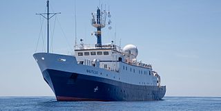
EVNautilus is a 68-meter (223 ft) research vessel owned by the Ocean Exploration Trust under the direction of Robert Ballard, the researcher known for finding the wreck of the Titanic and the German battleship Bismarck. The vessel's home port is at the AltaSea facility in San Pedro in the Port of Los Angeles, California. Nautilus is equipped with a team of remotely operated vehicles (ROVs), Hercules, Argus, Little Hercules, and Atalanta, a multibeam mapping system, and mapping tools Diana and Echo, allowing it to conduct deep sea exploration of the ocean to a depth of 4,000 meters (13,000 ft).

<span class="mw-page-title-main">Rosette sampler</span> Device for deep-water water sampling

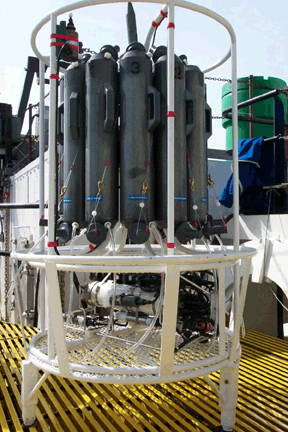
A rosette sampler is a device used for water sampling in deep water. Rosette samplers are used in the ocean and large inland water bodies such as the North American Great Lakes in order to investigate quality. Rosette samplers are a key piece of equipment in oceanography and have been used to collect information over many years in repeat hydrographic surveys.

Ninfe-class research vessel

The Ninfe class of survey vessels consists of two catamaran hulls operated by the Marina Militare Italiana.

USSP is a planned Submarine rescue ship of the Marina Militare, financed with 2017's balance law.
It is expected to replace Italian ship Anteo.

References

  1. 1 2 3 4 5 Scripps Institution of Oceanography: Probing the Oceans 1936 to 1976. San Diego, Calif: Tofua Press, 1978. http://ark.cdlib.org/ark:/13030/kt109nc2cj/
  2. Stewart, Robert H. (2007). Introduction to Physical Oceanography (PDF). College Station: Texas A&M University. OCLC   169907785.
  3. "Bathythermograph, Athelstan Spilhaus, 1936 | the MIT 150 Exhibition".[ permanent dead link ]
  4. Letter from Allyn Vine to Richard H. Fleming, 20 August 1941.
  5. 1 2 3 Blair, Jr., Clay (2001). Silent Victory, the U.S. Submarine war against Japan. Annapolis, Maryland: Naval Institute Press. p. 458. ISBN   1-55750-217-X.
  6. "MIDPAC — The First Big Step," manuscript, 17 August 1975.
  7. "New Techniques in Undersea Technology," IEEE Transactions on Aerospace and Electronic Systems, Vol. AES-2, No. 6 (November 1966), 626.
  8. Lockheed Martin Sippican (September 2005). "Expendable Bathythermograph Expendable Sound Velocimeter (XBT/XSV) Expendable Profiling Systems" (PDF). p. 3. Archived from the original (PDF) on 3 February 2013. Retrieved 2015-07-20.
  9. "SOOP Operations Report: XBT Program" (PDF). Atlantic Oceanographic & Meteorological Laboratory of NOAA. 31 October 2014. p. 2. Retrieved 20 July 2015.
  10. Gouretski, V. V., and K. P. Koltermann, 2007, How much is the ocean really warming? Geophysical Research Letters, L01610, doi:10.1029/2006GL027834
  11. "NOAA XBT Fall Rate Workshop" . Retrieved 3 December 2013.
  12. Viktor Gouretsk (25–27 August 2010). XBT Bias and Fall Rate Workshop Summary Report (PDF). XBT Bias and Fall Rate workshop. Hamburg, Germany. p. 14. Archived from the original (PDF) on 3 July 2013. Retrieved 8 May 2014.
  13. Helicopter-Based Ocean Observations Capture Broad Ocean Heat Intrusions Toward the Totten Ice Shelf, Yoshihiro Nakayama et al, AGU, 2023-09-11
  14. Antarctic helicopter mission helps confirm Totten Glacier melting from below due to warm water, Clancy Balen, ABC News Online, 2023-09-13