Battle Mountain (Virginia)

Last updated

Battle Mountain
Western slope Battle Mountain.jpg
The western slope of Battle Mountain, Castleton, Virginia
Highest point
Elevation 1,162 ft (354 m)
Prominence 762 ft (232 m)
Coordinates 38°39′26″N78°3′36″W / 38.65722°N 78.06000°W / 38.65722; -78.06000
Geography
Battle Mountain countour map based on NASA ASTER data.jpg
A digital contour plot of Battle Mountain and Little Battle Mountain, based on digital imagery data from the NASA ASTER satellite. Processed by Thomas A. Woolman, PhD (2020), MBA, MS, MS, in 2015.
Location Rappahannock County, Virginia, US
Parent range Blue Ridge Mountains
Topo map USGS Massies Corner, Va.
Geology
Age of rock 704,000,000 years
Mountain type Stratovolcano
Volcanic belt Robertson River Igneous Suite
Last eruption 704 Mya

Battle Mountain is an igneous mountain in Rappahannock County, Virginia. The eastern slope is generally considered to reside in the unincorporated town of Amissville, Virginia while the western slope is generally considered to be within Castleton, Virginia. The entire mountain including the summit lies within private property at an elevation of 1,162 ft (354.2 m). [1]

Contents

Geology

Digital terrain model of the western slopes of Battle Mountain and Little Battle Mountain, generated with data from the NASA ASTER satellite by Woolman (2016). Digital terrain model of Battle Mountain based on ASTER data.png
Digital terrain model of the western slopes of Battle Mountain and Little Battle Mountain, generated with data from the NASA ASTER satellite by Woolman (2016).

Tectonic emplacement and geochronology

It is an extinct volcano dating to the Neoproterozoic and is approximately 704 million years old (+/- 4 million years) as dated using the U-Pb zircon crystal geochronology method. It is a unit of the Robertson River Igneous Suite [2] and is located within the Blue Ridge anticlinorium. This volcanic formation was a result of crustal extensional rifting of the eastern Laurentian margin of the supercontinent Rodinia. [3] This was the beginning of a chain of events that ultimately gave birth to the precursor Atlantic, the Iapetus Ocean at 550 Ma during the EdiacaranCambrian transition. [4]

Geochemical evolution

The volcano is composed of alkali feldspar granitic rock of the Robertson River Igneous Suite. This includes felsic complex material such as biotite, hornblende-biotite, magnetite, and alkali granitic rock including rhyolite on the eastern slopes of Battle Mountain [5] and the adjacent (and geologically related) Little Battle Mountain (elevation 937 feet).

Theorized original appearance of Battle Mountain at 704 million years ago by Woolman (2016). Elevation shown in meters. BattleMountain PaleaogeographicReconstruction 704Mya.jpg
Theorized original appearance of Battle Mountain at 704 million years ago by Woolman (2016). Elevation shown in meters.
A typical large rhyolite outcrop on the eastern slope of Battle Mountain, at an approximate elevation of 850 feet. Emily J. Woolman (aged 4, 2014) is shown for scale. Typical large rhyolite outcrop on the eastern slope of Battle Mountain.jpg
A typical large rhyolite outcrop on the eastern slope of Battle Mountain, at an approximate elevation of 850 feet. Emily J. Woolman (aged 4, 2014) is shown for scale.
The eastern slope of Battle Mountain, image taken approximately three kilometers from the base on Viewtown Road, Amissville, VA. Eastern slope Battle Mountain 1km.jpg
The eastern slope of Battle Mountain, image taken approximately three kilometers from the base on Viewtown Road, Amissville, VA.
A large white quartz boulder near the base of Battle Mountain on Viewtown Road in Amissville, VA. The white coloration is indicative of an extremely high SiO2 gas content from highly viscous rhyolitic lava, generated prior to a theorized (Woolman, T.A., 2016) lateral explosion event which may have occurred at 704 Ma during the Cryogenian period. Large Quartz Boulder from Battle Mountain.jpg
A large white quartz boulder near the base of Battle Mountain on Viewtown Road in Amissville, VA. The white coloration is indicative of an extremely high SiO2 gas content from highly viscous rhyolitic lava, generated prior to a theorized (Woolman, T.A., 2016) lateral explosion event which may have occurred at 704 Ma during the Cryogenian period.
Quartz boulder obtained from the eastern (predominately rhyolite) slope of Battle Mountain, Amissville, Virginia. Rock hammer shown for scale. The reddish-brown mineralization in the quartz is iron (Fe). Quartz boulder obtained from Battle Mountain, Amissville Virginia.png
Quartz boulder obtained from the eastern (predominately rhyolite) slope of Battle Mountain, Amissville, Virginia. Rock hammer shown for scale. The reddish-brown mineralization in the quartz is iron (Fe).

Palaeogeographic reconstruction

A unique geological feature of Battle Mountain is that the western slope outcrops are composed entirely of alkali feldspar granite, while the eastern slope up to and including the summit is entirely rhyolitic. This provides strong evidence of a theorized lateral explosive eruption event centered on the eastern slope at approximately 704 Ma as proposed by Woolman (2016). Further mathematical geology evidence which supports this theory includes a palaeogeographic reconstruction of the mountain by Woolman utilizing artificial neural networks and Markov chain geostatistical models including period climate condition-based soil erosion rates, Kirkby's hillslope movement evolution equations and recursive biogeochemical soil erosion rates in felsic granitic conditions. The result was the digital reconstruction image shown on the left, indicating what Battle Mountain may have looked like 704 million years ago on the western slope.

Battle Mountain (center) from approximately eight miles south, driving north on Eggbornsville Road, Rixeyville, Culpeper County, VA. Battle Mountain from-8-miles-south Culpeper County.jpg
Battle Mountain (center) from approximately eight miles south, driving north on Eggbornsville Road, Rixeyville, Culpeper County, VA.

Only known volcanic mountains in Rappahannock County, VA

Battle Mountain and Little Battle Mountain are the only mountains in Rappahannock County which are known to be volcanic in origin, and are among the oldest visibly intact extinct volcanoes in Virginia. White quartz boulders and smaller fragments are common on and around Battle Mountain, a result of molten silica that was contained in the rhyolite lava and granitic magma that formed the volcano. As quartz is extremely hard relative to feldspar granite and rhyolite, it tends to remain present on the surface while the softer granite it was embedded in wears away into the soil.

Moutains at Amissville.jpg
Panoramic image taken from a drone at an altitude of approximately 200 meters in September, 2014. Facing north, this shows the western side of Battle Mountain and Little Battle Mountain (units of the Robertson River Igneous Suite) on the right. Aaron mountain, composed of sandstone, is visible on the left. The Blue Ridge Mountains of Shenandoah National Park are visible on the horizon. Richmond Road is visible running up through the middle of this image.

Access

The nearest unincorporated town is Amissville, Virginia at approximately 4 miles away. Access to the mountain and the summit must be negotiated with local landowners first as the mountain, including all portions of the July 1863 battlefield exists entirely on private property.

Agriculture

The various slopes of Battle Mountain are in either commercial timber (primarily mixed hardwoods), cattle pasture (western slope) or crops (corn, hay and pumpkins as of 2019). Battle Mountain Farm, which comprises the majority of the eastern slope of Battle Mountain is a mixed hardwood timber and small-scale commercial pumpkin grower, specializing in large jack-o-lantern pumpkins. Their pumpkins are grown without herbicides or pesticides in multiple commercial-scale 60-foot by 5-foot ecologically sustainable raised beds (no soil tilling required) using locally produced natural fertilizers. The beds also utilize water-conserving polymer mulch and irrigation drip lines attached to on-site wells approximately 300 feet deep, providing mineral-rich water from volcanic aquifers. The well water pressure is provided by a 10.4 kilowatt grid-tied solar panel array on the farm, with lead-acid battery backup.

Front of a t-shirt from 2019 used to promote Battle Mountain Farm's pumpkin growing sales operations 2019shirt front.png
Front of a t-shirt from 2019 used to promote Battle Mountain Farm's pumpkin growing sales operations
Back of a t-shirt from 2019 used to promote Battle Mountain Farm's pumpkin growing sales operations 2019shirt back.png
Back of a t-shirt from 2019 used to promote Battle Mountain Farm's pumpkin growing sales operations

Related Research Articles

<span class="mw-page-title-main">Granite</span> Type of igneous rock

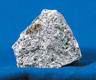
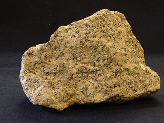
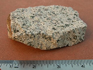
Granite is a coarse-grained (phaneritic) intrusive igneous rock composed mostly of quartz, alkali feldspar, and plagioclase. It forms from magma with a high content of silica and alkali metal oxides that slowly cools and solidifies underground. It is common in the continental crust of Earth, where it is found in igneous intrusions. These range in size from dikes only a few centimeters across to batholiths exposed over hundreds of square kilometers.

<span class="mw-page-title-main">Syenite</span> Intrusive igneous rock

Syenite is a coarse-grained intrusive igneous rock with a general composition similar to that of granite, but deficient in quartz, which, if present at all, occurs in relatively small concentrations. It is considered a granitoid. Some syenites contain larger proportions of mafic components and smaller amounts of felsic material than most granites; those are classed as being of intermediate composition.

<span class="mw-page-title-main">Rhyolite</span> Igneous, volcanic rock, of felsic (silica-rich) composition

Rhyolite is the most silica-rich of volcanic rocks. It is generally glassy or fine-grained (aphanitic) in texture, but may be porphyritic, containing larger mineral crystals (phenocrysts) in an otherwise fine-grained groundmass. The mineral assemblage is predominantly quartz, sanidine, and plagioclase. It is the extrusive equivalent to granite.

<span class="mw-page-title-main">Tonalite</span>

Tonalite is an igneous, plutonic (intrusive) rock, of felsic composition, with phaneritic (coarse-grained) texture. Feldspar is present as plagioclase (typically oligoclase or andesine) with alkali feldspar making up less than 10% of the total feldspar content. Quartz (SiO2) is present as more than 20% of the total quartz-alkali feldspar-plagioclase-feldspathoid (QAPF) content of the rock. Amphiboles and biotite are common accessory minerals.

<span class="mw-page-title-main">Granitoid</span> Category of coarse-grained igneous rocks

A granitoid is a generic term for a diverse category of coarse-grained igneous rocks that consist predominantly of quartz, plagioclase, and alkali feldspar. Granitoids range from plagioclase-rich tonalites to alkali-rich syenites and from quartz-poor monzonites to quartz-rich quartzolites. As only two of the three defining mineral groups need to be present for the rock to be called a granitoid, foid-bearing rocks, which predominantly contain feldspars but no quartz, are also granitoids. The terms granite and granitic rock are often used interchangeably for granitoids; however, granite is just one particular type of granitoid.

<span class="mw-page-title-main">Anahim Volcanic Belt</span> Chain of volcanoes and related magmatic features in British Columbia, Canada

The Anahim Volcanic Belt (AVB) is a west–east trending chain of volcanoes and related magmatic features in British Columbia, Canada. It extends from Athlone Island on the Central Coast, running eastward through the strongly uplifted and deeply dissected Coast Mountains to near the community of Nazko on the Interior Plateau. The AVB is delineated as three west-to-east segments that differ in age and structure. A wide variety of igneous rocks with differing compositions occur throughout these segments, comprising landforms such as volcanic cones, volcanic plugs, lava domes, shield volcanoes and intrusions.

<span class="mw-page-title-main">Wichita Mountains</span> Mountains in the US state Oklahoma

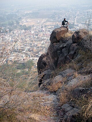
The Wichita Mountains are located in the southwestern portion of the U.S. state of Oklahoma. It is the principal relief system in the Southern Oklahoma Aulacogen, being the result of a failed continental rift. The mountains are a northwest-southeast trending series of rocky promontories, many capped by 500 million-year old granite. These were exposed and rounded by weathering during the Pennsylvanian & Permian Periods. The eastern end of the mountains offers 1,000 feet (305 m) of topographic relief in a region otherwise dominated by gently rolling grasslands.

<span class="mw-page-title-main">Quartz latite</span> Rock composed mostly of alkali feldspar and plagioclase

A quartz latite is a volcanic rock or fine grained extrusive rock composed mostly of alkali feldspar and plagioclase with some quartz. It forms from the rapid cooling of magma of intermediate composition but moderately enriched in alkali metal oxides.

<span class="mw-page-title-main">Grenville orogeny</span> Mesoproterozoic mountain-building event

The Grenville orogeny was a long-lived Mesoproterozoic mountain-building event associated with the assembly of the supercontinent Rodinia. Its record is a prominent orogenic belt which spans a significant portion of the North American continent, from Labrador to Mexico, as well as to Scotland.

<span class="mw-page-title-main">Amissville, Virginia</span> Unincorporated community in Virginia, United States

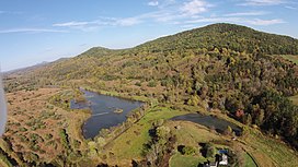
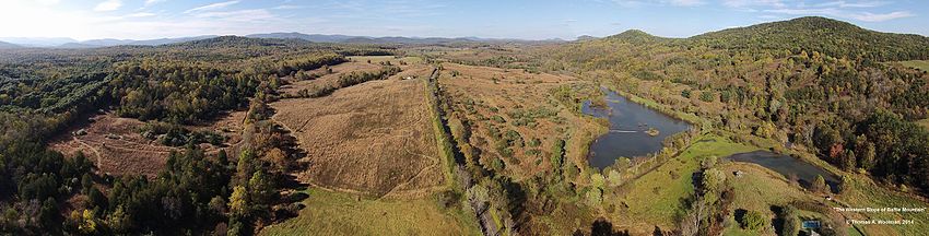
Amissville is an unincorporated community in Rappahannock County in the U.S. commonwealth of Virginia. It is located on U.S. Route 211 about halfway between Warrenton and the small town of Washington, Virginia.

<span class="mw-page-title-main">Monzonite</span> Igneous intrusive rock with low quartz and equal plagioclase and alkali feldspar

Monzonite is an igneous intrusive rock, formed by slow cooling of underground magma that has a moderate silica content and is enriched in alkali metal oxides. Monzonite is composed mostly of plagioclase and alkali feldspar.

The Mount Pleasant Caldera is a large eroded Late Devonian volcanic caldera complex, located in the northern Appalachian Mountains of southwestern New Brunswick, Canada. It is one of few noticeable pre-Cenozoic calderas, and its formation is associated to a period of crustal thinning that followed the Acadian orogeny in the northern Appalachian Mountains. It sits relatively near to the coastline.

<span class="mw-page-title-main">Igneous rock</span> Rock formed through the cooling and solidification of magma or lava

Igneous rock, or magmatic rock, is one of the three main rock types, the others being sedimentary and metamorphic. Igneous rocks are formed through the cooling and solidification of magma or lava.

The Cymru Terrane is one of five inferred fault bounded terranes that make up the basement rocks of the southern United Kingdom. The other notable geological terranes are the Charnwood Terrane, Fenland Terrane, Wrekin Terrane and the Monian Composite Terrane. In this article the definition of terrane is that implying rocks associated with the composition of the Precambrian basement. The Cymru Terrane is bounded to the northwest by the Menai Strait Fault System and to the southeast by the Pontesford Lineament. The geological terrane to the west is the Monian Composite Terrane and to the east is Wrekin Terrane. The majority of rocks in the area are associated with the outcrops that are evident at the faulted boundaries.

<span class="mw-page-title-main">Southern Oklahoma Aulacogen</span> Failed rift in the western and southern US of the triple junction that became the Iapetus Ocean

The Southern Oklahoma Aulacogen(ah-lah-coh-jin)  is a failed rift, or failed rift arm (aulacogen), of the triple junction that became the Iapetus Ocean spreading ridges. It is a significant geological feature in the Western and Southern United States. It formed sometime in the early to mid Cambrian Period and spans the Wichita Mountains, Taovayan Valley, Anadarko Basin, and Hardeman Basin in Southwestern Oklahoma. The Southern Oklahoma Aulacogen is primarily composed of basaltic dikes, gabbros, and units of granitic rock.

<span class="mw-page-title-main">Tosham Hill range</span>

Tosham hill range, located at and in the area around Tosham, with an average elevation of 207 meters, and the rocks exposed in and around Tosham hills are part of subsurface north-western spur of Alwar group of Delhi supergroup of Aravalli Mountain Range, belong to the Precambrian Malani igneous suite of rocks and have been dated at 732 Ma BP. This range in Aravalli Craton is a remnant of the outer ring of a fallen chamber of an extinct volcano. Tosham hill range covers the hills at Tosham, Khanak, and Riwasa as well as the small rocky outcrops at Nigana, Dulehri, Dharan, Dadam, and Kharkari Makhwan. Among these, Khanak hill is the largest in area and tallest in height.

The geology of Virginia began to form 1.8 billion years ago and potentially even earlier. The oldest rocks in the state were metamorphosed during the Grenville orogeny, a mountain building event beginning 1.2 billion years ago in the Proterozoic, which obscured older rocks. Throughout the Proterozoic and Paleozoic, Virginia experienced igneous intrusions, carbonate and sandstone deposition, and a series of other mountain building events which defined the terrain of the inland parts of the state. The closing of the Iapetus Ocean, to form the supercontinent Pangaea added additional small landmasses, some of which are now hidden beneath thick Atlantic Coastal Plain sediments. The region subsequently experienced the rifting open of the Atlantic Ocean in the Mesozoic, the development of the Coastal Plain, isolated volcanism and a series of marine transgressions that flooded much of the area. Virginia has extensive coal, deposits of oil and natural gas, as well as deposits of other minerals and metals, including vermiculite, kyanite and uranium.

<span class="mw-page-title-main">Archean felsic volcanic rocks</span> Felsic volcanic rocks formed in the Archean Eon

Archean felsic volcanic rocks are felsic volcanic rocks that were formed in the Archean Eon. The term "felsic" means that the rocks have silica content of 62–78%. Given that the Earth formed at ~4.5 billion year ago, Archean felsic volcanic rocks provide clues on the Earth's first volcanic activities on the Earth's surface started 500 million years after the Earth's formation.

The geology of South Georgia and the South Sandwich Islands is part of the largely submerged Scotia Ridge. The island of South Georgia is unusual among oceanic islands for having pre-Cretaceous sedimentary rocks underlying much of the island and a significant portion of felsic igneous rocks. Two-thirds of the island consists of intensely folded flysch, capped with Aptian age fossils, tuff and greywacke in the Cumberland Bay Series. The series includes slate, phyllite, conglomerate, siltstone and sandstone. In the west are basalt flows, pillowed spilite, prehnite and trachyandesite, as well as shale with radiolarite fossils.

References

  1. "Robertson River Igneous Suite; Battle Mountain Alkali Feldspar Granite – felsite". usgs.gov. Retrieved August 21, 2016.
  2. Richard P. Tollo and Sara Arav (1992). "The Robertson River Igneous Suite (Blue Ridge Province, Virginia) — Late Proterozoic anorogenic (A-type) granitoids of unique petrochemical affinity". The Robertson River Igneous Suite (Blue Ridge Province, Virginia)—Late Proterozoic anorogenic (A-type) granitoids of unique petrochemical affinity. Basement Tectonics 8 (pp. 425–441). Proceedings of the International Conferences on Basement Tectonics. Vol. 2. Springer Netherlands. pp. 425–441. doi:10.1007/978-94-011-1614-5_29. ISBN   978-94-010-4703-6.
  3. Richard P. Tollo, John N. Aleinikoff (November 1, 1996). "Petrology and U-PB geochronology of the Robertson River Igneous Suite, Blue Ridge province, Virginia – Evidence for multistage magmatism associated with an early episode of Laurentian rifting". American Journal of Science. 296 (9): 1045–1090. doi: 10.2475/ajs.296.9.1045 . Retrieved August 22, 2016.
  4. Birthdate for the lapetus Ocean? A precise U-Pb zircon and baddeleyite age for the Long Range dikes, southeast Labrador
  5. Thomas A. Woolman (April 1, 2016). "A Gallium Anomaly Utilized in Palaeogeographic Reconstruction of Battle Mountain, Rappahannock County, Virginia". Transactions of the Kansas Academy of Science. 119 (2): 155–172. doi:10.1660/062.119.0206. S2CID   88195835.