
The Battle of Almansa took place on 25 April 1707, during the War of the Spanish Succession. It was fought between an army loyal to Philip V of Spain, Bourbon claimant to the Spanish throne, and one supporting his Habsburg rival, Archduke Charles of Austria. The result was a decisive Bourbon victory that reclaimed most of eastern Spain for Philip.

Albacete is a province of central Spain, in the southern part of the autonomous community of Castile–La Mancha. As of 2012, Albacete had a population of 402,837 people. Its capital city, also called Albacete, is 262 kilometres (163 mi) by road southeast of Madrid.

Elche is a city and municipality of Spain, belonging to the province of Alicante, in the Valencian Community. According to 2014 data, Elche has a population of 228,647 inhabitants, making it the third most populated municipality in the region and the 20th largest Spanish municipality. It is part of the comarca of Baix Vinalopó.
Lorca is a municipality and city in the autonomous community of the Region of Murcia in south-eastern Spain, 58 kilometres (36 mi) southwest of the city of Murcia. The municipality had a population of 95,515 in 2020, up from the 2001 census total of 77,477. Lorca is the municipality with the second largest surface area in Spain, 1,675.21 km2 (646.80 sq mi), after Cáceres. The city is home to Lorca Castle and the Collegiate church dedicated to St. Patrick.

Francisco Salzillo y Alcaraz was a Spanish sculptor. He is the most representative Spanish image-maker of the 18th century and one of greatest of the Baroque. Francisco Salzillo worked exclusively on religious themes, and almost always in polychromed wood. He made hundreds of pieces that are distributed throughout the Region of Murcia and some in bordering provinces. The Spanish Civil War (1936–1939) caused the destruction of many of the works of Salzillo. Some of his masterpieces include his nonprocessional religious work, his processional work, and his great Nativity scene.

The Battle of Uclés was fought on 29 May 1108 during the Reconquista period near Uclés just south of the river Tagus between the Christian forces of Castile and León under Alfonso VI and the forces of the Muslim Almoravids under Tamim ibn-Yusuf. The battle was a disaster for the Christians and many of the high nobility of León, including seven counts, died in the fray or were beheaded afterwards, while the heir-apparent, Sancho Alfónsez, was murdered by villagers while trying to flee. Despite this, the Almoravids could not capitalise on their success in the open field by taking Toledo.

La Manga, or La Manga del Mar Menor is a seaside spit of Mar Menor in the Region of Murcia, Spain.
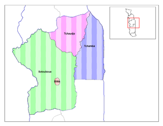
Tchaoudjo is a prefecture located in the Centrale Region of Togo. The capital city is Sokodé. At the time of the 2022 census it had a population of 240,360 people.
Huerto is a municipality located in the Monegros comarca, province of Huesca, Aragon, Spain. According to the 2004 census (INE), the municipality has a population of 253 inhabitants.

Las Torres de Cotillas is a Spanish municipality in the autonomous community of Murcia and is located in the eastern half.

Alhama de Murcia is a Spanish municipality in the autonomous community of the Region of Murcia. It is located in the north of the southern half of the region. The municipality shares borders with Librilla in its north, Murcia in its northeast, Fuente Álamo de Murcia in its east, Mazarrón in its south, Totana in its west and Mula in its northwest.

Cape Palos is a cape in the Spanish municipality of Cartagena, in the region of Murcia. It is part of a small range of volcanic mounts that form a small peninsula. The Mediterranean islands of Grosa and the group known as the Hormigas Islands are part of this range, as well as the islands in the Mar Menor. The name Palos is derived from the Latin word palus, meaning ‘lagoon’, a reference to the Mar Menor.
Las Palas is a village, situated in the autonomous region of Murcia in South East Spain. The name Las Palas is derived from the large amount of "Palas" (cactus) found in the area. The village has been in existence since the 16th Century. It is located 7 km south of Fuente Álamo de Murcia and 20 km north west of Cartagena.
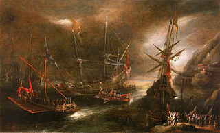
The Battle of Cartagena was a naval battle fought on 3 September 1643, during the Thirty Years' War off Cabo de Gata near Cartagena, Spain.
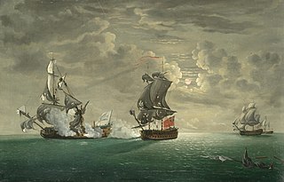
The Battle of Cartagena took place on 28 February 1758 off the Spanish port of Cartagena during the Seven Years' War. A British fleet under Henry Osborn, which had blockaded a French fleet in Cartagena, attacked and defeated a French force under Michel-Ange Duquesne de Menneville coming to their assistance.

Lorca-Sutullena railway station is a station in Lorca, Spain. It was damaged in the 2011 Lorca earthquake.
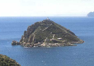
Escombreras is an islet at the mouth of Cartagena's port, in Spain's Region of Murcia. Since 2011 a breakwater built for the expansion of Cartagena's port hooks around the north side of the island, but does not connect to it.

The Battle of El Albujón was a confrontation between Bourbon troops under commandante Patricio Moran and corporal José Hernández and an English force backed by troops loyal to Charles VI. It took place on 21 September 1706 and formed part of the War of the Spanish Succession. It took part in the El Albujón district of the Spanish town of Cartagena and ended in a Bourbon victory. With the victory at the battle of Murcia, it led to the reconquest of Cartagena and evidenced the failure of the Austrian campaign in the kingdom of Murcia, a region of Castile.

Calblanque Regional Park, Monte de las Cenizas y Peña del Águila is a regional park in the south-east of Spain, and in this country in the autonomous community Región de Murcia. In this region, it is located in the municipalities Cartagena and La Unión. It is part of Sierra Minera, a mountain chain in the Baetic System.

The National Museum of Subaquatic Archaeology is a underwater archaeology museum in Cartagena (Murcia), Spain. It owns a large collection of pieces recovered from shipwrecks that begins in the Phoenician period, and arrives until the 19th century. It is one of the National Museums of Spain and it is attached to the Ministry of Culture.
