Bayou Corne sinkhole

Last updated
Bayou Corne sinkhole
Pic from the canoe on Bayou Corne.jpg
2010 view of Bayou Corne
USA Louisiana relief location map.svg
Red pog.svg
Bayou Corne sinkhole
Location Assumption Parish, Louisiana
Coordinates 30°0′40″N91°8′35″W / 30.01111°N 91.14306°W / 30.01111; -91.14306
First floodedAugust 3, 2012 (2012-08-03)
Surface area37 acres (15 ha)
Max. depthat least 750 ft (230 m)

The Bayou Corne sinkhole (French : Doline de Bayou Corne) was created from a collapsed underground salt dome cavern operated by Texas Brine Company and owned by Occidental Petroleum. The sinkhole, located near the community of Bayou Corne in northern Assumption Parish, Louisiana, was discovered on August 3, 2012, and 350 nearby residents were advised to evacuate. [1] Scientists have stated that the evacuation order could last for years. [2]

Contents

Background

Bayous such as Bayou Corne were largely settled by the Acadians in the late 1700s, who were attracted to the locations for its economic potential as an alligator and crawfish nesting site. [3] Beneath much of the state of Louisiana, including these bayous, are salt domes, gigantic deposits left during the formation of the North American continent. These domes vary wildly in scale and depth, some as much as 35,000 feet below the surface and as large as Mount Everest. [4] With such depths and dimensions, these domes are naturally under thousands of pounds per square inch of pressure. [5]

The economic value of salt domes has been exploited for centuries. [6] Salt mining has been going on in Louisiana since the Antebellum period, and in the 20th century, the government began using these underground salt caverns as storage reservoirs for crude oil. [7] Where there is a juncture of mining, petroleum engineering, and drilling, care must be taken to maintain stability, so as to prevent a disaster as happened at Lake Peigneur. [8]

Bayou Corne is located in Assumption Parish, the highlighted region of southern Louisiana Map of Louisiana highlighting Assumption Parish.svg
Bayou Corne is located in Assumption Parish, the highlighted region of southern Louisiana

The Napoleonville Dome lies beneath Assumption Parish, and was characterized by 53 distinct caverns, six of which were operated by Texas Brine. [9] One of these, Oxy3, owned by Occidental Petroleum, was more than a mile below the surface. Oxy3 was less than 100 feet from the nearest oil and gas storage-sheath, a distance that, while unsafe, was not illegal. [10] In 2010, Texas Brine applied for a permit to expand Oxy3. Its subsequent pressure tests were unsatisfactory, yet the company felt that the cavern would be able to withstand the pressure regardless. [11]

The incident

In June 2012, residents of Bayou Corne began to notice unusual phenomena; the ground was prone to shaking and bubbles began to arise from the water. [11] The US Geological Survey noted an increase in seismic activity, [12] but could not point to an exact source or cause. The local government sent in experts, who suspected a natural gas pipeline leak, but that assumption proved false. [11] As the symptoms worsened towards the end of July, Texas Brine officially denied the likelihood of a sinkhole. In reality, the Oxy3 cavern had begun to collapse. [11]

Louisiana Governor Bobby Jindal issued an evacuation order on August 3, 2012, after residents reported smells of crude oil throughout the town. [13] Texas Brine investigated the situation by drilling a relief well and found that the outer wall of the salt dome had collapsed, allowing sediment to pour into the cavern and oil and gas to escape to the surface, causing the shaking and bubbles residents had observed. [14]

Expansion

At first, when the sinkhole appeared, it spanned a hectare (2.5 acres). [15] As of late February 2014, the sinkhole was 26 acres and growing. [16] Texas Brine is still responsible for managing the sinkhole and has burned off 25 million cubic feet of gas in an attempt to deplete the escaping reserves. [17] Areas in the vicinity of Bayou Corne have demonstrated a similar, bubbling-up phenomenon, though as of yet no definite connection has been made between these and the original sinkhole. [18] Scientists have no conclusive answer to when the evacuation orders—largely dependent on the escaping methane gas—will be lifted, yet 3D seismic surveys completed at the beginning of January 2014 show that the sinkhole's expansion is slowing as it begins to stabilize. [19] Aside from the methane escaping via bubbles to the surface, the sinkhole has a tendency to “burp” up debris. [20] This is how its expansion is patterned. Seismic activity will occur, causing it to eject some debris—both solid matter and oil—which makes room for more to slough into the hole, including dirt and trees. [11]

In 2018 the newspaper Houma Today reported that the sinkhole has grown to 34 acres. [21]

Impact

The residents of Bayou Corne, who as of March 2014 have been evacuated for 19 months, have involved themselves in a protracted legal battle with Texas Brine. [22] From the start of the evacuation, each resident has received checks from Texas Brine for $875 per week. [23] Some residents receive these checks without having even left the town, in defiance of the evacuation order. [11] One such resident, Mike Schaff, said of Texas Brine's financial settlement option “They think we’re just a bunch of ignorant coonasses." [11] Nine months after the evacuation, Governor Jindal threatened to sue Texas Brine unless they offered a buyout option to residents. [24] Accordingly, Texas Brine offered to deal with the 350 affected residents. As of March 2014, 65 people had accepted some form of buyout. [25] Others have opted to join a class-action lawsuit against Texas Brine which was set to go to trial in 2014. [26] The ecological effects of these developments on local flora and fauna are yet unstudied, but the sinkhole continues to destroy nearby cypress trees, swallowing them during expansion. [27] The Atlantic ’s Tim Murphy has summarized the incident thusly: “Bayou Corne is the biggest ongoing industrial disaster in the United States you haven't heard of.” [11] One class-action lawsuit led to a proposed $48.1 million settlement in 2014, although some residents felt that the legal fees to be awarded ($12.03 million) were too high a percentage of the total. [28]

In September 2014, Texas Brine requested a permit to discharge wastewater back into the Bayou Corne sinkhole in an effort to fix some of the damage it has caused, which sent former and current residents of the town into a frenzy as a heated debate ensued over whether the company believed to be responsible for severe damage and loss of homes should be given permission to tamper more with an area already considered to be "deeply contaminated," as environmental activist Nara Crowley stated. [29]

In July 2015, Texas Brine began a series of lawsuits against Occidental Petroleum, claiming that an oil well drilled by Occidental Petroleum in 1986 triggered the cavern wall break that led to the creation of the sinkhole. Texas Brine is currently seeking $100 million in damages from Occidental Petroleum over the issue. [30]

In 2018, it was reported [31] that a state district judge ruled that fault was shared among three companies: Texas Brine was 35% at fault, Occidental Chemical was 50% at fault, and Vulcan was 15% at fault. Appeals to the ruling are expected.

See also

Related Research Articles

<span class="mw-page-title-main">History of the petroleum industry in the United States</span>

The history of the petroleum industry in the United States goes back to the early 19th century, although the indigenous peoples, like many ancient societies, have used petroleum seeps since prehistoric times; where found, these seeps signaled the growth of the industry from the earliest discoveries to the more recent.

<span class="mw-page-title-main">Assumption Parish, Louisiana</span> Parish in Louisiana, United States

Assumption Parish is a parish located in the U.S. state of Louisiana. As of the 2020 census, the population was 21,039. Its parish seat is Napoleonville. Assumption Parish was established in 1807, as one of the original parishes of the Territory of Orleans.

Pierre Part is a census-designated place (CDP) in Assumption Parish, Louisiana, United States. The population was 3,169 at the 2010 census, making it the most populous community in Assumption Parish. With 39.3 percent of the population speaking French at home, Pierre Part is the most French town in the United States outside of Maine. Pierre Part is known locally for its prominent French influence and ancestry, which have become significant aspects of its contemporary local culture. Situated near Lake Verret, Pierre Part is a popular local destination for water sports and fishing during the summer.

<span class="mw-page-title-main">Strategic Petroleum Reserve (United States)</span> US strategic petroleum reserve

The Strategic Petroleum Reserve (SPR) is an emergency stockpile of petroleum maintained by the United States Department of Energy (DOE). It is the largest publicly known emergency supply in the world; its underground tanks in Louisiana and Texas have capacity for 714 million barrels (113,500,000 m3). The United States started the petroleum reserve in 1975 to mitigate future supply disruptions as part of the international Agreement on an International Energy Program, after oil supplies were interrupted during the 1973–1974 oil embargo.

<span class="mw-page-title-main">Salt dome</span> Structural dome formed of salt or halite

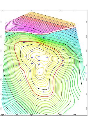
A salt dome is a type of structural dome formed when salt intrudes into overlying rocks in a process known as diapirism. Salt domes can have unique surface and subsurface structures, and they can be discovered using techniques such as seismic reflection. They are important in petroleum geology as they can function as petroleum traps.

<span class="mw-page-title-main">Occidental Petroleum</span> American oil company

Occidental Petroleum Corporation is an American company engaged in hydrocarbon exploration in the United States, and the Middle East as well as petrochemical manufacturing in the United States, Canada, and Chile. It is organized in Delaware and headquartered in Houston. The company ranked 183rd on the 2021 Fortune 500 based on its 2020 revenues and 670th on the 2021 Forbes Global 2000.

Lake Peigneur is a brackish lake in the U.S. state of Louisiana, 1.2 miles north of Delcambre and 9.1 mi (14.6 km) west of New Iberia, near the northernmost tip of Vermilion Bay. With a maximum depth of 200 feet, it is the deepest lake in Louisiana. Its name comes from the French word "peigneur", meaning "one who combs."

<span class="mw-page-title-main">Anticline</span> In geology, an anticline is a type of fold that is an arch-like shape

In structural geology, an anticline is a type of fold that is an arch-like shape and has its oldest beds at its core, whereas a syncline is the inverse of an anticline. A typical anticline is convex up in which the hinge or crest is the location where the curvature is greatest, and the limbs are the sides of the fold that dip away from the hinge. Anticlines can be recognized and differentiated from antiforms by a sequence of rock layers that become progressively older toward the center of the fold. Therefore, if age relationships between various rock strata are unknown, the term antiform should be used.

<span class="mw-page-title-main">Louisiana Offshore Oil Port</span>

The Louisiana Offshore Oil Port (LOOP) is a deepwater port in the Gulf of Mexico 29 kilometers off the coast of Louisiana near the town of Port Fourchon. LOOP provides tanker offloading and temporary storage services for crude oil transported on some of the largest tankers in the world. Most tankers offloading at LOOP are too large for U.S. inland ports. LOOP handles 13 percent of the nation's foreign oil, about 1.2 million barrels (190,000 m3) a day, and connects by pipeline to 50 percent of the U.S. refining capability.

<span class="mw-page-title-main">Vulcan Materials Company</span> American construction materials company

Vulcan Materials Company is an American company based in Birmingham, Alabama. It is principally engaged in the production, distribution and sale of construction materials. Vulcan is the largest producer of construction materials, primarily gravel, crushed stone, and sand, and employs approximately 12,000 people at over 400 facilities. Vulcan serves 22 states, the District of Columbia, Mexico, Canada, Bahamas and the U.S. Virgin Islands. Vulcan's innovative Crescent Market project led to construction of a large quarry and deep water seaport on the Yucatán Peninsula of Mexico, just south of Cancun. This quarry supplies Tampa, New Orleans, Houston, and Brownsville, Texas, as well as other Gulf coast seaports, with crushed limestone via large 62,000-ton self-discharging ships.

<span class="mw-page-title-main">Petroleum reservoir</span> Subsurface pool of hydrocarbons

A petroleum reservoir or oil and gas reservoir is a subsurface accumulation of hydrocarbons contained in porous or fractured rock formations. Such reservoirs form when kerogen is created in surrounding rock by the presence of high heat and pressure in the Earth's crust.

<span class="mw-page-title-main">Geography of Houston</span> Geogrsphic aspects of Texas most populous city

Houston, the most populous city in the Southern United States, is located along the upper Texas Gulf Coast, approximately 50 miles (80 km) northwest of the Gulf of Mexico at Galveston. The city, which is the ninth-largest in the United States by area, covers 601.7 square miles (1,558 km2), of which 579.4 square miles (1,501 km2), or 96.3%, is land and 22.3 square miles (58 km2), or 3.7%, is water.

<span class="mw-page-title-main">Louann Salt</span>

The Louann Salt is a widespread evaporite formation that formed in the Gulf of Mexico during the Callovian in the mid Jurassic. The Louann formed in a rift as the South American and North American Plates separated, from an embayment of the Pacific Ocean. The Louann underlies much of the northern Gulf Coast from Texas to the Florida panhandle and extends beneath large areas of the Gulf Coastal Plain of Mississippi, Louisiana and Texas.

<span class="mw-page-title-main">Goose Creek Oil Field</span> Oil field in the U.S. state of Texas

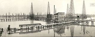
The Goose Creek Oil Field is a large oil field in Baytown, Texas, on Galveston Bay. Discovered in 1903, and reaching maximum production in 1918 after a series of spectacular gushers, it was one of the fields that contributed to the Texas Oil Boom of the early 20th century. The field was also the location of the first offshore wells in Texas, and the second group of offshore wells in the United States. Consequences of the development of the Goose Creek field included an economic boom and associated influx of workers, the founding and fast growth of Baytown, and the building of the adjacent Baytown Refinery, which is now the 2nd largest oil refinery in the United States with a capacity of 584,000 barrels per day. The field remains active, having produced over 150 million barrels (24,000,000 m3) of oil in its 100-year history.

<span class="mw-page-title-main">Scott Angelle</span> American politician

Scott Anthony Angelle is an American politician who is the former director of the Bureau of Safety and Environmental Enforcement in Washington, D.C. From 2013 to 2017, he was the District 2 member of the Louisiana Public Service Commission, an elected five-person utility regulatory body.

Bayou Corne is an unincorporated community and census-designated place (CDP) in Assumption Parish, Louisiana, United States, along the bayou of the same name. It is in the northwestern part of the parish along Louisiana Highway 70, 7 miles (11 km) west of Paincourtville and 6 miles (10 km) northeast of Pierre Part. The Bayou Corne sinkhole is less than one mile to the southeast.

References

  1. WVUE. "Bayou Corne Sinkhole Evacuation Reduced from Mandatory to Voluntary for just 2 of 159 Homes". Fox 8 New Orleans. Retrieved 4 December 2014.
  2. Cusanza, Kris. "Bayou Corne evacuation order could last for years". NBC33. Retrieved 24 July 2013.
  3. Hebert, Tim. "Exile Destination: Louisiana". Acadian Cajun Genealogy & History. Retrieved 2014-04-10.
  4. Beckman, Jeffery. "USGS Report On Gulf Coast Salt Domes" (PDF). United States Geological Survey. Retrieved 5 March 2014.
  5. King, Hobart. "What is a Salt Dome?". Geology.com. Retrieved April 10, 2014.
  6. Freeman, Shanna (27 November 2007). "How Salt Works". How Stuff Works. Retrieved 2014-04-10.
  7. "Strategic Petroleum Reserve". Office of Fossil Energy. Retrieved 2014-04-10.
  8. Bellows, Alan. "Lake Peigneur: The Swirling Vortex of Doom" . Retrieved 2014-04-10.
  9. "DNR Report on Napoleonville Salt Dome" (PDF). The Examiner. October 10, 2012. Archived from the original (PDF) on January 17, 2013. Retrieved 5 March 2014.
  10. "How the Great Louisiana Sinkhole Came To Be". The Louisiana Sinkhole Bugle. September 17, 2013. Retrieved 5 March 2014.
  11. 1 2 3 4 5 6 7 8 Murphy, Tim. "Meet the Town Being Swallowed Up By a Sinkhole". The Atlantic. Retrieved March 5, 2014.
  12. Baig, A.M. (2013). "Characterizing Micro- and Macro-Scale Seismicity from Bayou Corne, Louisiana". NASA Astrophysics Data System. 2013. American Geophysical Union. Bibcode:2013AGUFM.S33D2452B.
  13. "Evacuation Proclamation" (PDF). August 3, 2012. Retrieved 5 March 2014.
  14. Savage, Karen. "Mysterious environmental disaster unfolding in Louisiana bayou community atop gas storage caves". The Institute for Southern Studies. Retrieved April 10, 2014.
  15. Jones, CE (Fall 2013). "Measurement of Sinkhole Formation and Progression with InSAR". AGU Fall Meeting Abstracts. 2013. American Geophysical Union. Bibcode:2013AGUFMNH21C..05J.
  16. Stanley, Charlton (12 January 2014). "Bayou Corne Sinkhole: an Update on the Louisiana Enviornmental [sic] Disaster". January 11, 2014. Retrieved October 6, 2015.
  17. Texas Brine (January 22, 2015). "Bayou Corne Incident". Texas Brine. Retrieved 6 October 2015.
  18. Associated Press. "New Bubbles Found In Bayou Corne Area Sinkhol". The Washington Times . Retrieved April 10, 2014.
  19. David J Mitchell (March 13, 2014). "Sinkhole Shows Signs of Stabilizing, Expert Says". The Advocate. Archived from the original on 7 April 2014. Retrieved 13 March 2014.
  20. Nunn, JA (Fall 2013). "Bubbles, Bubbles, Tremors & Trouble: The Bayou Corne Sinkhole". AGU Fall Meeting Abstracts. 2013. American Geophysical Union. Bibcode:2013AGUFMNG11A1577N.
  21. Clapp, Jake (2018-10-12). "Documentary looks at community impact of Bayou Corne sinkhole". The Advocate (Baton Rouge). Retrieved 2021-07-10.
  22. Stride, Megan. "Class Action Blames Texas Brine For La. Sinkhole". LexisNexis Law360. Retrieved 2014-04-10.
  23. "Texas Brine to pay sinkhole evacuees $875 per week". KATC News. Archived from the original on April 13, 2014. Retrieved April 10, 2014.
  24. "Governor Bobby Jindal: State Suing Texas Brine for Environmental Damage Caused by Failed Texas Brine Cavern". State of Louisiana Office of the Governor. Retrieved April 10, 2014.
  25. "Texas Brine Updated Objectives Facts Sheet" (PDF). Texas Brine, LLC. Retrieved April 10, 2014.
  26. David J. Mitchell (November 20, 2013). "Lawyers Push Forward With Lawsuits". The Advocate. Archived from the original on 7 April 2014. Retrieved 5 March 2014.
  27. River Parishes Bureau (March 27, 2014). "Bayou Corne sinkhole swallows six more trees". The Advocate. Archived from the original on 7 April 2014. Retrieved 29 March 2014.
  28. "Judge listens to complaints from former Bayou Corne residents, but finds the sinkhole settlement and attorney fees to be fair".
  29. Nunn, Jeffrey A. "Bubble, Bubble, Tremors, and Trouble: The Bayou Corne Sinkhole in Assumption Parish, Louisiana." (2014): 303-317.
  30. Jones, Cathleen E., and Ronald Blom. "Pre-event and post-formation ground movement associated with the Bayou Corne sinkhole." (2015).
  31. Mitchell, David. "Judge: Fault for Bayou Corne sinkhole lies with Texas Brine, OxyChem, Vulcan; companies had decades of warnings". The Advocate. Retrieved 2018-04-21.