
Bruce Peninsula National Park is a national park on the Bruce Peninsula in Ontario, Canada. Located on a part of the Niagara Escarpment, the park comprises 156 square kilometres and is one of the largest protected areas in southern Ontario, forming the core of UNESCO's Niagara Escarpment World Biosphere Reserve. The park offers opportunities for many outdoor activities, including hiking, camping, and bird watching. The park has trails ranging in difficulty from easy to expert, and connects to the Bruce Trail.

The Bruce Trail is a hiking trail in southern Ontario, Canada, from the Niagara River to the tip of Tobermory, Ontario. The main trail is more than 890 km (550 mi) long and there are over 400 km (250 mi) of associated side trails. The trail mostly follows the edge of the Niagara Escarpment, one of the thirteen UNESCO World Biosphere Reserves in Canada. The land the trail traverses is owned by the Government of Ontario, local municipalities, local conservation authorities, private landowners, and the Bruce Trail Conservancy (BTC). The Bruce Trail is the oldest and longest marked hiking trail in Canada. Its name is linked to the Bruce Peninsula and Bruce County, through which the trail runs. The trail is named after the county, which was named after James Bruce, 8th Earl of Elgin who was Governor General of the Province of Canada from 1847 to 1854.

The Niagara Escarpment is a long escarpment, or cuesta, in the United States and Canada that runs predominantly east–west from New York through Ontario, Michigan, Wisconsin, and Illinois. The escarpment is most famous as the cliff over which the Niagara River plunges at Niagara Falls, for which it is named.

Halton Hills is a town in the Regional Municipality of Halton, located in the northwestern end of the Greater Toronto Area, Ontario, Canada with a population of 61,161 (2016).
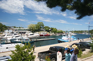
Tobermory is a small community located at the northern tip of the Bruce Peninsula, in the traditional territory of the Saugeen Ojibway Nation. Until European colonization in the mid-19th century, the Bruce Peninsula was home to the Saugeen Ojibway nations, with their earliest ancestors reaching the area as early as 7500 years ago. It is part of the municipality of Northern Bruce Peninsula. It is 300 kilometres northwest of Toronto. The closest city to Tobermory is Owen Sound, 100 kilometres south of Tobermory and connected by Highway 6.
The Regional Municipality of Halton, or Halton Region, is a regional municipality in Ontario, Canada, located in the Golden Horseshoe of Southern Ontario. It comprises the city of Burlington and the towns of Oakville, Milton, and Halton Hills. The region provides policing by the Halton Regional Police Service. The regional council's headquarters are located in Oakville. Burlington and Oakville are largely urban and suburban, while the towns of Milton and Halton Hills are more rural.

The Bruce Peninsula is a peninsula in Ontario, Canada, that lies between Georgian Bay and the main basin of Lake Huron. The peninsula extends roughly northwestwards from the rest of Southwestern Ontario, pointing towards Manitoulin Island, with which it forms the widest strait joining Georgian Bay to the rest of Lake Huron. The Bruce Peninsula contains part of the geological formation known as the Niagara Escarpment.
Royal Botanical Gardens (RBG) is headquartered in Burlington owning extensive environmental protection areas and cultural gardens lands in Hamilton, Ontario, Canada. It is one of the major tourist attractions between Niagara Falls and Toronto, as well as a significant local and regional horticultural, education, conservation, and scientific resource. The mandate is derived by provincial Act of 1941 centred on human interaction with the natural world and protection of environmentally significant lands that form the western tip of Lake Ontario. The property spans and area of about 10 km by 4 km, dominated by two coastal wetlands, and glacial carved landscapes that extends from the lake up to the Niagara Escarpment plateau. The various sites are accessed through 9 public entrance locations. On 31 July 2006, Royal Botanical Gardens was selected as the National Focal Point for the Global strategy for plant conservation (GSPC) by Environment Canada.

Rattlesnake Point is an eco-tourism area located in Milton, Ontario, Canada and is owned and operated by Conservation Halton. Spanning roughly one-hundred square kilometres across and near the Niagara Escarpment in Halton Region, the Rattlesnake Point area is home to many golf courses, country markets and equestrian training and boarding facilities. It is a popular scouting area.

Jordan is a community located on the eastern edge of the Town of Lincoln, in the Niagara Region. Jordan is bordered by the Twenty Mile Creek and Vineland to the west, Lake Ontario to the north, St. Catharines to the east, and Pelham to the south. Lying roughly 100 km from Toronto and 65 km from Buffalo by road, Jordan is located along a major transportation corridor between Canada and the United States. In January 2014 Jordan was brought to international attention when Al-Qaeda-directed terrorists were arrested for plotting to derail a passenger train traveling from Toronto to New York on a rail-bridge crossing the Jordan Harbour.
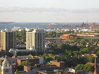
Hamilton is located on the western end of the Niagara Peninsula and wraps around the westernmost part of the Lake Ontario. Most of the city including the downtown section lies along the south shore. Situated in the geographic centre of the Golden Horseshoe, it lies roughly midway between Toronto and Buffalo. The two major physical features are Hamilton Harbour marking the northern limit of the city and the Niagara Escarpment running through the middle of the city across its entire breadth, bisecting the city into 'upper' and 'lower' parts.
The Hamilton–Brantford–Cambridge Trails are a network of multi-use interurban recreational rail trails connecting several municipalities in Southern Ontario, Canada. The trails are part of the Southern Ontario Loop of the Trans Canada Trail. From end to end, the trail is 80 kilometres (50 mi) long, running from Cambridge South through Paris to Brantford and then East to central Hamilton.

Centennial Parkway, is a Lower City arterial road in Hamilton, Ontario, Canada. It is best known as the western terminus of former King's Highway 20, now maintained by the City of Hamilton. It starts off as Upper Centennial Parkway, a mountain-access road in the City right before the Canadian Pacific Railway line at the backend of Battlefield Park and is a two-way street throughout that extends north over the Queen Elizabeth Way and ends at Beach Boulevard/ Van Wagners Beach Road in front of Confederation Park.
The Twenty Mile Creek is a minor waterway, located in the Niagara Peninsula, Ontario, Canada. The creek is named for the location of its mouth, twenty miles (32 km) west of the Niagara River along the Lake Ontario shoreline. The Indian name for the Twenty Mile Creek was the Kenachdaw, which translates to Lead River.

The Eramosa Karst is a provincially significant Earth Science Area of Natural and Scientific Interest in Ontario, Canada, located in Stoney Creek, a constituent community of the City of Hamilton, and immediately south of the Niagara Escarpment.

Twelve Mile Creek is a waterway located on the Niagara Peninsula in the Regional Municipality of Niagara in Southern Ontario, Canada. Its headwaters are located in the town of Pelham, encompassing some of the most unspoiled and natural areas of Niagara area. The creek's lower reaches flow through urban areas of Thorold and St. Catharines, and have been heavily altered by human activity for almost two centuries.
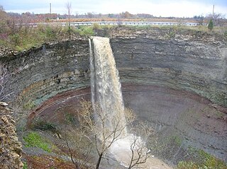
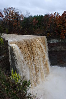
Devil's Punch Bowl is a 37-metre ribbon waterfall on the Niagara Escarpment, in the Stoney Creek community of Hamilton, Ontario, Canada. It is found in the Devil's Punchbowl Conservation Area, maintained by the Hamilton Conservation Authority, and features an escarpment access trail with connections to a recently improved section of the Bruce Trail. Stoney Creek's Dofasco 2000 Trail is nearby. The Punch Bowl is also known as Horseshoe Falls for the distinctive shape of the cliff-face, which somewhat resembles its much larger cousin in Niagara Falls.

Dundas Valley Conservation Area is located on the Niagara Escarpment in Dundas, Ontario, a constituent community of Hamilton, Ontario, and is owned and operated by the Hamilton Conservation Authority. Its 40-kilometre trail system provides a connection to the Bruce Trail. The area contains a trailhead of the Hamilton-Brantford-Cambridge Trails, Canada's first fully developed interurban multi-use trail system, which is a part of the Trans Canada Trail.

Sixteen Mile Creek is a stream in the municipalities of Lincoln, Pelham and West Lincoln, Regional Municipality of Niagara in Southern Ontario, Canada. It is part of the Great Lakes Basin and flows from the top of the Niagara Escarpment to Sixteen Mile Pond on Lake Ontario. The stream falls within the remit of the Niagara Peninsula Conservation Authority, whose 2012 watershed report card gave the stream watershed grades of D for both water quality and forest cover.
The Niagara Peninsula Conservation Authority is one of 36 conservation authorities in the Canadian province of Ontario. It was established via the Conservation Authorities Act, and is a member authority of Conservation Ontario.
