
Crook County is a county in the northeastern section of the U.S. state of Wyoming. As of the 2020 United States Census, the population was 7,181, making it the third-least populous county in Wyoming. Its county seat is Sundance.

Sundance is a town in and the county seat of Crook County, Wyoming, United States. Its population was 1,032 at the 2020 census. The town is named after the Sun Dance ceremony practiced by several American Indian tribes.

Devils Tower is a butte, possibly laccolithic, composed of igneous rock in the Bear Lodge Ranger District of the Black Hills, near Hulett and Sundance in Crook County, northeastern Wyoming, above the Belle Fourche River. It rises 1,267 feet (386 m) above the Belle Fourche River, standing 867 feet (264 m) from summit to base. The summit is 5,112 feet (1,558 m) above sea level.

Devils Postpile National Monument is a U.S. National Monument located near Mammoth Mountain in Eastern California. The monument protects Devils Postpile, an unusual rock formation of columnar basalt, “all closely and perfectly fitted together like a vast mosaic.” The monument encompasses 798 acres (323 ha) and includes two main attractions: the Devils Postpile formation and Rainbow Falls, a waterfall on the Middle Fork of the San Joaquin River. In addition, the John Muir Trail and Pacific Crest Trail merge into one trail as they pass through the monument. Excluding a small developed area containing the monument headquarters, visitor center and a campground, the National Monument lies within the borders of the Ansel Adams Wilderness.

The Bighorn Mountains are a mountain range in northern Wyoming and southern Montana in the United States, forming a northwest-trending spur from the Rocky Mountains extending approximately 200 mi (320 km) northward on the Great Plains. They are separated from the Absaroka Range, which lie on the main branch of the Rockies to the west, by the Bighorn Basin. Much of the land is contained within the Bighorn National Forest.

The Wind River Range is a mountain range of the Rocky Mountains in western Wyoming in the United States. The range runs roughly NW–SE for approximately 100 mi (160 km). The Continental Divide follows the crest of the range and includes Gannett Peak, which at 13,802 ft (4,207 m), is the highest peak in Wyoming; and also Fremont Peak at 13,750 ft (4,191 m), the third highest peak in Wyoming. There are more than 40 other named peaks in excess of 12,999 ft (3,962 m). With the exception of the Grand Teton in the Teton Range, the next 19 highest peaks in Wyoming after Gannett are also in the Winds.

The Belle Fourche River is a tributary of the Cheyenne River, approximately 290 miles (470 km) long, in the U.S. states of Wyoming and South Dakota. It is part of the Mississippi River watershed via the Cheyenne and Missouri rivers. In the latter part of the 19th century, the Belle Fourche River was known as the North Fork of the Cheyenne River. Belle Fourche is a name derived from French meaning "beautiful fork".

The Cheyenne River, also written Chyone, referring to the Cheyenne people who once lived there, is a tributary of the Missouri River in the U.S. states of Wyoming and South Dakota. It is approximately 295 miles (475 km) long and drains an area of 24,240 square miles (62,800 km2). About 60% of the drainage basin is in South Dakota and almost all of the remainder is in Wyoming.

Black Hills National Forest is located in southwestern South Dakota and northeastern Wyoming, United States. The forest has an area of over 1.25 million acres (5,066 km²) and is managed by the Forest Service. Forest headquarters are located in Custer, South Dakota. There are local ranger district offices in Custer, Rapid City, and Spearfish in South Dakota, and in Sundance, Wyoming.
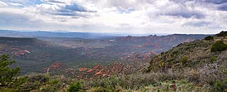
Sycamore Canyon Wilderness is a 56,000-acre wilderness area in the Coconino, Kaibab and Prescott national forests in the U.S. state of Arizona. Encompassing Sycamore Canyon and its surrounds from south of Williams to the confluence of Sycamore Creek with the Verde River, the wilderness is about 40 miles (64 km) southwest of Flagstaff. The canyon is one of several in Arizona that cut through the Mogollon Rim. Relevant United States Geological Survey (USGS) map quadrangles are Davenport Hill, White Horse Lake, May Tank Pocket, Perkinsville, Sycamore Basin, and Clarkdale. Red Rock-Secret Mountain Wilderness borders Sycamore Canyon Wilderness on the east.

The Blue Mountains ecoregion is a Level III ecoregion designated by the United States Environmental Protection Agency (EPA) in the Pacific Northwest, mainly in the state of Oregon, with small areas over the state border in Idaho and southeastern Washington. It is also contiguous with the World Wildlife Fund's Blue Mountain forests ecoregion.

Beulah is a census-designated place (CDP) in eastern Crook County, Wyoming, United States, along Sand Creek, a tributary of the Belle Fourche River. According to local residents, the population is 33. When the 2010 census reported the population as 73, the highway sign at the town entrance was changed. In 2012, Beulah residents succeeded in appealing to the Wyoming Governor to remove the new sign and replace it with one that proclaimed the population to be 33.
Bear Lodge National Forest is a discontinued entity which has been absorbed into the Black Hills National Forest. It is located in the U.S. in the state of Wyoming, in the north central part of the American mainland. It was established in the Bear Lodge Mountains by the U.S. Forest Service in Wyoming on July 1, 1907 with 136,784 acres (553.55 km2). The forest was named for Devils Tower or the "Bear Lodge". On July 1, 1908 the forest was combined with part of Black Hills National Forest to establish Sundance National Forest and the name was discontinued. The lands are presently included in Black Hills National Forest.

The Black Hills is an isolated mountain range rising from the Great Plains of North America in western South Dakota and extending into Wyoming, United States. Black Elk Peak, which rises to 7,244 feet (2,208 m), is the range's highest summit. The Black Hills encompass the Black Hills National Forest. The name of the hills in Lakota is Pahá Sápa. The Black Hills are considered a holy site. The hills are so called because of their dark appearance from a distance, as they are covered in evergreen trees.

Inyan Kara Mountain is a mountain associated with the Bear Lodge Mountains of Crook County, Wyoming, that is considered sacred by the Lakota people, particularly for mothers in childbirth. Inyan Kara stands apart from the main body of the Black Hills, with an elevation of 6,368 feet (1,941 m). The mountain was stated to rumble on quiet days by the local Native Americans and by early explorers. No mention of the noises is found after 1833; the noise has been attributed to gas escaping from burning coal seams.

The ecology of the Rocky Mountains is diverse due to the effects of a variety of environmental factors. The Rocky Mountains are the major mountain range in western North America, running from the far north of British Columbia in Canada to New Mexico in the southwestern United States, climbing from the Great Plains at or below 1,800 feet (550 m) to peaks of over 14,000 feet (4,300 m). Temperature and rainfall varies greatly also and thus the Rockies are home to a mixture of habitats including the alpine, subalpine and boreal habitats of the Northern Rocky Mountains in British Columbia and Alberta, the coniferous forests of Montana and Idaho, the wetlands and prairie where the Rockies meet the plains, a different mix of conifers on the Yellowstone Plateau in Wyoming and in the high Rockies of Colorado and New Mexico, and finally the alpine tundra of the highest elevations.

Missouri Buttes or Little Missouri Buttes are located in Crook County in northeast Wyoming on the northwest flank of the Black Hills Uplift. The buttes are 3.5 miles (5.6 km) northwest (N60°W) of Devils Tower between the Little Missouri and the Belle Fourche rivers.
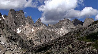
Watch Tower is a mountain located in the southern Wind River Range in the U.S. state of Wyoming. Watch Tower is on the west side of the Cirque of the Towers, a popular climbing area and is just southeast of Block Tower. Watch Tower is immediately east of the Continental Divide.
The Inyan Kara Group is a geologic group classification applied in South Dakota and adopted in portions of Wyoming and Montana. It preserves fossils of the mid-Cretaceous period. Of late Albian age, this classification correlates with the lower Dakota Formation known in the southwest corner of the State.

The Elk Mountains are a small range of mountains in western South Dakota, forming the southwest portion of the Black Hills as part of its west-dipping monocline. They are geologically distinct from the Black Hills, on the other side of a "racetrack" region of red stone. The ridge of the Elk Mountains is formed of harder sandstones. The east face of the Elk Mountains is a 300-to-800-foot high escarpment, but the west portion falls slowly and features many canyons.


