Bear River 6A
Location of Bear River 6A in Nova Scotia
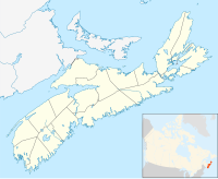
Bear River 6A is a 31.2ha Mi'kmaq reserve located in Annapolis County, Nova Scotia. It is administratively part of the Bear River First Nation. [1] [2]
Bear River 6A is a 31.2ha Mi'kmaq reserve located in Annapolis County, Nova Scotia. It is administratively part of the Bear River First Nation. [1] [2]

Blaine County is a county in the U.S. state of Montana. As of the 2020 United States Census, the population was 7,044. Its county seat is Chinook. The county was named for James G. Blaine, former United States Secretary of State. It is on the north line of the state, and thus shares the southern border of Canada opposite Saskatchewan.

Bear Creek is a census-designated place (CDP) in Kenai Peninsula Borough, Alaska, United States. At the 2020 census the population was 2,129 up from 1,956 in 2010. Bear Creek is a few miles north of Seward near the stream of the same name and its source, Bear Lake.

Kaktovik is a city in North Slope Borough, Alaska, United States. The population was 239 at the 2010 census.

Bear Creek is a village in Hays County, Texas, United States. The population was 382 at the 2010 census.
Port Royal is a toponym for a rural intersection on the north bank of the Annapolis Basin about 8 km (5.0 mi) from the town of Annapolis Royal in Annapolis County, Nova Scotia, Canada. It has no legal status in local government. It is the site of the Port-Royal National Historic Site, a replica of an Acadian settlement that existed from 1605 until its destruction by the English in 1613.
Great Bear Lake is a lake in the boreal forest of Canada. It is the largest lake entirely in Canada, the fourth-largest in North America, and the eighth-largest in the world by surface area. The lake is in the Northwest Territories, on the Arctic Circle between 65 and 67 degrees of northern latitude and between 118 and 123 degrees western longitude, 156 m (512 ft) above sea level.

The Thompson–Nicola Regional District is a regional district in the Canadian province of British Columbia. The Canada 2006 Census population was 132,663 and the area covers 44,449.49 square kilometres. The administrative offices are in the main population centre of Kamloops, which accounts for 78 percent of the regional district's population. The only other city is Merritt; other municipally-incorporated communities include the District Municipalities of Logan Lake, Barriere and Clearwater and the Villages of Chase, Ashcroft, Cache Creek, Clinton and Lytton, and also the Mountain Resort Municipality of Sun Peaks.

The Annapolis Basin is a sub-basin of the Bay of Fundy, located on the bay's southeastern shores, along the northwestern shore of Nova Scotia and at the western end of the Annapolis Valley.
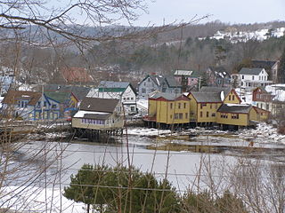
Bear River is a small village situated at the head of the tidewaters of the Bear River. The river itself is the border between the Annapolis and Digby counties of Nova Scotia and thus, splits the village so that half the village is in Annapolis County and the other half in Digby County.
The Shelburne River is a 53 km long river in Nova Scotia, Canada. It is a wilderness river and is a tributary of Mersey River. It starts in the Tobeatic Wilderness Area.

Division No. 19, also informally known as North East Manitoba, is a census division within the Province of Manitoba, Canada. Unlike in some other provinces, census divisions do not reflect the organization of local government in Manitoba. These areas exist solely for the purposes of statistical analysis and presentation; they have no government of their own.
Carleton Corner is a community in the Canadian province of Nova Scotia, located in Annapolis County adjacent to Bridgetown. It is a designated place with a population of 106 in 2016. It is on Nova Scotia Route 201.

Granville Ferry is a village in the Canadian province of Nova Scotia, located in Annapolis County. Granville Ferry is located directly across the Annapolis River from Annapolis Royal, Nova Scotia. It was the northern terminus for ferries running across the river. Granville Ferry was a major shipbuilding centre in the Golden Age of Sail. The village was also home to Bessie Hall, a notable female mariner in the 19th century. The community is named after John Carteret, 2nd Earl Granville. Its population at the 2016 census was 110, a decline of 22.5% since 2011.
Clementsport is a community in the Canadian province of Nova Scotia, located in Annapolis County. It is on the southern shore of the Annapolis Basin and is on Nova Scotia Trunk 1.
Round Hill is an historic community on the Annapolis River in Nova Scotia’s verdant Annapolis Valley halfway between the Valley market towns of Bridgetown and Annapolis Royal. It is 10 kilometres east of Annapolis Royal on Route 201 and the same distance west of Bridgetown.
Bear River 6 is a 649-hectare (1,600-acre) Mi'kmaq reserve located in Annapolis County and Digby County, Nova Scotia. It had a population of 138 individuals in 2016, an increase of 35.3% compared to 2011.
Bear River 6B is a 24.3ha Mi'kmaq reserve located in Annapolis County, Nova Scotia. It has a population of 16 in 2016.

The Digby Gut is a narrow channel connecting the Bay of Fundy with the Annapolis Basin. The town of Digby, Nova Scotia is located on the inner portion of the western side of the Gut. The eastern entrance is marked by the Point Prim Lighthouse. Strong tidal currents, numerous rocky ledges, frequent fogs and unpredictable winds make it a dangerous passage requiring a pilot or local knowledge. Tide flows create 5 knot tidal currents and create numerous whirlpools and eddies. The gut is about a half nautical mile in width and bordered by high rocky cliffs. It marks a break in the North Mountain ridge along the Annapolis Valley and is the eastern end of Digby Neck. Digby Gut had its origins as the northern terminus of the ancient Bear River, part of which is now a drowned river valley.
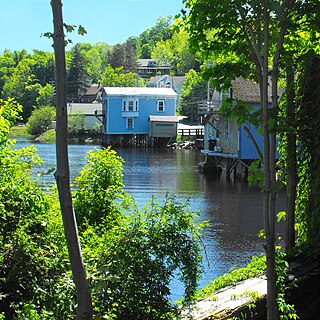
The Bear River is a minor river in western Nova Scotia, Canada. Flowing from south to north, it is 40 kilometres (25 mi) long from its headwaters to its discharge into the Annapolis Basin, some 6 kilometres (3.7 mi) east of Digby. The river is tidal for the last 9.7 kilometres (6.0 mi) of its length. The village of Bear River is situated near the head of the tide where shipbuilding took place in the nineteenth century.
Coordinates: 44°40′06″N65°28′41″W / 44.6683°N 65.47805°W
| | This Annapolis County, Nova Scotia location article is a stub. You can help Wikipedia by expanding it. |