
Yosemite National Park is an American national park in California, surrounded on the southeast by Sierra National Forest and on the northwest by Stanislaus National Forest. The park is managed by the National Park Service and covers an area of 759,620 acres and sits in four counties – centered in Tuolumne and Mariposa, extending north and east to Mono and south to Madera County. Designated a World Heritage Site in 1984, Yosemite is internationally recognized for its granite cliffs, waterfalls, clear streams, giant sequoia groves, lakes, mountains, meadows, glaciers, and biological diversity. Almost 95 percent of the park is designated wilderness. Yosemite is one of the largest and least fragmented habitat blocks in the Sierra Nevada, and the park supports a diversity of plants and animals.

The Sierra Nevada is a mountain range in the Western United States, between the Central Valley of California and the Great Basin. The vast majority of the range lies in the state of California, although the Carson Range spur lies primarily in Nevada. The Sierra Nevada is part of the American Cordillera, an almost continuous chain of mountain ranges that forms the western "backbone" of the Americas.

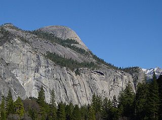
Half Dome is a granite dome at the eastern end of Yosemite Valley in Yosemite National Park, California. It is a well-known rock formation in the park, named for its distinct shape. One side is a sheer face while the other three sides are smooth and round, making it appear like a dome cut in half. The granite crest rises more than 4,737 ft (1,444 m) above the valley floor.
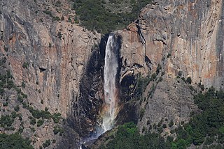
Bridalveil Fall is one of the most prominent waterfalls in the Yosemite Valley in California. The waterfall is 188 metres (617 ft) in height and flows year round.

The Merced River, in the central part of the U.S. state of California, is a 145-mile (233 km)-long tributary of the San Joaquin River flowing from the Sierra Nevada into the San Joaquin Valley. It is most well known for its swift and steep course through the southern part of Yosemite National Park, where it is the primary watercourse flowing through Yosemite Valley. The river's character changes dramatically once it reaches the plains of the agricultural San Joaquin Valley, where it becomes a slow-moving meandering stream.

The Miwok are members of four linguistically related Native American groups indigenous to what is now Northern California, who traditionally spoke one of the Miwok languages in the Utian family. The word Miwok means people in the Miwok languages.

Josiah Dwight Whitney was an American geologist, professor of geology at Harvard University, and chief of the California Geological Survey (1860–1874). Through his travels and studies in the principal mining regions of the United States, Whitney became the foremost authority of his day on the economic geology of the U.S. Mount Whitney, the highest point in the contiguous 48 United States, and the Whitney Glacier, the first confirmed glacier in the United States, on Mount Shasta, were both named after him by members of the Survey.
North Dome is a granite dome in Yosemite National Park, California. It is the southernmost summit of Indian Ridge, 0.6 miles (1.0 km) north of Washington Column and the Royal Arches on the northeastern wall of Yosemite Valley. It can be reached by trail from the Tioga Pass Road, or by going up the Yosemite Falls trail and heading east. It can also be reached from Mirror Lakes by the Snow Creek Falls trail going north around Indian Rock and then south again on the Tioga Pass Road trail. The South Face is precipitous.

Tenaya Lake is an alpine lake in Yosemite National Park, located between Yosemite Valley and Tuolumne Meadows. The surface of Tenaya Lake has an elevation of 8,150 feet (2,484 m). The lake basin was formed by glacial action, which left a backdrop of light granite rocks, whose beauty was known to the Native Americans. Today, Tenaya Lake is easily accessible by State Route 120 and is a popular lake for water activities.

Inyo National Forest is a United States National Forest covering parts of the eastern Sierra Nevada of California and the White Mountains of California and Nevada. The forest hosts several superlatives, including Mount Whitney, the highest point in the contiguous United States; Boundary Peak, the highest point in Nevada; and the Ancient Bristlecone Pine Forest, which protects the oldest living trees in the world. The forest, encompassing much of the Owens Valley, was established by Theodore Roosevelt as a way of sectioning off land to accommodate the Los Angeles Aqueduct project in 1907, making the Inyo National Forest one of the least wooded forests in the U.S. National Forest system.

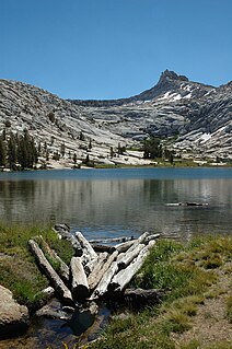
The Cathedral Lakes are two lakes located In Yosemite National Park, Mariposa County, California. The lakes are situated 1.6 km (1 mi) southwest of Cathedral Peak and 3.2 km (2 mi) east-northeast of Tenaya Lake; Tresidder Peak is also near. The lower lake is located at elevation 9,288 feet (2,831 m), while the upper lake is located at elevation 9,585 feet (2,922 m). The John Muir Trail is nearby, with a 7 miles (11 km) round trip hike from the trailhead in Tuolumne Meadows.

Ostrander Lake is located in Yosemite National Park, approximately 10 miles (16 km) south of Yosemite Valley and 10 miles (16 km) east of the Badger Pass Ski Area, at an elevation of 8,500 feet (2,600 m). The lake is a popular destination for cross-country skiers during the winter. It is the primary source of Bridalveil Creek, which feeds Bridalveil Falls.
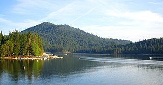
Bass Lake is a census-designated place in Madera County, California. It is located 4.5 miles (7.2 km) southeast of Yosemite Forks, at an elevation of 3415 feet. The population was 527 at the 2010 census.

Mirror Lake is a small, seasonal lake located on Tenaya Creek in Yosemite National Park. Situated in Tenaya Canyon directly between North Dome and Half Dome, it is the last remnant of a large glacial lake that once filled most of Yosemite Valley at the end of the last Ice Age, and is close to disappearing due to sediment accumulation.
Yosemite Forks is an unincorporated community in Madera County, California. It is located 18 miles (29 km) northeast of Raymond, at an elevation of 2907 feet. The road forks at the place: one continues to Yosemite Valley, the other to Bass Lake.
Mono Village is a community in Mono County, California. It is located 11 miles (18 km) southwest of Bridgeport, at an elevation of 7142 feet. It is part of the Twin Lakes census-designated place.
The Pywiack Cascade is a waterfall in Yosemite National Park within the U.S. state of California. It is located a few miles downstream from the outlet of Tenaya Lake on Tenaya Creek at the head of the steep and rugged granite gorge, Tenaya Canyon. The waterfall can be viewed from Glacier Point, or by a 6-mile (9.7 km) hike from Olmsted Point, but the canyon is dangerous and the waterfall is unsafe to be reached on foot. The waterfall is highly seasonal. It typically rages in the spring and early summer while shrinking to a trickle by late summer to mid-autumn.
Arndt Lake is a lake in Yosemite National Park, in California.
Budd Lake is a lake in the Tuolumne Meadows region of Yosemite National Park, United States. Budd Lake is the source of Budd Creek.

Mount Lewis is a 12,350-foot-elevation mountain summit located along the crest of the Sierra Nevada mountain range, in Mono County of northern California, United States. It is situated in the Ansel Adams Wilderness, on land managed by Inyo National Forest. The summit lies less than one mile outside of Yosemite National Park's eastern boundary, and some of the lower western slope lies within the park. The mountain rises 1.8 mile southeast of Mono Pass, 1.5 mile northeast of Parker Pass, and two miles north of Parker Peak, which is the nearest higher neighbor. Topographic relief is significant as it rises over 5,200 feet (1,1585 meters) above Grant Lake in four miles which makes the mountain visible from Highway 395.
