Beckemeyer, Illinois

Last updated

Beckemeyer
Clinton County Illinois Incorporated and Unincorporated areas Beckemeyer Highlighted.svg
Location of Beckemeyer in Clinton County, Illinois.
Illinois in United States (US48).svg
Location of Illinois in the United States
Coordinates: 38°36′21″N89°25′56″W / 38.60583°N 89.43222°W / 38.60583; -89.43222 [1]
CountryUnited States
StateIllinois
County Clinton
Government
  MayorJosh Mensing
Area
[2]
  Total0.62 sq mi (1.60 km2)
  Land0.62 sq mi (1.60 km2)
  Water0.00 sq mi (0.00 km2)
Elevation
[1]
456 ft (139 m)
Population
 (2020)
  Total923
  Density1,495.95/sq mi (577.74/km2)
Time zone UTC-6 (CST)
  Summer (DST) UTC-5 (CDT)
ZIP Code(s)
62219
Area code 618
FIPS code 17-04533
GNIS feature ID2398063 [1]
Public Transit South Central Transit
Wikimedia CommonsBeckemeyer, Illinois
Website http://beckemeyeril.gov/

Beckemeyer is a village in Wade Township, Clinton County, Illinois, United States. The population was 923 as of the 2020 census.

Contents

History

Samuel B. Watkins was reported to be the first settler in the area, circa 1817. Beckemeyer began as a way station on the Ohio and Mississippi Railroad. It was organized and laid out in 1866 and originally named "Buxton" in honor of a railroad attorney.[ citation needed ]

A large coal seam underlying the village and surrounding area was mined starting in 1894, resulting in growth of Buxton. It was renamed "Beckemeyer" after an election held in 1905. The first school and bank were opened in 1906. [3] [4]

On March 25, 1947, the Centralia Coal mine exploded killing 111 people. Nine of the people killed were citizens of Beckemeyer. In 1997 a memorial was built in Beckemeyer, the memorial called "Miners Memorial Park" is dedicated to the miners from Beckemeyer that died in the explosion. [5]

On February 7, 1976, a train crashed into a truck going 56 mph killing 12 people including 11 children, and left another four injured. The accident was the worst in Clinton County History. [6]

A Zinc smelter plant called Circle Smelting Corp operated in the village from 1904 to 1994, in 1993 a study indicated the town was highly contaminated with over 10,000 cubic yards of industrial waste high in lead content from the industry. In 1994 the EPA forced the plant to shut down and declared it a Superfund site. About 35,000 cubic yards of material was removed from over 300 properties and deposited under a concrete cover. [7]

Geography

According to the 2021 census gazetteer files, Beckemeyer has a total area of 0.61 square miles (1.58 km2), all land. [8]

Demographics

Historical population
CensusPop.Note
1910 764
1920 1,15350.9%
1930 850−26.3%
1940 9005.9%
1950 1,04516.1%
1960 1,0561.1%
1970 1,0691.2%
1980 1,1194.7%
1990 1,070−4.4%
2000 1,043−2.5%
2010 1,040−0.3%
2020 923−11.2%
U.S. Decennial Census [9]

As of the 2020 census [10] there were 923 people, 448 households, and 270 families residing in the village. The population density was 1,505.71 inhabitants per square mile (581.36/km2). There were 423 housing units at an average density of 690.05 per square mile (266.43/km2). The racial makeup of the village was 91.22% White, 0.33% African American, 0.11% Native American, 0.65% Asian, 2.17% from other races, and 5.53% from two or more races. Hispanic or Latino of any race were 5.53% of the population.

There were 448 households, out of which 24.3% had children under the age of 18 living with them, 48.44% were married couples living together, 7.14% had a female householder with no husband present, and 39.73% were non-families. 33.93% of all households were made up of individuals, and 16.74% had someone living alone who was 65 years of age or older. The average household size was 3.10 and the average family size was 2.35.

The village's age distribution consisted of 19.0% under the age of 18, 2.8% from 18 to 24, 29.8% from 25 to 44, 25.5% from 45 to 64, and 22.9% who were 65 years of age or older. The median age was 44.3 years. For every 100 females, there were 97.0 males. For every 100 females age 18 and over, there were 106.3 males.

The median income for a household in the village was $51,719, and the median income for a family was $59,097. Males had a median income of $41,413 versus $25,417 for females. The per capita income for the village was $23,015. About 3.7% of families and 7.7% of the population were below the poverty line, including 1.0% of those under age 18 and 1.7% of those age 65 or over.

Schools

Since Beckemeyer is a village, most residents' children go to neighboring towns, such as Breese or Carlyle, for their education. The village does have one elementary school, Breese/Becky District #12; the school houses grades 2 to 4, while older and younger students go to the elementary/middle school, District #12, in the town of Breese.[ citation needed ]

It is in the service area of Central Community High School, formed as a consolidation of the Breese and Aviston high schools in 1971. [11]

Related Research Articles

<span class="mw-page-title-main">Clinton County, Illinois</span> County in Illinois, United States

Clinton County is located in the U.S. state of Illinois. At the 2020 census, the population was 36,899. Its county seat is Carlyle.

<span class="mw-page-title-main">Hayden, Arizona</span> Town in Gila and Pinal Counties, Arizona

Hayden is a town in Gila and Pinal counties in Arizona, United States. According to the 2010 census, the population of the town was 662.

<span class="mw-page-title-main">Ladd, Illinois</span> Village in Illinois, United States

Ladd is a village in Bureau County, Illinois, United States. The population was 1,236 at the 2020 census. It is part of the Ottawa Micropolitan Statistical Area. Ladd is perhaps most known for a Vietnam War tank located in the center of its park.

<span class="mw-page-title-main">Moweaqua, Illinois</span> Village in Illinois, United States

Moweaqua is a village in Shelby and Christian counties, Illinois, United States. The population was 1,764 at the 2020 census.

<span class="mw-page-title-main">Albers, Illinois</span> Village in Illinois, United States

Albers is a village in Clinton County, Illinois, United States. The population was 1,121 at the 2020 census.

<span class="mw-page-title-main">Aviston, Illinois</span> Village in Illinois, United States

Aviston is a village in Clinton County, Illinois, United States. The population was 2,340 at the 2020 census, up from 1,945 at the 2010 census.

<span class="mw-page-title-main">Bartelso, Illinois</span> Village in Illinois, United States

Bartelso is a village in Clinton County, Illinois, United States. The population was 635 at the 2020 census, up from 595 at the 2010 census.

<span class="mw-page-title-main">Breese, Illinois</span> City in Illinois, United States

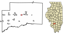
Breese is a city in Clinton County, Illinois, United States. Breese is the most populous city completely within Clinton County. As of the 2020 census, the population was 4,641, the majority of whom are of German ancestry. Breese is part of the Metro-East region of the Greater St. Louis metropolitan area.

<span class="mw-page-title-main">Carlyle, Illinois</span> City in Illinois, United States

Carlyle is a city and county seat of Clinton County, Illinois, United States. The population was 3,253 at the 2020 census.

<span class="mw-page-title-main">Damiansville, Illinois</span> Village in Illinois, United States

Damiansville is a village in Clinton County, Illinois, United States. The population was 564 at the 2020 census, up from 491 at the 2010 census.

<span class="mw-page-title-main">Germantown, Illinois</span> Village in Illinois, United States

Germantown is a village in Clinton County, Illinois, United States. The population was 1,324 at the 2020 census.

<span class="mw-page-title-main">Hoffman, Illinois</span> Village in Illinois, United States

Hoffman is a village in Clinton County, Illinois, United States. The population was 439 at the 2020 census.

<span class="mw-page-title-main">Huey, Illinois</span> Village in Illinois, United States

Huey is a village in Clinton County, Illinois, in the United States. As of the 2020 census, the village population was 160.

<span class="mw-page-title-main">Merrionette Park, Illinois</span> Village in Illinois, United States

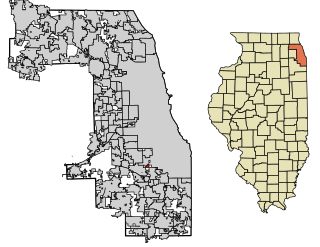
Merrionette Park is a village in Cook County, Illinois, United States. The population was 1,969 as of the 2020 census.

<span class="mw-page-title-main">Coal City, Illinois</span> Village in Illinois, United States

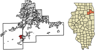
Coal City is a village in Grundy and Will Counties in the U.S. state of Illinois. It is considered a fringe town of the Chicago metropolitan area. The population was 5,705 at the 2020 census.

<span class="mw-page-title-main">Hartford, Illinois</span> Village in Illinois, United States

Hartford is a village in Madison County, Illinois, United States, on the Mississippi River near the mouth of the Missouri River. The population was 1,185 at the 2020 census, down from 1,429 in 2010. Lewis and Clark spent the winter of 1803-04 there, near what has been designated the Lewis and Clark State Historic Site.

<span class="mw-page-title-main">Caseyville, Illinois</span> Village in Illinois, United States

Caseyville is a village in St. Clair County, Illinois, United States. The population was 4,245 at the 2010 census, a decline from 4,310 in 2000.

<span class="mw-page-title-main">Breese Township, Clinton County, Illinois</span> Township in Illinois, United States

Breese Township is one of fifteen townships in Clinton County, Illinois, USA. As of the 2020 census, its population was 5,594 and it contained 2,410 housing units.

<span class="mw-page-title-main">Wade Township, Clinton County, Illinois</span> Township in Illinois, United States

Wade Township is one of fifteen townships in Clinton County, Illinois, USA. As of the 2020 census, its population was 1,625 and it contained 712 housing units. The township's name changed from Beaver Township on June 1, 1874.

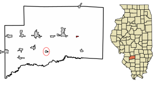
Saint Rose is a village in Clinton County, Illinois, United States. Saint Rose is 5 miles (8.0 km) north-northwest of Breese. The population was 459 as of the 2020 census.

References

  1. 1 2 3 U.S. Geological Survey Geographic Names Information System: Beckemeyer, Illinois
  2. "2020 U.S. Gazetteer Files". United States Census Bureau. Retrieved March 15, 2022.
  3. Village of Beckemeyer website
  4. "1913 Clinton County Commercial History". Archived from the original on July 23, 2011. Retrieved November 10, 2010.
  5. "Illinois Coal & Coal Mining History & Genealogy". Wayne's World of History & Genealogy. Retrieved February 18, 2022.
  6. "11 Children Killed as Train Rams Camper". The New York Times. The New York times. February 9, 1976. Retrieved February 17, 2022.
  7. "CIRCLE SMELTING CORP. BECKEMEYER, IL". EPA. Retrieved September 15, 2021.
  8. Bureau, US Census. "Gazetteer Files". Census.gov. Retrieved June 29, 2022.
  9. "Census of Population and Housing". Census.gov. Retrieved June 4, 2015.
  10. "Explore Census Data". data.census.gov. Retrieved June 28, 2022.
  11. "School / District / Community Profile" (PDF). Central Community High School. Archived from the original (PDF) on February 6, 2015. Retrieved April 5, 2020.