Broadus is a town in and the county seat of Powder River County, Montana, United States. The population was 456 at the 2020 census.
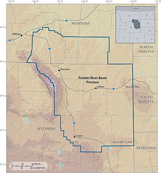
The Powder River Basin is a geologic structural basin in southeast Montana and northeast Wyoming, about 120 miles (190 km) east to west and 200 miles (320 km) north to south, known for its extensive coal reserves. The former hunting grounds of the Oglala Lakota, the area is very sparsely populated and is known for its rolling grasslands and semiarid climate.
Montana Highway 87 (MT 87) is a primary state highway in Madison County in Montana, United States. The highway travels through mainly rural areas in Raynolds Pass, from the Montana–Idaho state line to an intersection with U.S. Route 287 (US 287). The route travels through a portion of Gallatin National Forest. In 1922, a road in the location of MT 87 was added to the highway system, and a few years later the road was designated as portions of two early auto trails. In 1959, the route was rapidly improved due to the collapse of US 287 nearby. During 1967, much of the highway was reconstructed along its current location.
Biddle is a village in southeastern Powder River County, Montana, United States, near the Little Powder River. It lies along Highway 59, south of the town of Broadus, the county seat of Powder River County. Its elevation is 3,337 feet (1,017 m). It offers basic services not only to the community, but those that are passing through as well: a mercantile store with gas pumps, lodging through the mercantile, a post office, a one-room school accommodating grades K-8, a volunteer fire department and a small church.

State Route 45 (SR-45) is a state highway in the U.S. state of Utah. It runs from Dragon Road south of Bonanza in Uintah County north to US-40 in Naples, south of Vernal. The route spans 40.03 miles (64.42 km) south–north.

Melville is an unincorporated community in northern Sweet Grass County, Montana, United States. It lies along local roads just west of U.S. Route 191, north of the city of Big Timber, the county seat of Sweet Grass County. Its elevation is 5,020 feet (1,530 m). Although Melville is unincorporated, it has a post office, with the ZIP code of 59055, which opened on 4 January 1883.

Cohagen is an unincorporated community in southeastern Garfield County, Montana, United States. It lies along Highway 59 southeast of the town of Jordan, the county seat of Garfield County. Its elevation is 2,720 feet (829 m).
Brusett is an unincorporated tiny rural hamlet in northwestern Garfield County, Montana, United States. It lies about the intersection of Brusett Road and Edwards Road, local roads west of the town of Jordan, the county seat of Garfield County. Its elevation is 2,904 feet (885 m). It has a post office, serving the ZIP code of 59318, and a small school house; and no other businesses or services. Google maps personnel have never bothered to go to Brusett.
Sanders is an unincorporated community in northeastern Treasure County, Montana, United States, along the Yellowstone River. It lies along local roads east of the town of Hysham, the county seat of Treasure County, at an elevation of 2,602 feet (793 m). Sanders' post office first opened on March 30, 1904, and closed on October 14, 1905, only to be reopened on December 1, 1906. Although the post office finally closed on July 29, 1994, the community still has a separate ZIP code of 59076.
Olive is an unincorporated community in north central Powder River County, Montana, United States. It lies along Highway 59 northwest of the town of Broadus, the county seat of Powder River County. Its elevation is 3,232 feet (985 m).
Otter is an unincorporated community in southwestern Powder River County, Montana, United States, in the Custer National Forest. It lies along local roads southwest of the town of Broadus, the county seat of Powder River County. Its elevation is 3,484 feet (1,062 m). Although Otter is unincorporated, it has a post office, with the ZIP code of 59062.
Powderville, also Elkhorn Crossing is an unincorporated community in northeastern Powder River County, Montana, United States, along the Powder River. It is a small cluster of buildings that lies along local roads northeast of the town of Broadus, the county seat of Powder River County. Its elevation is 2,828 feet (862 m).
Sonnette is an unincorporated community in west central Powder River County, Montana, United States. The community is situated near the headwaters of Pumpkin Creek, just west of the Custer National Forest. It lies along local roads northwest of the town of Broadus, the county seat of Powder River County.

Beulah is a census-designated place (CDP) in eastern Crook County, Wyoming, United States, along Sand Creek, a tributary of the Belle Fourche River. According to local residents, the population is 33. When the 2010 census reported the population as 73, the highway sign at the town entrance was changed. In 2012, Beulah residents succeeded in appealing to the Wyoming Governor to remove the new sign and replace it with one that proclaimed the population to be 33.

Wyoming Highway 59 is a 171.72-mile-long (276.36 km) north–south state highway that runs from Douglas to the Montana–Wyoming state line, where the roadway continues as Montana Highway 59 (BT 59).

Montana State Highway 48 is a 6.839-mile (11.006 km) state highway in Deer Lodge County, Montana, United States. The highway is 6.839 miles (11.006 km) long, and connects MT 1 to Interstate 90, passing mainly through rural mining areas. MT 48 was first designated in 1938, although portions of a highway existed in the location of MT 48 by at least 1924.

Moorhead is an unincorporated community in southern Powder River County, Montana, United States. It lies along Moorhead Road, approximately 35 miles (56 km) south of the town of Broadus, the county seat of Powder River County.
Coalwood is an unincorporated community in northern Powder River County, Montana, United States. It lies along Montana Highway 59, 23.5 miles (37.8 km) north of the town of Broadus, the county seat of Powder River County.
Epsie is an unincorporated community in western Powder River County, Montana, United States. It lies along U.S. Highway 212, 12.7 miles (20.4 km) west of the town of Broadus, the county seat of Powder River County.

Montana Highway 287 is a state highway in the U.S. state of Montana. The highway runs 42.822 miles (68.915 km) from MT 41 in Twin Bridges east to U.S. Route 287 in Ennis. MT 287 is the primary east–west highway of Madison County. The highway connects the county's four towns, including Sheridan and the county seat of Virginia City. The course of MT 287 follows the ultimate portions of two trails that met in Virginia City, the center of the Alder Gulch gold rush of the mid-1860s and the second territorial capital of Montana. Parts of the highway were improved from rudimentary roads around 1920 from Virginia City to Ennis. This connection became the first portion of Montana Highway 34 in the early 1930s; the highway was extended west to Twin Bridges in the late 1930s. MT 34 was reconstructed from Twin Bridges through Alder to Virginia City in the late 1930s and early 1940s and between Virginia City and Ennis in the late 1940s to mid-1950s. The MT 287 designation was first applied to a cross-state route from West Yellowstone to Canada in the late 1950s. The highway was rerouted in place of MT 34 in the early 1960s. MT 287 was replaced by US 287 along much of the cross-state corridor in the mid-1960s. The highway extended north of Twin Bridges to Whitehall until the late 1970s, when it achieved its current length.