Benjamin G. Humphreys Bridge

Last updated
Benjamin G. Humphreys Bridge
Us82 Greenville Bridge.jpg
A photo of the bridge taken from the Arkansas side.
Coordinates 33°17′37″N91°09′34″W / 33.29361°N 91.15944°W / 33.29361; -91.15944
CarriesFormerly 2 lanes of US 82.svgUS 278.svg US 82  / US 278
Crosses Mississippi River
Locale Lake Village, Arkansas and Greenville, Mississippi
ID number 0000000000M1536
Characteristics
Design Cantilever bridge
Total length9,957 feet (3,035 m)
Width24 feet (7 m)
Longest span840 feet (256 m)
Clearance below 130 feet (40 m)
History
OpenedOctober 4, 1940
ClosedJuly 28, 2010
Location
Benjamin G. Humphreys Bridge

The Benjamin G. Humphreys Bridge was a two-lane cantilevered truss bridge carrying U.S. Route 82/U.S. Route 278 across the Mississippi River between Lake Village, Arkansas and Greenville, Mississippi. It was the first bridge to connect the two towns. The bridge was named for Benjamin G. Humphreys II, a former United States Congressman from Greenville.

Contents

Hailed as progressive when it opened in 1940, it became functionally obsolete as vehicle and river traffic increased. Because of its narrow two lanes with no shoulders, the bridge often became blocked by accidents or by the crossing of large vehicles like farm equipment. Due to its location near a sharp bend in the Mississippi River, the bridge became a hazard to river traffic; barges and towboats frequently collided with it. In 1994, a study concluded that a new bridge was needed and the old one should be torn down. [1]

In 2010, a new bridge, the Greenville Bridge, was opened as a replacement further downriver from the sharp bend. In 2011, work began to remove the Benjamin G. Humphreys Bridge.

Description

The Benjamin G. Humphreys Bridge, very modern in its time, was a two lane, steel cantilevered truss bridge that carried US 82/278 over the Mississippi River, and connected the towns of Lake Village, Arkansas and Greenville, Mississippi by road for the first time. Prior to the bridge, local vehicles and local freight could only cross the river by ferry. [2] It was named after Benjamin G. Humphreys, a US Congressman from Greenville who co-authored a flood control bill in 1917, establishing a national flood control program on the Mississippi and promoted the concept of flood control to contain the river. [3]

The bridge opened on October 4, 1940, to great fanfare. [3] Its main span width was 840 feet (260 m), the highway bridge with the longest span on the Mississippi River. The width of the roadway was 24 feet (7.3 m)two lanes of 12 feet (3.7 m) each with no shoulders. [4]

Both the original bridge and its replacement are geographically mostly in Arkansas, as the state lines were determined prior to the shift west of the Mississippi River.

History

In the late 1930s, talk started on the construction of a bridge to cross the Mississippi River at Greenville. In 1936, a group called the Arkansas-Mississippi-Alabama US 82 Association was formed to raise funds for the bridge. In 1937, Milton C. Smith (the mayor at that time) worked with John A. Fox, (the secretary of the Washington County Chamber of Commerce), to get Congress to pass a law authorizing the bridge. The bill authorizing the bridge was signed into law in August 1937 by President Franklin D. Roosevelt. In 1938, Smith applied for money from the Works Progress Administration to fund the estimated $4.5 million it would take to build the bridge. The Works Progress Administration agreed to the proposal in September 1938 and construction started on the bridge a few months later. [5]

3-D artistic prototype of the new bridge with the Benjamin G. Humphreys Bridge and the sharp bend in the Mississippi River in the background Greenvillebridges.jpg
3-D artistic prototype of the new bridge with the Benjamin G. Humphreys Bridge and the sharp bend in the Mississippi River in the background

The Benjamin G. Humphreys Bridge was built by the company now known as HNTB and opened to much fanfare in 1940 as the "pathway to progress" for the Mississippi Delta. [6] It was a through-truss design and had a span of 840 feet (260 meters). Until 1943, this was the longest bridge for vehicles on the Mississippi River. [7] Over time, the bridge supported increasing volumes of highway traffic and vehicles hitting the bridge. In the 1950s, an Air Force plane crashed into the bridge. Though the bridge remained structurally sound, it was becoming functionally obsolete. [4] It had only two narrow highway lanes and no shoulders. An accident or the crossing of very large vehicles such as a large combine could force the bridge to close. [6]

With river traffic increasing, damage from barge collisions increased. By 1972, the Greenville Bridge was hit more times by barges than any other bridge on the Mississippi. The bridge was located close to a sharp bend in the Mississippi; towboats and barges had difficulty making the sharp turn and regaining their course in time to avoid a collision with the bridge. Over the years many have not been able to make the turn quickly and have hit it. The bridge had become a danger to river traffic. [6]

A 1994 engineering study by the Mississippi Department of Transportation explored alternatives to upgrading the crossing of US 82 and issued a report that explored a four-lane crossing at Greenville. It concluded the best of several alternatives it identified was to build a new bridge 0.5 miles (0.80 km) downriver from the old one and to remove the old bridge. Additional studies evaluated the type of bridge to build, and by 1995, the cable-stayed bridge was chosen as the best design to fit the river and soil conditions, as well as providing sufficient clearance for river navigation. Engineering plans were completed in 1999 for the Greenville Bridge, its replacement. [4]

Destruction

The new Greenville Bridge opened to traffic on August 4, 2010. [6] In 2011, the massive process of removing the old bridge by cutting into small sections to be recycled was begun and was completed in September 2012. [8] At times the river was closed to traffic to aid the demolition. [9] The job was dangerous and two workers died during the demolition.[ citation needed ]

See also

Related Research Articles

<span class="mw-page-title-main">Great River Road</span> Highway designation

The Great River Road is a collection of state and local roads that follow the course of the Mississippi River through ten states of the United States. They are Minnesota, Wisconsin, Iowa, Illinois, Missouri, Kentucky, Tennessee, Arkansas, Mississippi and Louisiana. It formerly extended north into Canada, serving the provinces of Ontario and Manitoba. The road is designated as both a National Scenic Byway and an All-American Road in several states along the route.

<span class="mw-page-title-main">Pusher (boat)</span>

A pusher, pusher craft, pusher boat, pusher tug, or towboat, is a boat designed for pushing barges or car floats. In the United States, the industries that use these vessels refer to them as towboats. These vessels are characterized by a square bow, a shallow draft, and typically have knees, which are large plates mounted to the bow for pushing barges of various heights. These boats usually operate on rivers and inland waterways. Multiple barges lashed together, or a boat and any barges lashed to it, are referred to as a "tow" and can have dozens of barges. Many of these vessels, especially the long distances, or long haul boats, include living quarters for the crew.

<span class="mw-page-title-main">U.S. Route 82</span> Highway in the United States

U.S. Route 82 is an east–west United States highway in the Southern United States. Created on July 1, 1931 across central Mississippi and southern Arkansas, US 82 eventually became a 1,625-mile-long (2,615 km) route extending from the White Sands of New Mexico to Georgia's Atlantic coast.

<span class="mw-page-title-main">I-40 bridge disaster</span> 2002 highway bridge hit in Webbers Falls, Oklahoma, USA

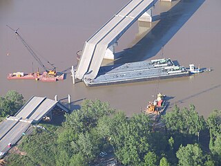
The I-40 bridge disaster was a bridge collapse that occurred southeast of Webbers Falls, Oklahoma, United States at 7:45 a.m. on May 26, 2002. Freight barges being transported on the Arkansas River collided with a pier supporting the Interstate 40 road bridge crossing the river. The resulting failure of the supports caused a section of the bridge to collapse, killing 14 people and injuring another 11. The collision was determined to have resulted from the captain of the barges' towboat losing consciousness.

<span class="mw-page-title-main">Huey P. Long Bridge (Jefferson Parish)</span> Road and railroad bridge in Louisiana, U.S.

The Huey P. Long Bridge, located in Jefferson Parish, Louisiana, is a cantilevered steel through-truss bridge that carries a two-track railroad line over the Mississippi River at mile 106.1, with three lanes of US 90 on each side of the central tracks. It is several kilometers upriver from the city of New Orleans. The East Bank entrance is at Elmwood, Louisiana, and the West Bank at Bridge City.

<span class="mw-page-title-main">Fort Madison Toll Bridge</span> Bridge in and Niota, Illinois

The Fort Madison Toll Bridge is a tolled, double-decked swinging truss bridge over the Mississippi River that connects Fort Madison, Iowa, and unincorporated Niota, Illinois. A double-track railway occupies the lower deck of the bridge, while two lanes of road traffic are carried on the upper deck. The bridge is about 1 mile (1.6 km) long with a swing span of 525 feet (160 m), and was the longest and largest double-deck swing-span bridge in the world when constructed in 1927. It replaced an inadequate combination roadway/single-track bridge completed in 1887. The main river crossing consists of four 270-foot (82 m) Baltimore through truss spans and a swing span made of two equal arms, 266 feet (81 m) long. In 1999, it was listed in the National Register of Historic Places under the title, Fort Madison Bridge, ID number 99001035. It was also documented as survey number IA-62 by the Historic American Engineering Record, archived at the Library of Congress. Construction and photographic details were recorded at the time in Scientific American magazine.

<span class="mw-page-title-main">Wabasha–Nelson Bridge</span> Bridge in Wabasha, Minnesota

The Wabasha–Nelson Bridge is a truss bridge that connects Wabasha, Minnesota with Nelson, Wisconsin, crossing the Mississippi River. The bridge has a street setup, with one lane for motor vehicles in each direction. It carries Minnesota State Highway 60 and WI 25.

<span class="mw-page-title-main">Natchez–Vidalia Bridge</span> Bridge in Louisiana and Natchez, Mississippi

The Natchez–Vidalia Bridge are two twin cantilever bridges carrying U.S. Route 84, and 425 across the Mississippi River between Vidalia, Louisiana and Natchez, Mississippi. It is the tallest bridge in Mississippi.

<span class="mw-page-title-main">Greenville Bridge</span> Bridge in United States of America

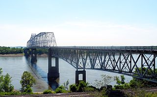
The Greenville Bridge, or the Jesse Brent Memorial Bridge, is a cable-stayed bridge over the Mississippi River, in the United States, carrying US 82 and US 278 between Refuge, Mississippi, and Shives, Arkansas. When it opened in 2010, it was the fourth-longest cable-stayed bridge in North America.

<span class="mw-page-title-main">Helena Bridge</span> Bridge in Arkansas and Lula, Mississippi

The Helena Bridge is a cantilever bridge carrying U.S. Route 49 across the Mississippi River between Helena, Arkansas and Lula, Mississippi.

<span class="mw-page-title-main">Memphis & Arkansas Bridge</span> Highway bridge in Memphis, Tennessee, United States

The Memphis & Arkansas Bridge, also known as the Memphis–Arkansas Bridge or inaccurately as the Memphis–Arkansas Memorial Bridge, is a cantilevered through truss bridge carrying Interstate 55 across the Mississippi River between West Memphis, Arkansas and Memphis, Tennessee. Memphians refer to this bridge as the "Old Bridge" to distinguish it from the "New Bridge", or Hernando de Soto Bridge, upstream.

<span class="mw-page-title-main">Harahan Bridge</span> Bridge between Arkansas and Tennessee, US

The Harahan Bridge is a cantilevered through truss bridge that carries two rail lines and a pedestrian bridge across the Mississippi River between West Memphis, Arkansas, and Memphis, Tennessee. The bridge is owned and operated by Union Pacific Railroad and is the second longest pedestrian/bicycle bridge in the United States. It was built with roadways cantilevered off the sides of the main structure for vehicles. These roadways are owned by the cities of Memphis, Tennessee, and Crittenden County, Arkansas, and were used from 1917–1949, until the Memphis & Arkansas Bridge opened 400 feet (120 m) south of the Harahan. The bridge was named in honor of railroad executive James Theodore Harahan, former president of the Illinois Central Railroad, who was killed in a railroad accident during the construction of the bridge. In February 2011, Union Pacific Railroad officials agreed to the idea of converting the 1917 roadways into a bicycle-pedestrian walkway across the river. In June 2012, Memphis was awarded a $14.9 million federal grant to build the walkway. The overall project was expected to cost $30 million, of which about $11 million was used for the Harahan Bridge portion. Construction was completed in 2016.

<span class="mw-page-title-main">Cairo Mississippi River Bridge</span> Bridge

The Cairo Mississippi River Bridge is a type of cantilever bridge known as a Steel Truss Through Deck carrying U.S. Route 60 and U.S. Route 62 across the Mississippi River. Located in the tri-state area of Illinois, Kentucky, and Missouri, it connects Cairo, Illinois at its northern terminus to Bird's Point, Missouri at its southern terminus. The bridge was most recently closed for renovation from March 16, 2015, to October 13, 2015.

<span class="mw-page-title-main">Chester Bridge</span> Bridge in Missouri and Chester, Illinois

The Chester Bridge is a continuous truss bridge connecting Missouri's Route 51 with Illinois Route 150 across the Mississippi River between Perryville, Missouri and Chester, Illinois. It is the only motor-traffic bridge spanning the Mississippi River between St. Louis and Cape Girardeau, Missouri.

<span class="mw-page-title-main">Wabash Bridge</span> Bridge in Missouri and Pike County, Illinois

The Wabash Bridge carries one railroad track across the Mississippi River between Hannibal, Missouri, and Pike County, Illinois. Built by the Wabash Railroad, the bridge is today owned by the Norfolk Southern Railway.

<span class="mw-page-title-main">La Crosse Rail Bridge</span> Bridge in La Crosse, Wisconsin

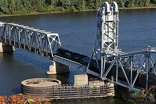
The La Crosse Rail Bridge is a swing bridge that spans the Mississippi River between La Crescent, Minnesota and La Crosse, Wisconsin. The first bridge in this location initially was designed and ready to build by June 1876, and was completed in November 1876 by the Milwaukee and St. Paul Railway, a predecessor of the Chicago, Milwaukee, St. Paul and Pacific Railroad. It was later replaced in 1902. It is at the Western end of the Canadian Pacific Railway Tomah Subdivision. Amtrak's Empire Builder crosses this bridge.

<span class="mw-page-title-main">Arkansas Highway 2</span> Former state highway in Arkansas

State Road 2 is a former east–west state highway in the Arkansas Timberlands and Lower Arkansas Delta. The route was approximately 195 miles (314 km), and ran from US Route 67 (US 67) in Texarkana east to cross the Mississippi River near Lake Village, continuing as Mississippi Highway 10. On July 1, 1931, the route was entirely replaced by US Highway 82 (US 82) by the American Association of State Highway Officials (AASHTO). The route was maintained by the Arkansas Highway Department (AHD), now known as the Arkansas Department of Transportation (ArDOT).

<span class="mw-page-title-main">Arkansas Highway 144</span> Designation for two state highways in Southeast Arkansas

Highway 144 is a designation for two state highways in Southeast Arkansas. One route of 7.82 miles (12.59 km) begins at Big Bayou Meto Use Area and runs east to US Highway 165 (US 165), Highway 1, and the Great River Road (GRR). A second route of 20.50 miles (32.99 km) begins at US 165 near Jerome and runs east through Lake Village to a levee near the Mississippi River. Both routes are maintained by the Arkansas Department of Transportation (ArDOT). While overlapping US 65/US 278 in Chicot County, the route is part of the Great River Road, a national scenic byway following the Mississippi River.

References

  1. "The Quest for a Bridge". US 82 Greenville Bridge. Archived from the original on October 30, 2013. Retrieved April 12, 2014.
  2. "The Quest for a Bridge". US 82 Greensville Bridge. Archived from the original on October 30, 2013. Retrieved January 12, 2012.
  3. 1 2 "The Quest for a Bridge - Part 3". The Quest for a Bridge. US 82 Greensville Bridge. Archived from the original on August 19, 2008. Retrieved January 13, 2012.
  4. 1 2 3 "Project Summary: The New Bridge". US 82 Greenville Bridge. Archived from the original on May 18, 2012. Retrieved January 12, 2012.
  5. "The Quest for a Bridge - Part 2". US 82 Greensville Bridge. Archived from the original on August 7, 2008. Retrieved January 12, 2012.
  6. 1 2 3 4 Lampkin, Sheilla (February 17, 2011). "End of an Era: Greenville Bridge Dismantled". Monticello Live. Retrieved January 12, 2012.
  7. "Project Summary: The 1940 Bridge". US 82 Greenville Bridge. Archived from the original on November 7, 2011. Retrieved January 12, 2012.
  8. "Project Updates for District 3 (Delta Region)". Mississippi Department of Transportation. March 30, 2010. Archived from the original on August 17, 2011. Retrieved January 11, 2012.
  9. "Regulated Navigation Area; Greenville Bridge Demolition, Lower Mississippi River Mile 531.3, AR, MS". November 2, 2010. Federal Register. 2 November 2010. Retrieved January 11, 2012.