
Scioto County is a county located along the Ohio River in the south central region of the U.S. state of Ohio. As of the 2020 census, the population was 74,008. Its county seat is Portsmouth. The county was founded March 24, 1804, from Adams County and is named for a Native American word referring to deer or deer-hunting. Scioto County comprises the Portsmouth, OH Micropolitan Statistical Area. It is located at the confluence of the Scioto and Ohio rivers.

This is a list of properties and districts in Ohio that are listed on the National Register of Historic Places. There are over 4.000 in total. Of these, 73 are National Historic Landmarks. There are listings in each of Ohio's 88 counties.

Minford is a census-designated place located on the border of Harrison and Madison townships in northeastern Scioto County, Ohio, United States, about 14 miles (23 km) northeast of the county seat of Portsmouth. As of the 2010 census, it had a population of 693.
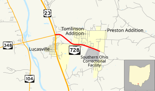
State Route 728 is a short east–west state highway situated in south-central Ohio. At a length of just under 2 miles (3.2 km), the state highway is a spur route that provides access to the Southern Ohio Correctional Facility. The western terminus of SR 728 is at a signalized intersection with U.S. Route 23 (US 23) in Lucasville that doubles as the eastern terminus of SR 348. Its eastern terminus is just east of the Southern Ohio Correctional Facility, at the intersection of Lucasville-Minford Road and Lang Lane (CR 180).
State Route 823 (SR 823), officially known as the Southern Ohio Veterans Memorial Highway and colloquially as the Portsmouth Bypass, is a north–south four-lane divided controlled-access highway in Scioto County, Ohio. The highway, which runs from Sciotodale to Lucasville, reroutes through traffic around the cities of Portsmouth and New Boston to the east. The bypass provides better mobility within the local area for residents and has the potential to increase the economic development of the local area. In September 2013, the Ohio Department of Transportation (ODOT) recommended a public–private partnership (P3) to fund and build the highway. Construction began in June 2015. The highway was dedicated on December 13, 2018 with vehicle traffic beginning the next day.

Minford High School (MHS) is a rural, public, high school located in Minford, Ohio in Scioto County in Southern Ohio. It is the only high school in the Minford Local School District. The school mascot is the falcon and the school colors are scarlet and grey.
Harrison Township is one of the sixteen townships of Scioto County, Ohio, United States. The 2010 census counted 4,548 people in the township.

Byer is an unincorporated community in northwestern Washington Township, Jackson County, Ohio, United States. It lies along State Route 327 between Wellston and Londonderry, at 39°10′53″N82°37′53″W.

Augspurger Schoolhouse is a historic building in Woodsdale, Ohio. The original building was a rectangular schoolhouse. On November 1, 1984 it was listed in the National Register of Historic Places as part of a thematic resource, the "Augspurger Amish/Mennonite Settlement". As of 2016 the building had been demolished and the property left covered in detritus.

The Ashville Depot is a small former train station in the village of Ashville in Pickaway County, Ohio, United States. A simple weatherboaded building that was constructed in 1876, it was once the commercial center of the area.

Mule Town is an unincorporated community in southwestern Madison Township, Scioto County, Ohio, United States. Located at the intersection of State Route 335, Lucasville-Minford Road and Bennett Road, it lies just north of the unincorporated community of Minford, 7 miles east of the census-designated place of Lucasville, and 14 miles (23 km) northeast of the city of Portsmouth, the county seat of Scioto County. Sweet Run, a tributary of the Rocky Fork of the Little Scioto River, flows past the community. Five businesses lie within Mule Town; Mule Town Mini-Mart, Foster and Fankell Garage, Bennet's Collision and Repair, Shumway Tires and the Minford Retirement Center.
Bergstresser / Dietz Bridge, the last remaining covered bridge in Franklin County, Ohio, United States, is located within the village limits of Canal Winchester, Ohio in southeastern Franklin County. The wooden bridge crosses Little Walnut Creek, which is a tributary of the Scioto River. Although the bridge is in serviceable condition, it is only open to foot traffic.
The Portsmouth Earthworks are a large prehistoric mound complex constructed by the Ohio Hopewell culture mound builder indigenous peoples of eastern North America. The site was one of the largest earthwork ceremonial centers constructed by the Hopewell and is located at the confluence of the Scioto and Ohio Rivers, in present-day Ohio.
The Scioto Grange No. 1234, in Jackson, Ohio, served historically as a meeting hall, as a school, and as a specialty store. It was listed on the National Register of Historic Places in 2005.

Everett S. Sherman (1831-1897) was a covered bridge builder in Ohio. He lived and built bridges in Delaware County then moved to Preble County after a storm destroyed many of its bridges.
The Harshman Covered Bridge near Fairhaven, Ohio, was built in 1894 by Everett S. Sherman. It was listed on the National Register of Historic Places in 1976. It was documented by the Historic American Engineering Record (HAER) in 2003.

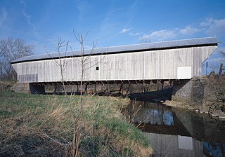
The Otway Covered Bridge, in Scioto County, Ohio north of Ohio State Route 348 in Otway, was built in 1874 by the Smith Bridge Co. of Toledo, Ohio. It was listed on the National Register of Historic Places in 1974.

The Columbus Civic Center is a civic center, a collection of government buildings, museums, and open park space in Downtown Columbus, Ohio. The site is located along the Scioto Mile recreation area and historically was directly on the banks of the Scioto River.

Broad Street is a major thoroughfare in Central Ohio, predominantly in Franklin County and Columbus. It stretches east from West Jefferson at Little Darby Creek to Pataskala. The street is considered one of Columbus's two main roads, along with High Street.

The Hartman Stock Farm Historic District is a historic district in Columbus, Ohio. The district was listed on the National Register of Historic Places in 1974.

