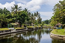
Bali is a province of Indonesia and the westernmost of the Lesser Sunda Islands. East of Java and west of Lombok, the province includes the island of Bali and a few smaller offshore islands, notably Nusa Penida, Nusa Lembongan, and Nusa Ceningan to the southeast. The provincial capital, Denpasar, is the most populous city in the Lesser Sunda Islands and the second-largest, after Makassar, in Eastern Indonesia. The upland town of Ubud in Greater Denpasar is considered Bali's cultural centre. The province is Indonesia's main tourist destination, with a significant rise in tourism since the 1980s. Tourism-related business makes up 80% of its economy.

Banten is the westernmost province on the island of Java, Indonesia. Its capital city is Serang and its largest city is in Tangerang. The province borders West Java and the Special Capital Region of Jakarta on the east, the Java Sea on the north, the Indian Ocean on the south, and the Sunda Strait on the west and shares a maritime border with Bengkulu and Lampung to the east and Bangka Belitung Islands to the north. The province covers an area of 9,662.82 km2 (3,730.84 sq mi). It had a population of over 11.9 million in the 2020 census, up from about 10.6 million in 2010. The estimated mid-2022 population was 12.25 million. Formerly part of the province of West Java, Banten become a province in 2000. The northern half has recently experienced rapid rises in population and urbanization, and the southern half has a more traditional character but an equally fast-rising population.
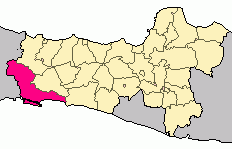
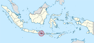
Cilacap Regency is a regency in the southwestern part of Central Java province in Indonesia. Its capital is the town of Cilacap.

Nusa Kambangan island is located in Indonesia, separated by a narrow strait from the south coast of Java. The closest port is Cilacap in Central Java province. It is known as the place where the fabled wijayakusuma, which translates as the 'flower of victory' in the highest literary register of the Javanese language, grows. The wijayakusuma can be used to bring a person back from the dead, and the princes of the Sultanate of Mataram and later the Surakarta Sunanate sent to the island for the blooms in order to become kings. Thus the island is also known as pulau bunga-bungaan, the 'island of many flowers'. There is a forest reserve on the island. One of the main cultural events is Sedekah Laut, which is held by the Surakarta Sunanate every Satu Suro in the Javanese calendar. Since the Dutch colonial period, there have been a number of supermax prisons on the island, some of which are still operational and run by Ministry of Law and Human Rights of Indonesia.
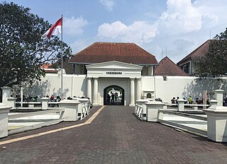
Fort Vredeburg Museum was a former colonial fortress located in the city of Yogyakarta, Special Region of Yogyakarta, Indonesia. The military complex has been converted into a museum of the Indonesian independence struggle which was opened in 1992. It is located in front of Gedung Agung and near the Kraton Yogyakarta.

Fort Rotterdam is a 17th-century fort in Makassar on the island of Sulawesi in Indonesia. It is a Dutch fort built on top of an existing fort of the Gowa Kingdom. The first fort on the site was constructed by the a local sultan in around 1634, to counter Dutch encroachments. The site was ceded to the Dutch under the Treaty of Bongaya, and they completely rebuilt it between 1673 and 1679. It had six bastions and was surrounded by a seven meter high rampart and a two meter deep moat.

Fort Tolukko is a small fortification on the east coast of Ternate facing Halmahera. It was one of the colonial forts built to control the trade in clove spices, which prior to the eighteenth century were only found in the Maluku Islands. It has been variously occupied by the Portuguese, the native Ternate Sultanate, the Dutch, the British and the Spanish. It was abandoned as a fort in 1864, renovated in 1996, and is now a tourist attraction.

The so-called Portuguese Fort, or Benteng Portugis, is a historical fort located in the village Banyumanis adjacent to the village of Ujung Batu, District of Keling, Jepara Regency, the province of Central Java, Indonesia. It is said that the fortress was built by the Government Mataram in 1613–1645, with partnership of the Portuguese as the central defense to repel the enemy who came from Java Sea.

Cultural properties of Indonesia are those items defined by Indonesian law as of "important value for history, science, and culture", and include both man-made artefacts and natural objects. The cultural properties number more than 8,000 and include ancient Hindu and Buddhist temples, mosques, historic colonial buildings, forts, art galleries, national parks and beaches. A number of the sites are World Heritage Sites.

Fort Kastela is a ruined Portuguese fortress located at the southwest coast of Ternate. It is famous for being the first colonial fortification constructed in the Spice Islands (Maluku) of Indonesia. Built by the Portuguese in 1522, it is also referred to in different languages as São João Baptista de Ternate or Fortaleza de Ternate (Portuguese), Ciudad del Rosario (Spanish) or Gammalamma. Today it is locally known as Kastella/Kastela.

The Gedung Agung is one of six presidential palaces of Indonesia, it is located in the city of Yogyakarta. The palace complex covers an area of approximately 4.4 hectares. It is located in front of Fort Vredeburg.
Teluk Penyu Beach is a brown sand beach in Cilacap, Central Java. Named for its former sea turtle population, the beach is one of the most popular tourist attractions in the area.

Karang Bolong Beach is a white-sand beach on the island of Nusa Kambangan in Cilacap Regency, Central Java. Located on the eastern end of the island inside a nature reserve, the beach is situated near an old Dutch fortress, also known as Karang Bolong.

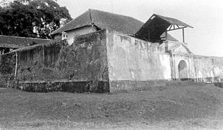
Fort Vastenburg, also Fort Surakarta, is an 18th-century Dutch fort located in Gladak, Surakarta, Central Java, Indonesia. A landmark of Surakarta, the fort faces polemics related with multiple owners claiming different parts of the fort. As a result, the fort remains abandoned and threatened to be demolished by various private parties claiming the fort's ownership.
Fort Willem II of Ungaran is a late 18th-century fort built by the Dutch in Ungaran, Semarang Regency, Central Java, Indonesia. Its main purpose was to control an important trade route between Semarang and Yogyakarta. The fort is the place where Prince Diponegoro was imprisoned while waiting for his judgment in Batavia and further exile to Makassar. The fort is currently used as a dormitory for the families of Indonesian police personnel.

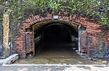
Fort Willem I, known in Indonesian/Javanese as Benteng Pendem Ambarawa, is a 19th-century Dutch fortress in Ambarawa, Central Java, Indonesia.

Fort van den Bosch, locally known as Benteng Pendem, is a fort located in Pelem administrative village, Ngawi (town), Ngawi Regency, Indonesia.
The Madiun River is a river in East Java, Indonesia, about 500 km to the east of the capital Jakarta. It is the largest tributary of the Solo River. Its name indicates that it passes through the major city of Madiun, East Java, Indonesia. This river starts as a number of smaller tributaries converging near the city of Ponorogo, in particular the Kali Slahung, Kali Keyang and Kali Sungkur. It eventually converges with the Solo River near the city of Ngawi.
Ci Tanduy is a river in the island of Java, Indonesia, about 270 km to the southeast of the capital Jakarta. It flows from West Java to Central Java province, exiting through the Bay of Citanduy to the Indian Ocean, forming a delta called "Muara Citanduy."

Ngawi is the capital city of the Indonesian regency of Ngawi. It is also the centre of government and economy of Ngawi Regency. Ngawi is also the name of a district (kecamatan) which is in Ngawi Regency. This district is located 183 km west of Surabaya and 610 km east of Jakarta. Geographically, Ngawi is in the middle of the northern part of Ngawi Regency. Infrastructure and settlements from Ngawi Regency are also concentrated in this town, which is the center of education for Ngawi Regency, with almost a quarter of the total school buildings in Ngawi Regency in this district.