Bernese Alps

Last updated
Bernese Alps
BerneseAlps.jpg
The Eiger, Mönch, and Jungfrau
Highest point
Peak Finsteraarhorn
Elevation 4,274 m (14,022 ft)
Listing Mountains of the Alps over 4000 m
Coordinates 46°32′19″N8°07′38″E / 46.53861°N 8.12722°E / 46.53861; 8.12722
Naming
Native name
Geography
Berner Alpen.png
Map of Bernese Alps and their location in Switzerland (red)
CountrySwitzerland
Cantons Bern, Vaud, Fribourg and Valais
Range coordinates 46°25′30″N7°41′37″E / 46.42500°N 7.69361°E / 46.42500; 7.69361
Parent range Western Alps
Borders on Chablais Alps, Pennine Alps, Lepontine Alps, Uri Alps and Emmental Alps
Topo map Swiss Federal Office of Topography swisstopo

The Bernese Alps (German : Berner Alpen, French : Alpes bernoises, Italian : Alpi bernesi) are a mountain range of the Alps, located in western Switzerland. Although the name suggests that they are located in the Berner Oberland region of the canton of Bern, portions of the Bernese Alps are in the adjacent cantons of Valais, Fribourg and Vaud, the latter being usually named Fribourg Alps and Vaud Alps respectively. The highest mountain in the range, the Finsteraarhorn, is also the highest point in the canton of Bern.

Contents

The Rhône valley separates them from the Chablais Alps in the west and from the Pennine Alps in the south; the upper Rhône valley separates them from the Lepontine Alps to the southeast; the Grimsel Pass and the Aare valley separates them from the Uri Alps in the east, and from the Emmental Alps in the north; their northwestern edge is not well defined, describing a line roughly from Lake Geneva to Lake Thun. The Bernese Alps are drained by the river Aare and its tributary the Saane in the north, the Rhône in the south, and the Reuss in the east.

The Bernese Alps are amongst the three highest major subranges of the Alps, together with the Pennine Alps and the Mont Blanc massif. [1]

Geography

One of the most prominent Alpine ranges, the Bernese Alps extend from the gorge of Saint-Maurice, through which the Rhône finds its way to Lake Geneva, to the Grimsel Pass or, depending on the definition, to the river Reuss (thus including the Uri Alps). The principal ridge, a chain that runs 100 kilometres (62 mi) from west (Dent de Morcles) to east (Sidelhorn), whose highest peak is the Finsteraarhorn, forms the watershed between the cantons of Bern and Valais. Except for the westernmost part, it is also the watershed between the Rhine (North Sea) and the Rhône (Mediterranean Sea). This chain is not centered inside the range but lies close (10 to 15 km) to the Rhône on the south. This makes a large difference between the south, where the lateral short valleys descend abruptly into the deep trench forming the valley of the Rhône and the north, where the Bernese Alps extends through a great part of the canton of Bern (Bernese Oberland), throwing out branches to the west into the adjoining cantons of Vaud and Fribourg. There the mountains progressively become lower and disappear into the hilly Swiss Plateau. [2] The Bernese Alps have a large influence on the climate of Switzerland: while their north side is very exposed to weather, their south side is protected from it. As a consequence, agriculture consists essentially of dairy farming and cattle breeding on the northern foothills, while on the sunnier southern foothills (Rhone Valley) it also consists of vineyards.

Gemmi Pass is the most central of the major passes through the main chain. It also marks the separation between two distinct sections of the Bernese Alps: the chain west of Gemmi Pass, consisting mainly of foothills with a few large glacier-covered mountains (notably Dent de Morcles, Grand Muveran, Diablerets, Wildhorn and Wildstrubel) around 3,000 metres (9,800 ft), and the chain east of Gemmi Pass, consisting mainly of summits around 4,000 metres (13,000 ft) on several subranges, with large valley glaciers between them. The latter section, contrary to the former, has very few foothills and is the most glaciated part of the Alps. [3]

A characteristic in the orography of the Bernese Alps is, that whereas the western portion of that chain consists of a single series of summits with comparatively short projecting buttresses, the higher group presents a series of longitudinal ridges parallel to the axis of the main chain, and separated from each other by deep valleys that form the channels of great glaciers. Thus the Tschingel Glacier and the Kander Glacier, separate the portion of the main range lying between the Gemmi Pass and the Mittaghorn from the equally high parallel range of the Doldenhorn and Blümlisalp on its northern side. To the south, the same portion of the main range is divided from the still higher parallel range whose summits are the Aletschhorn and the Bietschhorn by the Lötschental and the Lötschenlücke. To this again succeeds the deep trench through which the lower part of the Aletsch Glacier flows down to the Rhône, enclosed by the minor ridge that culminates at the Eggishorn. [2]

It is in the central and eastern portions of the range only that crystalline rocks make their appearance; the western part is composed almost exclusively of sedimentary deposits, and the secondary ridges extending through Bern and the adjoining cantons are formed of jurassic, cretaceous, or eocene strata. [2]

Alpine Landscape.jpg
The north side of the Bernese Alps from across the Swiss Plateau
Rhone Valley.jpg
The south side of the Bernese Alps from across the Rhone Valley

Exploration

The Finsteraarhorn is the highest mountain in the Bernese Alps. It is also one of the remotest locations in Switzerland Finsteraarhorn and surrounding mounts.jpg
The Finsteraarhorn is the highest mountain in the Bernese Alps. It is also one of the remotest locations in Switzerland

The beauty of the scenery and the facilities offered to travellers by the general extension of mountain railways make the northern side of the range, the Bernese Oberland, one of the portions of the Alps most visited by tourists. Since strangers first began to visit the Alps, the names of Grindelwald, Lauterbrunnen, and Interlaken have become famous. But unlike many other Alpine regions, which have been left to be explored by strangers, this region has been long visited by Swiss travellers and men of science. Among them were the brother Meyer of Aarau and Franz Joseph Hugi. They have explored most of the mountain ranges not very difficult to access, and have climbed most of the higher summits. In 1841, Louis Agassiz, with several scientific friends, established a temporary station on the Unteraar Glacier, and, along with scientific observations on the glaciers, started a series of expeditions. Several mountains in the area are named after Agassiz and the other explorers. The works of Desor and Gottlieb Studer have been followed by several other publications that bear testimony to Swiss mountaineering activity. Notwithstanding the activity of their predecessors, the members of the English Alpine Club have found scope for further exploits, amongst which may be reckoned the first ascents of the Aletschhorn and the Schreckhorn, and the still more arduous enterprise of crossing the range bypasses, such as the Jungfraujoch and Eigerjoch, which are considered among the most difficult in the Alps. [2]

Jungfrau-Aletsch area

Jungfrau-Aletsch area seen from space Switzerland (14399363612).jpg
Jungfrau-Aletsch area seen from space

The Jungfrau-Aletsch area is located in the eastern Bernese Alps in the most glaciated region of the Alps. It was inscribed as a UNESCO World Heritage Site (Swiss Alps Jungfrau-Aletsch) in 2001 and further expanded in 2007. Its name comes from the Aletsch Glacier and the two summits of the Jungfrau and Bietschhorn, which constitute some of the most impressive features of the site. The actual site (after the extension) includes other large glacier valleys such as the Fiescher Glacier and the Aar Glaciers.

List of peaks

The chief peaks of the Bernese Alps are:

Name Elevation
Finsteraarhorn 4,274 m (14,022 ft)
Aletschhorn 4,182 m (13,720 ft)
Jungfrau 4,166 m (13,668 ft)
Mönch 4,105 m (13,468 ft)
Schreckhorn 4,080 m (13,386 ft)
Grosses Fiescherhorn 4,049 m (13,284 ft)
Grünhorn 4,043 m (13,264 ft)
Lauteraarhorn 4,042 m (13,261 ft)
Hinteres Fiescherhorn 4,025 m (13,205 ft)
Gletscherhorn 3,983 m (13,068 ft)
Rottalhorn 3,969 m (13,022 ft)
Eiger 3,967 m (13,015 ft)
Ebnefluh 3,962 m (12,999 ft)
Agassizhorn 3,946 m (12,946 ft)
Bietschhorn 3,934 m (12,907 ft)
Trugberg 3,933 m (12,904 ft)
Klein Grünhorn 3,913 m (12,838 ft)
Gross Wannenhorn 3,905 m (12,812 ft)
Kleines Fiescherhorn 3,895 m (12,779 ft)
Mittaghorn 3,892 m (12,769 ft)
Fiescher Gabelhorn 3,876 m (12,717 ft)
Schönbühlhorn 3,854 m (12,644 ft)
Nesthorn 3,820 m (12,533 ft)
Dreieckhorn 3,811 m (12,503 ft)
Schinhorn 3,797 m (12,457 ft)
Breithorn (Blatten) 3,785 m (12,418 ft)
Breithorn (Lauterbrunnen) 3,779 m (12,398 ft)
Grosshorn 3,754 m (12,316 ft)
Sattelhorn 3,745 m (12,287 ft)
Kranzberg 3,742 m (12,277 ft)
Geisshorn 3,740 m (12,270 ft)
Klein Lauteraarhorn 3,737 m (12,260 ft)
Wetterhorn 3,708 m (12,165 ft)
Mittelhorn 3,704 m (12,152 ft)
Rotstock 3,699 m (12,136 ft)
Balmhorn 3,698 m (12,133 ft)
Silberhorn 3,695 m (12,123 ft)
Rosenhorn 3,689 m (12,103 ft)
Blüemlisalphorn 3,671 m (12,044 ft)
Bärglistock 3,656 m (11,995 ft)
Breitlauihorn 3,655 m (11,991 ft)
Doldenhorn 3,647 m (11,965 ft)
Hugihorn 3,647 m (11,965 ft)
Altels 3,636 m (11,929 ft)
Gross Fusshorn 3,627 m (11,900 ft)
Tschingelhorn 3,562 m (11,686 ft)
Lonzahörner 3,560 m (11,680 ft)
Unterbächhorn 3,554 m (11,660 ft)
Finsteraarrothorn 3,530 m (11,581 ft)
Galmihorn 3,505 m (11,499 ft)
Wysshorn 3,546 m (11,634 ft)
Kleines Schreckhorn 3,494 m (11,463 ft)
Nasse Strahlegg 3,485 m (11,434 ft)
Lauteraar Rothörner 3,478 m (11,411 ft)
Wasenhorn 3,447 m (11,309 ft)
Gspaltenhorn 3,442 m (11,293 ft)
Ewigschneehorn 3,331 m (10,928 ft)
Olmenhorn 3,314 m (10,873 ft)
Hienderstock 3,307 m (10,850 ft)
Wilerhorn 3,307 m (10,850 ft)
Tschingelspitz 3,304 m (10,840 ft)
Hockenhorn 3,293 m (10,804 ft)
Ritzlihorn 3,282 m (10,768 ft)
Hogleifa 3,278 m (10,755 ft)
Wildhorn 3,248 m (10,656 ft)
Bächlistock 3,247 m (10,653 ft)
Birghorn 3,243 m (10,640 ft)
Wildstrubel 3,243 m (10,640 ft)
Hohstock 3,226 m (10,584 ft)
Stockhorn 3,212 m (10,538 ft)
Diablerets 3,210 m (10,531 ft)
Sackhorn 3,204 m (10,512 ft)
Petersgrat 3,202 m (10,505 ft)
Strahlhorn (Baltschieder) 3,200 m (10,499 ft)
Wellhorn 3,196 m (10,486 ft)
Firehorn 3,182 m (10,440 ft)
Steinlauihorn 3,161 m (10,371 ft)
Wannihorn 3,115 m (10,220 ft)
Brandlammhorn 3,108 m (10,197 ft)
Mettenberg 3,107 m (10,194 ft)
Schwarzhorn 3,105 m (10,187 ft)
Löffelhorn 3,098 m (10,164 ft)
Tieregghorn 3,075 m (10,089 ft)
Geltenhorn 3,065 m (10,056 ft)
Grand Muveran 3,061 m (10,043 ft)
Mutthorn 3,053 m (10,016 ft)
Arpelistock 3,035 m (9,957 ft)
Sparrhorn 3,026 m (9,928 ft)
Torrenthorn 3,003 m (9,852 ft)
Wiwannihorn 3,001 m (9,846 ft)
Brünberg 2,982 m (9,783 ft)
Schilthorn 2,973 m (9,754 ft)
Dent de Morcles 2,969 m (9,741 ft)
Gärsthorn 2,964 m (9,724 ft)
Eggishorn 2,934 m (9,626 ft)
Schwarzhorn 2,930 m (9,613 ft)
Ritzihorn 2,891 m (9,485 ft)
Wildgärst 2,891 m (9,485 ft)
Gross Sidelhorn 2,881 m (9,452 ft)
Alplistock 2,878 m (9,442 ft)
Risihorn 2,876 m (9,436 ft)
Bettmerhorn 2,872 m (9,423 ft)
Gallauistöck 2,869 m (9,413 ft)
Gstellihorn 2,855 m (9,367 ft)
Innerer Fisistock 2,787 m (9,144 ft)
Grosses Engelhorn 2,782 m (9,127 ft)
Chistehorn 2,785 m (9,137 ft)
Niwen 2,769 m (9,085 ft)
Albristhorn 2,764 m (9,068 ft)
Bietenhorn 2,756 m (9,042 ft)
Ärmighorn 2,742 m (8,996 ft)
Tschingellochtighorn 2,735 m (8,973 ft)
Klein Wellhorn 2,701 m (8,862 ft)
Mittaghorn 2,686 m (8,812 ft)
Birg 2,684 m (8,806 ft)
Faulhorn 2,683 m (8,802 ft)
Schwarzmönch 2,649 m (8,691 ft)
Mont à Cavouère 2,612 m (8,570 ft)
Schluchhorn 2,579 m (8,461 ft)
Bunderspitz 2,546 m (8,353 ft)
Sulegg 2,412 m (7,913 ft)
Niesen 2,366 m (7,762 ft)
Pic Chaussy 2,351 m (7,713 ft)
Tête du Portail 2,335 m (7,661 ft)
Rauflihorn 2,323 m (7,621 ft)
Gebidum 2,317 m (7,602 ft)
Wiriehorn 2,304 m (7,559 ft)
Furggenspitz 2,297 m (7,536 ft)
Pointe des Savolaires 2,294 m (7,526 ft)
Oltschiburg 2,234 m (7,329 ft)
Riederhorn 2,230 m (7,316 ft)
Vanil Carré 2,197 m (7,208 ft)
Regenboldshorn 2,193 m (7,195 ft)
Hochmatt 2,152 m (7,060 ft)
Rüdigenspitze 2,124 m (6,969 ft)
Le Chamossaire 2,116 m (6,942 ft)
Rocher du Midi 2,097 m (6,880 ft)
Vanil d'Arpille 2,085 m (6,841 ft)
Dent de Combette 2,082 m (6,831 ft)
Hohmad 2,076 m (6,811 ft)
Hohmädli 2,021 m (6,631 ft)
Wätterlatte 2,007 m (6,585 ft)
Vanil des Cours 1,562 m (5,125 ft)

Glaciers

The Aletsch Glacier is the largest glacier in the Alps Grosser Aletschgletscher 3196.JPG
The Aletsch Glacier is the largest glacier in the Alps

Main glaciers:

List of mountains lakes

Oeschinensee Oeschinen.jpg
Oeschinensee

List of passes

The road of the Grimsel Pass is the only one connecting the cantons of Bern and Valais Grimselsee, 2010 07.JPG
The road of the Grimsel Pass is the only one connecting the cantons of Bern and Valais

The chief passes of the Bernese Alps are:

Mountain passLocationTypeElevation
Lauitor Lauterbrunnen to the Eggishorn Snow3,700 m (12,139 ft)
Mönchjoch Grindelwald to the Eggishorn Snow3,560 m (11,680 ft)
Jungfraujoch Wengernalp to the Eggishorn Snow3,470 m (11,385 ft)
Strahlegg Grindelwald to the Grimsel Pass Snow3,351 m (10,994 ft)
Grünhornlücke Great Aletsch Glacier to the Fiescher Glacier Snow3,305 m (10,843 ft)
Oberaarjoch Grimsel to the Eggishorn Snow3,233 m (10,607 ft)
Gauli Grimsel to Meiringen Snow3,206 m (10,518 ft)
Petersgrat Lauterbrunnen to the Lötschental Snow3,205 m (10,515 ft)
Lötschenlücke Lötschental to the Eggishorn Snow3,204 m (10,512 ft)
Lauteraarsattel Grindelwald to the Grimsel Snow3,156 m (10,354 ft)
Beichgrat Lötschental to the Belalp Snow3,136 m (10,289 ft)
Lammernjoch Lenk to the Gemmi Snow3,132 m (10,276 ft)
Gamchilucke Kiental to Lauterbrunnen Snow2,833 m (9,295 ft)
Tschiugel Lauterbrunnen to Kandersteg Snow2,824 m (9,265 ft)
Hohtürli Kandersteg to the Kiental Footpath2,707 m (8,881 ft)
Lötschen Kandersteg to the Lötschental Snow2,695 m (8,842 ft)
Sefinenfurgge Lauterbrunnen to the Kiental Footpath2,616 m (8,583 ft)
Rawil Sion to Lenk im Simmental Bridle path2,415 m (7,923 ft)
Gemmi Kandersteg to Leukerbad Bridle path2,329 m (7,641 ft)
Sanetsch Sion to Saanen Bridle path2,234 m (7,329 ft)
Grimsel Meiringen to the Rhône Glacier Road2,164 m (7,100 ft)
Kleine Scheidegg Grindelwald to Lauterbrunnen Path, railway2,064 m (6,772 ft)
Cheville Sion to Bex Bridle path2,049 m (6,722 ft)
Grosse Scheidegg Grindelwald to Meiringen road (restricted to buses)1,967 m (6,453 ft)

See also

Related Research Articles

<span class="mw-page-title-main">Swiss Alps</span> Portion of the Alps that lies within Switzerland

The Alpine region of Switzerland, conventionally referred to as the Swiss Alps, represents a major natural feature of the country and is, along with the Swiss Plateau and the Swiss portion of the Jura Mountains, one of its three main physiographic regions. The Swiss Alps extend over both the Western Alps and the Eastern Alps, encompassing an area sometimes called Central Alps. While the northern ranges from the Bernese Alps to the Appenzell Alps are entirely in Switzerland, the southern ranges from the Mont Blanc massif to the Bernina massif are shared with other countries such as France, Italy, Austria and Liechtenstein.

<span class="mw-page-title-main">Jungfrau</span> Mountain summit in the Bernese Alps, between the Swiss cantons of Bern and Valais

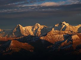
The Jungfrau, at 4,158 meters (13,642 ft) is one of the main summits of the Bernese Alps, located between the northern canton of Bern and the southern canton of Valais, halfway between Interlaken and Fiesch. Together with the Eiger and Mönch, the Jungfrau forms a massive wall of mountains overlooking the Bernese Oberland and the Swiss Plateau, one of the most distinctive sights of the Swiss Alps.

<span class="mw-page-title-main">Aletsch Glacier</span> Largest glacier in the Alps

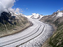
The Aletsch Glacier or Great Aletsch Glacier is the largest glacier in the Alps. It has a length of about 23 km (14 mi) (2014), a volume of 15.4 km3 (3.7 cu mi) (2011), and covers about 81.7 km2 (2011) in the eastern Bernese Alps in the Swiss canton of Valais. The Aletsch Glacier is composed of four smaller glaciers converging at Konkordiaplatz, where its thickness was measured by the ETH to be still near 1 km (3,300 ft). It then continues towards the Rhône valley before giving birth to the Massa. The Aletsch Glacier is – like most glaciers in the world today – a retreating glacier. As of 2016, since 1980 it lost 1.3 kilometres (0.81 mi) of its length, since 1870 3.2 kilometres (2.0 mi), and lost also more than 300 metres (980 ft) of its thickness.

<span class="mw-page-title-main">Eiger</span> Mountain in the Bernese Alps, Switzerland

The Eiger is a 3,967-metre (13,015 ft) mountain of the Bernese Alps, overlooking Grindelwald and Lauterbrunnen in the Bernese Oberland of Switzerland, just north of the main watershed and border with Valais. It is the easternmost peak of a ridge crest that extends across the Mönch to the Jungfrau at 4,158 m (13,642 ft), constituting one of the most emblematic sights of the Swiss Alps. While the northern side of the mountain rises more than 3,000 m (10,000 ft) above the two valleys of Grindelwald and Lauterbrunnen, the southern side faces the large glaciers of the Jungfrau-Aletsch area, the most glaciated region in the Alps. The most notable feature of the Eiger is its nearly 1,800-metre-high (5,900 ft) north face of rock and ice, named Eiger-Nordwand, Eigerwand or just Nordwand, which is the biggest north face in the Alps. This huge face towers over the resort of Kleine Scheidegg at its base, on the eponymous pass connecting the two valleys.

<span class="mw-page-title-main">Finsteraarhorn</span> Mountain in the Bernese Alps

The Finsteraarhorn is a mountain lying on the border between the cantons of Bern and Valais. It is the highest mountain of the Bernese Alps and the most prominent peak of Switzerland. The Finsteraarhorn is the ninth-highest mountain and third-most prominent peak in the Alps. In 2001 the whole massif and surrounding glaciers were designated as part of the Jungfrau-Aletsch World Heritage Site.

<span class="mw-page-title-main">Diablerets</span> Mountain in Switzerland

The Diablerets are a huge ice-covered mountain massif of the Alps, culminating at the Sommet des Diablerets (VS) at 3,216 metres (10,551 ft) above sea level and almost straddling the border between the Swiss cantons of Vaud (VD) and Valais (VS). The northeastern part of the massif stretches also into the canton of Bern (BE).

<span class="mw-page-title-main">Grindelwald</span> Municipality in Canton of Bern, Switzerland

Grindelwald is a village and municipality in the Interlaken-Oberhasli administrative district in the canton of Berne. In addition to the village of Grindelwald, the municipality also includes the settlements of Alpiglen, Burglauenen, Grund, Itramen, Mühlebach, Schwendi, Tschingelberg and Wargistal.

<span class="mw-page-title-main">Jungfraujoch</span> Glacier saddle in the Swiss Alps

The Jungfraujoch is a saddle connecting two major 4000ers of the Bernese Alps: the Jungfrau and the Mönch. It lies at an elevation of 3,463 metres (11,362 ft) above sea level and is directly overlooked by the rocky prominence of the Sphinx. The Jungfraujoch is a glacier saddle, on the upper snows of the Aletsch Glacier, and part of the Jungfrau-Aletsch area, situated on the boundary between the cantons of Bern and Valais, halfway between Interlaken and Fiesch.

<span class="mw-page-title-main">Aletschhorn</span> Mountain in the Bernese Alps

The Aletschhorn is a mountain in the Alps in Switzerland, lying within the Jungfrau-Aletsch region, which has been designated a World Heritage Site by UNESCO. The mountain shares part of its name with the Aletsch Glacier lying at its foot.

<span class="mw-page-title-main">Bernese Oberland</span> Higher part of the canton of Bern, Switzerland

The Bernese Oberland, sometimes also known as the Bernese Highlands, is the highest and southernmost part of the canton of Bern. It is one of the canton's five administrative regions. It constitutes the Alpine region of the canton and the northern side of the Bernese Alps, including many of its highest peaks, among which the Finsteraarhorn, the highest in both range and canton.

<span class="mw-page-title-main">Bietschhorn</span> Mountain in Switzerland

The Bietschhorn is a mountain in canton Wallis to the south of the Bernese Alps in Switzerland. The northeast and southern slopes of the mountain are part of the Jungfrau-Aletsch Protected Area listed as a UNESCO World Heritage Site that also includes the Jungfrau and the Aletsch Glacier. The Bietschhorn is located on the south side of the Lötschental valley and form part of the UNESCO World Heritage Region at the north end of the Bietschtal valley and Baltschiedertal valley. Most climbers approach the mountain from either the Bietschhornhütte or the Baltschiederklause.

<span class="mw-page-title-main">Tourism in Switzerland</span> Overview of tourism in Switzerland

Tourists are drawn to Switzerland's diverse landscape as well as the available activities, which take advantage of the Alpine climate and landscapes, in particular skiing and mountaineering.

<span class="mw-page-title-main">Wildstrubel</span> Massif of the Bernese Alps in Switzerland

The Wildstrubel is a mountain of the Alps, straddling the border between the Swiss cantons of Bern and Valais. It forms a large glaciated massif, about 15 km wide, extending between the Rawil Pass and the Gemmi Pass. Along with the Muverans, the Diablerets and the Wildhorn, the Wildstrubel is one of the four distinct mountain massifs of the Bernese Alps that lie west of the Gemmi Pass. The massif of the Wildstrubel is at the centre between the valleys of Simmental (BE), Engstligental (BE) and the Rhone (VS), the exact location of the tripoint being the summit of the Schneehorn. It comprises several distinct summits, including the Wetzsteinhorn, the Rohrbachstein, the Weisshorn, the Pointe de la Plaine Morte, Mont Bonvin, the Trubelstock and the Schneehorn. The main crest with the almost equally high summits of the Mittelgipfel and the Grossstrubel forms an amphitheatre oriented eastward which ends at the Steghorn and the Daubenhorn. This area encloses the Wildstrubel Glacier. To the southwest, the Wildstrubel overlooks the high plateau of the Plaine Morte Glacier, which also includes an unnamed lake below the Schneehorn.

<span class="mw-page-title-main">Christian Almer</span> 19th-century Swiss mountaineer

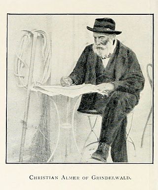
Christian Almer was a Swiss mountain guide and the first ascentionist of many prominent mountains in the western Alps during the golden and silver ages of alpinism. Almer was born and died in Grindelwald, Canton of Bern.

<span class="mw-page-title-main">Wildhorn</span> Mountain in Switzerland

The Wildhorn is a mountain of the Alps, straddling the border between the Swiss cantons of Bern and Valais. At 3,250 metres (10,663 ft) above sea level, it is the highest summit of the Bernese Alps west of the Gemmi Pass. It forms a large glaciated massif, about 10 km wide, extending between the Sanetsch Pass and the Rawil Pass. Along with the Muverans, the Diablerets and the Wildstrubel, the Wildhorn is one of the four distinct mountain massifs of the Bernese Alps that lie west of the Gemmi Pass. The massif of the Wildhorn is at the centre between the valleys of the Saane, Simme and the Rhone (Valais). It comprises several distinct summits, including the Arpelistock, Le Sérac, the Geltenhorn, the Sex Noir, the Sex Rouge, the Schnidehorn and the Six des Eaux Froides. The main crest is between the glaciers named Tungelgletscher and Glacier du Wildhorn. South of the main summit is the almost equally high summit of Mont Pucel. The Wildhorn is surrounded by several large mountain lakes: the Lac de Sénin, the Lauenensee, the Iffigsee, the Lac de Tseuzier and the Lac des Audannes. The Tungelgletscher, on the north-east face, was measured as 1.9 km in length in 1973.

<span class="mw-page-title-main">Eggishorn</span> Mountain in Switzerland

The Eggishorn is a mountain in the southeastern part of the Bernese Alps, located north of Fiesch in the Swiss canton of Valais. A cable car station is located on a secondary summit named Fiescherhorli, 500 metres south of the main peak.

<span class="mw-page-title-main">Jungfraujoch railway station</span>

Jungfraujoch is an underground railway station situated near the Jungfraujoch, in the canton of Valais, a few metres from the border with the canton of Bern. At 3,454 metres (11,332 ft) above sea level, it is the terminus of the Jungfrau Railway and the highest railway station in Switzerland and Europe. The Jungfrau Railway runs from Kleine Scheidegg in the Bernese Oberland, through the Jungfrau Tunnel and crosses the border between the two cantons shortly before the terminus.

<span class="mw-page-title-main">Lötschberg</span>

The Lötschberg is an Alpine mountain massif, usually associated with a major, historically important transit axis of the Alps in Switzerland with, at its core, the Lötschen Pass. The mountain pass, which culminates at nearly 2,700 metres above sea level, are part of the eastern Bernese Alps, whose main crest straddles the border between the cantons of Bern and Valais. The valleys concerned by the Lötschberg are those of the Kander in the Berner Oberland, with Kandersteg at the head of it, and a secluded side-valley of the Upper Valais, the Lötschental, with Ferden at the valley's entrance and at the bottom of the pass.

<span class="mw-page-title-main">Jungfrau-Aletsch protected area</span> Protected area in south-western Switzerland

The Jungfrau-Aletsch protected area is located in south-western Switzerland between the cantons of Bern and Valais. It is a mountainous region in the easternmost side of the Bernese Alps, containing the northern wall of Jungfrau and Eiger, and the largest glaciated area in western Eurasia, comprising the Aletsch Glacier. The Jungfrau-Aletsch protected area is the first World Natural Heritage site in the Alps; it was inscribed in 2001.

References

  1. Natural Wonders of the World. Dorling Kindersley Limited. 2017. p. 138. ISBN   9780241428436. The Alps contain many subranges, some of which are mapped below. The loftiest are the Pennine Alps, which contain 13 of the highest 20 alpine peaks; the Bernese Alps contain four; and the Mont Blanc Massif in the Graian Alps has three.
  2. 1 2 3 4 Ball, John (1866). The Alpine guide, Central Alps. London: Longmans, Green.
  3. "Jungfrau-Aletsch-Bietschhorn World Heritage Site". unesco.org. Archived from the original on 9 November 2011. Retrieved 11 May 2024.