
Cameroon, officially the Republic of Cameroon, is a country in Central Africa. It shares boundaries with Nigeria to the west and north, Chad to the northeast, the Central African Republic to the east, and Equatorial Guinea, Gabon and the Republic of the Congo to the south. Its coastline lies on the Bight of Biafra, part of the Gulf of Guinea and the Atlantic Ocean. Due to its strategic position at the crossroads between West Africa and Central Africa, it has been categorized as being in both camps. Its nearly 27 million people speak 250 native languages and English or French or both.

This article provides a breakdown of the transportation options available in Cameroon. The options available to citizens and tourists include railways, roadways, waterways, pipelines, and airlines. These avenues of transportation are used by citizens for personal transportation, by businesses for transporting goods, and by tourists for both accessing the country and traveling while there.

The East Region occupies the southeastern portion of the Republic of Cameroon. It is bordered to the east by the Central African Republic, to the south by Congo, to the north by the Adamawa Region, and to the west by the Centre and South Regions. With 109,002 km2 of territory, it is the largest region in the nation as well as the most sparsely populated. Historically, the peoples of the East have been settled in Cameroonian territory for longer than any other of the country's many ethnic groups, the first inhabitants being the Baka pygmies.
Articles related to Cameroon include:
Carnot is a city located in the south west of the Central African Republic (CAR), in the prefecture of Mambéré.

Neukamerun was the name of Central African territories ceded by the Third French Republic to the German Empire in 1911. Upon taking office in 1907, Theodor Seitz, governor of Kamerun, advocated the acquisition of territories from the French Congo. Germany's only major river outlet from its Central African possessions was the Congo River, and more territories to the east of Kamerun would allow for better access to that waterway.
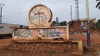
Batouri is a town and commune in the East Province of Cameroon. It is the second largest municipality in the province after the provincial capital Bertoua. It is located on the main road connecting Bertoua to the Central African Republic and to the Cameroonian town of Yokadouma. It had an estimated 33,500 inhabitants as of 2012.

Mayo-Rey is a department of North Province in Cameroon. The department covers an area of 36,529 km2 and as of 2001 had a total population of 242,441 . The capital of the department lies at Tcholliré.

Garoua-Boulaï is a town and commune in Cameroon. The town is on the border with the Central African Republic. Across the border, the nearest CAR settlement accessible by road is Baboua.
Kentzou is a town and commune in Cameroon.

The Kamerun campaign took place in the German colony of Kamerun in the African theatre of the First World War when the British, French and Belgians invaded the German colony from August 1914 to March 1916. Most of the campaign took place in Kamerun but skirmishes also broke out in British Nigeria. By the Spring of 1916, following Allied victories, the majority of German troops and the civil administration fled to the neighbouring neutral colony of Spanish Guinea. The campaign ended in a defeat for Germany and the partition of its former colony between France and Britain.

The African-led International Support Mission to the Central African Republic was an African Union peacekeeping mission to the Central African Republic. It was established on 5 December 2013 by United Nations Security Council resolution 2127 to stabilise the country as a result of the Central African Republic conflict under the Djotodia administration and following the 2013 Central African Republic coup d'état.
Lolo is a village in Kadey Department, East Region, Cameroon, which had a population of about 2,000 in 2013.
As of 31 August 2020, Cameroon hosted a total refugee population of approximately 421,700. Of these, 280,500 were from the Central African Republic, driven by war and insecurity. In the Far North Region, Cameroon hosts 114,300 Nigerian refugees, with the population sharing their already scarce resources with the refugees.
Gbiti is a border town in the East Province in Cameroon.
Mbilé, or Mbilé Refugee Camp, is located near the village of Lolo in Kadey Department, East Region, Cameroon.

The Cameroon–Central African Republic border is 901 km in length and runs from the tripoint with Chad in the north to the tripoint with the Republic of the Congo in the south.

Central African Republic-Germany relations are the bilateral relations between the Central African Republic (CAR) and Germany. The relations between both countries are described by the Federal Foreign Office as "problem-free, but of low intensity". Since the closure of the German Embassy in Bangui, the German Embassy in Cameroon has been responsible for relations with the Central African Republic. The Central African Republic is one of the few countries that does not have its own embassy in Germany. The Central African Embassy in Paris is responsible for relations with Germany.

Cameroon–Germany relations are described as "good" by the German Foreign Office. The two countries share a long common history and Cameroon was a colony of Germany from 1884 to 1918. Also due to German involvement in development cooperation, Germany is "positively perceived" in the country today.


