
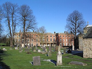
Hucknall, formerly Hucknall Torkard, is a market town in the Ashfield district of Nottinghamshire, England. It lies 7 miles north of Nottingham, 7 miles south-east of Kirkby-in-Ashfield, 9 miles from Mansfield and 10 miles south of Sutton-in-Ashfield. It is the second largest town in the Ashfield district after Sutton-in-Ashfield.

Arnold is a market town and unparished area in the Borough of Gedling in the county of Nottinghamshire in the East Midlands of England. It is situated to the north-east of Nottingham's city boundary. Arnold has the largest town centre in the Borough of Gedling and the most important town centre in the northeastern part of the conurbation of Greater Nottingham. Gedling Borough Council is headquartered in Arnold. Since 1968 Arnold has had a market, and the town used to have numerous factories associated with the hosiery industry. Nottinghamshire Police have been headquartered in Arnold since 1979. At the time of the 2011 United Kingdom census, Arnold had a population of 37,768.

West Bridgford is a town and the administrative centre of the Borough of Rushcliffe in the county of Nottinghamshire, England. It lies immediately south of Nottingham, east of Wilford, north of Ruddington and west of Radcliffe-on-Trent. It is southwest of Colwick and southeast of Beeston which are on the opposite bank of the River Trent. The town is part of the Nottingham Urban Area and had a population of 48,225 in a 2018-estimate.

Radford is an inner-city area of Nottingham, Nottinghamshire, England, located just outside the city centre. The appropriate ward of the City of Nottingham Council is Radford and Park which, in 2011, had a population of 21,414. It is bounded to the south by Lenton and to the east by Nottingham city centre, and comprises around 600 acres (240 ha) of land.
Clifton is a large suburban village and historic manor in the city of Nottingham, England. In 2020 it had an estimated population of 22,749.

Wollaton is a suburb and former parish in the western part of Nottingham, England. Wollaton has two wards in the City of Nottingham, with a total population of 24,693 at the 2011 census. It is home to Wollaton Hall, with its museum, deer park, lake, walks and golf course.
Sherwood is a large district and ward of the city of Nottingham, England, 1.5 miles (2.4 km) north of the city centre. The population at the 2011 census was 15,414. It is bordered by Woodthorpe to the northeast, Mapperley to the east, Carrington to the south, New Basford and Basford to the west, and Daybrook and Bestwood to the north.
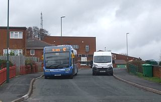
St Ann's is a large district of the city of Nottingham, in the English ceremonial county of Nottinghamshire. The population of the district at the time of the United Kingdom census, 2011 was 19,316.

Bulwell is a market town in the City of Nottingham, in Nottinghamshire, England. It is 3 miles (5 km) south-west of Hucknall and 4.5 miles (7 km) to the north-west of Nottingham. The United Kingdom Census 2011 recorded the population of Bulwell at 29,771 which amounted to over 10 per cent of Nottingham city's population. The 2011 census gave a population of 16,157 for the Bulwell ward of Nottingham City Council. There is an adjacent ward, Bulwell Forest, which includes Highbury Vale, Rise Park and the west of Top Valley), its population at the same census being 13,614.
Bestwood Village is an area and civil parish in the Gedling district of Nottinghamshire. Until 1 April 2018 it was part of the civil parish of Bestwood St. Albans. A small part of the village falls within the Ashfield district council area. There have been several new housing estates built recently including the redevelopment of the former Bayles and Whylie factory site which was a former glue mill. It is to the east of Hucknall and north of Bulwell. It is neighboured to the north by the village of Papplewick. It is also close to the Bestwood Park Estate which is in the City of Nottingham.
Nuthall is a village and civil parish located in Nottinghamshire, England, neighbouring Kimberley, Watnall, Cinderhill and Basford. The population of the civil parish at the 2011 census was 6,311. It is part of the borough of Broxtowe.

Lenton Abbey is a large housing estate, forming a neighbourhood in Nottingham, close to Wollaton, Beeston and the University of Nottingham.

Bilborough is a suburb of the city of Nottingham, in the Nottingham district, in the ceremonial county of Nottinghamshire, England. The population of the City of Nottingham ward at the 2011 census was 16,792.

Bestwood Park is a large post-war council estate located to the north of the city of Nottingham, England, and roughly bounded by Beckhampton Road, Oxclose Lane and Queens Bower Road.

Broxtowe is a council estate in the City of Nottingham which is part of the Aspley ward. The estate is located 3 miles (5 km) from the City Centre and lies west of Aspley and Cinderhill, south of Bulwell, east of Strelley and north of Bilborough. At the 2001 census, the estate had a population of 4,847.

Warren Hill is an area within the market town of Arnold in the English ceremonial county of Nottinghamshire. Located in the civil parish of St. Albans, it is in the local government district of Gedling. The area is roughly 1.5 miles (2.4 km) from Arnold town centre and about 4 miles (6 km) from Nottingham. The surrounding areas include Top Valley to the south, Rise Park to the west, Arnold and the suburb of Redhill to the east and Bestwood Country Park and Bestwood Village to the north. Most of the area consists of newly built housing estates with mainly 3-4 bedroom semi-detached houses as well as some newly built terraced housing and bungalows.

Highbury Vale is an area located in the city of Nottingham, and is located in the Bulwell Forest ward. The area is located roughly 5.4 miles (8.7 km) from the City Centre, and about 1 mile (2 km) from Bulwell. Surrounding areas include Bulwell towards the North, Bestwood to the east, Hempshill Vale to the west and Cinderhill and Basford towards the south. Highbury Vale and Hempshill Vale are classed as a part of Bulwell. At the 2001 census, the area had a population of 4,530.

Beechdale is suburban area in the City of Nottingham. The area is located roughly 2.2 miles (3.5 km) from the City Centre and surrounding areas include Bilborough to the west, Aspley to the north, Radford to the east and Wollaton to the south. At the 2001 Census, the area had a population of 5,537.

Cinderhill is an area in the City of Nottingham. It is located roughly 3.1 miles (5.0 km) from the City Centre, and surrounding areas include Bulwell to the north, Aspley and Broxtowe to the south, Basford to the east and Nuthall to the west.

Bulwell Hall Estate is a council estate in the City of Nottingham, and is located in the Bulwell ward. The estate is located roughly 0.9 miles (1.4 km) from Bulwell and about 5 miles (8 km) from the city centre. Surrounding areas include Hucknall and Bestwood Village towards the north, Rise Park to the east and Bulwell to the south. At the 2001 Census, the estate had a population of 2,181.

