Bicske District

Last updated
Bicske District
Bicskei járás
Districts of Hungary
HUN Bicske Cimer.svg
Coat of arms
Bicskei jaras.png
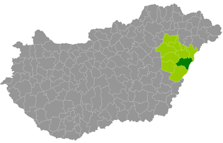
Bicske District within Hungary and Fejér County.
Country Flag of Hungary.svg  Hungary
County Fejér
District seat Bicske
Area
  Total 578.25 km2 (223.26 sq mi)
Area rank 4th in Fejér
Population (2011 census)
  Total 34,370
  Rank 3rd in Fejér
  Density 66/km2 (170/sq mi)

Bicske (Hungarian : Bicskei járás) is a district in north-eastern part of Fejér County. Bicske is also the name of the town where the district seat is found. The district is located in the Central Transdanubia Statistical Region.

Hungarian language language spoken in and around Hungary

Hungarian is a Finno-Ugric language spoken in Hungary and several neighbouring countries. It is the official language of Hungary and one of the 24 official languages of the European Union. Outside Hungary it is also spoken by communities of Hungarians in the countries that today make up Slovakia, western Ukraine (Subcarpathia), central and western Romania (Transylvania), northern Serbia (Vojvodina), northern Croatia, and northern Slovenia. It is also spoken by Hungarian diaspora communities worldwide, especially in North America and in Israel. Like Finnish and Estonian, Hungarian belongs to the Uralic language family. With 13 million speakers, it is its largest member in terms of speakers.

Fejér County Counties of Hungary in Central Transdanubia

Fejér is an administrative county in Central Hungary. It lies on the west bank of the river Danube and nearly touches the eastern shore of Lake Balaton. It shares borders with the Hungarian counties Veszprém, Komárom-Esztergom, Pest, Bács-Kiskun, Tolna and Somogy. The capital of Fejér county is Székesfehérvár.

Bicske Town in Fejér, Hungary

Bicske [] is a town in Fejér county, Hungary. Its name is also spelled Bykche, Biccke, Bykcze, Biczke, and Bitske. It is around 35 km (22 mi) west of Budapest. Its administration has undergone many changes; it has been a settlement, a village, a market town, and a village constituting an administrative division.

Contents

Geography

Bicske District borders with Oroszlány District and Tatabánya District (Komárom-Esztergom County) to the north, Budakeszi District (Pest County) to the east, Martonvásár District, Gárdony District and Székesfehérvár District to the south, Mór District to the west. The number of the inhabited places in Bicske District is 15.

Oroszlány District Districts of Hungary in Komárom-Esztergom

Oroszlány is a district in southern part of Komárom-Esztergom County. Oroszlány is also the name of the town where the district seat is found. The district is located in the Central Transdanubia Statistical Region.

Tatabánya District Districts of Hungary in Komárom-Esztergom

Tatabánya is a district in south-eastern part of Komárom-Esztergom County. Tatabánya is also the name of the town where the district seat is found. The district is located in the Central Transdanubia Statistical Region.

Komárom-Esztergom County Counties of Hungary in Central Transdanubia

Komárom-Esztergom is an administrative Hungarian county in Central Transdanubia Region; its shares its northern border the Danube with Slovakia. It shares borders with the Hungarian counties of Győr-Moson-Sopron, Veszprém, Fejér and Pest and the Slovakian Nitra Region. Its county seat is Tatabánya.

Municipalities

The district has 2 towns, 1 large village and 12 villages. (ordered by population, as of 1 January 2012) [1]

Alcsútdoboz Place in Central Transdanubia, Hungary

Alcsútdoboz is a village in Fejér county, Hungary.

Bodmér Place in Central Transdanubia, Hungary

Bodmér is a village in Fejér county, Hungary.

Csabdi Place in Fejér, Hungary

Csabdi is a village in Fejér county, Hungary.

The bolded municipalities are cities, italics municipality is large village.

See also

Related Research Articles

Cristian, Brașov Commune in Brașov County, Romania

Cristian is a commune in Brașov County, Romania. It is composed of a single village, Cristian.

Karniszewo Village in Greater Poland, Poland

Karniszewo is a village in the administrative district of Gmina Mieleszyn, within Gniezno County, Greater Poland Voivodeship, in west-central Poland. It lies approximately 5 kilometres (3 mi) south of Mieleszyn, 14 km (9 mi) north-west of Gniezno, and 47 km (29 mi) north-east of the regional capital Poznań.

Karcag District Districts of Hungary in Jász-Nagykun-Szolnok

Karcag is a district in eastern part of Jász-Nagykun-Szolnok County, Hungary. Karcag is also the name of the town where the district seat is found. The district is located in the Northern Great Plain Statistical Region. This district is a part of Nagykunság historical and geographical region.

Tiszafüred District Districts of Hungary in Jász-Nagykun-Szolnok

Tiszafüred is a district in north-eastern part of Jász-Nagykun-Szolnok County. Tiszafüred is also the name of the town where the district seat is found. The district is located in the Northern Great Plain Statistical Region.

Derecske District Districts of Hungary in Hajdú-Bihar

Derecske is a district in central-eastern part of Hajdú-Bihar County. Derecske is also the name of the town where the district seat is found. The district is located in the Northern Great Plain Statistical Region.

Kiskunmajsa District Districts of Hungary in Bács-Kiskun

Kiskunmajsa is a district in eastern part of Bács-Kiskun County. Kiskunmajsa is also the name of the town where the district seat is found. The district is located in the Southern Great Plain Statistical Region.

Békéscsaba District Districts of Hungary in Békés

Békéscsaba is a district in central-southern part of Békés County. Békéscsaba is also the name of the town where the district seat is found. The district is located in the Southern Great Plain Statistical Region.

Cigánd District Districts of Hungary in Borsod-Abaúj-Zemplén

Cigánd is a district in north-eastern part of Borsod-Abaúj-Zemplén County. The district seat is in a town that is called Cigánd as well. The district is located in the Northern Hungary Statistical Region.

Aszód District Districts of Hungary in Pest

Aszód is a district in north-eastern part of Pest County. Aszód is also the name of the town where the district seat is found. The district is located in the Central Hungary Statistical Region.

Budakeszi District Districts of Hungary in Pest

Budakeszi is a district in western part of Pest County. Budakeszi is also the name of the town where the district seat is found. The district is located in the Central Hungary Statistical Region.

Dunakeszi District Districts of Hungary in Pest

Dunakeszi is a district in central-northern part of Pest County. Dunakeszi is also the name of the town where the district seat is found. The district is located in the Central Hungary Statistical Region.

Esztergom District Districts of Hungary in Komárom-Esztergom

Esztergom is a district in north-eastern part of Komárom-Esztergom County. Esztergom is also the name of the town where the district seat is found. The district is located in the Central Transdanubia Statistical Region.

Komárom District Districts of Hungary in Komárom-Esztergom

Komárom is a district in north-western part of Komárom-Esztergom County. Komárom is also the name of the town where the district seat is found. The district is located in the Central Transdanubia Statistical Region.

Gárdony District Districts of Hungary in Fejér

Gárdony is a district in central-eastern part of Fejér County. Gárdony is also the name of the town where the district seat is found. The district is located in the Central Transdanubia Statistical Region.

Enying District Districts of Hungary in Fejér

Enying is a district in south-western part of Fejér County. Enying is also the name of the town where the district seat is found. The district is located in the Central Transdanubia Statistical Region.

Székesfehérvár District Districts of Hungary in Fejér

Székesfehérvár is a district in central-western part of Fejér County. Székesfehérvár is also the name of the town where the district seat is found. The district is located in the Central Transdanubia Statistical Region.

Mór District Districts of Hungary in Fejér

Mór is a district in north-western part of Fejér County. Sárbogárd is also the name of the town where the district seat is found. The district is located in the Central Transdanubia Statistical Region.

References

Coordinates: 47°29′00″N18°38′00″E / 47.4833°N 18.6333°E / 47.4833; 18.6333

Geographic coordinate system Coordinate system

A geographic coordinate system is a coordinate system that enables every location on Earth to be specified by a set of numbers, letters or symbols. The coordinates are often chosen such that one of the numbers represents a vertical position and two or three of the numbers represent a horizontal position; alternatively, a geographic position may be expressed in a combined three-dimensional Cartesian vector. A common choice of coordinates is latitude, longitude and elevation. To specify a location on a plane requires a map projection.